
Recommended
More Related Content
What's hot
What's hot (20)
Similar to India size&location part 2
Similar to India size&location part 2 (20)
Recently uploaded
Recently uploaded (20)
India size&location part 2
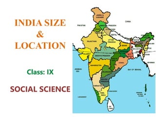
- 1. INDIA SIZE & LOCATION Class: IX SOCIAL SCIENCE
- 2. CHAPTER -1 INDIA: SIZE AND LOCATION CONTENT • INTRODUCTION • LOCATION • LATITUDE • LONGITUDE • SIZE OF INDIA • EXTENT • FOLD MOUNTAINS • STANDARD MERIDIAN OF INDIA • INDIAN OCEAN NAMED AFTER INDIA • INDIA AND THE WORLD • INDIA CONTACT WITH THE WORLD • INDIA’S NEIGHBOUR
- 3. INTRODUCTION • India is one of the oldest civilizations and has a remarkable history. After Independence from British rule, it achieved multi faceted socio economic progress. India also made a remarkable progress in the field of agriculture, industry, technology and overall economic development.
- 4. LOCATION India is lying entirely in the Northern hemisphere as shown in the figure below. The land extends between latitudes 8°4’N and 37°6’N and longitudes 68°7’E and 97°25’E. The Tropic of Cancer (23° 30’N) divides India into almost two equal parts. It passes through the States of Gujarat, Rajasthan, Madhya Pradesh, Chattisgarh, Jharkhand, West Bengal, Tripura and Mizoram. Andaman and Nicobar islands situated in South-East of mainland in Bay of Bengal. Lakshadweep islands situated South-West of mainland in Arabian Sea.
- 5. LATITUDE Latitude is a geographic coordinate that specifies the north–south position of a point on the Earth's surface. Latitude is an angle (defined below) which ranges from 0° at the Equator to 90° (North or South) at the poles LONGITUDE Longitude, is a geographic coordinate that specifies the east–west position of a point on the Earth's surface, or the surface of a celestial body.
- 6. LONGITUDINAL The latitudinal and longitudinal extent of India is about 300. The North-South extent is 3214 km and East-West extent is 2933 km. The distance between any two lines of longitude is maximum at the equator and goes on decreasing as one goes from the equator to the poles
- 7. SIZE Area • India’s total area accounts for about 2.4% of the total geographical area of the world. Thus, it is the 7th largest country in the world, by its size. • India has a land boundary of about 15,200 km. Length • The total length of the coastline of the mainland is 7,516.6 km including Andaman and Nicobar and Lakshadweep. • India is bounded by the mountains in the northwest, north and northeast. South of about 22° north latitude, it begins to taper and extends towards the Indian Ocean, dividing it into two seas, the Arabian Sea on the west and the Bay of Bengal on its east. Meridian of India • Time along the Standard Meridian of India (82°30’E) passing through Mirzapur (in Uttar Pradesh) is taken as the standard time for India. SIZE OF INDIA
- 8. EXTENT India is bounded by young fold mountains in the North-West, North and North- East. India’s land mass begins to form cone shape in South of 220 North Latitude The East West extent appears smaller than the North- South extent
- 9. FOLD MOUNTAINS Mountains which develop when two tectonic plates come together causing compression, result in bulking and folding of rocks.
- 10. 82°30’E HAS BEEN SELECTED AS THE STANDARD MERIDIAN OF INDIA • From Gujarat to Arunachal Pradesh there is a time lag (period of time) of about two hours, Hence, time along the Standard Meridian of India (82°30’E) passing through Mirzapur, Uttar Pradesh is taken as the Standard time for the whole country. Otherwise different regions of India would have different times, which would create problems, so to have one common standard time for the whole country.
- 11. INDIAN OCEAN NAMED AFTER OUR COUNTRY • India has the longest coastline on the Indian Ocean. India holds a central location which is at the head of the Indian Ocean. India in ancient times was an important location in the Indian Ocean which connected Europe with countries of Southeast Asia.
- 12. INDIA AND THE WORLD The Indian landmass has a central location between the East and West Asia. India is a southward extension of the Asian continent. The trans-Indian Ocean routes connect the countries of Europe in the West and the countries of East Asia. India has a longest coastline as compared to the other countries. India’s contacts with the World have continued through the ages. This eminent position is the reason which justifies the naming of the Indian Ocean after the name of the country. The spices, muslin and other merchandise were taken from India to different countries. On the other hand, the influence of Greek sculpture, and the architectural styles of domes and minarets from West Asia can be seen in different parts of India.
- 13. INDIA CONTACTS WITH THE WORLD Land Routes • The land routes of India are much older than sea route. Various passes across mountains in the north have provided passages to the ancient travelers as ocean limited such interaction for a long time. Merchandise • The Indian numerals and the decimal system as well as given spices, muslin and other merchandise to different countries. Architectural Styles • Also, the influence of Greek sculpture, and the architectural styles of dome and minarets from West Asia can be seen in different parts of India.
- 14. INDIA AND IT’S NEIGHBOURS Pakistan and Afghanistan in the northwest The southern neighbours across the sea consist of the two island countries, Sri Lanka and Maldives. India has had strong geographical and historical links with her neighbours. Myanmar and Bangladesh in the east China (Tibet), Nepal and Bhutan in the north