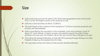
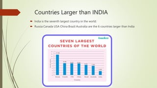
Geography Chapter 1 India -
Size
Class Notes By Jishnu
Size
 India’s total area accounts for about 2.4% of the total geographical area of the world.
Thus, it is the 7th largest country in the world by its size.
 India has a land boundary of about 15,200 km.
 The total length of the coastline of the mainland is 7,516.6 km including Andaman and
Nicobar and Lakshadweep.
 India is bounded by the mountains in the northwest, north and northeast. South of
about 22° north latitude, it begins to taper and extends towards the Indian Ocean,
dividing it into two seas, the Arabian Sea on the west and the Bay of Bengal on its east.
 Time along the Standard Meridian of India (82°30’E) passing through Mirzapur (in Uttar
Pradesh) is taken as the standard time for India.
 The map below shows the Extent of India and the Standard Meridian.
India And The World
 The spices, muslin and other merchandise were taken from India to different
countries.
 The influence of Greek sculpture and the architectural styles of domes and minarets
from West Asia can be seen in different parts of India.
 The Indian landmass has a central location between the East and West Asia. India is
a southward extension of the Asian continent.
 The trans-Indian Ocean routes connect the countries of Europe in the West and the
countries of East Asia.
 No other country has as long a coastline on the Indian Ocean as India has.
 India’s contacts with the World have continued through the ages.
Countries Larger than INDIA
 India is the seventh largest country in the world.
 Russia Canada USA China Brazil Australia are the 6 countries larger than India
Union Territories of India - Complete List
 Ladakh.
 Jammu & Kashmir.
 Puducherry.
 Lakshadweep.
 Delhi.
 Chandigarh.
 Dadra and Nagar Haveli and Daman & Diu.
 Andaman and Nicobar Islands.
Summary
Size
India And The World
Countries Larger than INDIA
Union Territories of India -
Complete List

Geography Chapter 1 India -Size.pptx

  • 1.
    Geography Chapter 1India - Size Class Notes By Jishnu
  • 2.
    Size  India’s totalarea accounts for about 2.4% of the total geographical area of the world. Thus, it is the 7th largest country in the world by its size.  India has a land boundary of about 15,200 km.  The total length of the coastline of the mainland is 7,516.6 km including Andaman and Nicobar and Lakshadweep.  India is bounded by the mountains in the northwest, north and northeast. South of about 22° north latitude, it begins to taper and extends towards the Indian Ocean, dividing it into two seas, the Arabian Sea on the west and the Bay of Bengal on its east.  Time along the Standard Meridian of India (82°30’E) passing through Mirzapur (in Uttar Pradesh) is taken as the standard time for India.  The map below shows the Extent of India and the Standard Meridian.
  • 3.
    India And TheWorld  The spices, muslin and other merchandise were taken from India to different countries.  The influence of Greek sculpture and the architectural styles of domes and minarets from West Asia can be seen in different parts of India.  The Indian landmass has a central location between the East and West Asia. India is a southward extension of the Asian continent.  The trans-Indian Ocean routes connect the countries of Europe in the West and the countries of East Asia.  No other country has as long a coastline on the Indian Ocean as India has.  India’s contacts with the World have continued through the ages.
  • 4.
    Countries Larger thanINDIA  India is the seventh largest country in the world.  Russia Canada USA China Brazil Australia are the 6 countries larger than India
  • 5.
    Union Territories ofIndia - Complete List  Ladakh.  Jammu & Kashmir.  Puducherry.  Lakshadweep.  Delhi.  Chandigarh.  Dadra and Nagar Haveli and Daman & Diu.  Andaman and Nicobar Islands.
  • 6.
    Summary Size India And TheWorld Countries Larger than INDIA Union Territories of India - Complete List