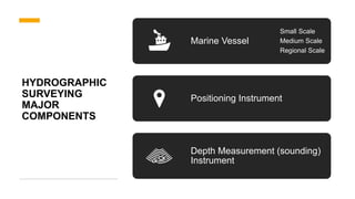
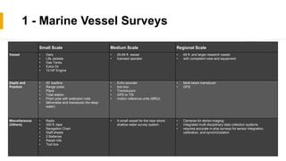
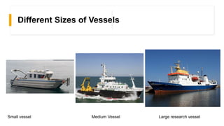
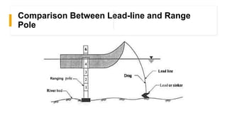
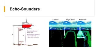
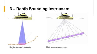
HYDROGRAPHIC
SURVEYING
LECTURE 2:
BASIC MEASUREMENTS AND EQUIPMENTS
BY: AHMED YASSER AHMED MOHAMED NASSAR
SECTION: 1 ID:20
HYDROGRAPHIC
SURVEYING
MAJOR
COMPONENTS
Marine Vessel
Small Scale
Medium Scale
Regional Scale
Positioning Instrument
Depth Measurement (sounding)
Instrument
1 - Marine Vessel Surveys
Small Scale Medium Scale Regional Scale
Vessel • Oars
• Life Jackets
• Gas Tanks
• Extra Oil
• 10 HP Engine
• 25-65 ft. vessel
• licensed operator
• 65 ft. and larger research vessel
• with competent crew and equipment
Depth and
Position
• 50’ leadline
• Range poles
• Plans
• Total station
• Prism pole with extension rods
• fathometer and transducer (for deep
water)
• Echo sounder
• tool box
• Transducers
• GPS or TSI
• motion reference units (MRU).
• Multi-beam transducer
• GPS
Miscellaneous
(Others)
• Radio
• 300 ft. tape
• Navigation Chart
• Staff sheets
• 2 Batteries
• Repair kits
• Tool box
• A small vessel for the near-shore
shallow water survey system
• Cameras for stereo imaging
• Integrated multi-disciplinary data collection systems
• requires accurate in-ship surveys for sensor integration,
calibration, and synchronization.
Different Sizes of Vessels
Small vessel Medium Vessel Large research vessel
Comparison Between Lead-line and Range
Pole
Ranging
Echo-Sounders
2 – Positioning Instrument
• Modern methods
• Land-based electronic ranging
• Space-based positioning
Basic positioning method is Resection.
Positioning method is changing with the
change in project specifications and site
conditions
Preferred method for positioning offshore
surveys is GPS
• Traditional instruments
• Sextant
• Transit
• Stadia
• EDM
GPS
POSITIONING
3 – Depth Sounding Instrument
1. Transducer send a sonic pulse to sea floor.
2. Sonic pulse (sound wave) propagates, hits the
sea floor and starts to reflect.
3. Receiver detect the returned pulses (waves)
Note that the pulse take the distance forth-and-
back, so with known the time of the pulse and the
sound speed we can calculate the Depth by the
relation:
2 ∗ 𝐷𝑒𝑝𝑡ℎ = 𝑡𝑖𝑚𝑒 ∗ 𝑠𝑝𝑒𝑒𝑑
3 – Depth Sounding Instrument
Single beam echo-sounder Multi beam echo-sounder
THANKS

Hydrographic Surveying - Basic Measurements And Equipments

  • 1.
    HYDROGRAPHIC SURVEYING LECTURE 2: BASIC MEASUREMENTSAND EQUIPMENTS BY: AHMED YASSER AHMED MOHAMED NASSAR SECTION: 1 ID:20
  • 2.
    HYDROGRAPHIC SURVEYING MAJOR COMPONENTS Marine Vessel Small Scale MediumScale Regional Scale Positioning Instrument Depth Measurement (sounding) Instrument
  • 3.
    1 - MarineVessel Surveys Small Scale Medium Scale Regional Scale Vessel • Oars • Life Jackets • Gas Tanks • Extra Oil • 10 HP Engine • 25-65 ft. vessel • licensed operator • 65 ft. and larger research vessel • with competent crew and equipment Depth and Position • 50’ leadline • Range poles • Plans • Total station • Prism pole with extension rods • fathometer and transducer (for deep water) • Echo sounder • tool box • Transducers • GPS or TSI • motion reference units (MRU). • Multi-beam transducer • GPS Miscellaneous (Others) • Radio • 300 ft. tape • Navigation Chart • Staff sheets • 2 Batteries • Repair kits • Tool box • A small vessel for the near-shore shallow water survey system • Cameras for stereo imaging • Integrated multi-disciplinary data collection systems • requires accurate in-ship surveys for sensor integration, calibration, and synchronization.
  • 4.
    Different Sizes ofVessels Small vessel Medium Vessel Large research vessel
  • 5.
    Comparison Between Lead-lineand Range Pole Ranging
  • 6.
  • 7.
    2 – PositioningInstrument • Modern methods • Land-based electronic ranging • Space-based positioning Basic positioning method is Resection. Positioning method is changing with the change in project specifications and site conditions Preferred method for positioning offshore surveys is GPS • Traditional instruments • Sextant • Transit • Stadia • EDM
  • 8.
  • 9.
    3 – DepthSounding Instrument 1. Transducer send a sonic pulse to sea floor. 2. Sonic pulse (sound wave) propagates, hits the sea floor and starts to reflect. 3. Receiver detect the returned pulses (waves) Note that the pulse take the distance forth-and- back, so with known the time of the pulse and the sound speed we can calculate the Depth by the relation: 2 ∗ 𝐷𝑒𝑝𝑡ℎ = 𝑡𝑖𝑚𝑒 ∗ 𝑠𝑝𝑒𝑒𝑑
  • 10.
    3 – DepthSounding Instrument Single beam echo-sounder Multi beam echo-sounder
  • 11.