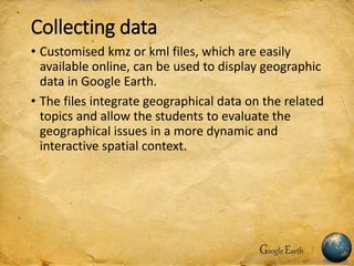
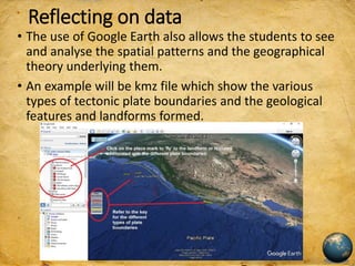
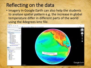
SlideShare a Scribd company logo
1 of 14
Google Earth in Inquiry-based Learning
Presented to you by
Mrs Lily Lee
Ms June Cheong
Ms Kelly Tan
Google Earth in inquiry-based learning
Integrating the use of Google Earth in
inquiry-based learning helps the students
to better understand geographical issues
in a more dynamic and interactive spatial
context.
Google Earth
Sparkling curiosity
• The use of Google Earth helps to sparkle the
curiosity in the students to raise questions on
authentic geographical issues.
• Navigating Google Earth using street views, the
students can better compare the features of places
supporting authentic learning with the virtual
fieldtrips.
Google Earth
Collecting data
• Customised kmz or kml files, which are easily
available online, can be used to display geographic
data in Google Earth.
• The files integrate geographical data on the related
topics and allow the students to evaluate the
geographical issues in a more dynamic and
interactive spatial context.
Google Earth
Reflecting on data
• The use of Google Earth also allows the students to see
and analyse the spatial patterns and the geographical
theory underlying them.
• An example will be kmz file which show the various
types of tectonic plate boundaries and the geological
features and landforms formed.
Reflecting on the data
• Imagery in Google Earth can also help the students
to analyse spatial pattern e.g. the increase in global
temperature differ in different parts of the world
using the 4degrees kmz file.
Reflecting on the data
• Imagery in Google Earth can also help the students
to see the changes over time. An example will the
kmz file on the Hurricane Katrina over New
Orleans.
Map reading and Google Earth
• Google Earth allows the students to see the
authenticity of the data from topographical maps
and better interpret them. I have created a kmz file
which I have place marked and added information
from the topographical map.
Google Earth in Geographical Investigation
• A virtual trip/recee can be done before the actual
fieldwork.
Using Google Earth to investigate rate of
deforestation in different countries.
Google Earth for Lower Secondary (Sec 1)
Google Earth for Lower Secondary (Sec 2)
• Using Google Earth for case study. The Favela kmz
file define the boundary of the slum area in Brazil.
• Taking a virtual trip to the favela using street view.
Observe the living conditions of the people.
Google Earth for Lower Secondary
Use of Google Earth
• You can download Google Earth free
@ http://www.google.com/earth/download/ge/agr
ee.html
• Use of Google Earth for Physical Geography
https://sites.google.com/a/moe.edu.sg/sec3geog/google-earth
• Use of Google Earth for Sec 1 Geography -
deforestation
https://sites.google.com/a/moe.edu.sg/sec-1-geog/google-earth
• Use of Google Earth for Sec 2 Geography
https://sites.google.com/a/moe.edu.sg/sec-2-geog/using-google-earth
Google Earth
More of Mrs Lily Lee’s sharing on http://geogshare.blogspot.com

More Related Content

What's hot

Miami Valley Land Development Suitability Assessmentboard010809 1232553085175...
Miami Valley Land Development Suitability Assessmentboard010809 1232553085175...Miami Valley Land Development Suitability Assessmentboard010809 1232553085175...
Miami Valley Land Development Suitability Assessmentboard010809 1232553085175...Vermilli
 
World studies geog term sheet
World studies geog term sheetWorld studies geog term sheet
World studies geog term sheetJoe McClung
 
Why spatially determining of SDGs matters for landscapes in the German Lusati...
Why spatially determining of SDGs matters for landscapes in the German Lusati...Why spatially determining of SDGs matters for landscapes in the German Lusati...
Why spatially determining of SDGs matters for landscapes in the German Lusati...Global Landscapes Forum (GLF)
 
David McCann-DSDP Leg 41
David McCann-DSDP Leg 41David McCann-DSDP Leg 41
David McCann-DSDP Leg 41David McCann
 
Using Google Earth in the K-12 Classroom
Using Google Earth in the K-12 ClassroomUsing Google Earth in the K-12 Classroom
Using Google Earth in the K-12 ClassroomCourtney F
 
Commercializing Space: From the Moon to Mars
Commercializing Space: From the Moon to MarsCommercializing Space: From the Moon to Mars
Commercializing Space: From the Moon to MarsLarry Smarr
 
Digital Soil Mapping Tools and Methods 1
Digital Soil Mapping Tools and Methods 1Digital Soil Mapping Tools and Methods 1
Digital Soil Mapping Tools and Methods 1FAO
 
Role of geo-informatics in land use/land cover
Role of geo-informatics in land use/land coverRole of geo-informatics in land use/land cover
Role of geo-informatics in land use/land coverRohit Kumar
 
Google Apps for Educators
Google Apps for EducatorsGoogle Apps for Educators
Google Apps for EducatorsSpiro Bolos
 
use of gis and remote sensing in wildlife and forestry
use of gis and remote sensing in wildlife and forestryuse of gis and remote sensing in wildlife and forestry
use of gis and remote sensing in wildlife and forestrywaiton sherekete
 
2013-06-09 State of the Map US: Public Lab + OpenStreetMap
2013-06-09 State of the Map US: Public Lab + OpenStreetMap2013-06-09 State of the Map US: Public Lab + OpenStreetMap
2013-06-09 State of the Map US: Public Lab + OpenStreetMapLizBarry
 
Esri and the Scientific Community
Esri and the Scientific CommunityEsri and the Scientific Community
Esri and the Scientific CommunityDawn Wright
 
Remote Sensing and GIS in Land Use / Land Cover Mapping
Remote Sensing and GIS in Land Use / Land Cover MappingRemote Sensing and GIS in Land Use / Land Cover Mapping
Remote Sensing and GIS in Land Use / Land Cover MappingVenkatKamal1
 
land suitability under R.S and G.I.S
land suitability under R.S and G.I.Sland suitability under R.S and G.I.S
land suitability under R.S and G.I.Shena parveen
 
CouchDB Day NYC 2017: Using Geospatial Data in Cloudant & CouchDB
CouchDB Day NYC 2017: Using Geospatial Data in Cloudant & CouchDBCouchDB Day NYC 2017: Using Geospatial Data in Cloudant & CouchDB
CouchDB Day NYC 2017: Using Geospatial Data in Cloudant & CouchDBIBM Cloud Data Services
 
CBS için Veri İndirilebilecek Siteler
CBS için Veri İndirilebilecek SitelerCBS için Veri İndirilebilecek Siteler
CBS için Veri İndirilebilecek SitelerAlı ılhan
 

What's hot (19)

Miami Valley Land Development Suitability Assessmentboard010809 1232553085175...
Miami Valley Land Development Suitability Assessmentboard010809 1232553085175...Miami Valley Land Development Suitability Assessmentboard010809 1232553085175...
Miami Valley Land Development Suitability Assessmentboard010809 1232553085175...
 
World studies geog term sheet
World studies geog term sheetWorld studies geog term sheet
World studies geog term sheet
 
Why spatially determining of SDGs matters for landscapes in the German Lusati...
Why spatially determining of SDGs matters for landscapes in the German Lusati...Why spatially determining of SDGs matters for landscapes in the German Lusati...
Why spatially determining of SDGs matters for landscapes in the German Lusati...
 
David McCann-DSDP Leg 41
David McCann-DSDP Leg 41David McCann-DSDP Leg 41
David McCann-DSDP Leg 41
 
Using Google Earth in the K-12 Classroom
Using Google Earth in the K-12 ClassroomUsing Google Earth in the K-12 Classroom
Using Google Earth in the K-12 Classroom
 
Commercializing Space: From the Moon to Mars
Commercializing Space: From the Moon to MarsCommercializing Space: From the Moon to Mars
Commercializing Space: From the Moon to Mars
 
Digital Soil Mapping Tools and Methods 1
Digital Soil Mapping Tools and Methods 1Digital Soil Mapping Tools and Methods 1
Digital Soil Mapping Tools and Methods 1
 
Role of geo-informatics in land use/land cover
Role of geo-informatics in land use/land coverRole of geo-informatics in land use/land cover
Role of geo-informatics in land use/land cover
 
Google Apps for Educators
Google Apps for EducatorsGoogle Apps for Educators
Google Apps for Educators
 
use of gis and remote sensing in wildlife and forestry
use of gis and remote sensing in wildlife and forestryuse of gis and remote sensing in wildlife and forestry
use of gis and remote sensing in wildlife and forestry
 
2013-06-09 State of the Map US: Public Lab + OpenStreetMap
2013-06-09 State of the Map US: Public Lab + OpenStreetMap2013-06-09 State of the Map US: Public Lab + OpenStreetMap
2013-06-09 State of the Map US: Public Lab + OpenStreetMap
 
GPS Connections
GPS ConnectionsGPS Connections
GPS Connections
 
Esri and the Scientific Community
Esri and the Scientific CommunityEsri and the Scientific Community
Esri and the Scientific Community
 
Remote Sensing and GIS in Land Use / Land Cover Mapping
Remote Sensing and GIS in Land Use / Land Cover MappingRemote Sensing and GIS in Land Use / Land Cover Mapping
Remote Sensing and GIS in Land Use / Land Cover Mapping
 
land suitability under R.S and G.I.S
land suitability under R.S and G.I.Sland suitability under R.S and G.I.S
land suitability under R.S and G.I.S
 
CouchDB Day NYC 2017: Using Geospatial Data in Cloudant & CouchDB
CouchDB Day NYC 2017: Using Geospatial Data in Cloudant & CouchDBCouchDB Day NYC 2017: Using Geospatial Data in Cloudant & CouchDB
CouchDB Day NYC 2017: Using Geospatial Data in Cloudant & CouchDB
 
CBS için Veri İndirilebilecek Siteler
CBS için Veri İndirilebilecek SitelerCBS için Veri İndirilebilecek Siteler
CBS için Veri İndirilebilecek Siteler
 
Geospatial Analysis and Open Data - Forest and Climate
Geospatial Analysis and Open Data - Forest and ClimateGeospatial Analysis and Open Data - Forest and Climate
Geospatial Analysis and Open Data - Forest and Climate
 
Hawaii november conference outline
Hawaii november conference outlineHawaii november conference outline
Hawaii november conference outline
 

Similar to Humanities google earth

Deeper understanding through Google Earth
Deeper understanding through Google EarthDeeper understanding through Google Earth
Deeper understanding through Google EarthKevin Amboe
 
INQUIRY BASED LEARNING
INQUIRY BASED LEARNINGINQUIRY BASED LEARNING
INQUIRY BASED LEARNINGGhoshKajal
 
Teaching with Google Earth
Teaching with Google EarthTeaching with Google Earth
Teaching with Google EarthMeg Stewart
 
Google earth not just for geography teachers
Google earth not just for geography teachersGoogle earth not just for geography teachers
Google earth not just for geography teachersclemaitre
 
From the Earth: Explore, Collaborate, and Share with Google Earth
From the Earth: Explore, Collaborate, and Share with Google EarthFrom the Earth: Explore, Collaborate, and Share with Google Earth
From the Earth: Explore, Collaborate, and Share with Google Earthtcooper66
 
ESSDACK Teaching with Maps
ESSDACK Teaching with MapsESSDACK Teaching with Maps
ESSDACK Teaching with MapsGlenn Wiebe
 
2013 gis, gil and libraries… mapping in the digital age
2013 gis, gil and libraries… mapping in the digital age2013 gis, gil and libraries… mapping in the digital age
2013 gis, gil and libraries… mapping in the digital ageLinda_Kelly
 
Learning Expeditions
Learning ExpeditionsLearning Expeditions
Learning Expeditionstcooper66
 
Google earth power point
Google earth power pointGoogle earth power point
Google earth power pointLisa Campbell
 
Google Earth Slides
Google Earth SlidesGoogle Earth Slides
Google Earth SlidesCMDMcDoogle
 
Maps in the Rochester NY Library for the NY State Archives Day 2011
Maps in the Rochester NY Library for the NY State Archives Day 2011Maps in the Rochester NY Library for the NY State Archives Day 2011
Maps in the Rochester NY Library for the NY State Archives Day 2011Larry Naukam
 
Google Basics - D112
Google Basics - D112Google Basics - D112
Google Basics - D112Lucy Gray
 

Similar to Humanities google earth (20)

Crib Earth
Crib EarthCrib Earth
Crib Earth
 
Gsa6 Ds Es
Gsa6 Ds EsGsa6 Ds Es
Gsa6 Ds Es
 
Gepp1
Gepp1Gepp1
Gepp1
 
Simple Aerial Photomapping Workshop - Engineers Without Borders Symposium, Da...
Simple Aerial Photomapping Workshop - Engineers Without Borders Symposium, Da...Simple Aerial Photomapping Workshop - Engineers Without Borders Symposium, Da...
Simple Aerial Photomapping Workshop - Engineers Without Borders Symposium, Da...
 
Deeper understanding through Google Earth
Deeper understanding through Google EarthDeeper understanding through Google Earth
Deeper understanding through Google Earth
 
INQUIRY BASED LEARNING
INQUIRY BASED LEARNINGINQUIRY BASED LEARNING
INQUIRY BASED LEARNING
 
Teaching with Google Earth
Teaching with Google EarthTeaching with Google Earth
Teaching with Google Earth
 
Google earth not just for geography teachers
Google earth not just for geography teachersGoogle earth not just for geography teachers
Google earth not just for geography teachers
 
From the Earth: Explore, Collaborate, and Share with Google Earth
From the Earth: Explore, Collaborate, and Share with Google EarthFrom the Earth: Explore, Collaborate, and Share with Google Earth
From the Earth: Explore, Collaborate, and Share with Google Earth
 
ESSDACK Teaching with Maps
ESSDACK Teaching with MapsESSDACK Teaching with Maps
ESSDACK Teaching with Maps
 
Simple Aerial Photomapping - Engineers Without Borders West Coast Regional Wo...
Simple Aerial Photomapping - Engineers Without Borders West Coast Regional Wo...Simple Aerial Photomapping - Engineers Without Borders West Coast Regional Wo...
Simple Aerial Photomapping - Engineers Without Borders West Coast Regional Wo...
 
2013 gis, gil and libraries… mapping in the digital age
2013 gis, gil and libraries… mapping in the digital age2013 gis, gil and libraries… mapping in the digital age
2013 gis, gil and libraries… mapping in the digital age
 
Learning Expeditions
Learning ExpeditionsLearning Expeditions
Learning Expeditions
 
Google earth power point
Google earth power pointGoogle earth power point
Google earth power point
 
A short introduction to GIS
A short introduction to GISA short introduction to GIS
A short introduction to GIS
 
Google Earth Slides
Google Earth SlidesGoogle Earth Slides
Google Earth Slides
 
Maps in the Rochester NY Library for the NY State Archives Day 2011
Maps in the Rochester NY Library for the NY State Archives Day 2011Maps in the Rochester NY Library for the NY State Archives Day 2011
Maps in the Rochester NY Library for the NY State Archives Day 2011
 
Google Basics - D112
Google Basics - D112Google Basics - D112
Google Basics - D112
 
Google earth with 07+ 03df+coll
Google earth with 07+ 03df+collGoogle earth with 07+ 03df+coll
Google earth with 07+ 03df+coll
 
Google Earth
Google EarthGoogle Earth
Google Earth
 

Recently uploaded

call girls in Kamla Market (DELHI) 🔝 >༒9953330565🔝 genuine Escort Service 🔝✔️✔️
call girls in Kamla Market (DELHI) 🔝 >༒9953330565🔝 genuine Escort Service 🔝✔️✔️call girls in Kamla Market (DELHI) 🔝 >༒9953330565🔝 genuine Escort Service 🔝✔️✔️
call girls in Kamla Market (DELHI) 🔝 >༒9953330565🔝 genuine Escort Service 🔝✔️✔️9953056974 Low Rate Call Girls In Saket, Delhi NCR
 
Mastering the Unannounced Regulatory Inspection
Mastering the Unannounced Regulatory InspectionMastering the Unannounced Regulatory Inspection
Mastering the Unannounced Regulatory InspectionSafetyChain Software
 
ECONOMIC CONTEXT - LONG FORM TV DRAMA - PPT
ECONOMIC CONTEXT - LONG FORM TV DRAMA - PPTECONOMIC CONTEXT - LONG FORM TV DRAMA - PPT
ECONOMIC CONTEXT - LONG FORM TV DRAMA - PPTiammrhaywood
 
Kisan Call Centre - To harness potential of ICT in Agriculture by answer farm...
Kisan Call Centre - To harness potential of ICT in Agriculture by answer farm...Kisan Call Centre - To harness potential of ICT in Agriculture by answer farm...
Kisan Call Centre - To harness potential of ICT in Agriculture by answer farm...Krashi Coaching
 
Introduction to AI in Higher Education_draft.pptx
Introduction to AI in Higher Education_draft.pptxIntroduction to AI in Higher Education_draft.pptx
Introduction to AI in Higher Education_draft.pptxpboyjonauth
 
18-04-UA_REPORT_MEDIALITERAСY_INDEX-DM_23-1-final-eng.pdf
18-04-UA_REPORT_MEDIALITERAСY_INDEX-DM_23-1-final-eng.pdf18-04-UA_REPORT_MEDIALITERAСY_INDEX-DM_23-1-final-eng.pdf
18-04-UA_REPORT_MEDIALITERAСY_INDEX-DM_23-1-final-eng.pdfssuser54595a
 
MENTAL STATUS EXAMINATION format.docx
MENTAL     STATUS EXAMINATION format.docxMENTAL     STATUS EXAMINATION format.docx
MENTAL STATUS EXAMINATION format.docxPoojaSen20
 
mini mental status format.docx
mini    mental       status     format.docxmini    mental       status     format.docx
mini mental status format.docxPoojaSen20
 
Hybridoma Technology ( Production , Purification , and Application )
Hybridoma Technology  ( Production , Purification , and Application  ) Hybridoma Technology  ( Production , Purification , and Application  )
Hybridoma Technology ( Production , Purification , and Application ) Sakshi Ghasle
 
BASLIQ CURRENT LOOKBOOK LOOKBOOK(1) (1).pdf
BASLIQ CURRENT LOOKBOOK  LOOKBOOK(1) (1).pdfBASLIQ CURRENT LOOKBOOK  LOOKBOOK(1) (1).pdf
BASLIQ CURRENT LOOKBOOK LOOKBOOK(1) (1).pdfSoniaTolstoy
 
Solving Puzzles Benefits Everyone (English).pptx
Solving Puzzles Benefits Everyone (English).pptxSolving Puzzles Benefits Everyone (English).pptx
Solving Puzzles Benefits Everyone (English).pptxOH TEIK BIN
 
Organic Name Reactions for the students and aspirants of Chemistry12th.pptx
Organic Name Reactions  for the students and aspirants of Chemistry12th.pptxOrganic Name Reactions  for the students and aspirants of Chemistry12th.pptx
Organic Name Reactions for the students and aspirants of Chemistry12th.pptxVS Mahajan Coaching Centre
 
How to Make a Pirate ship Primary Education.pptx
How to Make a Pirate ship Primary Education.pptxHow to Make a Pirate ship Primary Education.pptx
How to Make a Pirate ship Primary Education.pptxmanuelaromero2013
 
“Oh GOSH! Reflecting on Hackteria's Collaborative Practices in a Global Do-It...
“Oh GOSH! Reflecting on Hackteria's Collaborative Practices in a Global Do-It...“Oh GOSH! Reflecting on Hackteria's Collaborative Practices in a Global Do-It...
“Oh GOSH! Reflecting on Hackteria's Collaborative Practices in a Global Do-It...Marc Dusseiller Dusjagr
 
Crayon Activity Handout For the Crayon A
Crayon Activity Handout For the Crayon ACrayon Activity Handout For the Crayon A
Crayon Activity Handout For the Crayon AUnboundStockton
 
_Math 4-Q4 Week 5.pptx Steps in Collecting Data
_Math 4-Q4 Week 5.pptx Steps in Collecting Data_Math 4-Q4 Week 5.pptx Steps in Collecting Data
_Math 4-Q4 Week 5.pptx Steps in Collecting DataJhengPantaleon
 

Recently uploaded (20)

Model Call Girl in Bikash Puri Delhi reach out to us at 🔝9953056974🔝
Model Call Girl in Bikash Puri  Delhi reach out to us at 🔝9953056974🔝Model Call Girl in Bikash Puri  Delhi reach out to us at 🔝9953056974🔝
Model Call Girl in Bikash Puri Delhi reach out to us at 🔝9953056974🔝
 
call girls in Kamla Market (DELHI) 🔝 >༒9953330565🔝 genuine Escort Service 🔝✔️✔️
call girls in Kamla Market (DELHI) 🔝 >༒9953330565🔝 genuine Escort Service 🔝✔️✔️call girls in Kamla Market (DELHI) 🔝 >༒9953330565🔝 genuine Escort Service 🔝✔️✔️
call girls in Kamla Market (DELHI) 🔝 >༒9953330565🔝 genuine Escort Service 🔝✔️✔️
 
Mastering the Unannounced Regulatory Inspection
Mastering the Unannounced Regulatory InspectionMastering the Unannounced Regulatory Inspection
Mastering the Unannounced Regulatory Inspection
 
ECONOMIC CONTEXT - LONG FORM TV DRAMA - PPT
ECONOMIC CONTEXT - LONG FORM TV DRAMA - PPTECONOMIC CONTEXT - LONG FORM TV DRAMA - PPT
ECONOMIC CONTEXT - LONG FORM TV DRAMA - PPT
 
Kisan Call Centre - To harness potential of ICT in Agriculture by answer farm...
Kisan Call Centre - To harness potential of ICT in Agriculture by answer farm...Kisan Call Centre - To harness potential of ICT in Agriculture by answer farm...
Kisan Call Centre - To harness potential of ICT in Agriculture by answer farm...
 
Introduction to AI in Higher Education_draft.pptx
Introduction to AI in Higher Education_draft.pptxIntroduction to AI in Higher Education_draft.pptx
Introduction to AI in Higher Education_draft.pptx
 
18-04-UA_REPORT_MEDIALITERAСY_INDEX-DM_23-1-final-eng.pdf
18-04-UA_REPORT_MEDIALITERAСY_INDEX-DM_23-1-final-eng.pdf18-04-UA_REPORT_MEDIALITERAСY_INDEX-DM_23-1-final-eng.pdf
18-04-UA_REPORT_MEDIALITERAСY_INDEX-DM_23-1-final-eng.pdf
 
MENTAL STATUS EXAMINATION format.docx
MENTAL     STATUS EXAMINATION format.docxMENTAL     STATUS EXAMINATION format.docx
MENTAL STATUS EXAMINATION format.docx
 
mini mental status format.docx
mini    mental       status     format.docxmini    mental       status     format.docx
mini mental status format.docx
 
Hybridoma Technology ( Production , Purification , and Application )
Hybridoma Technology  ( Production , Purification , and Application  ) Hybridoma Technology  ( Production , Purification , and Application  )
Hybridoma Technology ( Production , Purification , and Application )
 
Staff of Color (SOC) Retention Efforts DDSD
Staff of Color (SOC) Retention Efforts DDSDStaff of Color (SOC) Retention Efforts DDSD
Staff of Color (SOC) Retention Efforts DDSD
 
BASLIQ CURRENT LOOKBOOK LOOKBOOK(1) (1).pdf
BASLIQ CURRENT LOOKBOOK  LOOKBOOK(1) (1).pdfBASLIQ CURRENT LOOKBOOK  LOOKBOOK(1) (1).pdf
BASLIQ CURRENT LOOKBOOK LOOKBOOK(1) (1).pdf
 
Solving Puzzles Benefits Everyone (English).pptx
Solving Puzzles Benefits Everyone (English).pptxSolving Puzzles Benefits Everyone (English).pptx
Solving Puzzles Benefits Everyone (English).pptx
 
Organic Name Reactions for the students and aspirants of Chemistry12th.pptx
Organic Name Reactions  for the students and aspirants of Chemistry12th.pptxOrganic Name Reactions  for the students and aspirants of Chemistry12th.pptx
Organic Name Reactions for the students and aspirants of Chemistry12th.pptx
 
Código Creativo y Arte de Software | Unidad 1
Código Creativo y Arte de Software | Unidad 1Código Creativo y Arte de Software | Unidad 1
Código Creativo y Arte de Software | Unidad 1
 
How to Make a Pirate ship Primary Education.pptx
How to Make a Pirate ship Primary Education.pptxHow to Make a Pirate ship Primary Education.pptx
How to Make a Pirate ship Primary Education.pptx
 
“Oh GOSH! Reflecting on Hackteria's Collaborative Practices in a Global Do-It...
“Oh GOSH! Reflecting on Hackteria's Collaborative Practices in a Global Do-It...“Oh GOSH! Reflecting on Hackteria's Collaborative Practices in a Global Do-It...
“Oh GOSH! Reflecting on Hackteria's Collaborative Practices in a Global Do-It...
 
Crayon Activity Handout For the Crayon A
Crayon Activity Handout For the Crayon ACrayon Activity Handout For the Crayon A
Crayon Activity Handout For the Crayon A
 
9953330565 Low Rate Call Girls In Rohini Delhi NCR
9953330565 Low Rate Call Girls In Rohini  Delhi NCR9953330565 Low Rate Call Girls In Rohini  Delhi NCR
9953330565 Low Rate Call Girls In Rohini Delhi NCR
 
_Math 4-Q4 Week 5.pptx Steps in Collecting Data
_Math 4-Q4 Week 5.pptx Steps in Collecting Data_Math 4-Q4 Week 5.pptx Steps in Collecting Data
_Math 4-Q4 Week 5.pptx Steps in Collecting Data
 

Humanities google earth

  • 1. Google Earth in Inquiry-based Learning Presented to you by Mrs Lily Lee Ms June Cheong Ms Kelly Tan
  • 2. Google Earth in inquiry-based learning Integrating the use of Google Earth in inquiry-based learning helps the students to better understand geographical issues in a more dynamic and interactive spatial context. Google Earth
  • 3. Sparkling curiosity • The use of Google Earth helps to sparkle the curiosity in the students to raise questions on authentic geographical issues. • Navigating Google Earth using street views, the students can better compare the features of places supporting authentic learning with the virtual fieldtrips. Google Earth
  • 4. Collecting data • Customised kmz or kml files, which are easily available online, can be used to display geographic data in Google Earth. • The files integrate geographical data on the related topics and allow the students to evaluate the geographical issues in a more dynamic and interactive spatial context. Google Earth
  • 5. Reflecting on data • The use of Google Earth also allows the students to see and analyse the spatial patterns and the geographical theory underlying them. • An example will be kmz file which show the various types of tectonic plate boundaries and the geological features and landforms formed.
  • 6. Reflecting on the data • Imagery in Google Earth can also help the students to analyse spatial pattern e.g. the increase in global temperature differ in different parts of the world using the 4degrees kmz file.
  • 7. Reflecting on the data • Imagery in Google Earth can also help the students to see the changes over time. An example will the kmz file on the Hurricane Katrina over New Orleans.
  • 8. Map reading and Google Earth • Google Earth allows the students to see the authenticity of the data from topographical maps and better interpret them. I have created a kmz file which I have place marked and added information from the topographical map.
  • 9. Google Earth in Geographical Investigation • A virtual trip/recee can be done before the actual fieldwork.
  • 10. Using Google Earth to investigate rate of deforestation in different countries. Google Earth for Lower Secondary (Sec 1)
  • 11. Google Earth for Lower Secondary (Sec 2) • Using Google Earth for case study. The Favela kmz file define the boundary of the slum area in Brazil.
  • 12. • Taking a virtual trip to the favela using street view. Observe the living conditions of the people. Google Earth for Lower Secondary
  • 13. Use of Google Earth • You can download Google Earth free @ http://www.google.com/earth/download/ge/agr ee.html • Use of Google Earth for Physical Geography https://sites.google.com/a/moe.edu.sg/sec3geog/google-earth • Use of Google Earth for Sec 1 Geography - deforestation https://sites.google.com/a/moe.edu.sg/sec-1-geog/google-earth • Use of Google Earth for Sec 2 Geography https://sites.google.com/a/moe.edu.sg/sec-2-geog/using-google-earth Google Earth
  • 14. More of Mrs Lily Lee’s sharing on http://geogshare.blogspot.com