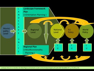
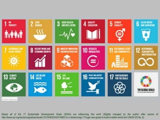
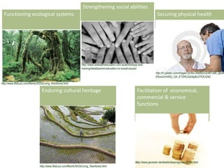
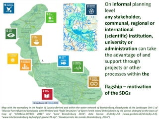
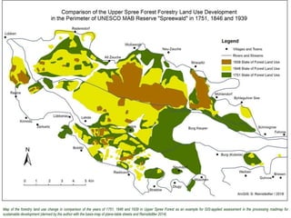
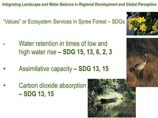
4. Nearly all of the 17 Sustainable Development Goals (SDGs) are influencing this work (Slightly changed by the author after source of:
http://www.npr.org/sections/goatsandsoda/ 2015/09/25/443149821/u-n-dreams-big-17-huge-new-goals-to-build-a-better-world and UNGA 2014a, b).
5. Source: slightly changed after https://www.youtube.com/watch?v=N2Ra2fp5De8; also compare https://www.theguardian.com/ science/video/2017/nov/18/its-a-delicate-place-nasa-captures-20-
years-of-earths-seasonal-changes-video
6. Source: slightly changed after https://www.youtube.com/watch?v=N2Ra2fp5De8; also compare https://www.theguardian.com/ science/video/2017/nov/18/its-a-delicate-place-nasa-captures-20-
years-of-earths-seasonal-changes-video
7. Facilitation of economical,
commercial & service
functions
http://www.gevestor.de/details/daxprognose-88496.html
Strengthening social abilities
http://www.wahealtheducation.com.au/workshops-and-
training/detail/parent-education-on-social-issues/
Securing physical health
http://t2.gstatic.com/images?q=tbn:ANd9GcQnW7u6B_0jbd4
EfzceUnrHNCj_GA_ET2lRLDqh4g8oCPCKJO62
Functioning ecological systems
http://www.filebuzz.com/fileinfo/5033/Living_Rainforest.html
Enduring cultural heritage
8. Source: slightly changed after https://www.youtube.com/watch?v=N2Ra2fp5De8; also compare https://www.theguardian.com/ science/video/2017/nov/18/its-a-delicate-place-nasa-captures-20-
years-of-earths-seasonal-changes-video
15. Map with the exemplary in the Region of Lusatia derived and within the water network of Brandenburg placed parts of the Landscape Unit 1 of
”Alluvial Fan Influenced Landscape with Wetland and Fließe Structures" of Spree Forest Inland Delta (drawn by the author, changed on the basis of
map of “GEOBasis-DE/BKG 2016” and "Land Brandenburg 2016”, data license: dl-de/by-2-0 (www.govdata.de/dl-be/by-2-0),
”www.mlul.brandenburg.de/lua/gis/ gewnet25.zip", “Gewässernetz des Landes Brandenburg, 2016”)
On informal planning
level
any stakeholder,
communal, regional or
international
(scientific) institution,
university or
administration can take
the advantage of and
support through
projects or other
processes within the
flagship – motivation
of the SDGs
16. Map of the forestry land use change in comparison of the years of 1751, 1846 and 1939 in Upper Spree Forest as an example for GIS-applied assessment in the processing roadmap for
sustainable development (derived by the author with the basis-map of plane-table sheets and Reinstädtler 2014)
18. “Values” or Ecosystem Services in Spree Forest – SDGs
• Water retention in times of low and
high water rise – SDG 15, 13, 6, 2, 3
• Assimilative capacity – SDG 13, 15
• Carbon dioxide absorption
– SDG 13, 15
Integrating Landscape and Water Balance in Regional Development and Global Perception
19. Lieberose Heath area (Foto sources: A+B: S. Reinstädtler, 27.05.2017, C+D: S. Reinstädtler. 03.10.2015)
A
C
D
B
20. Source: slightly changed after https://www.youtube.com/watch?v=N2Ra2fp5De8; also compare https://www.theguardian.com/ science/video/2017/nov/18/its-a-
delicate-place-nasa-captures-20-years-of-earths-seasonal-changes-video