SlideShare a Scribd company logo
1 of 11
Download to read offline
1
Table of Contents
Welcome Letter. .  .  .  .  .  .  .  .  .  .  .  .  .  .  .  .  .  .  .  .  .  .  .  .  .  .  .  .  .  .  .  .  .  .  .  .  .  .  .  .  . 2
Board of Directors / Planning Committee. .  .  .  .  .  .  .  .  .  .  .  .  .  .  .  .  .  .  .  .  . 3
Sponsoring Organizations .  .  .  .  .  .  .  .  .  .  .  .  .  .  .  .  .  .  .  .  .  .  .  .  .  .  .  .  .  .  .  .  . 4
Keynote Speakers.  .  .  .  .  .  .  .  .  .  .  .  .  .  .  .  .  .  .  .  .  .  .  .  .  .  .  .  .  .  .  .  .  .  .  .  .  . 6-7
Conference Program. .  .  .  .  .  .  .  .  .  .  .  .  .  .  .  .  .  .  .  .  .  .  .  .  .  .  .  .  .  .  .  .  .  . 8-11
The Cable Center Map – 1st Floor .  .  .  .  .  .  .  .  .  .  .  .  .  .  .  .  .  .  .  .  .  .  .  .  .  . 12
Exhibitor Booth Locator .  .  .  .  .  .  .  .  .  .  .  .  .  .  .  .  .  .  .  .  .  .  .  .  .  .  .  .  .  .  .  .  .  . 13
The Cable Center Map – 2nd Floor.  .  .  .  .  .  .  .  .  .  .  .  .  .  .  .  .  .  .  .  .  .  .  .  .  . 14
Poster Session / Social Event.  .  .  .  .  .  .  .  .  .  .  .  .  .  .  .  .  .  .  .  .  .  .  .  .  .  .  .  .  . 15
Post-Conference Tours.  .  .  .  .  .  .  .  .  .  .  .  .  .  .  .  .  .  .  .  .  .  .  .  .  .  .  .  .  .  .  .  .  .  . 16
COPYRIGHT
GIS in the Rockies Conference - Program volume 26
Copyright 2013 by GIS in the Rockies, Inc. All rights reserved
Published annually by GIS in the Rockies, P.O. Box 40885, Denver, Colorado 80204
The GIS in the Rockies conference program is distributed free to conference attendees.
GIS in the Rockies does not endorse or recommend any product or service that may
be cited, used or discussed in this publication or at the conference.
GIS and
Geomatics
at the University of Colorado Denver
Get more information at engineering.ucdenver.edu/gis
Contact us: Department of Civil Engineering, 303-556-2871
n	 Offering master of science, master of engineering,
graduate certificate and PhD programs
n	 Earn your degree entirely online
n	 Learn from acclaimed industry professionals
n	 Current courses cover:
GIS
GPS
Surveying
Lidar/HDS
Remote Sensing
32
Planning Committee Chair
Dave Watson, Boulder County
Secretary
Alison Gallensky, Rocky Mountain Wild
Chair Advisor
Bill Jeffrey, City of Westminster, RM-URISA
Marketing / Exhibits / Conference Planning
Paul Balaguer Events
Webmaster
Jonathan Harahush, MapQuest
Program Coordinators
Mike Johnsen, GISP,
Power Company of Wyoming LLC
Kerry Shakarjian, CSU/NPS
Registration Coordinators
Eli Crawley, Habitat Management, Inc.
Genie Hays, LizardTech
Volunteer Coordinator
Peggy Streicher, PLS, Denver Water, PLSC
Job Fair
Carolyn Ownby, Colorado State University
Nan Daniels, Nahada LLC
Student Breakfast
Elthron Anderson, GISP, Southgate Water and
Sanitation Districts, ASPRS-RMR
Poster Session
Steve Smith, GISP, City of Grand Junction
Vendor Showcase
Loren Pfau, EdgeConneX
Social Media
Kas Osterbuhr, Exosphere3D
Ethan Crawford, University of Denver
Database
Elissa Adams, GISP, CH2M Hill, RM-URISA
Outreach
Tillman Saylor, MapMart, ASPRS-RMR
Social Activities
Brandi Rank, GISP, Adams County
Signs
Heather Lassner, LSI, City of Loveland, PLSC
Workshop Coordinators
Carson Coates, S.M. Stoller Corporation, GISCO
Bill Jeffrey, City of Westminster, RM-URISA
Tours Coordinator
Barb Wolf, Denver Water, RM-URISA
Society Representatives
Nathan Lowry, Governor’s Office of Information
Technology, GISCO
Niki Noon, ASPRS-RMR
Master of Ceremonies
Dave Watson, Boulder County
Welcome
Hello and welcome to the 26th annual GIS in the Rockies conference, 2013!
Since its inception in Ft. Collins, CO in 1989, GIS in the Rockies has brought together a
veritable cornucopia of leading professionals from an array of industries, government
entities and varied disciplines. Another way of stating it is that this conference has
brought you together. Your knowledge, expertise, skills, genius and professionalism
perpetually make the conference a success.
This year demonstrates how much you and your colleagues want to participate in the
conference as well as glean from the benefits of industry successes and collaboration.
We have over 100 sessions and poster presentations, not to mention two dynamic
keynote speakers well rooted in the geospatial arena. Let’s also celebrate all of the
individuals who have volunteered their time to bring you the best possible conference.
As you know, the geospatial field is ever growing, ever changing, and propelling
forward. This year we will build this core discipline by strengthening our foundation
locally, while improving our understanding of its impact on a global scale. As
individuals, companies, non-profit organizations, and government entities advance
geospatial information by pushing and stretching it throughout familiar areas and into
uncharted territories, so goes
the art of GIS itself. Together we will keep geospatial on the move.
Dave Watson
Planning Committee Chair
2013 Board of Directors
President	 Bill Jeffrey, City of Westminster, RM-URISA
Vice-President	 Mark Stanton, CP, Premier Geospatial, Inc., President, ASPRS-RMR
Secretary	 Kayce Keane, PLS, Walsh Environmental, PLSC
Treasurer	 Darcee Killpack, National Park Service, GISCO
Member Society Alternate	 Elissa Adams, GISP, CH2M Hill, RM-URISA
Member Society Alternate	 Jeffrey M. Young, LizardTech, ASPRS-RMR National Director
Member at Large	 Emily Nichols, Jeppesen
Planning Committee
54
GIS Colorado (also known as “GISCO”) is a statewide grass-roots
organization providing a cooperative environment of GIS users from
both public and private sectors. The primary goal of GIS Colorado
is to foster communication and education to advance the level of effectiveness of GIS use in
Colorado. The group maintains a list-server, and hosts educational events and quarterly forums
on various GIS topics in different parts of Colorado to encourage learning and data sharing.
www.giscolorado.com
URISA is an interdisciplinary society dedicated to stimulating
and encouraging the effective integration and application of
information technology and urban and regional information for
decision-making. A nonprofit educational association, URISA provides a forum for users of spatial
information in both the public and private sectors. Founded in 1982, RM/URISA is a regional
chapter serving the Rocky Mountain area, including the states of Colorado, New Mexico, Utah
and Wyoming. www.urisa.org
ASPRS The Imaging and Geospatial Information Society. ASPRS, founded
in 1934, is a scientific association serving over 7,000 professional
members around the world. Our mission is to advance knowledge and
improve understanding of mapping sciences to promote the responsible
applications of photogrammetry, remote sensing, GIS, and supporting geotechnologies. ASPRS
members work in a variety of disciplines from education and engineering to aerospace and
agriculture. The Rocky Mountain Region serves ASPRS members in Montana, Wyoming, Colorado,
and New Mexico. www.asprs.org
PLSC is a non-profit organization dedicated to the improvement of land
surveying education and practice throughout Colorado. PLSC offers
members an exciting and interactive environment to grow and develop
their land survey skills and abilities. www.plsc.net
Sponsoring Organizations
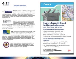
REDUCE ERRORS AND INCREASE PROFITABILITY
• Improve communication within project teams
• Gain fast access to high quality printed maps
• Print and distribute up-to-the-minute maps quickly
• Experience easy job submission and powerful large-file processing
THE OCÉ COLORWAVE 650 PRINTER DELIVERS
BIG BENEFITS
• Fast, easy, no-mess toner printing—up to 1,300 sq. ft./hour
• Instantly usable, water fast prints—zero drying time
• Six available media rolls allows GIS users the flexibility to print
without time-consuming roll changes
Improve Productivity and
End Printer Bottlenecks
Océ ColorWave®
650 Printer
For more information, call 1-800-714-4427,
email: us.info@csa.canon.com, or visit www.csa.canon.com
©2013 Canon Solutions America, Inc. All rights reserved.
76
James Fee is owner and founder of Spatially Adjusted. He has been working in the
geospatial industry for almost 20 years as a consultant, programmer, manager and
user. James has blogged about GIS for over 8 years at spatiallyadjusted.com where he
comments frequently on the state of geospatial technology, trends, and baseball. His
blog is one of the most widely read online publications about GIS. He also founded
Planet Geospatial, a GIS news aggregator, to share and promote geospatial technology.
James’ current focus is on GeoDesign and how geospatial concepts can help humans
protect and improve the world around them by building with nature instead of against
it. His focus is on open technologies that can be applied across disciplines and
platforms so that anyone can take advantage of GIS. James has been involved with
Esri, open source projects, OpenStreetMap, as well as humanitarian GIS initiatives.
James speaks and teaches regularly at conferences around the world.
Keynote Speaker
James Fee
Frank Biasi is the Director of Digital Development for National Geographic Maps
in Evergreen, Colorado, where he produces websites, maps and apps focused
on environmental conservation and sustainability. He has managed geospatial
programs in the nonprofit and public sectors for over 20 years, conducting GIS
and mapping projects at local, state, national and global scales. Prior to joining
National Geographic in 2006, he worked for The Nature Conservancy (TNC) as a
Regional GIS Manager, Enterprise GIS Manager and Director of Conservation Systems
where he led the diffusion of GIS across the organization and its integration with
the organization’s IT infrastructure. Prior to TNC he worked for the Massachusetts
Department of Environmental Protection where he managed the development of a
statewide wetlands database and digital orthophoto mapping program.
He is a past president of the Society for Conservation GIS and a member of the IUCN
World Commission on Protected Areas. He holds a Bachelor’s degree in Geography
and Art from Clark University and a Master’s in Environment from Duke University.
He is currently focused on the integration of maps, multimedia and storytelling
to raise awareness and understanding of environmental issues and promote
sustainable travel and tourism. His current projects include EnergyRealities.org,
EnvisiontheJames.org and GeoStories.org, as well as a forthcoming multimedia atlas
for the Colorado River Basin.
Keynote Speaker
Frank Biasi
98
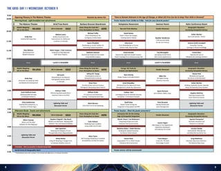
The Malone Theater ACA/Triax Room Barbara Bresnan Boardroom Delaplaine Newsroom Saeman Room Kahn Conference Room
Mobile Mapping:
GIS on the Move
GIS in Colorado
Views Along the Scale Bar:
From Hemisphere to Home
Tips and Tricks Mashup Vendor Showcase
Geographic Education:
Increasing Geospatial Literacy
Mobile Mapping:
GIS on the Move
GIS in Colorado
Views Along the Scale Bar:
From Hemisphere to Home
Energy: GIS Tools for
Analysis and Optimization
Vendor Showcase
Geographic Education:
Increasing Geospatial Literacy
Mobile Mapping:
GIS on the Move
GIS in Colorado
Views Along the Scale Bar:
From Hemisphere to Home
Enterprise GIS: On the Cutting
Edge of Geospatial Integration
Vendor Showcase
Geographic Education:
Increasing Geospatial Literacy
Opening Plenary in The Malone Theater Keynote by James Fee "How to Remain Relevant in the Age of Change, or What GIS Pros Can Do to Keep Their Skills in Demand"
Morning Break - Light breakfast and refreshments Poster Session from 10:00a to 5:00p - Vote for your favorite poster!
Andy Gup
Android GPS Deep Dive
Nathan Lowry
Quality Assessment and
Improvement for Addressed
Locations in Colorado
Michael Tuffly
Ozone Modeling for the
Contiguous United States
David Haines
Make it Work Like Google:
Creating Search Indexes Heather Henderson
A GIS Survival Guide
for the 21st Century
Esther Worker
Don’t Just Survive…Thrive!
Break
Aymn Elhaddad
Developing an ArcGIS Toolbox for
Estimating Evapotranspiration
Zeke Houk
From ModelBuilder to Formal
Python Code, Step-by-Step
Victoria Smith-Campbell
Accessible Training -
Leverage In-House Knowledge
Alex Mahrou
Synchronize Your
Mobile Enterprise
Adam Hoppe | Pete Coventry
Using GIS to Help Appraisal
Staff Value Property
Kathleen Johnson
Monitoring Ponderosa Pine Health
Using Satellite Imagery
Grant Garstka
Beyond the Legitimate Dangle Impasse:
Export Topology Errors Geoprocessing Tool
Trip McLaughlin
Leveraging ArcGIS Online
with Custom Applications
Emma Giles
Opening the Eyes of
Collegiate Microbiology Students
Break Break Break
Quint Pertzsch
GIS is Where. OMS is How.
Scott Stafford-Veale
Deploying Web-GIS Apps
on Multiple Platforms
William Gribb
3-D Land Use and Downtown
Parking: Creating Demand Index
Lindsey Hart
Leveraging GIS Across Multiple Business
Disciplines: A Petroleum Example
Stephen McElroy
Teaching Enterprise GIS:
From Theory to Practice
Andy Gup
Kickstarter for JavaScript Web
and Mobile GIS Development
Bill Smith
Stewardship of the National
Hydrography Dataset (NHD)
in Colorado
Jeffrey M. Young
Contemporary Issues in
Geospatial Data Archiving
Ryan Hennig
Design Analysis and Optimization
Mike Cho
GE Digital Energy
Solutions Overview
Steven Hick
Blended Learning and
the Future of GIS Education
Brian Penn
The Role of the Land Use Analysis
Package for Generating Data Products
Amol Kitwadkar
GIS-Based Tool for Optimized Fluids
Management in Shale Gas Operations
Esther Worker
Building a Spatially Literate, Spatially
Savvy and Spatially Active Student
Kathryn Yoder
Referencing Nationwide Rivers
Inventory Data to the NHD
Lightning Talks and
Discussion Forum
Afternoon Break - Snacks and refreshments Poster Session - Meet the poster presenters!
Mitch Tweedy
What is All This New
Software for GPS Mapping?
Stephen Chignell | Sky Skach
Wildfire and Wetlands: Mapping with
LANDSAT, GIS, and Statistical Models
Colin Hobson
Modeling Asset Condition
Using LIDAR and GIS data
Nicole Peace | Ian McGovern
Integrating People and Tools:
Enterprise GIS Success Stories Jayson Hagen
New Ready-to-Use Applications:
Operations Dashboard
and Collector for ArcGIS
Apostol Panayotov
Geomatic Education and
Research in Colorado
Lightning Talks and
Discussion Forum
Chris Leatherman
Reading Retroreflectivity, an
Inventory of Street Signs
Lightning Talks and
Discussion Forum
Mark McLean
Time Until Fire Arrival Modeling
Geoff Zeiss
Global Trends Driving the
Integration of Geospatial and BIM
Chris Brussow
Getting Started with
Asset Management
Seth Spielman
Reducing ACS Margins of Error
Through Data-Driven Regionalization
Matthew Baker | Robb Menzies
Building the Spatial Enterprise
for Denver Public Schools
Carolyn Ownby
AmericaView: Who We Are
and What We Can Do for You
Alicia Tyson
GIS Prototype Modeling of Landslide
Susceptibility and Risk Perception
Molly Molter
Using 3D Modeling in Google Earth
to Evaluate Visibility Concerns
Dennis Beck
Using Spatial ETL in a Multi-Vendor
Enterprise GIS Environment
Trent Meyers
Inside GIS: The Next
Technology Frontier
Greg Matthews
Volunteer Map Data Collection -
The National Map Corps
Transition - time to socialize in Daniels Great Hall
Social Event & Geography Quiz! Poster winner will be announced!
* Presentation time slots include 5-10 minutes for Q&A plus a 5-minute transition
RM URISA
Lunch is Available
10:30
11:00
10:00
8:30
RmTrack
11:30
12:00
1:00
1:30
2:00
4:00
4:30
5:00
Track
3:30
6:30
2:30
3:00
Track
RM URISA GISCO ASPRS
ASPRSGISCORM URISA
GISCO ASPRS
Lunch is Available
THE GRID: Day 1 | Wednesday, October 9
1110
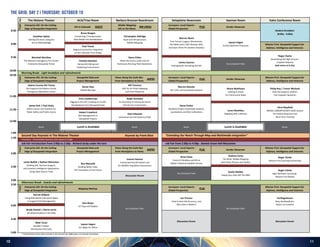
The Malone Theater ACA/Triax Room Barbara Bresnan Boardroom Delaplaine Newsroom Saeman Room Kahn Conference Room
Enterprise GIS: On the Cutting
Edge of Geospatial Integration
GIS in Colorado
Mobile Mapping:
GIS on the Move
Surveyors: Local Experts -
Global Perspective
Vendor Showcase
Enterprise GIS: On the Cutting
Edge of Geospatial Integration
Geospatial Data and
Project Management
Views Along the Scale Bar:
From Hemisphere to Home
Surveyors: Local Experts -
Global Perspective
Vendor Showcase
Mission First: Geospatial Support for
Defense, Intelligence and Veterans
Enterprise GIS: On the Cutting
Edge of Geospatial Integration
Geospatial Data and
Project Management
Views Along the Scale Bar:
From Hemisphere to Home
Surveyors: Local Experts -
Global Perspective
Vendor Showcase
Mission First: Geospatial Support for
Defense, Intelligence and Veterans
Enterprise GIS: On the Cutting
Edge of Geospatial Integration
Mapping Mashup
Surveyors: Local Experts -
Global Perspective
Mission First: Geospatial Support for
Defense, Intelligence and Veterans
Student Breakfast
(8:00a - 9:00a)
Jonathan Spitze
Getting GIS Done Using the
Scrum Methodology
Bruce Reagan
Converting a Transportation
Data Model into Geodatabase
Christopher Aldridge
Asset and Infrastructure
Mobile Mapping
Warren Ward
Four Corners Legacy: Monuments,
Not Math (and 1,001 Reasons Why
Surveyors Plant Pin Gardens Anyway)
Jayson Hagen
ArcGIS GeoEvent Processor Mission First: Geospatial Support for
Defense, Intelligence and Veterans
Paul Tessar
Regional Centerline Integration
on the Colorado Front Range
Marshall Worthey
The National Interagency Fire Center
Enterprise Geospatial Portal
Steve Chiles
What the Future Looks Like for
Businesses Running Fleet Operations
Roger Clarke
Dominating the High Ground -
A Spatial Odyssey
(talk starts at 9:15a)
Pamela Hanstein
DenverGIS Editing and
Publishing Environment
Carlos Caceres
Hydrographic Surveying and GIS
No Scheduled Talks
Morning Break - Light breakfast and refreshments
Philip Roy | Trevor Weiland
How GIS Supports USAFA's
Civil Engineer Squadron
James Kelt | Paul Healy
Delta County’s GIS Solution for
Public Safety and Public Access
Chris Leatherman
Digging in the Dirt: Creating an ArcGIS
Geodatabase from Nonspatial Data
Ralph Vomaske
An Overview of Unmanned Aerial
Vehicle Use in Geomatics Steve Parker
Modified Project Coordinate Systems,
Localizations and Site Calibrations
Adams County GIS Teams
GIS Supports the Adams County
Emergency Operations Center
Genie Hays
Mobile Big Data
Bill Timmins
UAV for Air Photo Mapping
and Event Response
Warren Geissler
GIS, CAD, and Coordinate Systems
Shane Matthews
Getting to Know
Esri Community Maps
Loren Muehlius
Mapping with a Mission
Chris Mayfield
NORAD-USNORTHCOM'S SAGE System
for Federal Response and
Blue Force Tracking
Robert Crawford
Risk Management in
Geospatial Projects
Zach Edwards
Unmanned Aircraft Systems (UAS)
Break
Second Day Keynote in The Malone Theater Keynote by Frank Biasi "Extending Our Reach Through Map and Multimedia Integration"
Transition - Presentation Sessions start again at 2:00p
Break Break Break
Job Fair Introduction from 2:00p to 2:30p - Richard Serby under the tent Job Fair from 2:30p to 4:30p - Daniels Great Hall Mezzanine
Roger Clarke
Mission First Learning Partnership
No Scheduled Talks
Austin Mulder
Taking Your Data Off The GRID
Roger Clarke
High-Definition Surveying -
Mission First RealityDiscussion Forum
Justin Naifeh | Nathan McEachen
Building GIS, Decision Support,
and Location Intelligence Applications
Using Open Source Tools
Ben Metcalfe
Building Better Data:
The Foundation of the Future
Leanne Hanson
Unmanned Aircraft System Use
for Wildlife Population Assessment
Brian Shaw
Fusion of Geodesy and GIS at
NOAA’s National Geodetic Survey
Andrew Carey
TerraFlex: Mobile Mapping
with Smart Phones and Tablets
Discussion Forum
Matt Taran
Boulder's Water
Distribution Info Suite
Jayson Hagen
Esri Maps for Office
* Presentation time slots include 5-10 minutes for Q&A plus a 5-minute transition
Afternoon Break - Snacks and refreshments
No Scheduled Talks No Scheduled Talks
Darcee Killpack
Using Web-Based Interactive Maps
to Support Park Management
Sara Boyer
US Topo and Maplex
Jon Proctor
How to Describe Accuracy, and
Why Does It Matter?
Ed Riegelmann
Navy GeoReadiness:
Return on Location
Brady Hustad | Cherie Jarvis
3D Spatial Analysis in the Web
Discussion Forum
10:30
11:00
8:30
RmTrack
11:30
12:00
1:00
2:30
3:00
4:00
4:30
5:00
Track
2:00
1:50
9:00
9:30
10:00
3:30
GISCO RM URISA PLSC
Lunch is Available Lunch is Available
TrackTrack
PLSCASPRS
ASPRS PLSC
PLSC
THE GRID: Day 2 | Thursday, October 10
1312
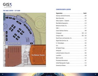
Exhibitor Booth Locator
Organization. . . . . . . . . . . . . . . . . . . . . . . . . . . . . . . . . . . Booth
American Sentinel University.  .  .  .  .  .  .  .  .  .  .  .  .  .  .  .  .  .  .  .  .  .  .  .  . 104
Ayres Associates. .  .  .  .  .  .  .  .  .  .  .  .  .  .  .  .  .  .  .  .  .  .  .  .  .  .  .  .  .  .  .  .  .  . 123
Azteca Systems - Cityworks.  .  .  .  .  .  .  .  .  .  .  .  .  .  .  .  .  .  .  .  .  .  .  .  .  . 122
Blue Marble Geographics.  .  .  .  .  .  .  .  .  .  .  .  .  .  .  .  .  .  .  .  .  .  .  .  .  .  .  . 119
Bohannan Huston, Inc.. .  .  .  .  .  .  .  .  .  .  .  .  .  .  .  .  .  .  .  .  .  .  .  .  .  .  .  .  . 111
CAD-1. . . . . . . . . . . . . . . . . . . . . . . . . . . . . . . . . . . . . . . . . . 117
Canon Solutions America.  .  .  .  .  .  .  .  .  .  .  .  .  .  .  .  .  .  .  .  .  .  .  .  .  .  .  . 108
Cartegraph .  .  .  .  .  .  .  .  .  .  .  .  .  .  .  .  .  .  .  .  .  .  .  .  .  .  .  .  .  .  .  .  . 109 - 110
Compass Tools.  .  .  .  .  .  .  .  .  .  .  .  .  .  .  .  .  .  .  .  .  .  .  .  .  .  .  .  .  .  . 102 - 103
David Evans and Associates, Inc.. . . . . . . . . . . . . . . . . . . . . 114
Digital Data Services, Inc..  .  .  .  .  .  .  .  .  .  .  .  .  .  .  .  .  .  .  .  .  .  .  .  .  .  . 112
E.I. Technologies. . . . . . . . . . . . . . . . . . . . . . . . . . . . . . . . . . 105
Esri. . . . . . . . . . . . . . . . . . . . . . . . . . . . . . . . . . . . . . . . . . . . 101
GE Digital Energy.  .  .  .  .  .  .  .  .  .  .  .  .  .  .  .  .  .  .  .  .  .  .  .  .  .  .  .  .  .  .  .  .  . 113
Intergraph.  .  .  .  .  .  .  .  .  .  .  .  .  .  .  .  .  .  .  .  .  .  .  .  .  .  .  .  .  .  .  .  .  .  .  .  .  .  . 121
Latitude Graphics Group Ltd..  .  .  .  .  .  .  .  .  .  .  .  .  .  .  .  .  .  .  .  .  .  .  .  . 106
LizardTech.  .  .  .  .  .  .  .  .  .  .  .  .  .  .  .  .  .  .  .  .  .  .  .  .  .  .  .  .  .  .  .  .  .  .  .  .  .  . 118
North Line GIS .  .  .  .  .  .  .  .  .  .  .  .  .  .  .  .  .  .  .  .  .  .  .  .  .  .  .  .  .  .  .  .  .  .  .  . 116
Pictometry International. .  .  .  .  .  .  .  .  .  .  .  .  .  .  .  .  .  .  .  .  .  .  .  .  .  .  .  . 107
United Reprographic Supply. .  .  .  .  .  .  .  .  .  .  .  .  .  .  .  .  .  .  .  .  .  .  .  .  . 115
University of Denver.  .  .  .  .  .  .  .  .  .  .  .  .  .  .  .  .  .  .  .  .  .  .  .  .  .  .  .  .  .  .  . 120
101 102
103
104
105
106
107
108
109
110
112
111
113
114
116
115
119
120
117
118
121122123
SIGN
IN
Guest Entrance
THE Cable Center - 1st Floor
Daniels Great Hall
The Malone Theater
1514
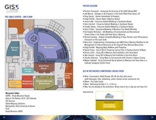
THE Cable Center - 2nd Floor
The Malone
Theater
Balcony
MezzanineTables
POSTER SESSION
• Kristina Yamamoto - Assessing the Accuracy of the USGS Alaska NHD
• Joel Murray - Changes in AG Irrigation in the South Platte River Basin, CO
• Doug Genzer - Denver Amendment 64 Analysis
• Diego Portillo - Denver Water Collection System
• Jamie Fuller - Estuarine Habitat Modeling in Southeast Alaska
• Sam Litschert - Estuarine Habitat Modeling in Southeast Alaska
• Carolyn Ownby - Estuarine Habitat Modeling in Southeast Alaska
• Aaron Sidder - Geospatial Modeling of Mountain Pine Beetle Mortality
• Christopher Nicholson - GIS Modeling of Environmental and Recreational
Stream Flows in the Snake-Salt River Basin, Wyoming
• Rachel Granberg - Habitat Suitability Modeling of Texas Horned Lizard (Phrynosoma
Cornutum) at the Local Scale
• Kerry Gaiz - Implementing a Geodatabase and GNSS Data Collection Workflow for the
Management of Cultural Resources at the Flagstaff Area National Monuments
• Diego Portillo - Mapping Major Wildfires with Properties
• Kamal Thapa - Use of GIS for Preparing Tourism Plan in Pyuthan District of Nepal
• Briana Carlin - Using GIS to Measure Soil Erodibility in the Uinta Basin
• Alex Leonard - Using GIS to Measure Soil Erodibility in the Uinta Basin
• Charles Osterman - Using Maps to Communicate with Citizens in Adams County
• Megan Caldwell - Using Unmanned Aerial Systems to Measure Leaf Area Index in a
Colorado Subalpine Conifer Forest
GIS IN THE ROCKIES CONFERENCE SOCIAL EVENT
• What: Camaraderie, World Renown GIS itR Geo Quiz with prizes,
adult beverages, food, networking, poster session winner announced, etc.
• Where: The Cable Center
• When: 	Wednesday October 9, 5 - 6:30 p.m.
• Why: You are already at the conference. All you have to do is stay put and have fun!
Sponsored by:
Mezzanine Tables
ASPRS - Rocky Mountain Region
GeCo In The Rockies 2014 / GIS Colorado
GIS Services
Global Mapping Solutions
Metropolitan State University of Denver
PLSC
Rocky Mountain URISA
1716
MetCom (Metropolitan Area Communication
Center): 911, Fire, EMS
	 The Metropolitan Area Communications Center
(MetCom) was designed to serve as a regional Fire/
EMS emergency communications center committed
to outstanding patient care, exceptional customer
service and improved call handling performance.
	 GIS works in conjunction with MetCom’s
Computer Aided Dispatch (CAD) to display
geographic information on a computerized map of
our district and surrounding districts for mutual aid.
The location of 911 calls made from landline phones
displays on the map, as does the general location
of cell phone callers who have Phase II compliant
phones. Our data includes detailed information to
the firefighter or paramedic in the field. Available
data includes but is not limited to: hydrant data,
addresses, water mains, trails, rivers, driveways,
aerial photography, plus more. The highly accurate
data for the GIS mapping used by CAD is maintained
internally with dedicated staff to provide the most
up-to-date information possible.
NREL (National Renewable Energy Laboratory)
	 The National Renewable Energy Laboratory
(NREL) is the U.S. Department of Energy’s primary
national laboratory for renewable energy and
energy efficiency research and development. NREL
develops renewable energy and energy efficiency
technologies and practices, advances related
science and engineering, and transfers knowledge
and innovations to address the nation’s energy and
environmental goals.
	 As the nation’s leading center for renewable
energy research, NREL is developing new energy
technologies to benefit both the environment and
the economy. Visitors learn about energy from the
sun, wind, biomass, hydrogen, and other sources of
renewable energy. Find out how scientists capture
alternative energy resources to produce electricity
and fuels. Investigate advanced vehicles. Explore
NREL’s sustainable “Campus of the Future” using an
interactive digital display. Outside, see utility-scale
wind turbine components and learn more about
small-scale wind and solar power in your yard.
POST CONFERENCE TOURS
2014
Grand Junction, Colorado
September 22-26, 2014
Joint Conference
gecointherockies.org

More Related Content

What's hot

Going Mobile with HTML5
Going Mobile with HTML5Going Mobile with HTML5
Going Mobile with HTML5John Reiser
 
Cabaret of Dangerous Ideas Presentation on FieldTrip GB
Cabaret of Dangerous Ideas Presentation on FieldTrip GBCabaret of Dangerous Ideas Presentation on FieldTrip GB
Cabaret of Dangerous Ideas Presentation on FieldTrip GBEDINA, University of Edinburgh
 
IoT Meets Geo
IoT Meets GeoIoT Meets Geo
IoT Meets GeoRaj Singh
 
ForksGIS - Continuing to Grow
ForksGIS - Continuing to GrowForksGIS - Continuing to Grow
ForksGIS - Continuing to Growfireflytza
 
Exploring Community Engagement with OpenTreeMap
Exploring Community Engagement with OpenTreeMapExploring Community Engagement with OpenTreeMap
Exploring Community Engagement with OpenTreeMapAzavea
 

What's hot (7)

Going Mobile with HTML5
Going Mobile with HTML5Going Mobile with HTML5
Going Mobile with HTML5
 
Geospatial Tech in Teaching
Geospatial Tech in TeachingGeospatial Tech in Teaching
Geospatial Tech in Teaching
 
Cabaret of Dangerous Ideas Presentation on FieldTrip GB
Cabaret of Dangerous Ideas Presentation on FieldTrip GBCabaret of Dangerous Ideas Presentation on FieldTrip GB
Cabaret of Dangerous Ideas Presentation on FieldTrip GB
 
IoT Meets Geo
IoT Meets GeoIoT Meets Geo
IoT Meets Geo
 
ForksGIS - Continuing to Grow
ForksGIS - Continuing to GrowForksGIS - Continuing to Grow
ForksGIS - Continuing to Grow
 
Exploring Community Engagement with OpenTreeMap
Exploring Community Engagement with OpenTreeMapExploring Community Engagement with OpenTreeMap
Exploring Community Engagement with OpenTreeMap
 
Developing a Crowd Sourcing App
Developing a Crowd Sourcing AppDeveloping a Crowd Sourcing App
Developing a Crowd Sourcing App
 

Viewers also liked

2016 web mapping track: development of an arc gis online web application for...
2016 web mapping track: development of an arc gis online  web application for...2016 web mapping track: development of an arc gis online  web application for...
2016 web mapping track: development of an arc gis online web application for...GIS in the Rockies
 
Integrar Tecnología Smart Water en ArcGIS : Gestión de Activos con InfoMaster...
Integrar Tecnología Smart Water en ArcGIS : Gestión de Activos con InfoMaster...Integrar Tecnología Smart Water en ArcGIS : Gestión de Activos con InfoMaster...
Integrar Tecnología Smart Water en ArcGIS : Gestión de Activos con InfoMaster...Esri España
 
Catálogo de Áreas de Actividad Económica de Navarra (cAAE), usando Web AppBui...
Catálogo de Áreas de Actividad Económica de Navarra (cAAE), usando Web AppBui...Catálogo de Áreas de Actividad Económica de Navarra (cAAE), usando Web AppBui...
Catálogo de Áreas de Actividad Económica de Navarra (cAAE), usando Web AppBui...Esri España
 
Seeing Smart cities through a Geospatial Lens
Seeing Smart cities through a Geospatial Lens Seeing Smart cities through a Geospatial Lens
Seeing Smart cities through a Geospatial Lens Tarik Dixon, GISP
 
Esri smart solutions para smart communities - Conferencia Esri 2016
Esri smart solutions para smart communities - Conferencia Esri 2016Esri smart solutions para smart communities - Conferencia Esri 2016
Esri smart solutions para smart communities - Conferencia Esri 2016Esri España
 
InO Add-In: caminos forestales y segmentación dinámica - Conferencia Esri 2016
InO Add-In: caminos forestales y segmentación dinámica - Conferencia Esri 2016InO Add-In: caminos forestales y segmentación dinámica - Conferencia Esri 2016
InO Add-In: caminos forestales y segmentación dinámica - Conferencia Esri 2016Esri España
 
A geospatial approach to analyzing real estate values - Case Study: King's Cr...
A geospatial approach to analyzing real estate values - Case Study: King's Cr...A geospatial approach to analyzing real estate values - Case Study: King's Cr...
A geospatial approach to analyzing real estate values - Case Study: King's Cr...Tarik Dixon, GISP
 
2016 asprs track: considering a uav: now what? by jeff young
2016 asprs track: considering a uav: now what? by jeff young2016 asprs track: considering a uav: now what? by jeff young
2016 asprs track: considering a uav: now what? by jeff youngGIS in the Rockies
 
Applications of RS and GIS in Urban Planning by Rakshith m murthy
Applications of RS and GIS in Urban Planning by Rakshith m murthyApplications of RS and GIS in Urban Planning by Rakshith m murthy
Applications of RS and GIS in Urban Planning by Rakshith m murthys0l0m0n7
 
Gis technology Application in Urban Planning in Kenya - Mathenge Mwehe
Gis technology Application in Urban Planning in Kenya - Mathenge MweheGis technology Application in Urban Planning in Kenya - Mathenge Mwehe
Gis technology Application in Urban Planning in Kenya - Mathenge MweheMathenge Mwehe
 
GIS in property management
GIS in property management GIS in property management
GIS in property management Samuel Dekolo
 
What is GIS
What is GISWhat is GIS
What is GISEsri
 

Viewers also liked (14)

2016 web mapping track: development of an arc gis online web application for...
2016 web mapping track: development of an arc gis online  web application for...2016 web mapping track: development of an arc gis online  web application for...
2016 web mapping track: development of an arc gis online web application for...
 
EOC Study
EOC StudyEOC Study
EOC Study
 
Integrar Tecnología Smart Water en ArcGIS : Gestión de Activos con InfoMaster...
Integrar Tecnología Smart Water en ArcGIS : Gestión de Activos con InfoMaster...Integrar Tecnología Smart Water en ArcGIS : Gestión de Activos con InfoMaster...
Integrar Tecnología Smart Water en ArcGIS : Gestión de Activos con InfoMaster...
 
Catálogo de Áreas de Actividad Económica de Navarra (cAAE), usando Web AppBui...
Catálogo de Áreas de Actividad Económica de Navarra (cAAE), usando Web AppBui...Catálogo de Áreas de Actividad Económica de Navarra (cAAE), usando Web AppBui...
Catálogo de Áreas de Actividad Económica de Navarra (cAAE), usando Web AppBui...
 
Seeing Smart cities through a Geospatial Lens
Seeing Smart cities through a Geospatial Lens Seeing Smart cities through a Geospatial Lens
Seeing Smart cities through a Geospatial Lens
 
Esri smart solutions para smart communities - Conferencia Esri 2016
Esri smart solutions para smart communities - Conferencia Esri 2016Esri smart solutions para smart communities - Conferencia Esri 2016
Esri smart solutions para smart communities - Conferencia Esri 2016
 
InO Add-In: caminos forestales y segmentación dinámica - Conferencia Esri 2016
InO Add-In: caminos forestales y segmentación dinámica - Conferencia Esri 2016InO Add-In: caminos forestales y segmentación dinámica - Conferencia Esri 2016
InO Add-In: caminos forestales y segmentación dinámica - Conferencia Esri 2016
 
A geospatial approach to analyzing real estate values - Case Study: King's Cr...
A geospatial approach to analyzing real estate values - Case Study: King's Cr...A geospatial approach to analyzing real estate values - Case Study: King's Cr...
A geospatial approach to analyzing real estate values - Case Study: King's Cr...
 
2016 asprs track: considering a uav: now what? by jeff young
2016 asprs track: considering a uav: now what? by jeff young2016 asprs track: considering a uav: now what? by jeff young
2016 asprs track: considering a uav: now what? by jeff young
 
Applications of RS and GIS in Urban Planning by Rakshith m murthy
Applications of RS and GIS in Urban Planning by Rakshith m murthyApplications of RS and GIS in Urban Planning by Rakshith m murthy
Applications of RS and GIS in Urban Planning by Rakshith m murthy
 
Gis technology Application in Urban Planning in Kenya - Mathenge Mwehe
Gis technology Application in Urban Planning in Kenya - Mathenge MweheGis technology Application in Urban Planning in Kenya - Mathenge Mwehe
Gis technology Application in Urban Planning in Kenya - Mathenge Mwehe
 
GIS in property management
GIS in property management GIS in property management
GIS in property management
 
Gis in urban
Gis in urbanGis in urban
Gis in urban
 
What is GIS
What is GISWhat is GIS
What is GIS
 

Similar to 2013 GISitR Program

Arvada_revised-1-201403201430
Arvada_revised-1-201403201430Arvada_revised-1-201403201430
Arvada_revised-1-201403201430Rose D Chávez
 
Open Green Map Introduction
Open Green Map IntroductionOpen Green Map Introduction
Open Green Map IntroductionGreen Map System
 
Esri Solutions for Water Resources Management
Esri Solutions for Water Resources ManagementEsri Solutions for Water Resources Management
Esri Solutions for Water Resources ManagementEsri
 
ama_public_input_toolkit_Sept2014
ama_public_input_toolkit_Sept2014ama_public_input_toolkit_Sept2014
ama_public_input_toolkit_Sept2014Cathy Clarke
 
Introduction to OpenStreetMap, its extracts, and relation to Project NOAH
Introduction to OpenStreetMap, its extracts, and relation to Project NOAHIntroduction to OpenStreetMap, its extracts, and relation to Project NOAH
Introduction to OpenStreetMap, its extracts, and relation to Project NOAHErvin Malicdem
 
Maple Crossing Strategic Plan
Maple Crossing Strategic Plan Maple Crossing Strategic Plan
Maple Crossing Strategic Plan Keelee Slack
 
Great Places 2020 Maple Crossing Full Strategic Plans
Great Places 2020 Maple Crossing Full Strategic PlansGreat Places 2020 Maple Crossing Full Strategic Plans
Great Places 2020 Maple Crossing Full Strategic PlansKeelee Slack
 
2016 0510 gp-maple-crossing-final-web-min
2016 0510 gp-maple-crossing-final-web-min2016 0510 gp-maple-crossing-final-web-min
2016 0510 gp-maple-crossing-final-web-minKeelee Slack
 
RCE Saskatchewan Mobilization through Virtual Communication and Policy Platforms
RCE Saskatchewan Mobilization through Virtual Communication and Policy PlatformsRCE Saskatchewan Mobilization through Virtual Communication and Policy Platforms
RCE Saskatchewan Mobilization through Virtual Communication and Policy PlatformsESD UNU-IAS
 
Regional planning agency overview
Regional planning agency overviewRegional planning agency overview
Regional planning agency overviewjbridger89
 
Cincinnati Tableau User Group Event #8 (Mapping)
Cincinnati Tableau User Group Event #8 (Mapping)Cincinnati Tableau User Group Event #8 (Mapping)
Cincinnati Tableau User Group Event #8 (Mapping)Russell Spangler
 
Travis Frank Portfolio 2016
Travis Frank Portfolio 2016Travis Frank Portfolio 2016
Travis Frank Portfolio 2016Travis Frank
 
GIS for Everyone
GIS for EveryoneGIS for Everyone
GIS for EveryoneEsri
 

Similar to 2013 GISitR Program (20)

Arvada_revised-1-201403201430
Arvada_revised-1-201403201430Arvada_revised-1-201403201430
Arvada_revised-1-201403201430
 
Open Green Map Introduction
Open Green Map IntroductionOpen Green Map Introduction
Open Green Map Introduction
 
RiverFirst Vision (Final 2012)
RiverFirst Vision (Final 2012)RiverFirst Vision (Final 2012)
RiverFirst Vision (Final 2012)
 
Open Green Map
Open Green MapOpen Green Map
Open Green Map
 
Green Map Intro 2014
Green Map Intro 2014Green Map Intro 2014
Green Map Intro 2014
 
Esri Solutions for Water Resources Management
Esri Solutions for Water Resources ManagementEsri Solutions for Water Resources Management
Esri Solutions for Water Resources Management
 
Green Map 2014
Green Map 2014Green Map 2014
Green Map 2014
 
MSC_Proposal
MSC_ProposalMSC_Proposal
MSC_Proposal
 
ama_public_input_toolkit_Sept2014
ama_public_input_toolkit_Sept2014ama_public_input_toolkit_Sept2014
ama_public_input_toolkit_Sept2014
 
GIS, Data Access, and the Wisconsin Register of Deeds Offices
GIS, Data Access, and the Wisconsin Register of Deeds OfficesGIS, Data Access, and the Wisconsin Register of Deeds Offices
GIS, Data Access, and the Wisconsin Register of Deeds Offices
 
Introduction to OpenStreetMap, its extracts, and relation to Project NOAH
Introduction to OpenStreetMap, its extracts, and relation to Project NOAHIntroduction to OpenStreetMap, its extracts, and relation to Project NOAH
Introduction to OpenStreetMap, its extracts, and relation to Project NOAH
 
P la w
P la wP la w
P la w
 
Maple Crossing Strategic Plan
Maple Crossing Strategic Plan Maple Crossing Strategic Plan
Maple Crossing Strategic Plan
 
Great Places 2020 Maple Crossing Full Strategic Plans
Great Places 2020 Maple Crossing Full Strategic PlansGreat Places 2020 Maple Crossing Full Strategic Plans
Great Places 2020 Maple Crossing Full Strategic Plans
 
2016 0510 gp-maple-crossing-final-web-min
2016 0510 gp-maple-crossing-final-web-min2016 0510 gp-maple-crossing-final-web-min
2016 0510 gp-maple-crossing-final-web-min
 
RCE Saskatchewan Mobilization through Virtual Communication and Policy Platforms
RCE Saskatchewan Mobilization through Virtual Communication and Policy PlatformsRCE Saskatchewan Mobilization through Virtual Communication and Policy Platforms
RCE Saskatchewan Mobilization through Virtual Communication and Policy Platforms
 
Regional planning agency overview
Regional planning agency overviewRegional planning agency overview
Regional planning agency overview
 
Cincinnati Tableau User Group Event #8 (Mapping)
Cincinnati Tableau User Group Event #8 (Mapping)Cincinnati Tableau User Group Event #8 (Mapping)
Cincinnati Tableau User Group Event #8 (Mapping)
 
Travis Frank Portfolio 2016
Travis Frank Portfolio 2016Travis Frank Portfolio 2016
Travis Frank Portfolio 2016
 
GIS for Everyone
GIS for EveryoneGIS for Everyone
GIS for Everyone
 

More from GIS in the Rockies

GISCO Fall 2018: Bike Network Equity: A GIS and Qualitative Analysis of Ameri...
GISCO Fall 2018: Bike Network Equity: A GIS and Qualitative Analysis of Ameri...GISCO Fall 2018: Bike Network Equity: A GIS and Qualitative Analysis of Ameri...
GISCO Fall 2018: Bike Network Equity: A GIS and Qualitative Analysis of Ameri...GIS in the Rockies
 
GISCO Fall 2018: Colorado 811: Changes and Challenges – Brian Collison
GISCO Fall 2018: Colorado 811: Changes and Challenges – Brian CollisonGISCO Fall 2018: Colorado 811: Changes and Challenges – Brian Collison
GISCO Fall 2018: Colorado 811: Changes and Challenges – Brian CollisonGIS in the Rockies
 
GISCO Fall 2018: Senate Bill 18-167 and GIS – Dave Murray
GISCO Fall 2018: Senate Bill 18-167 and GIS – Dave MurrayGISCO Fall 2018: Senate Bill 18-167 and GIS – Dave Murray
GISCO Fall 2018: Senate Bill 18-167 and GIS – Dave MurrayGIS in the Rockies
 
2018 GIS in the Rockies Workshop: Coordinate Systems and Projections
2018 GIS in the Rockies Workshop: Coordinate Systems and Projections 2018 GIS in the Rockies Workshop: Coordinate Systems and Projections
2018 GIS in the Rockies Workshop: Coordinate Systems and Projections GIS in the Rockies
 
2018 GIS in Emergency Management: Denver Office of Emergency Management Overview
2018 GIS in Emergency Management: Denver Office of Emergency Management Overview2018 GIS in Emergency Management: Denver Office of Emergency Management Overview
2018 GIS in Emergency Management: Denver Office of Emergency Management OverviewGIS in the Rockies
 
2018 GIS in the Rockies Vendor Showcase (Th): The Data Driven Government
2018 GIS in the Rockies Vendor Showcase (Th): The Data Driven Government2018 GIS in the Rockies Vendor Showcase (Th): The Data Driven Government
2018 GIS in the Rockies Vendor Showcase (Th): The Data Driven GovernmentGIS in the Rockies
 
2018 GIS in the Rockies Vendor Showcase (Th): Solving Real World Issues With ...
2018 GIS in the Rockies Vendor Showcase (Th): Solving Real World Issues With ...2018 GIS in the Rockies Vendor Showcase (Th): Solving Real World Issues With ...
2018 GIS in the Rockies Vendor Showcase (Th): Solving Real World Issues With ...GIS in the Rockies
 
2018 GIS in the Rockies Vendor Showcase (Th): ERDAS Imagine What's New and Ti...
2018 GIS in the Rockies Vendor Showcase (Th): ERDAS Imagine What's New and Ti...2018 GIS in the Rockies Vendor Showcase (Th): ERDAS Imagine What's New and Ti...
2018 GIS in the Rockies Vendor Showcase (Th): ERDAS Imagine What's New and Ti...GIS in the Rockies
 
2018 GIS in the Rockies Vendor Showcase (Th): Building High Performance Gover...
2018 GIS in the Rockies Vendor Showcase (Th): Building High Performance Gover...2018 GIS in the Rockies Vendor Showcase (Th): Building High Performance Gover...
2018 GIS in the Rockies Vendor Showcase (Th): Building High Performance Gover...GIS in the Rockies
 
2018 GIS in Recreation: The Making of a Trail
2018 GIS in Recreation: The Making of a Trail2018 GIS in Recreation: The Making of a Trail
2018 GIS in Recreation: The Making of a TrailGIS in the Rockies
 
2018 GIS in Recreation: The Latest Trail Technology Crowdsourcing Maps and Apps
2018 GIS in Recreation: The Latest Trail Technology Crowdsourcing Maps and Apps2018 GIS in Recreation: The Latest Trail Technology Crowdsourcing Maps and Apps
2018 GIS in Recreation: The Latest Trail Technology Crowdsourcing Maps and AppsGIS in the Rockies
 
2018 GIS in the Rockies: Riparian Shrub Assessment of the Mancos River Canyon...
2018 GIS in the Rockies: Riparian Shrub Assessment of the Mancos River Canyon...2018 GIS in the Rockies: Riparian Shrub Assessment of the Mancos River Canyon...
2018 GIS in the Rockies: Riparian Shrub Assessment of the Mancos River Canyon...GIS in the Rockies
 
2018 GIS in Development: Partnerships Lead to Additional Recreational Content...
2018 GIS in Development: Partnerships Lead to Additional Recreational Content...2018 GIS in Development: Partnerships Lead to Additional Recreational Content...
2018 GIS in Development: Partnerships Lead to Additional Recreational Content...GIS in the Rockies
 
2018 GIS in Recreation: Adding Value to Colorado the Beautiful Initiative carr
2018 GIS in Recreation: Adding Value to Colorado the Beautiful Initiative carr2018 GIS in Recreation: Adding Value to Colorado the Beautiful Initiative carr
2018 GIS in Recreation: Adding Value to Colorado the Beautiful Initiative carrGIS in the Rockies
 
2018 GIS in Recreation: A Creek Runs Through It
2018 GIS in Recreation: A Creek Runs Through It2018 GIS in Recreation: A Creek Runs Through It
2018 GIS in Recreation: A Creek Runs Through ItGIS in the Rockies
 
2018 GIS in Recreation: Virtually Touring the National Trails
2018 GIS in Recreation: Virtually Touring the National Trails2018 GIS in Recreation: Virtually Touring the National Trails
2018 GIS in Recreation: Virtually Touring the National TrailsGIS in the Rockies
 
2018 GIS in the Rockies PLSC Track: Turning Towards the Future
2018 GIS in the Rockies PLSC Track: Turning Towards the Future2018 GIS in the Rockies PLSC Track: Turning Towards the Future
2018 GIS in the Rockies PLSC Track: Turning Towards the FutureGIS in the Rockies
 
2018 GIS in the Rockies PLSC: Intro to PLSS
2018 GIS in the Rockies PLSC: Intro to PLSS2018 GIS in the Rockies PLSC: Intro to PLSS
2018 GIS in the Rockies PLSC: Intro to PLSSGIS in the Rockies
 
2018 GIS in the Rockies PLSC Track: Grid to Ground NATRF2022
2018 GIS in the Rockies PLSC Track: Grid to Ground NATRF20222018 GIS in the Rockies PLSC Track: Grid to Ground NATRF2022
2018 GIS in the Rockies PLSC Track: Grid to Ground NATRF2022GIS in the Rockies
 
2018 GIS in Development: USGS and Citizen Science Success and Enhancements fo...
2018 GIS in Development: USGS and Citizen Science Success and Enhancements fo...2018 GIS in Development: USGS and Citizen Science Success and Enhancements fo...
2018 GIS in Development: USGS and Citizen Science Success and Enhancements fo...GIS in the Rockies
 

More from GIS in the Rockies (20)

GISCO Fall 2018: Bike Network Equity: A GIS and Qualitative Analysis of Ameri...
GISCO Fall 2018: Bike Network Equity: A GIS and Qualitative Analysis of Ameri...GISCO Fall 2018: Bike Network Equity: A GIS and Qualitative Analysis of Ameri...
GISCO Fall 2018: Bike Network Equity: A GIS and Qualitative Analysis of Ameri...
 
GISCO Fall 2018: Colorado 811: Changes and Challenges – Brian Collison
GISCO Fall 2018: Colorado 811: Changes and Challenges – Brian CollisonGISCO Fall 2018: Colorado 811: Changes and Challenges – Brian Collison
GISCO Fall 2018: Colorado 811: Changes and Challenges – Brian Collison
 
GISCO Fall 2018: Senate Bill 18-167 and GIS – Dave Murray
GISCO Fall 2018: Senate Bill 18-167 and GIS – Dave MurrayGISCO Fall 2018: Senate Bill 18-167 and GIS – Dave Murray
GISCO Fall 2018: Senate Bill 18-167 and GIS – Dave Murray
 
2018 GIS in the Rockies Workshop: Coordinate Systems and Projections
2018 GIS in the Rockies Workshop: Coordinate Systems and Projections 2018 GIS in the Rockies Workshop: Coordinate Systems and Projections
2018 GIS in the Rockies Workshop: Coordinate Systems and Projections
 
2018 GIS in Emergency Management: Denver Office of Emergency Management Overview
2018 GIS in Emergency Management: Denver Office of Emergency Management Overview2018 GIS in Emergency Management: Denver Office of Emergency Management Overview
2018 GIS in Emergency Management: Denver Office of Emergency Management Overview
 
2018 GIS in the Rockies Vendor Showcase (Th): The Data Driven Government
2018 GIS in the Rockies Vendor Showcase (Th): The Data Driven Government2018 GIS in the Rockies Vendor Showcase (Th): The Data Driven Government
2018 GIS in the Rockies Vendor Showcase (Th): The Data Driven Government
 
2018 GIS in the Rockies Vendor Showcase (Th): Solving Real World Issues With ...
2018 GIS in the Rockies Vendor Showcase (Th): Solving Real World Issues With ...2018 GIS in the Rockies Vendor Showcase (Th): Solving Real World Issues With ...
2018 GIS in the Rockies Vendor Showcase (Th): Solving Real World Issues With ...
 
2018 GIS in the Rockies Vendor Showcase (Th): ERDAS Imagine What's New and Ti...
2018 GIS in the Rockies Vendor Showcase (Th): ERDAS Imagine What's New and Ti...2018 GIS in the Rockies Vendor Showcase (Th): ERDAS Imagine What's New and Ti...
2018 GIS in the Rockies Vendor Showcase (Th): ERDAS Imagine What's New and Ti...
 
2018 GIS in the Rockies Vendor Showcase (Th): Building High Performance Gover...
2018 GIS in the Rockies Vendor Showcase (Th): Building High Performance Gover...2018 GIS in the Rockies Vendor Showcase (Th): Building High Performance Gover...
2018 GIS in the Rockies Vendor Showcase (Th): Building High Performance Gover...
 
2018 GIS in Recreation: The Making of a Trail
2018 GIS in Recreation: The Making of a Trail2018 GIS in Recreation: The Making of a Trail
2018 GIS in Recreation: The Making of a Trail
 
2018 GIS in Recreation: The Latest Trail Technology Crowdsourcing Maps and Apps
2018 GIS in Recreation: The Latest Trail Technology Crowdsourcing Maps and Apps2018 GIS in Recreation: The Latest Trail Technology Crowdsourcing Maps and Apps
2018 GIS in Recreation: The Latest Trail Technology Crowdsourcing Maps and Apps
 
2018 GIS in the Rockies: Riparian Shrub Assessment of the Mancos River Canyon...
2018 GIS in the Rockies: Riparian Shrub Assessment of the Mancos River Canyon...2018 GIS in the Rockies: Riparian Shrub Assessment of the Mancos River Canyon...
2018 GIS in the Rockies: Riparian Shrub Assessment of the Mancos River Canyon...
 
2018 GIS in Development: Partnerships Lead to Additional Recreational Content...
2018 GIS in Development: Partnerships Lead to Additional Recreational Content...2018 GIS in Development: Partnerships Lead to Additional Recreational Content...
2018 GIS in Development: Partnerships Lead to Additional Recreational Content...
 
2018 GIS in Recreation: Adding Value to Colorado the Beautiful Initiative carr
2018 GIS in Recreation: Adding Value to Colorado the Beautiful Initiative carr2018 GIS in Recreation: Adding Value to Colorado the Beautiful Initiative carr
2018 GIS in Recreation: Adding Value to Colorado the Beautiful Initiative carr
 
2018 GIS in Recreation: A Creek Runs Through It
2018 GIS in Recreation: A Creek Runs Through It2018 GIS in Recreation: A Creek Runs Through It
2018 GIS in Recreation: A Creek Runs Through It
 
2018 GIS in Recreation: Virtually Touring the National Trails
2018 GIS in Recreation: Virtually Touring the National Trails2018 GIS in Recreation: Virtually Touring the National Trails
2018 GIS in Recreation: Virtually Touring the National Trails
 
2018 GIS in the Rockies PLSC Track: Turning Towards the Future
2018 GIS in the Rockies PLSC Track: Turning Towards the Future2018 GIS in the Rockies PLSC Track: Turning Towards the Future
2018 GIS in the Rockies PLSC Track: Turning Towards the Future
 
2018 GIS in the Rockies PLSC: Intro to PLSS
2018 GIS in the Rockies PLSC: Intro to PLSS2018 GIS in the Rockies PLSC: Intro to PLSS
2018 GIS in the Rockies PLSC: Intro to PLSS
 
2018 GIS in the Rockies PLSC Track: Grid to Ground NATRF2022
2018 GIS in the Rockies PLSC Track: Grid to Ground NATRF20222018 GIS in the Rockies PLSC Track: Grid to Ground NATRF2022
2018 GIS in the Rockies PLSC Track: Grid to Ground NATRF2022
 
2018 GIS in Development: USGS and Citizen Science Success and Enhancements fo...
2018 GIS in Development: USGS and Citizen Science Success and Enhancements fo...2018 GIS in Development: USGS and Citizen Science Success and Enhancements fo...
2018 GIS in Development: USGS and Citizen Science Success and Enhancements fo...
 

Recently uploaded

Bun (KitWorks Team Study 노별마루 발표 2024.4.22)
Bun (KitWorks Team Study 노별마루 발표 2024.4.22)Bun (KitWorks Team Study 노별마루 발표 2024.4.22)
Bun (KitWorks Team Study 노별마루 발표 2024.4.22)Wonjun Hwang
 
Benefits Of Flutter Compared To Other Frameworks
Benefits Of Flutter Compared To Other FrameworksBenefits Of Flutter Compared To Other Frameworks
Benefits Of Flutter Compared To Other FrameworksSoftradix Technologies
 
New from BookNet Canada for 2024: BNC BiblioShare - Tech Forum 2024
New from BookNet Canada for 2024: BNC BiblioShare - Tech Forum 2024New from BookNet Canada for 2024: BNC BiblioShare - Tech Forum 2024
New from BookNet Canada for 2024: BNC BiblioShare - Tech Forum 2024BookNet Canada
 
costume and set research powerpoint presentation
costume and set research powerpoint presentationcostume and set research powerpoint presentation
costume and set research powerpoint presentationphoebematthew05
 
Build your next Gen AI Breakthrough - April 2024
Build your next Gen AI Breakthrough - April 2024Build your next Gen AI Breakthrough - April 2024
Build your next Gen AI Breakthrough - April 2024Neo4j
 
Are Multi-Cloud and Serverless Good or Bad?
Are Multi-Cloud and Serverless Good or Bad?Are Multi-Cloud and Serverless Good or Bad?
Are Multi-Cloud and Serverless Good or Bad?Mattias Andersson
 
SQL Database Design For Developers at php[tek] 2024
SQL Database Design For Developers at php[tek] 2024SQL Database Design For Developers at php[tek] 2024
SQL Database Design For Developers at php[tek] 2024Scott Keck-Warren
 
CloudStudio User manual (basic edition):
CloudStudio User manual (basic edition):CloudStudio User manual (basic edition):
CloudStudio User manual (basic edition):comworks
 
Beyond Boundaries: Leveraging No-Code Solutions for Industry Innovation
Beyond Boundaries: Leveraging No-Code Solutions for Industry InnovationBeyond Boundaries: Leveraging No-Code Solutions for Industry Innovation
Beyond Boundaries: Leveraging No-Code Solutions for Industry InnovationSafe Software
 
Automating Business Process via MuleSoft Composer | Bangalore MuleSoft Meetup...
Automating Business Process via MuleSoft Composer | Bangalore MuleSoft Meetup...Automating Business Process via MuleSoft Composer | Bangalore MuleSoft Meetup...
Automating Business Process via MuleSoft Composer | Bangalore MuleSoft Meetup...shyamraj55
 
Kotlin Multiplatform & Compose Multiplatform - Starter kit for pragmatics
Kotlin Multiplatform & Compose Multiplatform - Starter kit for pragmaticsKotlin Multiplatform & Compose Multiplatform - Starter kit for pragmatics
Kotlin Multiplatform & Compose Multiplatform - Starter kit for pragmaticscarlostorres15106
 
Unleash Your Potential - Namagunga Girls Coding Club
Unleash Your Potential - Namagunga Girls Coding ClubUnleash Your Potential - Namagunga Girls Coding Club
Unleash Your Potential - Namagunga Girls Coding ClubKalema Edgar
 
Nell’iperspazio con Rocket: il Framework Web di Rust!
Nell’iperspazio con Rocket: il Framework Web di Rust!Nell’iperspazio con Rocket: il Framework Web di Rust!
Nell’iperspazio con Rocket: il Framework Web di Rust!Commit University
 
"ML in Production",Oleksandr Bagan
"ML in Production",Oleksandr Bagan"ML in Production",Oleksandr Bagan
"ML in Production",Oleksandr BaganFwdays
 
SIP trunking in Janus @ Kamailio World 2024
SIP trunking in Janus @ Kamailio World 2024SIP trunking in Janus @ Kamailio World 2024
SIP trunking in Janus @ Kamailio World 2024Lorenzo Miniero
 
Unblocking The Main Thread Solving ANRs and Frozen Frames
Unblocking The Main Thread Solving ANRs and Frozen FramesUnblocking The Main Thread Solving ANRs and Frozen Frames
Unblocking The Main Thread Solving ANRs and Frozen FramesSinan KOZAK
 
Science&tech:THE INFORMATION AGE STS.pdf
Science&tech:THE INFORMATION AGE STS.pdfScience&tech:THE INFORMATION AGE STS.pdf
Science&tech:THE INFORMATION AGE STS.pdfjimielynbastida
 

Recently uploaded (20)

Vulnerability_Management_GRC_by Sohang Sengupta.pptx
Vulnerability_Management_GRC_by Sohang Sengupta.pptxVulnerability_Management_GRC_by Sohang Sengupta.pptx
Vulnerability_Management_GRC_by Sohang Sengupta.pptx
 
Bun (KitWorks Team Study 노별마루 발표 2024.4.22)
Bun (KitWorks Team Study 노별마루 발표 2024.4.22)Bun (KitWorks Team Study 노별마루 발표 2024.4.22)
Bun (KitWorks Team Study 노별마루 발표 2024.4.22)
 
Benefits Of Flutter Compared To Other Frameworks
Benefits Of Flutter Compared To Other FrameworksBenefits Of Flutter Compared To Other Frameworks
Benefits Of Flutter Compared To Other Frameworks
 
New from BookNet Canada for 2024: BNC BiblioShare - Tech Forum 2024
New from BookNet Canada for 2024: BNC BiblioShare - Tech Forum 2024New from BookNet Canada for 2024: BNC BiblioShare - Tech Forum 2024
New from BookNet Canada for 2024: BNC BiblioShare - Tech Forum 2024
 
costume and set research powerpoint presentation
costume and set research powerpoint presentationcostume and set research powerpoint presentation
costume and set research powerpoint presentation
 
Build your next Gen AI Breakthrough - April 2024
Build your next Gen AI Breakthrough - April 2024Build your next Gen AI Breakthrough - April 2024
Build your next Gen AI Breakthrough - April 2024
 
Are Multi-Cloud and Serverless Good or Bad?
Are Multi-Cloud and Serverless Good or Bad?Are Multi-Cloud and Serverless Good or Bad?
Are Multi-Cloud and Serverless Good or Bad?
 
Hot Sexy call girls in Panjabi Bagh 🔝 9953056974 🔝 Delhi escort Service
Hot Sexy call girls in Panjabi Bagh 🔝 9953056974 🔝 Delhi escort ServiceHot Sexy call girls in Panjabi Bagh 🔝 9953056974 🔝 Delhi escort Service
Hot Sexy call girls in Panjabi Bagh 🔝 9953056974 🔝 Delhi escort Service
 
SQL Database Design For Developers at php[tek] 2024
SQL Database Design For Developers at php[tek] 2024SQL Database Design For Developers at php[tek] 2024
SQL Database Design For Developers at php[tek] 2024
 
CloudStudio User manual (basic edition):
CloudStudio User manual (basic edition):CloudStudio User manual (basic edition):
CloudStudio User manual (basic edition):
 
Beyond Boundaries: Leveraging No-Code Solutions for Industry Innovation
Beyond Boundaries: Leveraging No-Code Solutions for Industry InnovationBeyond Boundaries: Leveraging No-Code Solutions for Industry Innovation
Beyond Boundaries: Leveraging No-Code Solutions for Industry Innovation
 
DMCC Future of Trade Web3 - Special Edition
DMCC Future of Trade Web3 - Special EditionDMCC Future of Trade Web3 - Special Edition
DMCC Future of Trade Web3 - Special Edition
 
Automating Business Process via MuleSoft Composer | Bangalore MuleSoft Meetup...
Automating Business Process via MuleSoft Composer | Bangalore MuleSoft Meetup...Automating Business Process via MuleSoft Composer | Bangalore MuleSoft Meetup...
Automating Business Process via MuleSoft Composer | Bangalore MuleSoft Meetup...
 
Kotlin Multiplatform & Compose Multiplatform - Starter kit for pragmatics
Kotlin Multiplatform & Compose Multiplatform - Starter kit for pragmaticsKotlin Multiplatform & Compose Multiplatform - Starter kit for pragmatics
Kotlin Multiplatform & Compose Multiplatform - Starter kit for pragmatics
 
Unleash Your Potential - Namagunga Girls Coding Club
Unleash Your Potential - Namagunga Girls Coding ClubUnleash Your Potential - Namagunga Girls Coding Club
Unleash Your Potential - Namagunga Girls Coding Club
 
Nell’iperspazio con Rocket: il Framework Web di Rust!
Nell’iperspazio con Rocket: il Framework Web di Rust!Nell’iperspazio con Rocket: il Framework Web di Rust!
Nell’iperspazio con Rocket: il Framework Web di Rust!
 
"ML in Production",Oleksandr Bagan
"ML in Production",Oleksandr Bagan"ML in Production",Oleksandr Bagan
"ML in Production",Oleksandr Bagan
 
SIP trunking in Janus @ Kamailio World 2024
SIP trunking in Janus @ Kamailio World 2024SIP trunking in Janus @ Kamailio World 2024
SIP trunking in Janus @ Kamailio World 2024
 
Unblocking The Main Thread Solving ANRs and Frozen Frames
Unblocking The Main Thread Solving ANRs and Frozen FramesUnblocking The Main Thread Solving ANRs and Frozen Frames
Unblocking The Main Thread Solving ANRs and Frozen Frames
 
Science&tech:THE INFORMATION AGE STS.pdf
Science&tech:THE INFORMATION AGE STS.pdfScience&tech:THE INFORMATION AGE STS.pdf
Science&tech:THE INFORMATION AGE STS.pdf
 

2013 GISitR Program

  • 1.
  • 2. 1 Table of Contents Welcome Letter. . . . . . . . . . . . . . . . . . . . . . . . . . . . . . . . . . . . . . . . . . 2 Board of Directors / Planning Committee. . . . . . . . . . . . . . . . . . . . . . 3 Sponsoring Organizations . . . . . . . . . . . . . . . . . . . . . . . . . . . . . . . . . 4 Keynote Speakers. . . . . . . . . . . . . . . . . . . . . . . . . . . . . . . . . . . . . . 6-7 Conference Program. . . . . . . . . . . . . . . . . . . . . . . . . . . . . . . . . . . 8-11 The Cable Center Map – 1st Floor . . . . . . . . . . . . . . . . . . . . . . . . . . 12 Exhibitor Booth Locator . . . . . . . . . . . . . . . . . . . . . . . . . . . . . . . . . . 13 The Cable Center Map – 2nd Floor. . . . . . . . . . . . . . . . . . . . . . . . . . 14 Poster Session / Social Event. . . . . . . . . . . . . . . . . . . . . . . . . . . . . . 15 Post-Conference Tours. . . . . . . . . . . . . . . . . . . . . . . . . . . . . . . . . . . 16 COPYRIGHT GIS in the Rockies Conference - Program volume 26 Copyright 2013 by GIS in the Rockies, Inc. All rights reserved Published annually by GIS in the Rockies, P.O. Box 40885, Denver, Colorado 80204 The GIS in the Rockies conference program is distributed free to conference attendees. GIS in the Rockies does not endorse or recommend any product or service that may be cited, used or discussed in this publication or at the conference. GIS and Geomatics at the University of Colorado Denver Get more information at engineering.ucdenver.edu/gis Contact us: Department of Civil Engineering, 303-556-2871 n Offering master of science, master of engineering, graduate certificate and PhD programs n Earn your degree entirely online n Learn from acclaimed industry professionals n Current courses cover: GIS GPS Surveying Lidar/HDS Remote Sensing
  • 3. 32 Planning Committee Chair Dave Watson, Boulder County Secretary Alison Gallensky, Rocky Mountain Wild Chair Advisor Bill Jeffrey, City of Westminster, RM-URISA Marketing / Exhibits / Conference Planning Paul Balaguer Events Webmaster Jonathan Harahush, MapQuest Program Coordinators Mike Johnsen, GISP, Power Company of Wyoming LLC Kerry Shakarjian, CSU/NPS Registration Coordinators Eli Crawley, Habitat Management, Inc. Genie Hays, LizardTech Volunteer Coordinator Peggy Streicher, PLS, Denver Water, PLSC Job Fair Carolyn Ownby, Colorado State University Nan Daniels, Nahada LLC Student Breakfast Elthron Anderson, GISP, Southgate Water and Sanitation Districts, ASPRS-RMR Poster Session Steve Smith, GISP, City of Grand Junction Vendor Showcase Loren Pfau, EdgeConneX Social Media Kas Osterbuhr, Exosphere3D Ethan Crawford, University of Denver Database Elissa Adams, GISP, CH2M Hill, RM-URISA Outreach Tillman Saylor, MapMart, ASPRS-RMR Social Activities Brandi Rank, GISP, Adams County Signs Heather Lassner, LSI, City of Loveland, PLSC Workshop Coordinators Carson Coates, S.M. Stoller Corporation, GISCO Bill Jeffrey, City of Westminster, RM-URISA Tours Coordinator Barb Wolf, Denver Water, RM-URISA Society Representatives Nathan Lowry, Governor’s Office of Information Technology, GISCO Niki Noon, ASPRS-RMR Master of Ceremonies Dave Watson, Boulder County Welcome Hello and welcome to the 26th annual GIS in the Rockies conference, 2013! Since its inception in Ft. Collins, CO in 1989, GIS in the Rockies has brought together a veritable cornucopia of leading professionals from an array of industries, government entities and varied disciplines. Another way of stating it is that this conference has brought you together. Your knowledge, expertise, skills, genius and professionalism perpetually make the conference a success. This year demonstrates how much you and your colleagues want to participate in the conference as well as glean from the benefits of industry successes and collaboration. We have over 100 sessions and poster presentations, not to mention two dynamic keynote speakers well rooted in the geospatial arena. Let’s also celebrate all of the individuals who have volunteered their time to bring you the best possible conference. As you know, the geospatial field is ever growing, ever changing, and propelling forward. This year we will build this core discipline by strengthening our foundation locally, while improving our understanding of its impact on a global scale. As individuals, companies, non-profit organizations, and government entities advance geospatial information by pushing and stretching it throughout familiar areas and into uncharted territories, so goes the art of GIS itself. Together we will keep geospatial on the move. Dave Watson Planning Committee Chair 2013 Board of Directors President Bill Jeffrey, City of Westminster, RM-URISA Vice-President Mark Stanton, CP, Premier Geospatial, Inc., President, ASPRS-RMR Secretary Kayce Keane, PLS, Walsh Environmental, PLSC Treasurer Darcee Killpack, National Park Service, GISCO Member Society Alternate Elissa Adams, GISP, CH2M Hill, RM-URISA Member Society Alternate Jeffrey M. Young, LizardTech, ASPRS-RMR National Director Member at Large Emily Nichols, Jeppesen Planning Committee
  • 4. 54 GIS Colorado (also known as “GISCO”) is a statewide grass-roots organization providing a cooperative environment of GIS users from both public and private sectors. The primary goal of GIS Colorado is to foster communication and education to advance the level of effectiveness of GIS use in Colorado. The group maintains a list-server, and hosts educational events and quarterly forums on various GIS topics in different parts of Colorado to encourage learning and data sharing. www.giscolorado.com URISA is an interdisciplinary society dedicated to stimulating and encouraging the effective integration and application of information technology and urban and regional information for decision-making. A nonprofit educational association, URISA provides a forum for users of spatial information in both the public and private sectors. Founded in 1982, RM/URISA is a regional chapter serving the Rocky Mountain area, including the states of Colorado, New Mexico, Utah and Wyoming. www.urisa.org ASPRS The Imaging and Geospatial Information Society. ASPRS, founded in 1934, is a scientific association serving over 7,000 professional members around the world. Our mission is to advance knowledge and improve understanding of mapping sciences to promote the responsible applications of photogrammetry, remote sensing, GIS, and supporting geotechnologies. ASPRS members work in a variety of disciplines from education and engineering to aerospace and agriculture. The Rocky Mountain Region serves ASPRS members in Montana, Wyoming, Colorado, and New Mexico. www.asprs.org PLSC is a non-profit organization dedicated to the improvement of land surveying education and practice throughout Colorado. PLSC offers members an exciting and interactive environment to grow and develop their land survey skills and abilities. www.plsc.net Sponsoring Organizations REDUCE ERRORS AND INCREASE PROFITABILITY • Improve communication within project teams • Gain fast access to high quality printed maps • Print and distribute up-to-the-minute maps quickly • Experience easy job submission and powerful large-file processing THE OCÉ COLORWAVE 650 PRINTER DELIVERS BIG BENEFITS • Fast, easy, no-mess toner printing—up to 1,300 sq. ft./hour • Instantly usable, water fast prints—zero drying time • Six available media rolls allows GIS users the flexibility to print without time-consuming roll changes Improve Productivity and End Printer Bottlenecks Océ ColorWave® 650 Printer For more information, call 1-800-714-4427, email: us.info@csa.canon.com, or visit www.csa.canon.com ©2013 Canon Solutions America, Inc. All rights reserved.
  • 5. 76 James Fee is owner and founder of Spatially Adjusted. He has been working in the geospatial industry for almost 20 years as a consultant, programmer, manager and user. James has blogged about GIS for over 8 years at spatiallyadjusted.com where he comments frequently on the state of geospatial technology, trends, and baseball. His blog is one of the most widely read online publications about GIS. He also founded Planet Geospatial, a GIS news aggregator, to share and promote geospatial technology. James’ current focus is on GeoDesign and how geospatial concepts can help humans protect and improve the world around them by building with nature instead of against it. His focus is on open technologies that can be applied across disciplines and platforms so that anyone can take advantage of GIS. James has been involved with Esri, open source projects, OpenStreetMap, as well as humanitarian GIS initiatives. James speaks and teaches regularly at conferences around the world. Keynote Speaker James Fee Frank Biasi is the Director of Digital Development for National Geographic Maps in Evergreen, Colorado, where he produces websites, maps and apps focused on environmental conservation and sustainability. He has managed geospatial programs in the nonprofit and public sectors for over 20 years, conducting GIS and mapping projects at local, state, national and global scales. Prior to joining National Geographic in 2006, he worked for The Nature Conservancy (TNC) as a Regional GIS Manager, Enterprise GIS Manager and Director of Conservation Systems where he led the diffusion of GIS across the organization and its integration with the organization’s IT infrastructure. Prior to TNC he worked for the Massachusetts Department of Environmental Protection where he managed the development of a statewide wetlands database and digital orthophoto mapping program. He is a past president of the Society for Conservation GIS and a member of the IUCN World Commission on Protected Areas. He holds a Bachelor’s degree in Geography and Art from Clark University and a Master’s in Environment from Duke University. He is currently focused on the integration of maps, multimedia and storytelling to raise awareness and understanding of environmental issues and promote sustainable travel and tourism. His current projects include EnergyRealities.org, EnvisiontheJames.org and GeoStories.org, as well as a forthcoming multimedia atlas for the Colorado River Basin. Keynote Speaker Frank Biasi
  • 6. 98 The Malone Theater ACA/Triax Room Barbara Bresnan Boardroom Delaplaine Newsroom Saeman Room Kahn Conference Room Mobile Mapping: GIS on the Move GIS in Colorado Views Along the Scale Bar: From Hemisphere to Home Tips and Tricks Mashup Vendor Showcase Geographic Education: Increasing Geospatial Literacy Mobile Mapping: GIS on the Move GIS in Colorado Views Along the Scale Bar: From Hemisphere to Home Energy: GIS Tools for Analysis and Optimization Vendor Showcase Geographic Education: Increasing Geospatial Literacy Mobile Mapping: GIS on the Move GIS in Colorado Views Along the Scale Bar: From Hemisphere to Home Enterprise GIS: On the Cutting Edge of Geospatial Integration Vendor Showcase Geographic Education: Increasing Geospatial Literacy Opening Plenary in The Malone Theater Keynote by James Fee "How to Remain Relevant in the Age of Change, or What GIS Pros Can Do to Keep Their Skills in Demand" Morning Break - Light breakfast and refreshments Poster Session from 10:00a to 5:00p - Vote for your favorite poster! Andy Gup Android GPS Deep Dive Nathan Lowry Quality Assessment and Improvement for Addressed Locations in Colorado Michael Tuffly Ozone Modeling for the Contiguous United States David Haines Make it Work Like Google: Creating Search Indexes Heather Henderson A GIS Survival Guide for the 21st Century Esther Worker Don’t Just Survive…Thrive! Break Aymn Elhaddad Developing an ArcGIS Toolbox for Estimating Evapotranspiration Zeke Houk From ModelBuilder to Formal Python Code, Step-by-Step Victoria Smith-Campbell Accessible Training - Leverage In-House Knowledge Alex Mahrou Synchronize Your Mobile Enterprise Adam Hoppe | Pete Coventry Using GIS to Help Appraisal Staff Value Property Kathleen Johnson Monitoring Ponderosa Pine Health Using Satellite Imagery Grant Garstka Beyond the Legitimate Dangle Impasse: Export Topology Errors Geoprocessing Tool Trip McLaughlin Leveraging ArcGIS Online with Custom Applications Emma Giles Opening the Eyes of Collegiate Microbiology Students Break Break Break Quint Pertzsch GIS is Where. OMS is How. Scott Stafford-Veale Deploying Web-GIS Apps on Multiple Platforms William Gribb 3-D Land Use and Downtown Parking: Creating Demand Index Lindsey Hart Leveraging GIS Across Multiple Business Disciplines: A Petroleum Example Stephen McElroy Teaching Enterprise GIS: From Theory to Practice Andy Gup Kickstarter for JavaScript Web and Mobile GIS Development Bill Smith Stewardship of the National Hydrography Dataset (NHD) in Colorado Jeffrey M. Young Contemporary Issues in Geospatial Data Archiving Ryan Hennig Design Analysis and Optimization Mike Cho GE Digital Energy Solutions Overview Steven Hick Blended Learning and the Future of GIS Education Brian Penn The Role of the Land Use Analysis Package for Generating Data Products Amol Kitwadkar GIS-Based Tool for Optimized Fluids Management in Shale Gas Operations Esther Worker Building a Spatially Literate, Spatially Savvy and Spatially Active Student Kathryn Yoder Referencing Nationwide Rivers Inventory Data to the NHD Lightning Talks and Discussion Forum Afternoon Break - Snacks and refreshments Poster Session - Meet the poster presenters! Mitch Tweedy What is All This New Software for GPS Mapping? Stephen Chignell | Sky Skach Wildfire and Wetlands: Mapping with LANDSAT, GIS, and Statistical Models Colin Hobson Modeling Asset Condition Using LIDAR and GIS data Nicole Peace | Ian McGovern Integrating People and Tools: Enterprise GIS Success Stories Jayson Hagen New Ready-to-Use Applications: Operations Dashboard and Collector for ArcGIS Apostol Panayotov Geomatic Education and Research in Colorado Lightning Talks and Discussion Forum Chris Leatherman Reading Retroreflectivity, an Inventory of Street Signs Lightning Talks and Discussion Forum Mark McLean Time Until Fire Arrival Modeling Geoff Zeiss Global Trends Driving the Integration of Geospatial and BIM Chris Brussow Getting Started with Asset Management Seth Spielman Reducing ACS Margins of Error Through Data-Driven Regionalization Matthew Baker | Robb Menzies Building the Spatial Enterprise for Denver Public Schools Carolyn Ownby AmericaView: Who We Are and What We Can Do for You Alicia Tyson GIS Prototype Modeling of Landslide Susceptibility and Risk Perception Molly Molter Using 3D Modeling in Google Earth to Evaluate Visibility Concerns Dennis Beck Using Spatial ETL in a Multi-Vendor Enterprise GIS Environment Trent Meyers Inside GIS: The Next Technology Frontier Greg Matthews Volunteer Map Data Collection - The National Map Corps Transition - time to socialize in Daniels Great Hall Social Event & Geography Quiz! Poster winner will be announced! * Presentation time slots include 5-10 minutes for Q&A plus a 5-minute transition RM URISA Lunch is Available 10:30 11:00 10:00 8:30 RmTrack 11:30 12:00 1:00 1:30 2:00 4:00 4:30 5:00 Track 3:30 6:30 2:30 3:00 Track RM URISA GISCO ASPRS ASPRSGISCORM URISA GISCO ASPRS Lunch is Available THE GRID: Day 1 | Wednesday, October 9
  • 7. 1110 The Malone Theater ACA/Triax Room Barbara Bresnan Boardroom Delaplaine Newsroom Saeman Room Kahn Conference Room Enterprise GIS: On the Cutting Edge of Geospatial Integration GIS in Colorado Mobile Mapping: GIS on the Move Surveyors: Local Experts - Global Perspective Vendor Showcase Enterprise GIS: On the Cutting Edge of Geospatial Integration Geospatial Data and Project Management Views Along the Scale Bar: From Hemisphere to Home Surveyors: Local Experts - Global Perspective Vendor Showcase Mission First: Geospatial Support for Defense, Intelligence and Veterans Enterprise GIS: On the Cutting Edge of Geospatial Integration Geospatial Data and Project Management Views Along the Scale Bar: From Hemisphere to Home Surveyors: Local Experts - Global Perspective Vendor Showcase Mission First: Geospatial Support for Defense, Intelligence and Veterans Enterprise GIS: On the Cutting Edge of Geospatial Integration Mapping Mashup Surveyors: Local Experts - Global Perspective Mission First: Geospatial Support for Defense, Intelligence and Veterans Student Breakfast (8:00a - 9:00a) Jonathan Spitze Getting GIS Done Using the Scrum Methodology Bruce Reagan Converting a Transportation Data Model into Geodatabase Christopher Aldridge Asset and Infrastructure Mobile Mapping Warren Ward Four Corners Legacy: Monuments, Not Math (and 1,001 Reasons Why Surveyors Plant Pin Gardens Anyway) Jayson Hagen ArcGIS GeoEvent Processor Mission First: Geospatial Support for Defense, Intelligence and Veterans Paul Tessar Regional Centerline Integration on the Colorado Front Range Marshall Worthey The National Interagency Fire Center Enterprise Geospatial Portal Steve Chiles What the Future Looks Like for Businesses Running Fleet Operations Roger Clarke Dominating the High Ground - A Spatial Odyssey (talk starts at 9:15a) Pamela Hanstein DenverGIS Editing and Publishing Environment Carlos Caceres Hydrographic Surveying and GIS No Scheduled Talks Morning Break - Light breakfast and refreshments Philip Roy | Trevor Weiland How GIS Supports USAFA's Civil Engineer Squadron James Kelt | Paul Healy Delta County’s GIS Solution for Public Safety and Public Access Chris Leatherman Digging in the Dirt: Creating an ArcGIS Geodatabase from Nonspatial Data Ralph Vomaske An Overview of Unmanned Aerial Vehicle Use in Geomatics Steve Parker Modified Project Coordinate Systems, Localizations and Site Calibrations Adams County GIS Teams GIS Supports the Adams County Emergency Operations Center Genie Hays Mobile Big Data Bill Timmins UAV for Air Photo Mapping and Event Response Warren Geissler GIS, CAD, and Coordinate Systems Shane Matthews Getting to Know Esri Community Maps Loren Muehlius Mapping with a Mission Chris Mayfield NORAD-USNORTHCOM'S SAGE System for Federal Response and Blue Force Tracking Robert Crawford Risk Management in Geospatial Projects Zach Edwards Unmanned Aircraft Systems (UAS) Break Second Day Keynote in The Malone Theater Keynote by Frank Biasi "Extending Our Reach Through Map and Multimedia Integration" Transition - Presentation Sessions start again at 2:00p Break Break Break Job Fair Introduction from 2:00p to 2:30p - Richard Serby under the tent Job Fair from 2:30p to 4:30p - Daniels Great Hall Mezzanine Roger Clarke Mission First Learning Partnership No Scheduled Talks Austin Mulder Taking Your Data Off The GRID Roger Clarke High-Definition Surveying - Mission First RealityDiscussion Forum Justin Naifeh | Nathan McEachen Building GIS, Decision Support, and Location Intelligence Applications Using Open Source Tools Ben Metcalfe Building Better Data: The Foundation of the Future Leanne Hanson Unmanned Aircraft System Use for Wildlife Population Assessment Brian Shaw Fusion of Geodesy and GIS at NOAA’s National Geodetic Survey Andrew Carey TerraFlex: Mobile Mapping with Smart Phones and Tablets Discussion Forum Matt Taran Boulder's Water Distribution Info Suite Jayson Hagen Esri Maps for Office * Presentation time slots include 5-10 minutes for Q&A plus a 5-minute transition Afternoon Break - Snacks and refreshments No Scheduled Talks No Scheduled Talks Darcee Killpack Using Web-Based Interactive Maps to Support Park Management Sara Boyer US Topo and Maplex Jon Proctor How to Describe Accuracy, and Why Does It Matter? Ed Riegelmann Navy GeoReadiness: Return on Location Brady Hustad | Cherie Jarvis 3D Spatial Analysis in the Web Discussion Forum 10:30 11:00 8:30 RmTrack 11:30 12:00 1:00 2:30 3:00 4:00 4:30 5:00 Track 2:00 1:50 9:00 9:30 10:00 3:30 GISCO RM URISA PLSC Lunch is Available Lunch is Available TrackTrack PLSCASPRS ASPRS PLSC PLSC THE GRID: Day 2 | Thursday, October 10
  • 8. 1312 Exhibitor Booth Locator Organization. . . . . . . . . . . . . . . . . . . . . . . . . . . . . . . . . . . Booth American Sentinel University. . . . . . . . . . . . . . . . . . . . . . . . . 104 Ayres Associates. . . . . . . . . . . . . . . . . . . . . . . . . . . . . . . . . . . 123 Azteca Systems - Cityworks. . . . . . . . . . . . . . . . . . . . . . . . . . 122 Blue Marble Geographics. . . . . . . . . . . . . . . . . . . . . . . . . . . . 119 Bohannan Huston, Inc.. . . . . . . . . . . . . . . . . . . . . . . . . . . . . . 111 CAD-1. . . . . . . . . . . . . . . . . . . . . . . . . . . . . . . . . . . . . . . . . . 117 Canon Solutions America. . . . . . . . . . . . . . . . . . . . . . . . . . . . 108 Cartegraph . . . . . . . . . . . . . . . . . . . . . . . . . . . . . . . . . 109 - 110 Compass Tools. . . . . . . . . . . . . . . . . . . . . . . . . . . . . . . 102 - 103 David Evans and Associates, Inc.. . . . . . . . . . . . . . . . . . . . . 114 Digital Data Services, Inc.. . . . . . . . . . . . . . . . . . . . . . . . . . . 112 E.I. Technologies. . . . . . . . . . . . . . . . . . . . . . . . . . . . . . . . . . 105 Esri. . . . . . . . . . . . . . . . . . . . . . . . . . . . . . . . . . . . . . . . . . . . 101 GE Digital Energy. . . . . . . . . . . . . . . . . . . . . . . . . . . . . . . . . . 113 Intergraph. . . . . . . . . . . . . . . . . . . . . . . . . . . . . . . . . . . . . . . 121 Latitude Graphics Group Ltd.. . . . . . . . . . . . . . . . . . . . . . . . . 106 LizardTech. . . . . . . . . . . . . . . . . . . . . . . . . . . . . . . . . . . . . . . 118 North Line GIS . . . . . . . . . . . . . . . . . . . . . . . . . . . . . . . . . . . . 116 Pictometry International. . . . . . . . . . . . . . . . . . . . . . . . . . . . . 107 United Reprographic Supply. . . . . . . . . . . . . . . . . . . . . . . . . . 115 University of Denver. . . . . . . . . . . . . . . . . . . . . . . . . . . . . . . . 120 101 102 103 104 105 106 107 108 109 110 112 111 113 114 116 115 119 120 117 118 121122123 SIGN IN Guest Entrance THE Cable Center - 1st Floor Daniels Great Hall The Malone Theater
  • 9. 1514 THE Cable Center - 2nd Floor The Malone Theater Balcony MezzanineTables POSTER SESSION • Kristina Yamamoto - Assessing the Accuracy of the USGS Alaska NHD • Joel Murray - Changes in AG Irrigation in the South Platte River Basin, CO • Doug Genzer - Denver Amendment 64 Analysis • Diego Portillo - Denver Water Collection System • Jamie Fuller - Estuarine Habitat Modeling in Southeast Alaska • Sam Litschert - Estuarine Habitat Modeling in Southeast Alaska • Carolyn Ownby - Estuarine Habitat Modeling in Southeast Alaska • Aaron Sidder - Geospatial Modeling of Mountain Pine Beetle Mortality • Christopher Nicholson - GIS Modeling of Environmental and Recreational Stream Flows in the Snake-Salt River Basin, Wyoming • Rachel Granberg - Habitat Suitability Modeling of Texas Horned Lizard (Phrynosoma Cornutum) at the Local Scale • Kerry Gaiz - Implementing a Geodatabase and GNSS Data Collection Workflow for the Management of Cultural Resources at the Flagstaff Area National Monuments • Diego Portillo - Mapping Major Wildfires with Properties • Kamal Thapa - Use of GIS for Preparing Tourism Plan in Pyuthan District of Nepal • Briana Carlin - Using GIS to Measure Soil Erodibility in the Uinta Basin • Alex Leonard - Using GIS to Measure Soil Erodibility in the Uinta Basin • Charles Osterman - Using Maps to Communicate with Citizens in Adams County • Megan Caldwell - Using Unmanned Aerial Systems to Measure Leaf Area Index in a Colorado Subalpine Conifer Forest GIS IN THE ROCKIES CONFERENCE SOCIAL EVENT • What: Camaraderie, World Renown GIS itR Geo Quiz with prizes, adult beverages, food, networking, poster session winner announced, etc. • Where: The Cable Center • When: Wednesday October 9, 5 - 6:30 p.m. • Why: You are already at the conference. All you have to do is stay put and have fun! Sponsored by: Mezzanine Tables ASPRS - Rocky Mountain Region GeCo In The Rockies 2014 / GIS Colorado GIS Services Global Mapping Solutions Metropolitan State University of Denver PLSC Rocky Mountain URISA
  • 10. 1716 MetCom (Metropolitan Area Communication Center): 911, Fire, EMS The Metropolitan Area Communications Center (MetCom) was designed to serve as a regional Fire/ EMS emergency communications center committed to outstanding patient care, exceptional customer service and improved call handling performance. GIS works in conjunction with MetCom’s Computer Aided Dispatch (CAD) to display geographic information on a computerized map of our district and surrounding districts for mutual aid. The location of 911 calls made from landline phones displays on the map, as does the general location of cell phone callers who have Phase II compliant phones. Our data includes detailed information to the firefighter or paramedic in the field. Available data includes but is not limited to: hydrant data, addresses, water mains, trails, rivers, driveways, aerial photography, plus more. The highly accurate data for the GIS mapping used by CAD is maintained internally with dedicated staff to provide the most up-to-date information possible. NREL (National Renewable Energy Laboratory) The National Renewable Energy Laboratory (NREL) is the U.S. Department of Energy’s primary national laboratory for renewable energy and energy efficiency research and development. NREL develops renewable energy and energy efficiency technologies and practices, advances related science and engineering, and transfers knowledge and innovations to address the nation’s energy and environmental goals. As the nation’s leading center for renewable energy research, NREL is developing new energy technologies to benefit both the environment and the economy. Visitors learn about energy from the sun, wind, biomass, hydrogen, and other sources of renewable energy. Find out how scientists capture alternative energy resources to produce electricity and fuels. Investigate advanced vehicles. Explore NREL’s sustainable “Campus of the Future” using an interactive digital display. Outside, see utility-scale wind turbine components and learn more about small-scale wind and solar power in your yard. POST CONFERENCE TOURS
  • 11. 2014 Grand Junction, Colorado September 22-26, 2014 Joint Conference gecointherockies.org