
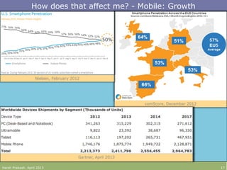
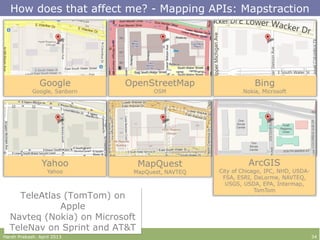
![How does that affect me? - Data: Services and Formats
Harsh Prakash. April 2013 28
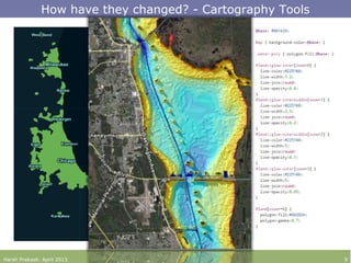
GML
<gml:pos>40 80</gml:pos>
GML
<gml:pos>40 80</gml:pos>
GeoRSS
<georss:point>40 80</georss:point>
GeoRSS
<georss:point>40 80</georss:point>
RSS
<geo:lat>40</geo:lat>
RSS
<geo:lat>40</geo:lat>
KML
<coordinates>40, 80</coordinates>
KML
<coordinates>40, 80</coordinates>
JSON, GeoJSON, TopoJSON
{“type”: “Point”, “coordinates”: [40, 80]}
JSON, GeoJSON, TopoJSON
{“type”: “Point”, “coordinates”: [40, 80]}
WKT
POINT (40 -80)
WKT
POINT (40 -80)
GPX
<wpt lat="40" lon="80"></wpt>
GPX
<wpt lat="40" lon="80"></wpt>
ATOM
<gml:pos>40 80</gml:pos>
ATOM
<gml:pos>40 80</gml:pos>
WCS
Web Coverage Service
WCS
Web Coverage Service
TMS
Tiled Map Service
TMS
Tiled Map Service
WFS
Web Feature Service
WFS
Web Feature Service
WMS
Web Mapping Service
WMS
Web Mapping Service](https://image.slidesharecdn.com/tech201-mappingmashups-130417120523-phpapp02/85/GIS-TECH-201-Mapping-Mashups-28-320.jpg)
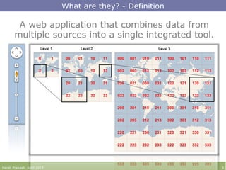
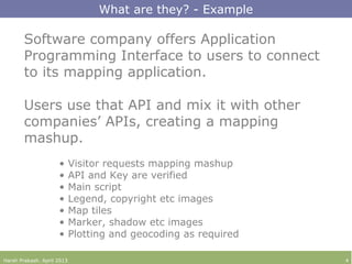
The document discusses the concept of mapping mashups, which are web applications that integrate data from multiple sources using APIs. It explores their evolution, current trends, and future possibilities in the context of technology, mobile growth, and social media integration. Additionally, it addresses issues related to data privacy, accessibility, and security and emphasizes the increasing significance of spatial data.