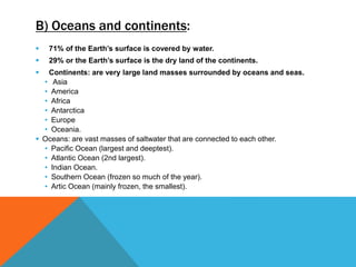
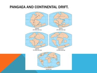
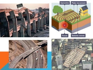
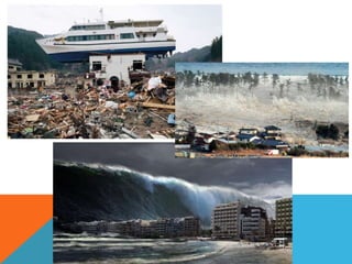
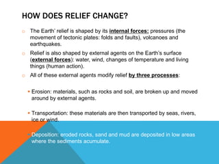
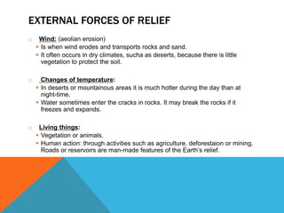
TỔNG ÔN TẬP THI VÀO LỚP 10 MÔN TIẾNG ANH NĂM HỌC 2023 - 2024 CÓ ĐÁP ÁN (NGỮ Â...
Unit2.theearth'srelief
1.
2. 1. THE EARTH’S CRUST.
A) The earth’s structure.
The Earth is a rocky, almost spherical planet divided into three concentric
layers:
① The core consists of the inner core and
the outer core (molten materials).
② The mantle is made up of materials
such as molten rock or magma.
③ The crust is a layer of solid rock
such as basalt or granite. The outer
part of the crust is the lithosphere.
The Earth’s temperature increases with depth.
The activity inside the Earth can be seen on the Earth’s crust, because this
produces different types of relief.
3. B) Oceans and continents:
71% of the Earth’s surface is covered by water.
29% or the Earth’s surface is the dry land of the continents.
Continents: are very large land masses surrounded by oceans and seas.
• Asia
• America
• Africa
• Antarctica
• Europe
• Oceania.
Oceans: are vast masses of saltwater that are connected to each other.
• Pacific Ocean (largest and deeptest).
• Atlantic Ocean (2nd largest).
• Indian Ocean.
• Southern Ocean (frozen so much of the year).
• Artic Ocean (mainly frozen, the smallest).
4.
5.
6.
7. 2. WHAT IS THE EARTH’S RELIEF?
Relief: Consisting of all the features, such as the mountains and
valleys,
which make the terrain so varied (watch the vocabulary
presentation!!!)
a) Continental relief:
Mountains
(mountain ranges)
Valleys
Plains
Plateaus
Basins
b) Coastal relief:
Cliffs
Beaches
Peninsula
Isthmus
Cape
Island
Gulf
Bay
c) Ocean floor ’ s
relief:
Continentel shelf
Continental slope
Abyssal plains
Mid-ocean ridges
Ocean trenches
8. 3. INTERNAL FORCES OF RELIEF.
THEORY OF CONTINENTAL DRIFT:
Many million years ago there was only a single super-continent, called
Pangaea, which broke up into fragments to make the continents we have
today.
Look at the coasts of the current continents, we can see that they seem
to match like an enormous jigsaw.
10. TECTONIC PLATES:
The Earth’s crust is not just one big piece of rock. It is divided into smaller pieces of
crust called tectonic plates.
The plates move because the mantle underneath them is moving, but they only
move very slowly.
The places where the plates meet are called plate boundaries or plate margins.
11. WHAT HAPPENS WHEN THE PLATES MOVE?
FAULTS AND FOLDS:
Below the surface of the Earth, gases and compressed materials put
pressure on the crust. They can deform it or make it crack. They are
called INTERNAL FORCES.
The Earth’s surface ondulates or fractures by the pressure from molten
materials in the mantle.
When Earth’s surface ondulates FOLDS are created.
When the surface is extremely ridig FAULTS are
created, and one block rise while the other sink.
12. Fold:
• When two plates move towards each other the Earth’s surface is forced
upwards or folded.
• This happens very slowly.
13. Faults:
• When the plates againts each other, pressure can build up. Sometimes
this causes the rock to split, making a fault in the rock.
• On one side of the fault, the ground rises, and on the other side it falls.
14. VOLCANOES:
• A volcano is an openning in the surface of the Earth through which very hot
material (magma) comes out.
• When magma comes out of a volcano, it is called lava.
• Volcanic cones are the result of lava accumulating outside the opening.
• Volcanoes are generally found on the edge os tectonic plates because this is
the weakest part of the Earth’s crust.
15.
16. EARTHQUAKES:
• Sometimes the increase in pressure at a plate boundary can cause a release
of energy that makes the ground shake. This is called a earthquake.
• The point in the ground where the earthquake starts is called the focus or
hypocentre.
• Shock waves or seismic waves are vibrations that spread out from the focus.
• The epicentre is the point on the Earth’s surface above the focus.
• We measure the strength of an earthquake using the Richter Scale.
17.
18. TSUNAMIS:
• If earthquakes and volcanic eruptions happen in or near the sea, they can
displace sea water, and this causes a tsunami.
• A tsunami is a series of enormous waves.
• It can cause a lot of damage to coastal areas.
• TEDeD lesson:https://ed.ted.com/lessons/how-tsunamis-work-alex-
gendler#watch
19.
20. Remember: the earth’s crust
It is thicker where it forms the continents and thinner where the oceans cover
it.
The crust is not smooth, there are features of land relief (mountains, valleys,
basins or depressions and plains) on land and under the sea.
The Earth’s relief is constantly changing because of internal and external
forces.
21. HOW DOES RELIEF CHANGE?
o The Earth’ relief is shaped by its internal forces: pressures (the
movement of tectonic plates: folds and faults), volcanoes and
earthquakes.
o Relief is also shaped by external agents on the Earth’s surface
(external forces): water, wind, changes of temperature and living
things (human action).
o All of these external agents modify relief by three processes:
Erosion: materials, such as rocks and soil, are broken up and moved
around by external agents.
Transportation: these materials are then transported by seas, rivers,
ice or wind.
Deposition: eroded rocks, sand and mud are deposited in low areas
where the sediments acumulate.
22. EXTERNAL FORCES OF RELIEF
o Water: plays a very important role in erosion, transport and deposition (rivers,
seas and oceans, rain water and ground water).
23. EXTERNAL FORCES OF RELIEF
o Wind: (aeolian erosion)
Is when wind erodes and transports rocks and sand.
It often occurs in dry climates, sucha as deserts, because there is little
vegetation to protect the soil.
o Changes of temperature:
In deserts or mountainous areas it is much hotter during the day than at
night-time.
Water sometimes enter the cracks in rocks. It may break the rocks if it
freezes and expands.
o Living things:
Vegetation or animals.
Human action: through activities such as agriculture, deforestaion or mining.
Roads or reservoirs are man-made features of the Earth’s relief.