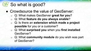
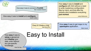
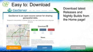
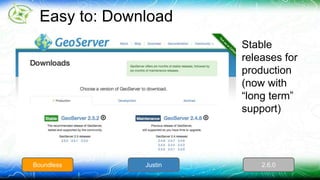
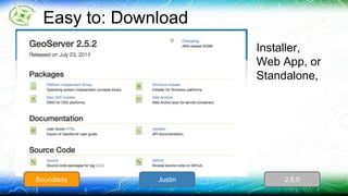
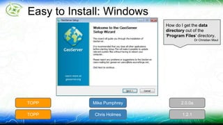
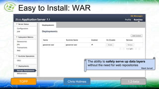
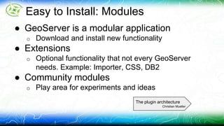
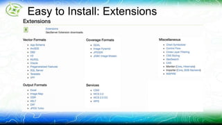
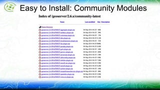
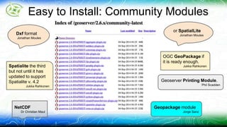
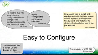
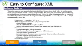
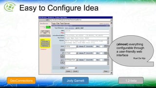
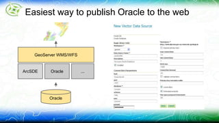
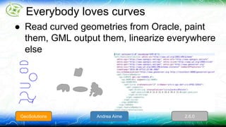
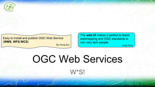
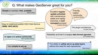
GeoServer Feature Frenzy 
This is going to be fast
Why this Talk? 
● State of GeoServer talks hit what is New! 
● This talk hits what is good! 
● 25 min talk 
o Thirty seconds a feature!
So what is good? 
● Crowdsource the value of GeoServer: 
o Q: What makes GeoServer great for you? 
o Q: What feature do you always enable? 
o Q: Is there an extension which made a project 
possible for you or a customer? 
o Q: What surprised you when you first installed 
GeoServer? 
o Q: What community module do you wish was part 
of GeoServer?
3 
Customer
2 
Implementor
1 
Release
Go!
How easy it was to install and configure. 
David Collins 
How easy it was to get maps in my 
openlayers application. 
Easy to Install 
Mark Ismail 
Easy to create a map 
Bui Hong Son 
How easy it was to install and 
configure with GUI without a need 
to write mysterious configuration 
files by hand, and that after the 
clickety-click installation everything 
just worked. 
Jukka Rahkonen 
How easy it was to connect to PostGIS. 
Ben Caradoc-Davies 
How easy it was to 
setup a geoserver 
and display your 
data, even without 
any gis-specific 
knowledge. 
Roel De Nijs
Easy to: Download 
Download latest 
Releases and 
Nightly Builds from 
the Home page! 
Boundless Justin 2.6.0
Easy to: Download 
Stable 
releases for 
production 
(now with 
“long term” 
support) 
Boundless Justin 2.6.0
Easy to: Download 
Installer, 
Web App, or 
Standalone, 
Boundless Justin 2.6.0
Easy to Install: Windows 
How do I get the data 
directory out of the 
'Program Files' directory. 
TOPP Mike Pumphrey 2.0.0a 
TOPP Chris Holmes 1.2.1 
Dr Christian Maul
Easy to Install: Windows Service 
Easy to install and 
publish OGC Web 
Service 
(WMS, WFS,WCS) 
Bui Hong Son 
TOPP Mike Pumphrey 1.7.1
Easy to Install: Mac 
TOPP Justin 1.7.1
Easy to Install: Binary (Windows) 
> unzip geoserver-2.6-RC1-bin.zip 
> cd geoserver-2.6-RC1 
> cd bin 
> start.bat 
TOPP Chris Holmes 1.2-beta
Easy to Install: Binary (Everyone) 
> unzip geoserver-2.6-RC1-bin.zip 
> cd geoserver-2.6-RC1 
> cd bin 
> ./start.sh 
TOPP Chris Holmes 1.2-beta
Easy to Install: WAR 
The ability to safely serve up data layers 
without the need for web repositories 
TOPP Chris Holmes 1.2-beta 
Mark Ismail
Easy to Install: Modules 
● GeoServer is a modular application 
o Download and install new functionality 
● Extensions 
o Optional functionality that not every GeoServer 
needs. Example: Importer, CSS, DB2 
● Community modules 
o Play area for experiments and ideas 
The plugin architecture 
Christian Mueller
Easy to Install: Extensions
Easy to Install: Community Modules
Easy to Install: Community Modules 
or SpatialLite 
Jonathan Moules Dxf format 
Jonathan Moules 
OGC GeoPackage if 
it is ready enough. 
Spatialite the third Jukka Rahkonen 
but not until it has 
updated to support 
Spatialite v. 4.2 
Jukka Rahkonen 
Geoserver Printing Module. 
Phil Scadden 
NetCDF 
Dr Christian Maul 
Geopackage module 
Jorge Sanz
How easy it was to install and 
configure with GUI without a need 
to write mysterious configuration 
files by hand, and that after the 
clickety-click installation everything 
just worked. 
Easy to Configure 
Jukka Rahkonen 
The short time it took 
to install GS and 
display my data 
Russell Hore 
The simplicity of WEB GUI 
Christian Mueller 
No need to dive into 
some obscure 
configuration files to 
change some 
configuration or add a 
new datastore, layer,… 
Roel De Nijs 
Highly 
configurable 
using a web 
interface 
Roel De Nijs
Easy to Configure: XML 
TOPP Rob 0.9
Easy to Configure Idea 
(almost) everything 
configurable through 
a user-friendly web 
interface 
Roel De Nijs 
GeoConnections Jody Garnett 1.2-beta
Easy to Configure STRUTS GUI 
GeoConnections Richard Gould 1.2-beta
Easy to Configure Wicket GUI 
Simple to maintain, 
free, scalable 
David Collins 
Very simple to 
set up 
Russell Hore 
TOPP Mike Pumphrey 2.0-beta
Mass configure layers from GUI 
Boundless Justin/Ian 2.4
Oracle 
(this is sort of strange) 
WFS-T and Oracle 
datastore 
Jukka Rahkonen 
The oracle database connector 
Mark Ismail 
Oracle database 
connection 
Jonathan Moules
Easiest way to publish Oracle to the web 
GeoServer WMS/WFS 
ArcSDE 
Oracle ... 
Oracle
Everybody loves curves 
● Read curved geometries from Oracle, paint 
them, GML output them, linearize everywhere 
else 
GeoSolutions Andrea Aime 2.6.0
rendering speed 
Phil Scadden 
Rendering Speed 
Your maps .. faster
Spatial Index 
● Key to rendering speed when zoomed in 
o Quickly sort through data using a bounding box 
o Remaining features filtered according to SLD
Geometry Simplification 
● Zoomed out so far that several 
points are located in the same pixel? 
o GeoServer will simplify as it reads from 
disk/database
Smart reprojection 
● Simplify before reproject 
● Linearize transformation math as needed
Pre Generalized DataStore 
● Switch between: 
o original data when zoomed in 
o simplified data when zoomed out 
● This is transparent to WMS and Rendering 
o No need to add SLD rules based on scale 
o Vast improvement when zoomed out! 
● For more information 
o Pregeneralized Plugin (GeoTools User Guide)
Switch tables based on distance 
<?xml version="1.0" encoding="UTF-8"?> 
<GeneralizationInfos version="1.0"> 
<GeneralizationInfo dataSourceName="dsStreams" featureName="GenStreams" 
baseFeatureName="streams" geomPropertyName="the_geom"> 
<Generalization dataSourceName="dsStreams_5" distance="5" 
featureName="streams_5" geomPropertyName="the_geom"/> 
<Generalization dataSourceName="dsStreams_10" distance="10" 
featureName="streams_10" geomPropertyName="the_geom"/> 
<Generalization dataSourceName="dsStreams_20" distance="20" 
featureName="streams_20" geomPropertyName="the_geom"/> 
<Generalization dataSourceName="dsStreams_50" distance="50" 
featureName="streams_50" geomPropertyName="the_geom"/> 
</GeneralizationInfo> 
</GeneralizationInfos>
Switch attributes based on distance 
<?xml version="1.0" encoding="UTF-8"?> 
<GeneralizationInfos version="1.0"> 
<GeneralizationInfo dataSourceName="dsStreams_5_10_20_50" featureName="GenStreams" 
baseFeatureName="streams_5_10_20_50" geomPropertyName="the_geom"> 
<Generalization dataSourceName="dsStreams_5_10_20_50" distance="5" 
featureName="streams_5_10_20_50" geomPropertyName="the_geom5"/> 
<Generalization dataSourceName="dsStreams_5_10_20_50" distance="10" 
featureName="streams_5_10_20_50" geomPropertyName="the_geom10"/> 
<Generalization dataSourceName="dsStreams_5_10_20_50" distance="20" 
featureName="streams_5_10_20_50" geomPropertyName="the_geom20"/> 
<Generalization dataSourceName="dsStreams_5_10_20_50" distance="50" 
featureName="streams_5_10_20_50" geomPropertyName="the_geom50"/> 
</GeneralizationInfo> 
</GeneralizationInfos>
Faster JPEG/PNG encoder 
TurboJPEG encoder 
PNGJ encoder
Shapefile
Shapefile 
GeoServer Features: 
● Fast efficient Rendering 
Whacky Things you don’t expect 
● Sorting implemented using separate file 
● Transactions (in memory) for WFS-T 
? Ian Schneider 0.9 
Refractions Jesse Eichar 1.2 
GeoSolutions Andrea Aime 2.2
Scalable 
Simple to maintain, free, scalable 
David Collins
Marlin renderer Marlin 
> 
OpenJDK 
> 
Oracle JDK 
Open Source For The 
Win! 
https://github.com/bourgesl/marlin-renderer 
Laurent 
Bourges 
Laurent 
Bourges 
2.5.0
Clustering solutions 
Laurent 
Bourges 
Laurent 
Bourges 
2.5.0 
Shared config DB
Free 
Simple to maintain, free, scalable 
David Collins 
Open Source 
Phil Scadden
Open Source 
Free as in Freedom: 
● GPL License
Cost Free 
Free as in Beer: 
● Download now to $0! 
● This weeks special 10% off $0!
Reliability and that it is largely data format agnostic 
Reliability 
Dr Christian Maul 
The ability to safely serve up data layers 
without the need for web repositories 
Mark Ismail 
It is a reliable product that is under 
continuous development and if there 
is a great need to get some new 
feature implemented there are several 
great companies who can take your 
money and make your happy soon. 
Jukka Rahkonen
Quality Assurance: JUnit 
● Build with Tests takes 15 mins 
● Build with Tests disabled takes 2 mins
Quality Assurance: Build Box 
Boundless: Linux+Java 6/7 GeoSolutions: Windows+Java7 CSIRO: Linux with space in path :)
Quality Assurance: Code Review
OGC Web Services 
W*S! 
Easy to install and publish OGC Web Service 
(WMS, WFS,WCS) 
Bui Hong Son 
The web UI makes it perfect to teach 
webmapping and OGC standards to 
non very tech people 
Jorge Sanz
OGC? Yes, from the ground up 
● WMS (1.1.1, 1.3.0) 
● WFS (1.0, 1.1, 2.0) 
● WCS (1.0, 1.1, 2.0) 
● WPS (1.0) 
● CSW (2.0.1) 
● SLD (1.0, 1.1) 
● GML (2.x, 3.1, 3.2) 
● KML 
● WMS and WCS Earth Observation profiles
CITE Tests
Friendly, 
helpful 
community. 
Jonathan Moules 
Its open and active community 
Ben Caradoc-Davies 
Open and Active 
Community 
Excellent regular 
update schedule 
with maintenance, 
stable and nightly 
branches. A well 
managed process! 
Jonathan Moules 
Open Development / Open Discussion
Open and Active Community 
● Community: Mailing List / Skype Meetings 
● GSIP Change Control 
● Release Schedule
Predicable Six-month Schedule
Open Development 
● geoserver-devel 
● developer manual 
o quickstart 
o release guide 
o clear contributor 
guidelines 
● Governance 
o PSC 
o OSGeo Project 
● GitHub 
○ Fork me on GitHub 
○ pull-requests 
● Proposals (GSIP) 
○ change control 
○ pre-flight check
It is a reliable product that is under 
continuous development and if there 
is a great need to get some new 
feature implemented there are several 
great companies who can take your 
money and make your happy soon. 
Jukka Rahkonen 
Commercial Support 
Send money now!
http://geoserver.org/support/
Excellent documentation 
Jorge Sanz 
Documentation 
The difference between W*S and W*F
Documentation 
● User Guide 
● Wiki 
● SLD Cookbook, and now CSS Cookbook 
● Developer Docs 
● Tutorials 
o JNDI, WMS Animator, CQL, Image Mosaic, ...
Easy to install and publish OGC Web Service 
(WMS, WFS,WCS) 
Bui Hong Son 
The ability to safely serve up data layers 
without the need for web repositories 
Web Map Server (WMS) 
The OGC Standard people Use! 
Mark Ismail 
Integrated WMS/WFS 
Phil Scadden 
WFS, WMS 
Bui Hong Son 
WFS, WMS, 
SqlServer 
database 
connection 
Roel De Nijs WMS and DB2 data store 
Christian Mueller 
CSS Styling 
(would be difficult to get 
staff trained on SLD - we 
are not IT experts) 
David Collins
Web Map Server (WMS) 
OGC Open Web Service GeoTools 
WFS 
● GetCapabilities 
WMS Operations 
● GetMap 
GetCapabilities 
● DescribeLayer 
● GetFeatureInfo 
● GetLegendGraphics 
getMap 
● GetStyles 
● PutStyles 
GIF
Styling languages 
● Standard or easy, your choice 
SLD 1.0/1.1 GeoCSS
SLD 1.0 
Axios Gabriel Roldan 1.2
SLD 1.1 
OpenGeo Justin Deoliveira 2.1
Geo-CSS 
David Winslow David Winslow 2.5
Reproject with confidence 
GeoServer handles dateline, projection limits, 
high accuracy projection grids, and so on 
Dateline wrap Cut on UTM 
Cut on polar stereographic
General interest maps 
OSM like, atlas like? Yes sir! 
IGN France 
Trimet :-)
GeoWebCache (GWC) 
It is full of Tiles 
GWC integration 
Phil Scadden 
Built in Tile caching 
Mark Ismail
Integrated tile caching 
● Fast and easy with the integrated 
GeoWebCache 
OpenGeo Arne Kepp 2.0
ECQL 
ECQL 
Phil Scadden
Extended Common Query Language 
A light weight “domain specific language”: 
● CQL - is a standard from OGC Catalog 
● E-CQL - extends this basic concept to do 
everything Filter can do
CQL Example 
POP_EST <= 5000000 AND 
POP_EST >100000
WFS 
Integrated WMS/WFS 
Phil Scadden 
Easy to install and publish OGC Web Service 
(WMS, WFS,WCS) 
Bui Hong Son 
WFS, WMS 
Bui Hong Son 
WFS, WMS, 
SqlServer 
database 
connection 
Roel De Nijs 
WFS-T and Oracle datastore 
Jukka Rahkonen 
Web UI and WFS working 
without any special config. 
Jorge Sanz
Web Feature Server (WFS) 
GeoTools WFS 
GetCapabilities 
DescribeFeatureType 
XSD 
GetFeatures 
GML 
OGC Open Web Service 
● GetCapabilities 
WFS Compliant 
● DescribeFeatureType 
● GetFeatures 
WFS-T Compliant 
● Transaction 
● LockFeatures 
● GetFeaturesWithLock
ArcSDE Data sources that it can use 
(particularly ArcSDE, PostGIS) 
Phil Scadden 
ArcSDE, WPS 
Phil Scadden
ArcSDE 
GeoServer WMS/WFS 
ArcSDE 
ArcSDE 
Oracle ...
PostGIS 
Data sources that it can use 
(particularly ArcSDE, PostGIS) 
(We expected more here) 
Phil Scadden 
How easy it was to connect to PostGIS. 
Ben Caradoc-Davies
ArcSDE 
GeoServer WMS/WFS 
ArcSDE 
PostGIS ... 
PostGIS
KML 
KML 
David Collins 
kmlscore system for KML 
(Allowed us to set up highly efficient public Google Earth system) 
David Collins
Just setup a map, GS will do the rest
Time travel enabled
Getting into the 3rd dimension
SQLServer 
WFS, WMS, 
SqlServer 
database 
connection 
Roel De Nijs 
SqlServer 
database 
connection 
Roel De Nijs
SqlServer 
GeoServer WMS/WFS 
PostGIS 
SQLServer ... 
SQLServer
WPS with SLD rendering transformations 
(and chained with SQL views, incredibly flexible combination) 
WPS 
WPS 
Jorge Sanz 
ArcSDE, WPS 
Phil Scadden 
Jorge Sanz
Integrated WPS 
● Analyze, 
publish, 
transform on 
the fly, access 
local data 
Andrea/Justin Andrea/Justin 2.0 
Refractions Cory Horner 1.7
Rendering transformations 
Apply processes (from WPS) to your SLD for 
on-the-fly data transformation 
GeoSolutions Andrea Aime 2.2
GeoTools or GeoScript Processes 
@process( 
title='Buffer', 
description='Buffers a geometry', 
inputs={'geom': (Geometry, 'The geometry to buffer'), 
'distance':(float,'The buffer distance')}, 
outputs={'result': (Geometry, 'The buffered geometry')} 
) 
def run(geom, distance): 
return geom.buffer(distance);
DB2 
WMS and DB2 data store 
Christian Mueller 
DB2 data store 
Christian Mueller
DB2 
GeoServer WMS/WFS 
Oracle 
DB2 ... 
DB2
App-Schema 
(Ben is a Huge Fan) 
app-schema of course :) 
Ben Caradoc-Davies 
WFS featureMember 
Ben Caradoc-Davies 
OGC HTTP URI format for srsName 
Ben Caradoc-Davies 
Canonical schema location 
Ben Caradoc-Davies
App Schema
WFS-T 
WFS-T and Oracle datastore 
(the original super power) 
Jukka Rahkonen
Editing your data since 2003 
WFS-T 
ArcSDE 
PostGIS 
Oracle 
Shapefile 
SQLServer 
... 
Refractions Jody Garnett 1.1
Inspire (helps to get around our problems with 
non-ISO-conforming metadata) 
Inspire 
Dr Christian Maul
INSPIRE 
<inspire_vs:ExtendedCapabilities> 
<inspire_common:MetadataUrl xsi:type="inspire_common:resourceLocatorType"> 
<inspire_common:URL/> 
<inspire_common:MediaType>application/vnd.iso.19139+xml</inspire_common:MediaType> 
</inspire_common:MetadataUrl> 
<inspire_common:SupportedLanguages xsi:type="inspire_common:supportedLanguagesType"> 
<inspire_common:DefaultLanguage> 
<inspire_common:Language>eng</inspire_common:Language> 
</inspire_common:DefaultLanguage> 
<inspire_common:SupportedLanguage> 
<inspire_common:Language>eng</inspire_common:Language> 
</inspire_common:SupportedLanguage> 
</inspire_common:SupportedLanguages> 
<inspire_common:ResponseLanguage> 
<inspire_common:Language>eng</inspire_common:Language> 
</inspire_common:ResponseLanguage></inspire_vs:ExtendedCapabilities>
WPS with SLD rendering transformations 
(and chained with SQL views, incredibly flexible combination) 
Jorge Sanz 
SQL Views 
In App Views
SqlViews 
GeoServer WMS/WFS 
... 
Any DB ... 
Run query as 
layer source 
DB2 
GBIF Andrea Aime 2.1.0
Parametric SQL Views 
GeoServer WMS/WFS 
... 
Any DB ... 
DBMS 
Inject params from request 
Run query as 
layer source 
GBIF Andrea Aime 2.1.0
Not of current extensions. 
NetCDF and cross-layer filtering 
loom large in the future. 
Multidimensional data 
weather or not you are ready 
Phil Scadden 
NetCDF 
Dr Christian Maul
Multidimensional data, in and out! 
● Time, elevation in WMS/WCS 
GeoSolutions Various people 2.2.0
Multidimensional data formats 
GRIB 
Daniele 
Romagnoli 
DLR 2.5
Meteorology ready! 
Temperature, currents, wind, pressure, time 
and elevation? We got you covered! 
Simone 
GeoSolutions 2.5 
Giannecchini
Security 
Stop or I will say Stop Again 
Web Service 
security standard 
authkey, Bui Hong Son 
should do this by myself 
Christian Mueller
Authentication and Authorization 
Fully pluggable!
Question and Answer 
Thanks!
What should be next! 
● SLD Editor, and more SLD Editor 
● GeoPackage* 
● GeoGit 
● SpatialLite 
● Importer* 
● Printing*
What will be Next? 
State of GeoServer, GeoTools and Friends 
● For the latest news and features 
● A hint of what developers have lined up
The plugin architecture 
Christian Mueller 
Q: What makes GeoServer great for you? 
Simple to maintain, free, scalable 
David Collins 
Reliability and that it is largely data format agnostic 
Its open and active community Dr Christian Maul 
Ben Caradoc-Davies 
The ability to safely serve up data layers 
without the need for web repositories 
Mark Ismail 
Easy to install and publish OGC Web Service 
(WMS, WFS,WCS) 
Bui Hong Son 
Friendly, 
helpful 
community. 
Jonathan Moules 
Very simple to set up 
Russell Hore 
Excellent regular 
update schedule 
with maintenance, 
stable and nightly 
branches. A well 
managed process! 
Jonathan Moules
Q: What makes GeoServer great for you? 
It is a reliable product that is under 
continuous development and if there 
is a great need to get some new 
feature implemented there are several 
great companies who can take your 
money and make your happy soon. 
Jukka Rahkonen 
Easy to deploy 
Jorge Sanz 
Excellent documentation 
Jorge Sanz 
The web UI makes it perfect to teach 
webmapping and OGC standards to 
non very tech people 
Jorge Sanz 
Friendly, 
helpful and 
very active 
community 
Roel De Nijs 
Great release 
management 
process 
Roel De Nijs 
Very 
simple/easy 
to setup 
Roel De Nijs 
Highly 
configurable 
using a web 
interface 
Roel De Nijs
Q: What makes GeoServer great for you? 
Open Source 
Phil Scadden 
GWC integration 
Integrated WMS/WFS 
Phil Scadden 
Phil Scadden 
Data sources that it can use 
(particularly ArcSDE, PostGIS) 
Phil Scadden 
That it didn't take days to simply install it 
because you'd changed from make to 
cmake and hadn't updated your 
documentation :P 
GUI admin 
Phil Scadden 
180 degree line handling 
Phil Scadden 
Cascaded WMS 
Phil Scadden 
ECQL 
Phil Scadden 
@kevin_rudds_cat 
the best thing about geoserver for me; 
compliant to standards and the ability to 
let power users in to serve data 
@miblon 
The fact that I can set up stuff in the 
user interface. And that I can work on 
setup files if needed. 
@raglar
Q: What feature do you always enable? 
CSS Styling 
(would be difficult to get staff trained on SLD - we are not IT experts) 
David Collins 
KML 
David Collins 
OGR2OGR 
Dr Christian Maul 
WFS featureMember 
Ben Caradoc-Davies 
Canonical schema location 
Ben Caradoc-Davies 
OGC HTTP URI format for srsName 
Ben Caradoc-Davies 
Built in Tile caching 
Mark Ismail 
WFS, WMS 
Bui Hong Son 
WMS 
Jonathan Moules 
WMS and DB2 data store 
Christian Mueller 
WPS 
Jorge Sanz WFS, WMS, 
SqlServer 
database 
connection 
Roel De Nijs 
ArcSDE, WPS 
Phil Scadden 
No 
Russell Hore
Oracle database 
connection 
Jonathan Moules 
Q: Is there an extension which 
made a project possible for you or a customer? 
Inspire (helps to get around our problems with 
non-ISO-conforming metadata) 
Dr Christian Maul 
kmlscore system for KML 
(Allowed us to set up highly efficient public Google Earth system) 
David Collins 
The oracle database connector 
Mark Ismail 
SDE connector 
Bui Hong Son 
WFS-T and Oracle datastore 
Jukka Rahkonen 
DB2 data store 
Christian Mueller 
SqlServer 
database 
connection 
Roel De Nijs
Q: Is there an extension which 
made a project possible for you or a customer? 
Not of current extensions. 
NetCDF and cross-layer filtering 
loom large in the future. 
Phil Scadden 
app-schema of course :) 
Ben Caradoc-Davies 
WPS with SLD rendering transformations 
(and chained with SQL views, incredibly flexible combination) 
Jorge Sanz 
Not yet. GS does everything I 
need to do without extra 
extensions a.t.m 
Russell Hore
Q: What surprised you when you first installed GeoServer? 
(it has been 
too long) 
Jonathan Moules 
How easy it was to install and configure. 
David Collins 
How easy it was to get maps in my 
openlayers application. 
Mark Ismail 
Easy to create a map 
Bui Hong Son 
The short time it took 
to install GS and 
display my data 
Russell Hore 
Web UI and WFS working 
without any special config. 
Jorge Sanz 
The simplicity of WEB GUI 
Christian Mueller 
Is this a leading question? :) 
David Collins 
How do I get the data directory 
out of the 'Program Files' directory. 
(That was version 1.7.4 with Jetty installer.) 
Dr Christian Maul
Q: What surprised you when you first installed GeoServer? 
How easy it was to install and 
configure with GUI without a need 
to write mysterious configuration 
files by hand, and that after the 
clickety-click installation everything 
just worked. 
Jukka Rahkonen 
Just a few clicks and I could see a map and simple feature WFS. 
Ben Caradoc-Davies 
How easy it was to connect to PostGIS. 
Ben Caradoc-Davies 
Everything just worked. 
Ben Caradoc-Davies 
How easy it was to 
setup a geoserver 
and display your 
data, even without 
any gis-specific 
knowledge. 
Roel De Nijs 
No need to dive into 
some obscure 
configuration files to 
change some 
configuration or add a 
new datastore, layer,… 
Roel De Nijs 
(almost) everything 
configurable through 
a user-friendly web 
interface 
Roel De Nijs
Q: What surprised you when you first installed GeoServer? 
rendering speed 
Phil Scadden
Q: What community module 
do you wish was part of GeoServer? 
NetCDF 
Dr Christian Maul 
Web Service 
security standard 
Bui Hong Son 
Geopackage module, and waiting 
for the GeoGig stack :-) 
A really good gui based tool for creating SLD. 
Mark Ismail 
None at the moment 
Russell Hore 
Jorge Sanz 
Some SLD editor 
to make 
maintenance less 
cumbersome 
Roel De Nijs 
a sort of visual 
editor should be a 
great improvement 
Diego Guidi
Q: What community module 
do you wish was part of GeoServer? 
Geoserver Printing Module. 
Biggest issue with printing however is 
integrating google map layers used with 
geoserver layers. 
Phil Scadden 
or SpatialLite 
(I think Dxf is in 
2.6 anyway 
right?) 
Jonathan Moules 
Jonathan Moules 
Dxf format 
Jonathan Moules 
authkey, 
should do this by myself 
Christian Mueller 
OGC GeoPackage if 
it is ready enough. 
Jukka Rahkonen 
Importer is my 
second candidate 
Jukka Rahkonen 
Spatialite the third 
but not until it has 
updated to support 
Spatialite v. 4.2 
Jukka Rahkonen
Quotes This e-mail and any attachments 
are confidential. It may contain 
privileged information and is 
intended for the named 
recipient(s) only. It must not be 
distributed without consent. If 
you are not one of the intended 
recipients, please notify the 
sender immediately and do not 
disclose, distribute, or retain this 
email or any part of it and do not 
take any action based on it. 
Unless expressly stated, 
opinions in this email are those 
of the individual sender, and not 
of XXXXXXX. Legally binding 
obligations can only be created 
for, or be entered into on behalf 
of, XXXXXXX by duly authorised 
officers or representatives. 
XXXXXXX excludes any liability 
whatsoever for any offence 
caused, any direct or 
consequential loss arising from 
the use, or reliance on, this e-mail 
or its contents. We believe 
but do not warrant that this e-mail 
and any attachments are 
virus free. You must therefore 
take full responsibility for virus 
checking and no responsibility is 
accepted for loss or damage 
arising from viruses or changes 
made to this message after it 
was sent. XXXXXXX reserves 
the right to monitor and/or record 
all e-mail communications 
through its network in 
accordance with relevant 
legislation. 
I was tasked with setting up geonode, with 
no prior GIS experience. 
I was very impressed by how geoserver 
Just Works as part of the geonode stack. 
Jean Jordaan 
Notice: This email and any attachments are confidential. 
If received in error please destroy and immediately notify us. 
Do not copy or disclose the contents. 
The best GIS server out there, no contest! 
My favorite story is publishing 2' contours from 
our LiDAR DEMS with just a WPS based 
SLD. Fantastic. 
Roger Bedell

GeoServer Feature Frenzy

  • 1.
    GeoServer Feature Frenzy This is going to be fast
  • 2.
    Why this Talk? ● State of GeoServer talks hit what is New! ● This talk hits what is good! ● 25 min talk o Thirty seconds a feature!
  • 3.
    So what isgood? ● Crowdsource the value of GeoServer: o Q: What makes GeoServer great for you? o Q: What feature do you always enable? o Q: Is there an extension which made a project possible for you or a customer? o Q: What surprised you when you first installed GeoServer? o Q: What community module do you wish was part of GeoServer?
  • 4.
  • 5.
  • 6.
  • 7.
  • 8.
    How easy itwas to install and configure. David Collins How easy it was to get maps in my openlayers application. Easy to Install Mark Ismail Easy to create a map Bui Hong Son How easy it was to install and configure with GUI without a need to write mysterious configuration files by hand, and that after the clickety-click installation everything just worked. Jukka Rahkonen How easy it was to connect to PostGIS. Ben Caradoc-Davies How easy it was to setup a geoserver and display your data, even without any gis-specific knowledge. Roel De Nijs
  • 9.
    Easy to: Download Download latest Releases and Nightly Builds from the Home page! Boundless Justin 2.6.0
  • 10.
    Easy to: Download Stable releases for production (now with “long term” support) Boundless Justin 2.6.0
  • 11.
    Easy to: Download Installer, Web App, or Standalone, Boundless Justin 2.6.0
  • 12.
    Easy to Install:Windows How do I get the data directory out of the 'Program Files' directory. TOPP Mike Pumphrey 2.0.0a TOPP Chris Holmes 1.2.1 Dr Christian Maul
  • 13.
    Easy to Install:Windows Service Easy to install and publish OGC Web Service (WMS, WFS,WCS) Bui Hong Son TOPP Mike Pumphrey 1.7.1
  • 14.
    Easy to Install:Mac TOPP Justin 1.7.1
  • 15.
    Easy to Install:Binary (Windows) > unzip geoserver-2.6-RC1-bin.zip > cd geoserver-2.6-RC1 > cd bin > start.bat TOPP Chris Holmes 1.2-beta
  • 16.
    Easy to Install:Binary (Everyone) > unzip geoserver-2.6-RC1-bin.zip > cd geoserver-2.6-RC1 > cd bin > ./start.sh TOPP Chris Holmes 1.2-beta
  • 17.
    Easy to Install:WAR The ability to safely serve up data layers without the need for web repositories TOPP Chris Holmes 1.2-beta Mark Ismail
  • 18.
    Easy to Install:Modules ● GeoServer is a modular application o Download and install new functionality ● Extensions o Optional functionality that not every GeoServer needs. Example: Importer, CSS, DB2 ● Community modules o Play area for experiments and ideas The plugin architecture Christian Mueller
  • 19.
    Easy to Install:Extensions
  • 20.
    Easy to Install:Community Modules
  • 21.
    Easy to Install:Community Modules or SpatialLite Jonathan Moules Dxf format Jonathan Moules OGC GeoPackage if it is ready enough. Spatialite the third Jukka Rahkonen but not until it has updated to support Spatialite v. 4.2 Jukka Rahkonen Geoserver Printing Module. Phil Scadden NetCDF Dr Christian Maul Geopackage module Jorge Sanz
  • 22.
    How easy itwas to install and configure with GUI without a need to write mysterious configuration files by hand, and that after the clickety-click installation everything just worked. Easy to Configure Jukka Rahkonen The short time it took to install GS and display my data Russell Hore The simplicity of WEB GUI Christian Mueller No need to dive into some obscure configuration files to change some configuration or add a new datastore, layer,… Roel De Nijs Highly configurable using a web interface Roel De Nijs
  • 23.
    Easy to Configure:XML TOPP Rob 0.9
  • 24.
    Easy to ConfigureIdea (almost) everything configurable through a user-friendly web interface Roel De Nijs GeoConnections Jody Garnett 1.2-beta
  • 25.
    Easy to ConfigureSTRUTS GUI GeoConnections Richard Gould 1.2-beta
  • 26.
    Easy to ConfigureWicket GUI Simple to maintain, free, scalable David Collins Very simple to set up Russell Hore TOPP Mike Pumphrey 2.0-beta
  • 27.
    Mass configure layersfrom GUI Boundless Justin/Ian 2.4
  • 28.
    Oracle (this issort of strange) WFS-T and Oracle datastore Jukka Rahkonen The oracle database connector Mark Ismail Oracle database connection Jonathan Moules
  • 29.
    Easiest way topublish Oracle to the web GeoServer WMS/WFS ArcSDE Oracle ... Oracle
  • 30.
    Everybody loves curves ● Read curved geometries from Oracle, paint them, GML output them, linearize everywhere else GeoSolutions Andrea Aime 2.6.0
  • 31.
    rendering speed PhilScadden Rendering Speed Your maps .. faster
  • 32.
    Spatial Index ●Key to rendering speed when zoomed in o Quickly sort through data using a bounding box o Remaining features filtered according to SLD
  • 33.
    Geometry Simplification ●Zoomed out so far that several points are located in the same pixel? o GeoServer will simplify as it reads from disk/database
  • 34.
    Smart reprojection ●Simplify before reproject ● Linearize transformation math as needed
  • 35.
    Pre Generalized DataStore ● Switch between: o original data when zoomed in o simplified data when zoomed out ● This is transparent to WMS and Rendering o No need to add SLD rules based on scale o Vast improvement when zoomed out! ● For more information o Pregeneralized Plugin (GeoTools User Guide)
  • 36.
    Switch tables basedon distance <?xml version="1.0" encoding="UTF-8"?> <GeneralizationInfos version="1.0"> <GeneralizationInfo dataSourceName="dsStreams" featureName="GenStreams" baseFeatureName="streams" geomPropertyName="the_geom"> <Generalization dataSourceName="dsStreams_5" distance="5" featureName="streams_5" geomPropertyName="the_geom"/> <Generalization dataSourceName="dsStreams_10" distance="10" featureName="streams_10" geomPropertyName="the_geom"/> <Generalization dataSourceName="dsStreams_20" distance="20" featureName="streams_20" geomPropertyName="the_geom"/> <Generalization dataSourceName="dsStreams_50" distance="50" featureName="streams_50" geomPropertyName="the_geom"/> </GeneralizationInfo> </GeneralizationInfos>
  • 37.
    Switch attributes basedon distance <?xml version="1.0" encoding="UTF-8"?> <GeneralizationInfos version="1.0"> <GeneralizationInfo dataSourceName="dsStreams_5_10_20_50" featureName="GenStreams" baseFeatureName="streams_5_10_20_50" geomPropertyName="the_geom"> <Generalization dataSourceName="dsStreams_5_10_20_50" distance="5" featureName="streams_5_10_20_50" geomPropertyName="the_geom5"/> <Generalization dataSourceName="dsStreams_5_10_20_50" distance="10" featureName="streams_5_10_20_50" geomPropertyName="the_geom10"/> <Generalization dataSourceName="dsStreams_5_10_20_50" distance="20" featureName="streams_5_10_20_50" geomPropertyName="the_geom20"/> <Generalization dataSourceName="dsStreams_5_10_20_50" distance="50" featureName="streams_5_10_20_50" geomPropertyName="the_geom50"/> </GeneralizationInfo> </GeneralizationInfos>
  • 38.
    Faster JPEG/PNG encoder TurboJPEG encoder PNGJ encoder
  • 39.
  • 40.
    Shapefile GeoServer Features: ● Fast efficient Rendering Whacky Things you don’t expect ● Sorting implemented using separate file ● Transactions (in memory) for WFS-T ? Ian Schneider 0.9 Refractions Jesse Eichar 1.2 GeoSolutions Andrea Aime 2.2
  • 41.
    Scalable Simple tomaintain, free, scalable David Collins
  • 42.
    Marlin renderer Marlin > OpenJDK > Oracle JDK Open Source For The Win! https://github.com/bourgesl/marlin-renderer Laurent Bourges Laurent Bourges 2.5.0
  • 43.
    Clustering solutions Laurent Bourges Laurent Bourges 2.5.0 Shared config DB
  • 44.
    Free Simple tomaintain, free, scalable David Collins Open Source Phil Scadden
  • 45.
    Open Source Freeas in Freedom: ● GPL License
  • 46.
    Cost Free Freeas in Beer: ● Download now to $0! ● This weeks special 10% off $0!
  • 47.
    Reliability and thatit is largely data format agnostic Reliability Dr Christian Maul The ability to safely serve up data layers without the need for web repositories Mark Ismail It is a reliable product that is under continuous development and if there is a great need to get some new feature implemented there are several great companies who can take your money and make your happy soon. Jukka Rahkonen
  • 48.
    Quality Assurance: JUnit ● Build with Tests takes 15 mins ● Build with Tests disabled takes 2 mins
  • 49.
    Quality Assurance: BuildBox Boundless: Linux+Java 6/7 GeoSolutions: Windows+Java7 CSIRO: Linux with space in path :)
  • 50.
  • 51.
    OGC Web Services W*S! Easy to install and publish OGC Web Service (WMS, WFS,WCS) Bui Hong Son The web UI makes it perfect to teach webmapping and OGC standards to non very tech people Jorge Sanz
  • 52.
    OGC? Yes, fromthe ground up ● WMS (1.1.1, 1.3.0) ● WFS (1.0, 1.1, 2.0) ● WCS (1.0, 1.1, 2.0) ● WPS (1.0) ● CSW (2.0.1) ● SLD (1.0, 1.1) ● GML (2.x, 3.1, 3.2) ● KML ● WMS and WCS Earth Observation profiles
  • 53.
  • 54.
    Friendly, helpful community. Jonathan Moules Its open and active community Ben Caradoc-Davies Open and Active Community Excellent regular update schedule with maintenance, stable and nightly branches. A well managed process! Jonathan Moules Open Development / Open Discussion
  • 55.
    Open and ActiveCommunity ● Community: Mailing List / Skype Meetings ● GSIP Change Control ● Release Schedule
  • 56.
  • 57.
    Open Development ●geoserver-devel ● developer manual o quickstart o release guide o clear contributor guidelines ● Governance o PSC o OSGeo Project ● GitHub ○ Fork me on GitHub ○ pull-requests ● Proposals (GSIP) ○ change control ○ pre-flight check
  • 58.
    It is areliable product that is under continuous development and if there is a great need to get some new feature implemented there are several great companies who can take your money and make your happy soon. Jukka Rahkonen Commercial Support Send money now!
  • 59.
  • 60.
    Excellent documentation JorgeSanz Documentation The difference between W*S and W*F
  • 61.
    Documentation ● UserGuide ● Wiki ● SLD Cookbook, and now CSS Cookbook ● Developer Docs ● Tutorials o JNDI, WMS Animator, CQL, Image Mosaic, ...
  • 62.
    Easy to installand publish OGC Web Service (WMS, WFS,WCS) Bui Hong Son The ability to safely serve up data layers without the need for web repositories Web Map Server (WMS) The OGC Standard people Use! Mark Ismail Integrated WMS/WFS Phil Scadden WFS, WMS Bui Hong Son WFS, WMS, SqlServer database connection Roel De Nijs WMS and DB2 data store Christian Mueller CSS Styling (would be difficult to get staff trained on SLD - we are not IT experts) David Collins
  • 63.
    Web Map Server(WMS) OGC Open Web Service GeoTools WFS ● GetCapabilities WMS Operations ● GetMap GetCapabilities ● DescribeLayer ● GetFeatureInfo ● GetLegendGraphics getMap ● GetStyles ● PutStyles GIF
  • 64.
    Styling languages ●Standard or easy, your choice SLD 1.0/1.1 GeoCSS
  • 65.
    SLD 1.0 AxiosGabriel Roldan 1.2
  • 66.
    SLD 1.1 OpenGeoJustin Deoliveira 2.1
  • 67.
    Geo-CSS David WinslowDavid Winslow 2.5
  • 68.
    Reproject with confidence GeoServer handles dateline, projection limits, high accuracy projection grids, and so on Dateline wrap Cut on UTM Cut on polar stereographic
  • 69.
    General interest maps OSM like, atlas like? Yes sir! IGN France Trimet :-)
  • 70.
    GeoWebCache (GWC) Itis full of Tiles GWC integration Phil Scadden Built in Tile caching Mark Ismail
  • 71.
    Integrated tile caching ● Fast and easy with the integrated GeoWebCache OpenGeo Arne Kepp 2.0
  • 72.
  • 73.
    Extended Common QueryLanguage A light weight “domain specific language”: ● CQL - is a standard from OGC Catalog ● E-CQL - extends this basic concept to do everything Filter can do
  • 74.
    CQL Example POP_EST<= 5000000 AND POP_EST >100000
  • 75.
    WFS Integrated WMS/WFS Phil Scadden Easy to install and publish OGC Web Service (WMS, WFS,WCS) Bui Hong Son WFS, WMS Bui Hong Son WFS, WMS, SqlServer database connection Roel De Nijs WFS-T and Oracle datastore Jukka Rahkonen Web UI and WFS working without any special config. Jorge Sanz
  • 76.
    Web Feature Server(WFS) GeoTools WFS GetCapabilities DescribeFeatureType XSD GetFeatures GML OGC Open Web Service ● GetCapabilities WFS Compliant ● DescribeFeatureType ● GetFeatures WFS-T Compliant ● Transaction ● LockFeatures ● GetFeaturesWithLock
  • 77.
    ArcSDE Data sourcesthat it can use (particularly ArcSDE, PostGIS) Phil Scadden ArcSDE, WPS Phil Scadden
  • 78.
    ArcSDE GeoServer WMS/WFS ArcSDE ArcSDE Oracle ...
  • 79.
    PostGIS Data sourcesthat it can use (particularly ArcSDE, PostGIS) (We expected more here) Phil Scadden How easy it was to connect to PostGIS. Ben Caradoc-Davies
  • 80.
    ArcSDE GeoServer WMS/WFS ArcSDE PostGIS ... PostGIS
  • 81.
    KML KML DavidCollins kmlscore system for KML (Allowed us to set up highly efficient public Google Earth system) David Collins
  • 82.
    Just setup amap, GS will do the rest
  • 83.
  • 84.
    Getting into the3rd dimension
  • 85.
    SQLServer WFS, WMS, SqlServer database connection Roel De Nijs SqlServer database connection Roel De Nijs
  • 86.
    SqlServer GeoServer WMS/WFS PostGIS SQLServer ... SQLServer
  • 87.
    WPS with SLDrendering transformations (and chained with SQL views, incredibly flexible combination) WPS WPS Jorge Sanz ArcSDE, WPS Phil Scadden Jorge Sanz
  • 88.
    Integrated WPS ●Analyze, publish, transform on the fly, access local data Andrea/Justin Andrea/Justin 2.0 Refractions Cory Horner 1.7
  • 89.
    Rendering transformations Applyprocesses (from WPS) to your SLD for on-the-fly data transformation GeoSolutions Andrea Aime 2.2
  • 90.
    GeoTools or GeoScriptProcesses @process( title='Buffer', description='Buffers a geometry', inputs={'geom': (Geometry, 'The geometry to buffer'), 'distance':(float,'The buffer distance')}, outputs={'result': (Geometry, 'The buffered geometry')} ) def run(geom, distance): return geom.buffer(distance);
  • 91.
    DB2 WMS andDB2 data store Christian Mueller DB2 data store Christian Mueller
  • 92.
    DB2 GeoServer WMS/WFS Oracle DB2 ... DB2
  • 93.
    App-Schema (Ben isa Huge Fan) app-schema of course :) Ben Caradoc-Davies WFS featureMember Ben Caradoc-Davies OGC HTTP URI format for srsName Ben Caradoc-Davies Canonical schema location Ben Caradoc-Davies
  • 94.
  • 95.
    WFS-T WFS-T andOracle datastore (the original super power) Jukka Rahkonen
  • 96.
    Editing your datasince 2003 WFS-T ArcSDE PostGIS Oracle Shapefile SQLServer ... Refractions Jody Garnett 1.1
  • 97.
    Inspire (helps toget around our problems with non-ISO-conforming metadata) Inspire Dr Christian Maul
  • 98.
    INSPIRE <inspire_vs:ExtendedCapabilities> <inspire_common:MetadataUrlxsi:type="inspire_common:resourceLocatorType"> <inspire_common:URL/> <inspire_common:MediaType>application/vnd.iso.19139+xml</inspire_common:MediaType> </inspire_common:MetadataUrl> <inspire_common:SupportedLanguages xsi:type="inspire_common:supportedLanguagesType"> <inspire_common:DefaultLanguage> <inspire_common:Language>eng</inspire_common:Language> </inspire_common:DefaultLanguage> <inspire_common:SupportedLanguage> <inspire_common:Language>eng</inspire_common:Language> </inspire_common:SupportedLanguage> </inspire_common:SupportedLanguages> <inspire_common:ResponseLanguage> <inspire_common:Language>eng</inspire_common:Language> </inspire_common:ResponseLanguage></inspire_vs:ExtendedCapabilities>
  • 99.
    WPS with SLDrendering transformations (and chained with SQL views, incredibly flexible combination) Jorge Sanz SQL Views In App Views
  • 100.
    SqlViews GeoServer WMS/WFS ... Any DB ... Run query as layer source DB2 GBIF Andrea Aime 2.1.0
  • 101.
    Parametric SQL Views GeoServer WMS/WFS ... Any DB ... DBMS Inject params from request Run query as layer source GBIF Andrea Aime 2.1.0
  • 102.
    Not of currentextensions. NetCDF and cross-layer filtering loom large in the future. Multidimensional data weather or not you are ready Phil Scadden NetCDF Dr Christian Maul
  • 103.
    Multidimensional data, inand out! ● Time, elevation in WMS/WCS GeoSolutions Various people 2.2.0
  • 104.
    Multidimensional data formats GRIB Daniele Romagnoli DLR 2.5
  • 105.
    Meteorology ready! Temperature,currents, wind, pressure, time and elevation? We got you covered! Simone GeoSolutions 2.5 Giannecchini
  • 106.
    Security Stop orI will say Stop Again Web Service security standard authkey, Bui Hong Son should do this by myself Christian Mueller
  • 107.
  • 108.
  • 109.
    What should benext! ● SLD Editor, and more SLD Editor ● GeoPackage* ● GeoGit ● SpatialLite ● Importer* ● Printing*
  • 110.
    What will beNext? State of GeoServer, GeoTools and Friends ● For the latest news and features ● A hint of what developers have lined up
  • 111.
    The plugin architecture Christian Mueller Q: What makes GeoServer great for you? Simple to maintain, free, scalable David Collins Reliability and that it is largely data format agnostic Its open and active community Dr Christian Maul Ben Caradoc-Davies The ability to safely serve up data layers without the need for web repositories Mark Ismail Easy to install and publish OGC Web Service (WMS, WFS,WCS) Bui Hong Son Friendly, helpful community. Jonathan Moules Very simple to set up Russell Hore Excellent regular update schedule with maintenance, stable and nightly branches. A well managed process! Jonathan Moules
  • 112.
    Q: What makesGeoServer great for you? It is a reliable product that is under continuous development and if there is a great need to get some new feature implemented there are several great companies who can take your money and make your happy soon. Jukka Rahkonen Easy to deploy Jorge Sanz Excellent documentation Jorge Sanz The web UI makes it perfect to teach webmapping and OGC standards to non very tech people Jorge Sanz Friendly, helpful and very active community Roel De Nijs Great release management process Roel De Nijs Very simple/easy to setup Roel De Nijs Highly configurable using a web interface Roel De Nijs
  • 113.
    Q: What makesGeoServer great for you? Open Source Phil Scadden GWC integration Integrated WMS/WFS Phil Scadden Phil Scadden Data sources that it can use (particularly ArcSDE, PostGIS) Phil Scadden That it didn't take days to simply install it because you'd changed from make to cmake and hadn't updated your documentation :P GUI admin Phil Scadden 180 degree line handling Phil Scadden Cascaded WMS Phil Scadden ECQL Phil Scadden @kevin_rudds_cat the best thing about geoserver for me; compliant to standards and the ability to let power users in to serve data @miblon The fact that I can set up stuff in the user interface. And that I can work on setup files if needed. @raglar
  • 114.
    Q: What featuredo you always enable? CSS Styling (would be difficult to get staff trained on SLD - we are not IT experts) David Collins KML David Collins OGR2OGR Dr Christian Maul WFS featureMember Ben Caradoc-Davies Canonical schema location Ben Caradoc-Davies OGC HTTP URI format for srsName Ben Caradoc-Davies Built in Tile caching Mark Ismail WFS, WMS Bui Hong Son WMS Jonathan Moules WMS and DB2 data store Christian Mueller WPS Jorge Sanz WFS, WMS, SqlServer database connection Roel De Nijs ArcSDE, WPS Phil Scadden No Russell Hore
  • 115.
    Oracle database connection Jonathan Moules Q: Is there an extension which made a project possible for you or a customer? Inspire (helps to get around our problems with non-ISO-conforming metadata) Dr Christian Maul kmlscore system for KML (Allowed us to set up highly efficient public Google Earth system) David Collins The oracle database connector Mark Ismail SDE connector Bui Hong Son WFS-T and Oracle datastore Jukka Rahkonen DB2 data store Christian Mueller SqlServer database connection Roel De Nijs
  • 116.
    Q: Is therean extension which made a project possible for you or a customer? Not of current extensions. NetCDF and cross-layer filtering loom large in the future. Phil Scadden app-schema of course :) Ben Caradoc-Davies WPS with SLD rendering transformations (and chained with SQL views, incredibly flexible combination) Jorge Sanz Not yet. GS does everything I need to do without extra extensions a.t.m Russell Hore
  • 117.
    Q: What surprisedyou when you first installed GeoServer? (it has been too long) Jonathan Moules How easy it was to install and configure. David Collins How easy it was to get maps in my openlayers application. Mark Ismail Easy to create a map Bui Hong Son The short time it took to install GS and display my data Russell Hore Web UI and WFS working without any special config. Jorge Sanz The simplicity of WEB GUI Christian Mueller Is this a leading question? :) David Collins How do I get the data directory out of the 'Program Files' directory. (That was version 1.7.4 with Jetty installer.) Dr Christian Maul
  • 118.
    Q: What surprisedyou when you first installed GeoServer? How easy it was to install and configure with GUI without a need to write mysterious configuration files by hand, and that after the clickety-click installation everything just worked. Jukka Rahkonen Just a few clicks and I could see a map and simple feature WFS. Ben Caradoc-Davies How easy it was to connect to PostGIS. Ben Caradoc-Davies Everything just worked. Ben Caradoc-Davies How easy it was to setup a geoserver and display your data, even without any gis-specific knowledge. Roel De Nijs No need to dive into some obscure configuration files to change some configuration or add a new datastore, layer,… Roel De Nijs (almost) everything configurable through a user-friendly web interface Roel De Nijs
  • 119.
    Q: What surprisedyou when you first installed GeoServer? rendering speed Phil Scadden
  • 120.
    Q: What communitymodule do you wish was part of GeoServer? NetCDF Dr Christian Maul Web Service security standard Bui Hong Son Geopackage module, and waiting for the GeoGig stack :-) A really good gui based tool for creating SLD. Mark Ismail None at the moment Russell Hore Jorge Sanz Some SLD editor to make maintenance less cumbersome Roel De Nijs a sort of visual editor should be a great improvement Diego Guidi
  • 121.
    Q: What communitymodule do you wish was part of GeoServer? Geoserver Printing Module. Biggest issue with printing however is integrating google map layers used with geoserver layers. Phil Scadden or SpatialLite (I think Dxf is in 2.6 anyway right?) Jonathan Moules Jonathan Moules Dxf format Jonathan Moules authkey, should do this by myself Christian Mueller OGC GeoPackage if it is ready enough. Jukka Rahkonen Importer is my second candidate Jukka Rahkonen Spatialite the third but not until it has updated to support Spatialite v. 4.2 Jukka Rahkonen
  • 122.
    Quotes This e-mailand any attachments are confidential. It may contain privileged information and is intended for the named recipient(s) only. It must not be distributed without consent. If you are not one of the intended recipients, please notify the sender immediately and do not disclose, distribute, or retain this email or any part of it and do not take any action based on it. Unless expressly stated, opinions in this email are those of the individual sender, and not of XXXXXXX. Legally binding obligations can only be created for, or be entered into on behalf of, XXXXXXX by duly authorised officers or representatives. XXXXXXX excludes any liability whatsoever for any offence caused, any direct or consequential loss arising from the use, or reliance on, this e-mail or its contents. We believe but do not warrant that this e-mail and any attachments are virus free. You must therefore take full responsibility for virus checking and no responsibility is accepted for loss or damage arising from viruses or changes made to this message after it was sent. XXXXXXX reserves the right to monitor and/or record all e-mail communications through its network in accordance with relevant legislation. I was tasked with setting up geonode, with no prior GIS experience. I was very impressed by how geoserver Just Works as part of the geonode stack. Jean Jordaan Notice: This email and any attachments are confidential. If received in error please destroy and immediately notify us. Do not copy or disclose the contents. The best GIS server out there, no contest! My favorite story is publishing 2' contours from our LiDAR DEMS with just a WPS based SLD. Fantastic. Roger Bedell

Editor's Notes

  • #2 Abstract What can you do with this GeoServer thing? This talk covers some of the basic (and not so basic) ways to use GeoServer to publish your geospatial data and make it look great! GeoServer made its first release in 2001 and has grown into an amazing, capable and diverse program. This also means the “feature list” is spread over years of release announcements, presentations, mailing list archives! This presentations provides a whirlwind tour of GeoServer and everything it can do today! This talk is a visual guide to the features of GeoServer. Are you just getting started with GeoServer, or considering it for the first time? Attend this talk and prioritize what you want to look into first. Are you an expert user who has been running GeoServer since Java 1.4? Attend this talk and see what tricks an optimisations you have been missing out on! Outline - 20 mins, 30 seconds a feature, aim for around 40 features - Tag team the presentation, no hesitation, time to rock and roll - Take content from previous “State of Talks” - Short listed some content via user-group and twitter, the rest we can fill in with what is cool and or saves money - If we see logical groups for content then we can do so - end by thanking the team, the customers and the organisations that made GeoServer what it is today
  • #3 JODY
  • #4 JODY
  • #5 AA
  • #6 AA
  • #7 AA
  • #8 ALL
  • #9 JODY Slide for Windows Installer Slide for Mac App Slide for Linux start.sh Slide for WAR (Tomcat Management UI) Slide for Embedded Jetty
  • #10 JG
  • #12 JG
  • #13 JG See http://jira.codehaus.org/browse/GEOS-82
  • #14 JG http://jira.codehaus.org/browse/GEOS-2517
  • #15 JG See http://jira.codehaus.org/browse/GEOS-2285
  • #16 JG http://jira.codehaus.org/browse/GEOS-60
  • #17 JG
  • #18 JG https://jira.codehaus.org/browse/GEOS-66
  • #23 AA Joke: Show GeoServer 0.x XML Joke: Show GeoServer 1.0 STRUTS 5 pictures of adding a store, adding a layer, previewing a layer
  • #24 XML Considered “human readable” (For GeoServer 1.0)
  • #25 https://jira.codehaus.org/browse/GEOS-83
  • #29 JG
  • #30 Are we sure? Oracle has its own map server. Maybe easiest open source way ;-)
  • #32 AA
  • #37  Swap between PostGIS tables (easy to manage but duplicates attributes)
  • #38 Swap between geometry columns (no attribute duplication)
  • #40 JG
  • #42 AA
  • #45 JG
  • #48 AA Build Boxes and QA - JUnit Green bar of happiness - Jenkins weather report
  • #49 Green Bar of Happiness
  • #52 JG
  • #55 AA
  • #59 JG Web page for commercial support
  • #61 AA
  • #63 JG
  • #71 AA
  • #73 JG
  • #76 AA
  • #78 AA
  • #80 JG
  • #82 AA
  • #86 JG
  • #88 AA
  • #91 See: http://www.slideshare.net/JaredErickson/scripting-geoserver
  • #92 JG
  • #94 AA
  • #96 JG
  • #98 AA
  • #100 JG
  • #101 Are we sure? Oracle has its own map server. Maybe easiest open source way ;-)
  • #102 Are we sure? Oracle has its own map server. Maybe easiest open source way ;-)
  • #103 AA
  • #104 Are we sure? Oracle has its own map server. Maybe easiest open source way ;-)
  • #105 Are we sure? Oracle has its own map server. Maybe easiest open source way ;-)
  • #107 JG
  • #109 BOTH
  • #123 Email footer is off topic but funny