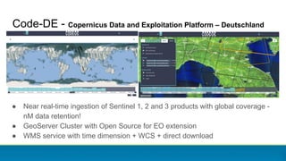
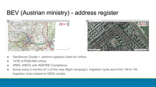
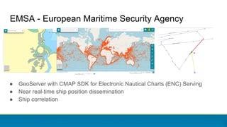
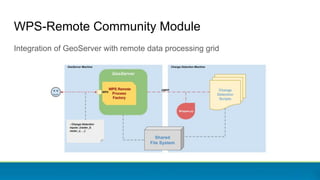
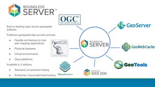
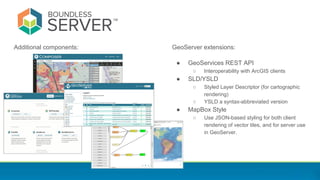
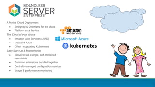
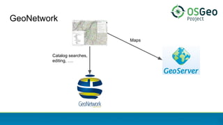
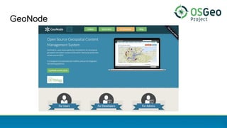
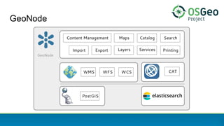
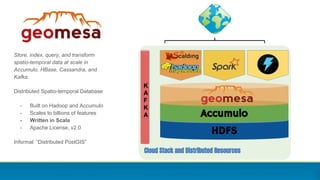
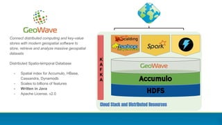
This document discusses the GeoServer ecosystem and integrations. GeoServer is an open source geospatial data server that can publish data using open standards. It is used by many organizations to serve maps and geospatial data on the web. The document highlights several integrations and uses of GeoServer including by government agencies to serve satellite imagery, cadastral data, and more. It also discusses commercial support from Boundless and how GeoServer can be deployed in cloud environments and integrated with other open source geospatial tools like GeoNetwork, GeoNode, and World Wind Server.
2. Powered by GeoServer
GeoServer is a real open source, and OSGeo, success story in its own right.
● Open Source GPL License
● Established project first released in 2001!
● Diverse global development community
● Open Source Geospatial Foundation Project since 2011
● … but that is not what this talk is about!
GeoServer, as a component, powers a wide ecosystem of great solutions!
3. GeoServer at a Glance
Java Web Application to share and
edit geospatial data.
Publish data from any major spatial
data source using open standards.
Core Protocols
WMS – maps
WFS – vector
WFS-T – editing
WCS – coverage
WMTS – tiles
TMS – tiles
WMS-C – tiles
Extension/community protocols
WPS – process
CSW – search
OpenSearch for Earth Observation – search
5. Introducing Andrea Aime (GeoSolutions)
Andrea Aime
Technical Lead
andrea.aime@geo-solutions.it
@geowolf
GeoServer and GeoTools core developer and
project steering committee member
GeoSolutions
Innovative, robust and cost-effective solutions
leveraging best-of-breed Open Source products.
GeoServer, GeoNode, MapStore, GeoNetwork
6. Code-DE - Copernicus Data and Exploitation Platform – Deutschland
● Near real-time ingestion of Sentinel 1, 2 and 3 products with global coverage -
nM data retention!
● GeoServer Cluster with Open Source for EO extension
● WMS service with time dimension + WCS + direct download
7. DLR (German Space Agency) GeoWebServices
● Sentinel 5, AVHRR, MetOp GOME, TerrasarX, RapidEye, other global maps
● GeoServer Cluster
● WMS service with time dimension + WCS + direct download
8. EUMETSAT Eumetview
● Near real-time dissemination of Sentinel 3 and Meteosat products with global
coverage - 10 days data retention
● GeoServer Cluster
● WMS service with time dimension
9. Regione Liguria GeoPortal
● GeoServer Cluster + Elastic cluster for metering and logging
● Peak throughput 600+ req/s
● WMS, WFS, WMTS
● 1000+ layers to cover mobility, land parcels, orthophoto, environment, etc..
10. BEV (Austrian ministry) - address register
● GeoServer Cluster + Jenkins ingestion chain for orthos
● 10TB of RGB-NIR orthos
● WMS, WMTS with INSPIRE Compliance
● Dump every 3 months of ⅓ of the map (flight campaign). Ingestion cycle went from 1M to 1W.
Ingestion chain based on GDAL scripts.
11. EMSA - European Maritime Security Agency
● GeoServer with CMAP SDK for Electronic Nautical Charts (ENC) Serving
● Near real-time ship position dissemination
● Ship correlation
18. Boundless
Deliver innovative solutions, empowering
customers to understand their world
Introducing Jody Garnett (Boundless)
Jody Garnett
Training Specialist
jgarnett@boundlessgeo.com
@jodygarnett
GeoServer and GeoTools core
developer and project steering
committee member
19. Built on leading open source geospatial
software
Publishes geospatial data as web services
● Flexible architecture to host
web mapping applications
● Physical hardware
● Virtual environments
● Cloud platforms
Available in 2 editions
● Standard | on-premise hosting
● Enterprise | cloud-optimized hosting
20. Additional components: GeoServer extensions:
● GeoServices REST API
○ Interoperability with ArcGIS clients
● SLD/YSLD
○ Styled Layer Descriptor (for cartographic
rendering)
○ YSLD a syntax-abbreviated version
● MapBox Style
○ Use JSON-based styling for both client
rendering of vector tiles, and for server use
in GeoServer.
21. GeoServer Boundless Server
Administration GeoServer UI, REST API GeoServer UI, REST API,
WPS Builder, Composer, Cloud Watch
Web Services OGC WMS, WFS, WCS, WPS (optional), CAT (optional) OGC WMS, WFS, WCS, WPS, CAT (optional)
GeoServices REST
Styling SLD, YSLD (optional), CSS (optional) SLD, YSLD, MapBox
Vector Tiles optional included
Data Stores PostGIS, Oracle, SQLServer, ArcSDE, GDAL, GeoPackage,
NetCDF, MongoDB
PostGIS, Oracle, SQLServer, ArcSDE, GDAL, GeoPackage,
NetCDF, MongoDB, AWS S3
Distribution WAR, Windows, Binary WAR, VM (Virtual Machine), CentOS / Ubuntu,
Amazon Web Services, Docker Containers
Database n/a PostgreSQL/PostGIS
Related Technology GeoWebCache, GeoTools GeoWebCache, GeoTools
OpenLayers, WebSDK
Support & Maintenance Community participation
geoserver-users email list, issue tracker
Commercial support & maintenance
Boundless Connect portal, 24/7 (optional)
22. A Native Cloud Deployment
● Designed & Optimized for the cloud
● Platform as a Service
The Cloud of your choice
● Amazon Web Services (AWS)
● Microsoft Azure
● Other - supporting Kubernetes
Easy Start-Up & Maintenance
● Delivered as a single, self-contained
executable
● Common extensions bundled together
● Centrally managed configuration service
● Usage & performance monitoring
23. ● Cloud-Native
○ Takes full advantage of
cloud architecture
○ Install via containerized JAR files
○ Uses Redis to create & use an
in-memory, stateless data catalog
29. World Wind Server
● “an open source Java project that assembles
GeoServer for easy distribution and implementation”
● “WWSK is preconfigured to deal with common services
and file formats”
● Cross-platform installer for easy setup!
● Disappointing bits:
● Forked GeoTools GeoPackage module at GT
1.16 and kept the fork going instead of
contributing back fixes
● Forked WMS module to do some fixes
● None of the fixes was contributed back to GeoTools/GeoServer using the advertised procedures:
○ https://github.com/geotools/geotools/blob/master/CONTRIBUTING.md
○ https://github.com/geoserver/geoserver/blob/master/CONTRIBUTING.md
31. Store, index, query, and transform
spatio-temporal data at scale in
Accumulo, HBase, Cassandra, and
Kafka.
Distributed Spatio-temporal Database
- Built on Hadoop and Accumulo
- Scales to billions of features
- Written in Scala
- Apache License, v2.0
Informal: “Distributed PostGIS”
Cloud Stack and Distributed Resources
K
A
F
K
A
HDFS
Accumulo
32. Connect distributed computing and key-value
stores with modern geospatial software to
store, retrieve and analyze massive geospatial
datasets
Distributed Spatio-temporal Database
- Spatial index for Accumulo, HBase,
Cassandra, Dynamodb
- Scales to billions of features
- Written in Java
- Apache License, v2.0
Cloud Stack and Distributed Resources
K
A
F
K
A
HDFS
Accumulo
33. S3 integration
● GeoWebCache Tiles can be stored in S3 (supported)
● Single images and mosaics can be stored in S3 (experimental)
Image mosaic
WMS
WMTS
35. Q: What about “upstream” technology?
Built using these key technologies:
● Spring Framework
● GeoTools
● JTS Topology Suite
● JAI and JAI-EXT
● ImageIO and ImageIO-EXT
Along with a wide range of Java libraries:
● Apache Commons
● Guava
● …
And a bit of help with drivers and data access:
● GDAL and OGR