Download to read offline
![denoted as A1, A2,…,An, where n is the number of the buffer areas and is related to the
step length of r in the calculation. We take the maximum of each area P(r) = max (A1,
A2, A3,…,An), and then a P (r) distribution map is obtained. After the P(r) map is
smoothed (here in 7 9 7 grids), we use the W function (Anderberg 1973; OAS 1991) to
classify the landslide susceptibility zones for the P(r) map. A k order W function is
defined as follows
W ¼
Xk
i¼1
Xni
j¼1
xij À xi
À Á2
¼ W1 þ W2 þ Á Á Á þ Wk; ð4Þ
where x denotes a set of observations [in our case, x is (P(r)], xij is the jth observation in the
ith group, ni is the number of observations in the ith group, and xi is the mean value for the
ith group. The objective is to find an optimal division of k groups such that the value of
W is minimized. We use the principle of least squares, a common statistical approach, to
this one-dimensional problem through minimizing the sum of squared deviations about the
around means. Once the smallest W value is determined, the best grouping of the pro-
portional values can be achieved.
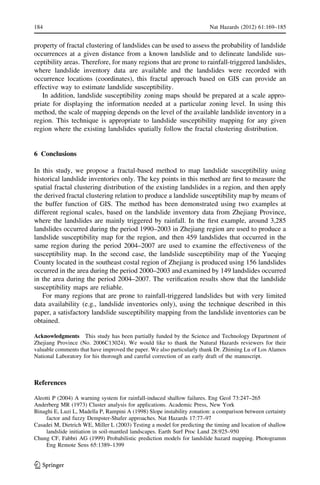
For the previously mentioned P(r) map (smoothed), the Wi values (W1 = 38,540.97,
W2 = 16,985.69, W3 = 15,591.37, W4 = 10,706.27, and W5 = 2,530.12) can be deter-
mined from Eq. (4) for k = 5. From this, the range of x values is divided into five groups
(x B 3.37, 3.37 x B 6.75, 6.75 x B 10.13, 10.13 xB13.51, and 13.51 xB16.88),
which classified the landslide susceptibility into 5 levels: very low zone (I), low zone (II),
moderate zone (III), high zone (IV), and very high zone (V). The flow chart for producing a
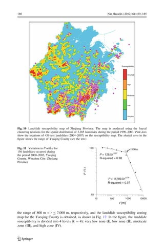
landslide susceptibility zoning map is shown in Fig. 9 and the resulting landslide sus-
ceptibility zoning map is illustrated in Fig. 10.
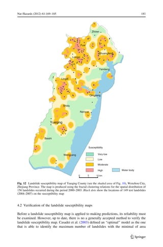
In the previous example, our method has been tested on the entire continental region of
Zhejiang Province. In the following, we apply the method to a relatively small area, i.e.,
the Yueqing County (see the shaded area in Fig. 10) in Wenzhou city.
In the Yueqing area, about 156 landslides occurred during period 2000–2003. When the
box-counting method is applied to the 156 landslides, a 25 9 25 m grid cell is taken as the
minimum cell covering the area. The ratio of the landslides occurring at a given location
over the total number of landslides (P) as a function of distance (r) from a known landslide
is plotted in Fig. 11 and two line segments in the figure may be fitted using Eq. (2), i.e., the
relationship between P and r is as follows
P ¼
128:5rÀ0:07
ð25 mr 800 m)
15789:0rÀ0:79
ð800 mr 7000 m)
&
ð5Þ
The slopes of the two line segments in Fig. 11 are calculated using the least square fitting
method; slope D = 0.07 within a range of 25–800 m and slope D = 0.79 within a range of
800–7,000 m. The fractal clustering distribution has different scaling exponents at two
different scaling lengths, a result which is different from that obtained for the entire region
of Zhejiang (see Fig. 8). Because the types of landslides in the Yueqing area are similar to
those of landslides in other region of Zhejiang and mainly belong to shallow landslides and
are triggered by rainfall, we attribute this to the fact that, in the box-counting method, the
minimum cell needed for covering the Yueqing County is much smaller than that for the
entire region of Zhejiang where landslides with distances smaller than 1 km are considered
as a single landslide.
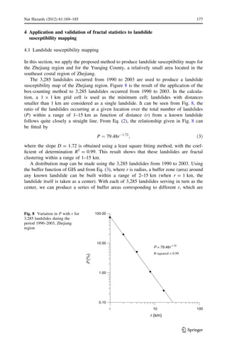
178 Nat Hazards (2012) 61:169–185
123](https://image.slidesharecdn.com/fractallandslide-160106131727/85/Fractals-and-Landslides-10-320.jpg)


This document describes a new fractal approach for landslide susceptibility mapping using only historical landslide inventory data. The method measures the spatial clustering of past landslides at different scales using a box-counting technique. It then applies the derived fractal clustering relationship to produce a landslide susceptibility map in a GIS. The method is demonstrated on landslide data from China's Zhejiang Province, producing a susceptibility map that is validated against later landslides. The results show the fractal method can reliably map susceptibility using limited landslide inventory data alone.


