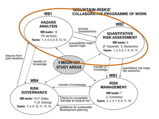
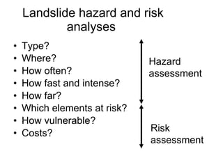
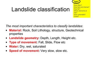
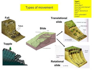
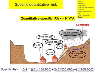
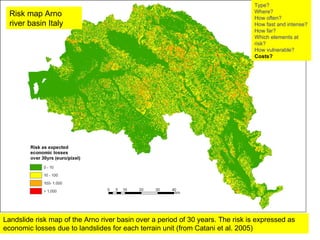
Contd…  Laprak Landslide  The Landslide problem
Theo van Asch: Faculty of Geosciences Utrecht    in collaboration with  Cees van Westen and Dinand Alkma  ITC Enschede
Landslide Definition: Landslide is defined as the  movement of a mass  of rock, debris or earth down the slope, when the  driving (gravity) forces  exceeds the  frictional resistance  of the material.
Landslide hazard analysis  Landslide risk analysis .  Landslide risk management R isk governance The Landslide problem
 
Landslide hazard and risk analyses  Type? Where? How often? How fast and intense? How far? Which elements at risk? How vulnerable?  Costs?  Hazard assessment   Risk assessment
Landslide classification The most important characteristics to classify landslides :   Material:   Rock, Soil Lithology, structure, Geotechnical properties Landslide geometry :  Depth, Length, Height etc. Type of movement :  Fall, Slide, Flow etc Water :  Dry, wet, saturated Speed of movement :  Very slow, slow etc. Type? Where? How often? How fast and intense? How far? Which elements at risk? How vulnerable?  Costs?
Types of movement Fall Topple Slide Rotational slide Translational slide Type? Where? How often? How fast and intense? How far? Which elements at risk? How vulnerable?  Costs?
Flow Debris/Mud Flow Debris avalanche
Velocity of  mass movement related to water content and type   Type? Where? How often? How fast and intense? How far? Which elements at risk? How vulnerable?  Costs?
Translational slide Type? Where? How often? How fast and intense? How far? Which elements at risk? How vulnerable?  Costs?
Rotational slide (Slump) Type? Where? How often? How fast and intense? How far? Which elements at risk? How vulnerable?  Costs?
debris flow Type? Where? How often? How fast and intense? How far? Which elements at risk? How vulnerable?  Costs?
Type? Where? How often? How fast and intense? How far? Which elements at risk? How vulnerable?  Costs? debris flow
Type? Where? How often? How fast and intense? How far? Which elements at risk? How vulnerable?  Costs?
Debris avalanche Type? Where? How often? How fast and intense? How far? Which elements at risk? How vulnerable?  Costs?
Spatial probability of occurrence  Landslide  susceptibility  maps Landslide susceptibility Type? Where? How often? How fast and intense? How far? Which elements at risk? How vulnerable?  Costs?
How to make a susceptibility map? Make a landslide map Determine causing /triggering factors Make (statistical) correlation between landslide occurrence and factors Make a zonation map with probability of occurrence of future landslides.  Landslide susceptibility Type? Where? How often? How fast and intense? How far? Which elements at risk? How vulnerable?  Costs?
Landslide maps   Type? Where? How often? How fast and intense? How far? Which elements at risk? How vulnerable?  Costs?
Use of factor maps   .   Slope classes Landuse Aspect classes Soil depth Lithology Distance from river Weight maps Susceptibility map Total weight Statistical correlation techniques with landslide map Elevation  Type? Where? How often? How fast and intense? How far? Which elements at risk? How vulnerable?  Costs?
Susceptibility   map Type? Where? How often? How fast and intense? How far? Which elements at risk? How vulnerable?  Costs?
The landslide hazard map Susceptibility map  plus  temporal frequency  Landslide  hazard  maps Type? Where? How often? How fast and intense? How far? Which elements at risk? How vulnerable?  Costs?
1D formulation The driving force and frictional resistance  The role of deterministic models Deterministic (physical ) models are useful to determine the temporal frequency of slope instability  Type? Where? How often? How fast and intense? How far? Which elements at risk? How vulnerable?  Costs? x z h i 1m  1/cos  h i-1 h i+1  fl,, c ,     x  x  d i-1
Driving forces  Resisting forces  Groundwater recharge  Precipitation /percolation  Safety factor<1 Slope triggered by rain   Coupled hydrological-slope stability models calculates  over time:  Temporal frequency of instability  Type? Where? How often? How fast and intense? How far? Which elements at risk? How vulnerable?  Costs?
The role of deterministic models Deterministic (physical ) models are also useful to determine the speed extent and impact of landslides Type? Where? How often? How fast and intense? How far? Which elements at risk? How vulnerable?  Costs?
Rapid gravitational   debris/mudflows Source area  Rema ître 2006 Faucon creek French Alps  2003 event Type? Where? How often? How fast and intense? How far? Which elements at risk? How vulnerable?  Costs?
Rapid gravitational   debris/mudflows Transportation and deposition area  Type? Where? How often? How fast and intense? How far? Which elements at risk? How vulnerable?  Costs?
Faucon creek French Alps: 2003 event   Rapid gravitational   debris/mudflows Source area  Type? Where? How often? How fast and intense? How far? Which elements at risk? How vulnerable?  Costs?
Faucon creek French Alps: 2003 event   Rapid gravitational   debris/mudflows Scouring in transportation area  Type? Where? How often? How fast and intense? How far? Which elements at risk? How vulnerable?  Costs?
Rapid gravitational   debris/mudflows Deposition  area  Faucon creek French Alps: 2003 event   Type? Where? How often? How fast and intense? How far? Which elements at risk? How vulnerable?  Costs?
Coh =  1 kPa , K =  5.0E-2  m kPa.s -1 Average velocity:  6 m s -1 Model simulation in deposition area  Faucon Barcelonette  Faucon creek French Alps: 2003 event   Type? Where? How often? How fast and intense? How far? Which elements at risk? How vulnerable?  Costs?
Wartschenbach 1997 (Austria) Rapid gravitational   debris/mudflows Deposition  area  Type? Where? How often? How fast and intense? How far? Which elements at risk? How vulnerable?  Costs?
Type? Where? How often? How fast and intense? How far? Which elements at risk? How vulnerable?  Costs?
Simulation of an earthflow Type? Where? How often? How fast and intense? How far? Which elements at risk? How vulnerable?  Costs?
All objects, persons, animals, activities and processes that may be adversely affected by hazardous phenomena, in a particular area, either directly or indirectly.  What are  elements at risk? Type? Where? How often? How fast and intense? How far? Which elements at risk ? How vulnerable?  Costs?
Different elements at risk Physical elements   Housing Infrastructure (roads, railways.airport etc ) Critical facilities (schools hospitals police..etc ) Utilities (Power supply ,transport services,governmental services..etc) Economic elements   Buseness and trade activities, access to work,agricultural land, work force,  Societal  elements   Moving people, vulnerable age categories,Low income groups,homeless people, disabled ,gender Environmental elements   Resources: like air, water, fauna, flora ,biodiversity,  Type? Where? How often? How fast and intense? How far? Which elements at risk ? How vulnerable?  Costs?
Buildings are one of the most important groups of elements at risk.  They house the population.  The behavior of a building under a hazard event, determines whether the people in the building might be injured or killed.  Important elements:buildings Type? Where? How often? How fast and intense? How far? Which elements at risk? How vulnerable?  Costs?
Important element:population Static   characteristics:   Relate to number of inhabitants, the densities of the population and the age compositions; Dynamic characteristics:   Relate to the activity patterns of the people, and the distribution of the population in space and time.  One of the most important socio-cultural vulnerability indicators is the time-distribution of the population. Type? Where? How often? How fast and intense? How far? Which elements at risk ? How vulnerable?  Costs?
Rockfall on school:  1400 deaths Landslide on neighborhood: 800 deaths Flood caused by a landslide dam Debris flow on 14/9 destroying  the remains of Old Beichuan City of  Beichuan, deserted after the earthquake on 12 May Type? Where? How often? How fast and intense? How far? Which elements at risk ? How vulnerable?  Costs?
Types of vulnerability Physical Vulnerability : Economic vulnerability:   Social vulnerability Environmental vulnerability Type? Where? How often? How fast and intense? How far? Which elements at risk? How vulnerable?  Costs?
Types of vulnerability Type? Where? How often? How fast and intense? How far? Which elements at risk? How vulnerable?  Costs?
Vulnerability curves:   Are constructed on the basis of the relation between hazard intensities and damage data Relative curves : they show in  the degree of damage (between 0 and 1) of a property How to express physical vulnerability? Low vulnerability curve   High vulnerability curve Type? Where? How often? How fast and intense? How far? Which elements at risk? How vulnerable?  Costs?
Landslide vulnerability assessment is still in its infant stages   There is a wide variety of processes  Lack of historical damage databases Vulnerability assessment  for mass movements  Type? Where? How often? How fast and intense? How far? Which elements at risk? How vulnerable?  Costs?
Damages due to various landslides. Type? Where? How often? How fast and intense? How far? Which elements at risk? How vulnerable?  Costs?
Quantitative risk assessment Risk =  Hazard  *  Vulnerability  *  Amount = Temporal frequency (H) *  Degree  of  loss  to elements at risk (V) *Cost quantification of elements at risk (A)   Quantitative Risk Type? Where? How often? How fast and intense? How far? Which elements at risk? How vulnerable?  Costs?
Specific quantitative  risk Specific Risk  =0.1 * ((0.1 *50.000)+(0.5*200.000)+(1*100.000)) Landslide Quantitative specific  Risk = H*V*A Type? Where? How often? How fast and intense? How far? Which elements at risk? How vulnerable?  Costs? A=US $ 50.000 V = 0.1 RP = 10 years H=0.1 A=US $ 200.000 V = 0.5 V = 1 A=US $ 100.000
Landslide risk map of the Arno river basin over a period of 30 years. The risk is expressed as economic losses due to landslides for each terrain unit (from Catani et al. 2005) Type? Where? How often? How fast and intense? How far? Which elements at risk? How vulnerable?  Costs? Risk map Arno river basin Italy

WS 18 landslides Theo van Asch

  • 1.
    Contd… LaprakLandslide The Landslide problem
  • 2.
    Theo van Asch:Faculty of Geosciences Utrecht in collaboration with Cees van Westen and Dinand Alkma ITC Enschede
  • 3.
    Landslide Definition: Landslideis defined as the movement of a mass of rock, debris or earth down the slope, when the driving (gravity) forces exceeds the frictional resistance of the material.
  • 4.
    Landslide hazard analysis Landslide risk analysis . Landslide risk management R isk governance The Landslide problem
  • 5.
  • 6.
    Landslide hazard andrisk analyses Type? Where? How often? How fast and intense? How far? Which elements at risk? How vulnerable? Costs? Hazard assessment Risk assessment
  • 7.
    Landslide classification Themost important characteristics to classify landslides : Material: Rock, Soil Lithology, structure, Geotechnical properties Landslide geometry : Depth, Length, Height etc. Type of movement : Fall, Slide, Flow etc Water : Dry, wet, saturated Speed of movement : Very slow, slow etc. Type? Where? How often? How fast and intense? How far? Which elements at risk? How vulnerable? Costs?
  • 8.
    Types of movementFall Topple Slide Rotational slide Translational slide Type? Where? How often? How fast and intense? How far? Which elements at risk? How vulnerable? Costs?
  • 9.
    Flow Debris/Mud FlowDebris avalanche
  • 10.
    Velocity of mass movement related to water content and type Type? Where? How often? How fast and intense? How far? Which elements at risk? How vulnerable? Costs?
  • 11.
    Translational slide Type?Where? How often? How fast and intense? How far? Which elements at risk? How vulnerable? Costs?
  • 12.
    Rotational slide (Slump)Type? Where? How often? How fast and intense? How far? Which elements at risk? How vulnerable? Costs?
  • 13.
    Rotational slide (Slump)Type? Where? How often? How fast and intense? How far? Which elements at risk? How vulnerable? Costs?
  • 14.
    debris flow Type?Where? How often? How fast and intense? How far? Which elements at risk? How vulnerable? Costs?
  • 15.
    Type? Where? Howoften? How fast and intense? How far? Which elements at risk? How vulnerable? Costs? debris flow
  • 16.
    Type? Where? Howoften? How fast and intense? How far? Which elements at risk? How vulnerable? Costs?
  • 17.
    Debris avalanche Type?Where? How often? How fast and intense? How far? Which elements at risk? How vulnerable? Costs?
  • 18.
    Debris avalanche Type?Where? How often? How fast and intense? How far? Which elements at risk? How vulnerable? Costs?
  • 19.
    Spatial probability ofoccurrence Landslide susceptibility maps Landslide susceptibility Type? Where? How often? How fast and intense? How far? Which elements at risk? How vulnerable? Costs?
  • 20.
    How to makea susceptibility map? Make a landslide map Determine causing /triggering factors Make (statistical) correlation between landslide occurrence and factors Make a zonation map with probability of occurrence of future landslides. Landslide susceptibility Type? Where? How often? How fast and intense? How far? Which elements at risk? How vulnerable? Costs?
  • 21.
    Landslide maps Type? Where? How often? How fast and intense? How far? Which elements at risk? How vulnerable? Costs?
  • 22.
    Landslide maps Type? Where? How often? How fast and intense? How far? Which elements at risk? How vulnerable? Costs?
  • 23.
    Use of factormaps . Slope classes Landuse Aspect classes Soil depth Lithology Distance from river Weight maps Susceptibility map Total weight Statistical correlation techniques with landslide map Elevation Type? Where? How often? How fast and intense? How far? Which elements at risk? How vulnerable? Costs?
  • 24.
    Susceptibility map Type? Where? How often? How fast and intense? How far? Which elements at risk? How vulnerable? Costs?
  • 25.
    The landslide hazardmap Susceptibility map plus temporal frequency Landslide hazard maps Type? Where? How often? How fast and intense? How far? Which elements at risk? How vulnerable? Costs?
  • 26.
    1D formulation Thedriving force and frictional resistance The role of deterministic models Deterministic (physical ) models are useful to determine the temporal frequency of slope instability Type? Where? How often? How fast and intense? How far? Which elements at risk? How vulnerable? Costs? x z h i 1m  1/cos  h i-1 h i+1  fl,, c ,   x  x  d i-1
  • 27.
    Driving forces Resisting forces Groundwater recharge Precipitation /percolation Safety factor<1 Slope triggered by rain Coupled hydrological-slope stability models calculates over time: Temporal frequency of instability Type? Where? How often? How fast and intense? How far? Which elements at risk? How vulnerable? Costs?
  • 28.
    The role ofdeterministic models Deterministic (physical ) models are also useful to determine the speed extent and impact of landslides Type? Where? How often? How fast and intense? How far? Which elements at risk? How vulnerable? Costs?
  • 29.
    Rapid gravitational debris/mudflows Source area Rema ître 2006 Faucon creek French Alps 2003 event Type? Where? How often? How fast and intense? How far? Which elements at risk? How vulnerable? Costs?
  • 30.
    Rapid gravitational debris/mudflows Transportation and deposition area Type? Where? How often? How fast and intense? How far? Which elements at risk? How vulnerable? Costs?
  • 31.
    Faucon creek FrenchAlps: 2003 event Rapid gravitational debris/mudflows Source area Type? Where? How often? How fast and intense? How far? Which elements at risk? How vulnerable? Costs?
  • 32.
    Faucon creek FrenchAlps: 2003 event Rapid gravitational debris/mudflows Scouring in transportation area Type? Where? How often? How fast and intense? How far? Which elements at risk? How vulnerable? Costs?
  • 33.
    Rapid gravitational debris/mudflows Deposition area Faucon creek French Alps: 2003 event Type? Where? How often? How fast and intense? How far? Which elements at risk? How vulnerable? Costs?
  • 34.
    Coh = 1 kPa , K = 5.0E-2 m kPa.s -1 Average velocity: 6 m s -1 Model simulation in deposition area Faucon Barcelonette Faucon creek French Alps: 2003 event Type? Where? How often? How fast and intense? How far? Which elements at risk? How vulnerable? Costs?
  • 35.
    Wartschenbach 1997 (Austria)Rapid gravitational debris/mudflows Deposition area Type? Where? How often? How fast and intense? How far? Which elements at risk? How vulnerable? Costs?
  • 36.
    Type? Where? Howoften? How fast and intense? How far? Which elements at risk? How vulnerable? Costs?
  • 37.
    Simulation of anearthflow Type? Where? How often? How fast and intense? How far? Which elements at risk? How vulnerable? Costs?
  • 38.
    All objects, persons,animals, activities and processes that may be adversely affected by hazardous phenomena, in a particular area, either directly or indirectly. What are elements at risk? Type? Where? How often? How fast and intense? How far? Which elements at risk ? How vulnerable? Costs?
  • 39.
    Different elements atrisk Physical elements Housing Infrastructure (roads, railways.airport etc ) Critical facilities (schools hospitals police..etc ) Utilities (Power supply ,transport services,governmental services..etc) Economic elements Buseness and trade activities, access to work,agricultural land, work force, Societal elements Moving people, vulnerable age categories,Low income groups,homeless people, disabled ,gender Environmental elements Resources: like air, water, fauna, flora ,biodiversity, Type? Where? How often? How fast and intense? How far? Which elements at risk ? How vulnerable? Costs?
  • 40.
    Buildings are oneof the most important groups of elements at risk. They house the population. The behavior of a building under a hazard event, determines whether the people in the building might be injured or killed. Important elements:buildings Type? Where? How often? How fast and intense? How far? Which elements at risk? How vulnerable? Costs?
  • 41.
    Important element:population Static characteristics: Relate to number of inhabitants, the densities of the population and the age compositions; Dynamic characteristics: Relate to the activity patterns of the people, and the distribution of the population in space and time. One of the most important socio-cultural vulnerability indicators is the time-distribution of the population. Type? Where? How often? How fast and intense? How far? Which elements at risk ? How vulnerable? Costs?
  • 42.
    Rockfall on school: 1400 deaths Landslide on neighborhood: 800 deaths Flood caused by a landslide dam Debris flow on 14/9 destroying the remains of Old Beichuan City of Beichuan, deserted after the earthquake on 12 May Type? Where? How often? How fast and intense? How far? Which elements at risk ? How vulnerable? Costs?
  • 43.
    Types of vulnerabilityPhysical Vulnerability : Economic vulnerability: Social vulnerability Environmental vulnerability Type? Where? How often? How fast and intense? How far? Which elements at risk? How vulnerable? Costs?
  • 44.
    Types of vulnerabilityType? Where? How often? How fast and intense? How far? Which elements at risk? How vulnerable? Costs?
  • 45.
    Vulnerability curves: Are constructed on the basis of the relation between hazard intensities and damage data Relative curves : they show in the degree of damage (between 0 and 1) of a property How to express physical vulnerability? Low vulnerability curve High vulnerability curve Type? Where? How often? How fast and intense? How far? Which elements at risk? How vulnerable? Costs?
  • 46.
    Landslide vulnerability assessmentis still in its infant stages There is a wide variety of processes Lack of historical damage databases Vulnerability assessment for mass movements Type? Where? How often? How fast and intense? How far? Which elements at risk? How vulnerable? Costs?
  • 47.
    Damages due tovarious landslides. Type? Where? How often? How fast and intense? How far? Which elements at risk? How vulnerable? Costs?
  • 48.
    Damages due tovarious landslides. Type? Where? How often? How fast and intense? How far? Which elements at risk? How vulnerable? Costs?
  • 49.
    Quantitative risk assessmentRisk = Hazard * Vulnerability * Amount = Temporal frequency (H) * Degree of loss to elements at risk (V) *Cost quantification of elements at risk (A) Quantitative Risk Type? Where? How often? How fast and intense? How far? Which elements at risk? How vulnerable? Costs?
  • 50.
    Specific quantitative risk Specific Risk =0.1 * ((0.1 *50.000)+(0.5*200.000)+(1*100.000)) Landslide Quantitative specific Risk = H*V*A Type? Where? How often? How fast and intense? How far? Which elements at risk? How vulnerable? Costs? A=US $ 50.000 V = 0.1 RP = 10 years H=0.1 A=US $ 200.000 V = 0.5 V = 1 A=US $ 100.000
  • 51.
    Landslide risk mapof the Arno river basin over a period of 30 years. The risk is expressed as economic losses due to landslides for each terrain unit (from Catani et al. 2005) Type? Where? How often? How fast and intense? How far? Which elements at risk? How vulnerable? Costs? Risk map Arno river basin Italy