Four Regions of Texas
•Download as PPT, PDF•
5 likes•22,712 views

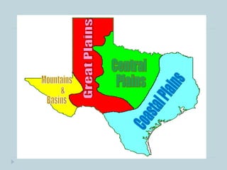
The document summarizes the four main geographic regions of Texas: the Coastal Plains, Central Plains, Great Plains, and Mountains and Basins. It provides key details about each region, including major cities, natural resources, industries, climate, and other important facts. The Coastal Plains region contains the largest cities and ports along the Gulf of Mexico and is the most populated. The Central Plains have thick grasses, limestone resources, and ranchlands. The Great Plains rely on irrigation for farming due to low rainfall. The Mountains and Basins have many mountains and deserts, low rainfall, and include El Paso on the Mexican border.
Report
Share
Report
Share

Recommended
Texas Regions, Industries (past & present) and Subsistence Economy
Texas has 4 regions: Mountains and Basins, Great Plains, Central Plains, and Coastal Plains. Each region's economy has shifted over time from a focus on ranching and agriculture in the past to more diverse industries today, such as oil and gas, wind farms, commercial agriculture, aerospace, technology, and education in the Coastal Plains region.
Texas Regions
The document describes the four major regions of Texas: the Gulf Coastal Plains, North Central Plains, High Plains, and Mountains and Basins Region. It provides details on the location, climate, agriculture, resources, and major cities for each region. The regions vary significantly from one another in terms of climate, vegetation, and economic activities due to differences in geography, weather patterns, and natural resources.
TX History Ch 3.2
The Gulf Coastal Plain region of Texas is divided into 5 subregions. The Piney Woods subregion is heavily forested and located in eastern Texas. It contains the Big Thicket National Preserve. The Gulf Coastal Plain subregion near the coast contains many bayous and includes the cities of Houston and Corpus Christi. Houston is the largest city in Texas. The South Texas Plains subregion includes the Rio Grande Valley and its largest city is San Antonio. The Post Oak Belt subregion contains lignite and its largest city is Bryan-College Station. The Blackland Prairie subregion has rich black soil suitable for farming and contains the Dallas-Fort Worth metropolitan area.
TX History Ch 2.1
Texas has a variety of landforms including plains, hills, plateaus, and mountain ranges. The plains are flat or gently rolling land while the plateaus are flat elevated land that drop sharply on one or more sides. Texas' rivers and streams eventually flow into the Gulf of Mexico, with most located in East Texas. The major river systems include the Rio Grande, Colorado, Brazos, and Nueces. Texas has few natural lakes but many artificial reservoirs used for water storage and irrigation. Underground aquifers like the Ogallala and Edwards aquifers provide water for homes, farms, and industry across much of the state.
Texas
Texas is the second largest and second most populous state in the US. It has a diverse climate and terrain, being home to forests, grasslands, deserts, and coastlines. Texas has a long history, first being settled by Native Americans and later becoming an independent republic before joining the US in 1845. It has a strong culture and economy today.
North America
North America is the third largest continent, located in the Northern and Western Hemispheres and covering over 9 million square miles. It includes 23 countries as well as Caribbean islands, with Canada, the US, and Mexico as the largest nations. Central America connects North America to South America and includes 7 countries. Key geographic features include the Rocky Mountains, Great Plains, Mississippi and Missouri River systems, Great Lakes, and Gulf of Mexico.
TX History Ch 3.1
Texas has several regions with different landforms and climates. The state is often divided into northern, southern, eastern, and western regions based on location, but some areas like Ft. Worth are considered part of the west due to cultural ties. Parts of Texas fall into four natural regions: the Gulf Coastal Plain, Central Plains, Great Plains, and Intermountain Basins and Plateaus.
TX History Ch 3.3
The Central Plains region of Texas includes the Grand Prairie and Cross Timbers subregions. The Grand Prairie has thin soil better suited for livestock grazing than farming, with Fort Worth as the largest city. The Cross Timbers is divided into eastern and western belts by different tree species and separates the Grand Prairie from the Rolling Plains further west, where cattle ranching and farming of cotton and grains are important economic activities.
North america
North America is located between the Pacific Ocean to the west, the Atlantic Ocean to the east, and the Arctic Ocean to the north. It contains several countries including the USA, Canada, and Mexico. The climate and environment varies greatly from region to region, ranging from tropical rainforests to grasslands to tundra. Many different animal species have adapted to these diverse landscapes across the continent.
North America
Contains:
1. People of North America
2. Cultures
3. Waterway System
4. Countries in North America
5. Flags
Age of contact- Early Exploration in Texas
Conquistadors from Spain explored and conquered areas in America in the 16th century, motivated by goals of spreading Christianity (God), finding gold, and achieving glory. While initially more focused on Mexico, the Spanish became concerned about French colonization efforts in Texas in the 18th century, renewing their own colonization attempts to maintain control over the territory.
U.S. State Presentation - Texas
Texas is the second largest state by both area and population. It has a diverse climate and economy, being a major producer of oil, gas, and agriculture. Some of its iconic attractions include the Alamo in San Antonio, the River Walk, and its state capital building in Austin. The state has a long history dating back to Spanish exploration and its independence from Mexico, and today has a mix of urban centers like Houston, Dallas, Austin and San Antonio alongside wide-open rural landscapes.
North carolina geography
This document provides information about the key geographic regions of North Carolina: Tidewater, Coastal Plain, Piedmont, and Mountains. The Tidewater region borders the Atlantic Ocean and is characterized by barrier islands, sounds, and a mild climate. The Coastal Plain has rich soil suitable for farming. The Piedmont region features hills and red clay soil and contains over half of North Carolina's forests. The mountainous region includes the Blue Ridge Mountains, with Mount Mitchell being the highest point in Eastern US.
Regions Of The United States
This document provides an overview of the different regions of the United States by presenting information on the states included in each region, key facts about the region, and resources for further information. The regions covered are the Northeast, Southeast, Midwest, Southwest, and West. For each region, the document lists the included states and provides 1-2 sentences on geographic, demographic, or cultural characteristics that define each area.
Arkansas
Arkansas has many natural resources like coal and diamonds. The state is mostly forested and has some popular tourist attractions such as Lover's Leap Lookout. Arkansas has a humid subtropical climate with warm summers and mild winters. Some famous people from Arkansas include Bill Clinton and Johnny Cash. The state's economy relies on agriculture, tourism, and natural gas mining.
Regions of the United States: The Northeast
A Power point about the people, landforms, states, etc. of the Northeast Region of the United States.
South carolina
South Carolina has a long history as one of the original 13 colonies. It split into North and South Carolina in 1710 and became a state in 1788. Some key facts about South Carolina include its capital of Columbia, state bird Carolina Wren, and tourist attractions like beaches, aquariums, and water parks. The state has a humid subtropical climate and is known for industries like tobacco, soybeans, cotton, fishing and tourism. Famous people from South Carolina include politician John C. Calhoun and musician James Brown.
TX History Ch 9.4
The document summarizes the government and society of Texas under Mexican rule after Mexico became a republic in 1824. It adopted a constitution that gave limited powers to the central government and broad authority to states, similar to the US Constitution. However, state lawmakers rather than citizens elected the president, and there was no separation of church and state. The constitution united Texas and Coahuila as a single state, but most Texans disliked this due to lack of local control and the distant capital. Tensions increased over slavery as US settlers brought slaves despite Mexican laws restricting and then banning the practice.
United States Climate
The document summarizes several climate zones found within the United States, including humid continental, humid subtropical, steppe, desert, high latitude, and tropical climates. It notes that humid continental climates are found in the northern Great Plains and Atlantic coast with cold winters and hot summers. Humid subtropical climates cover the Southern Great Plains and Southeastern states, featuring milder winters and hot, humid summers prone to tropical storms. Steppe and desert climates are limited to the western United States, with steppe receiving just enough rain to support grasses and deserts like Death Valley experiencing extremely high summer temperatures. Alaska has a high latitude climate that is mostly subarctic and tundra with
The northeastern united states
The document provides an overview of the Northeast region of the United States, dividing it into New England and Middle Atlantic states. It describes the states that make up each subregion and their physical geography, climate, and economy. A key point is that the Northeast has the highest population density and urbanization in the country, with many cities founded as colonial ports that later grew into centers of industry and finance, forming a megalopolis from Boston to Washington D.C. The economies of New England and the Middle Atlantic states revolve around services, education, manufacturing, agriculture, fishing, and resource extraction industries like coal mining that developed from the region's physical environment and history.
Texas
Texas is located in the southern United States. It has the second largest population and is the second largest state by size. The climate varies widely from hot and dry in the west to hot and humid in the east. Major industries include energy, aerospace, technology, and healthcare. Famous Texans include Willie Nelson, Janis Joplin, and Lyndon B. Johnson. The state's capital is Austin.
geography of Canada.
Canada is located in northern North America, bordered by three oceans (the Arctic, Atlantic, and Pacific) and one country (the United States) to the south. While Canada has a large land area, most of its population lives near the southern border due to the harsh climate further north. The country's location and natural resources have contributed to its development and trade.
Central America
Central America is a region connecting North and South America, comprising Mexico, Central American countries, and the Caribbean islands. It has a population of over 188 million and is geographically, culturally, and linguistically diverse. Central America experienced colonial rule by European powers and domination by the United States through interventions and support of authoritarian regimes. More recently, neoliberal economic policies promoted by institutions like the IMF have led to increased inequality, poverty, crime, and social unrest in the region.
The United state of America
The United States is located in North America with 50 states and borders Mexico and Canada. It has a diverse population of over 300 million people and its capital and largest city is Washington D.C. The U.S. has a strong economy and is a world leader in areas like technology and military defense. American culture is influenced by its history of immigration and values like equality and justice.
Geography North America
The document summarizes the major geographic features and natural resources of North America. It describes the various mountain ranges, plains, basins and plateaus that were formed by tectonic activity and erosion. It notes the continent's wealth of natural resources like gold, silver and food and how resources have contributed to the economic strength of the United States and Canada. Major rivers like the Mississippi and St. Lawrence are also outlined for their importance to trade and transportation.
North carolina geography
North Carolina has four geographic regions: the Tidewater region along the coast bordering the Atlantic Ocean, including barrier islands like the Outer Banks; the Coastal Plain region inland known for rich farmland; the Piedmont region with red clay soil including the city where the author lives; and the western Mountain region containing the Blue Ridge and Appalachian Mountains, home to the tallest peak east of the Rockies. The state has varied terrain, climate, and economic activities across its four main geographic areas.
Texas Symbols - LaRocque
Texas is known as the Lone Star State with Austin as its capital city. It has a population of over 20 million people and its largest city is Houston. Texas has a diverse economy focused on petroleum, natural gas, farming and ranching. Some key facts about Texas include that it borders Mexico and four other states, was originally inhabited by Caddo Indians, and has many iconic symbols like the bluebonnet flower and mockingbird.
Arkansas
Arkansas is known as the Natural State. It has a population of around 2.7 million people and its capital is Little Rock. Some key facts about Arkansas are that it is a top producer of food, lumber, cotton, rice and soybeans. It also contains the only active diamond mine in North America. The state has a temperate climate and abundant natural resources like forests, lakes and wildlife. Popular tourist attractions include state parks, hunting and visiting the diamond mine.
Texas symbols 1
The document summarizes key symbols of the state of Texas in 3 sentences or less per symbol. It discusses the cactus, mockingbird, armadillo, pecan, bluebonnet, and monarch butterfly as the state plant, bird, small mammal, nut, flower, and insect. It provides some key facts about each symbol such as their physical characteristics, when they were designated as state symbols, and cultural significance to Texas.
Texas powerpoint
Texas was once an independent country and has been part of 6 countries throughout history. It has a diverse landscape and economy centered around agriculture, energy, and technology. Some key aspects of Texas culture include cowboy culture, country music, barbecue, American football, and NASA's Johnson Space Center located in Houston.
More Related Content
What's hot
North america
North America is located between the Pacific Ocean to the west, the Atlantic Ocean to the east, and the Arctic Ocean to the north. It contains several countries including the USA, Canada, and Mexico. The climate and environment varies greatly from region to region, ranging from tropical rainforests to grasslands to tundra. Many different animal species have adapted to these diverse landscapes across the continent.
North America
Contains:
1. People of North America
2. Cultures
3. Waterway System
4. Countries in North America
5. Flags
Age of contact- Early Exploration in Texas
Conquistadors from Spain explored and conquered areas in America in the 16th century, motivated by goals of spreading Christianity (God), finding gold, and achieving glory. While initially more focused on Mexico, the Spanish became concerned about French colonization efforts in Texas in the 18th century, renewing their own colonization attempts to maintain control over the territory.
U.S. State Presentation - Texas
Texas is the second largest state by both area and population. It has a diverse climate and economy, being a major producer of oil, gas, and agriculture. Some of its iconic attractions include the Alamo in San Antonio, the River Walk, and its state capital building in Austin. The state has a long history dating back to Spanish exploration and its independence from Mexico, and today has a mix of urban centers like Houston, Dallas, Austin and San Antonio alongside wide-open rural landscapes.
North carolina geography
This document provides information about the key geographic regions of North Carolina: Tidewater, Coastal Plain, Piedmont, and Mountains. The Tidewater region borders the Atlantic Ocean and is characterized by barrier islands, sounds, and a mild climate. The Coastal Plain has rich soil suitable for farming. The Piedmont region features hills and red clay soil and contains over half of North Carolina's forests. The mountainous region includes the Blue Ridge Mountains, with Mount Mitchell being the highest point in Eastern US.
Regions Of The United States
This document provides an overview of the different regions of the United States by presenting information on the states included in each region, key facts about the region, and resources for further information. The regions covered are the Northeast, Southeast, Midwest, Southwest, and West. For each region, the document lists the included states and provides 1-2 sentences on geographic, demographic, or cultural characteristics that define each area.
Arkansas
Arkansas has many natural resources like coal and diamonds. The state is mostly forested and has some popular tourist attractions such as Lover's Leap Lookout. Arkansas has a humid subtropical climate with warm summers and mild winters. Some famous people from Arkansas include Bill Clinton and Johnny Cash. The state's economy relies on agriculture, tourism, and natural gas mining.
Regions of the United States: The Northeast
A Power point about the people, landforms, states, etc. of the Northeast Region of the United States.
South carolina
South Carolina has a long history as one of the original 13 colonies. It split into North and South Carolina in 1710 and became a state in 1788. Some key facts about South Carolina include its capital of Columbia, state bird Carolina Wren, and tourist attractions like beaches, aquariums, and water parks. The state has a humid subtropical climate and is known for industries like tobacco, soybeans, cotton, fishing and tourism. Famous people from South Carolina include politician John C. Calhoun and musician James Brown.
TX History Ch 9.4
The document summarizes the government and society of Texas under Mexican rule after Mexico became a republic in 1824. It adopted a constitution that gave limited powers to the central government and broad authority to states, similar to the US Constitution. However, state lawmakers rather than citizens elected the president, and there was no separation of church and state. The constitution united Texas and Coahuila as a single state, but most Texans disliked this due to lack of local control and the distant capital. Tensions increased over slavery as US settlers brought slaves despite Mexican laws restricting and then banning the practice.
United States Climate
The document summarizes several climate zones found within the United States, including humid continental, humid subtropical, steppe, desert, high latitude, and tropical climates. It notes that humid continental climates are found in the northern Great Plains and Atlantic coast with cold winters and hot summers. Humid subtropical climates cover the Southern Great Plains and Southeastern states, featuring milder winters and hot, humid summers prone to tropical storms. Steppe and desert climates are limited to the western United States, with steppe receiving just enough rain to support grasses and deserts like Death Valley experiencing extremely high summer temperatures. Alaska has a high latitude climate that is mostly subarctic and tundra with
The northeastern united states
The document provides an overview of the Northeast region of the United States, dividing it into New England and Middle Atlantic states. It describes the states that make up each subregion and their physical geography, climate, and economy. A key point is that the Northeast has the highest population density and urbanization in the country, with many cities founded as colonial ports that later grew into centers of industry and finance, forming a megalopolis from Boston to Washington D.C. The economies of New England and the Middle Atlantic states revolve around services, education, manufacturing, agriculture, fishing, and resource extraction industries like coal mining that developed from the region's physical environment and history.
Texas
Texas is located in the southern United States. It has the second largest population and is the second largest state by size. The climate varies widely from hot and dry in the west to hot and humid in the east. Major industries include energy, aerospace, technology, and healthcare. Famous Texans include Willie Nelson, Janis Joplin, and Lyndon B. Johnson. The state's capital is Austin.
geography of Canada.
Canada is located in northern North America, bordered by three oceans (the Arctic, Atlantic, and Pacific) and one country (the United States) to the south. While Canada has a large land area, most of its population lives near the southern border due to the harsh climate further north. The country's location and natural resources have contributed to its development and trade.
Central America
Central America is a region connecting North and South America, comprising Mexico, Central American countries, and the Caribbean islands. It has a population of over 188 million and is geographically, culturally, and linguistically diverse. Central America experienced colonial rule by European powers and domination by the United States through interventions and support of authoritarian regimes. More recently, neoliberal economic policies promoted by institutions like the IMF have led to increased inequality, poverty, crime, and social unrest in the region.
The United state of America
The United States is located in North America with 50 states and borders Mexico and Canada. It has a diverse population of over 300 million people and its capital and largest city is Washington D.C. The U.S. has a strong economy and is a world leader in areas like technology and military defense. American culture is influenced by its history of immigration and values like equality and justice.
Geography North America
The document summarizes the major geographic features and natural resources of North America. It describes the various mountain ranges, plains, basins and plateaus that were formed by tectonic activity and erosion. It notes the continent's wealth of natural resources like gold, silver and food and how resources have contributed to the economic strength of the United States and Canada. Major rivers like the Mississippi and St. Lawrence are also outlined for their importance to trade and transportation.
North carolina geography
North Carolina has four geographic regions: the Tidewater region along the coast bordering the Atlantic Ocean, including barrier islands like the Outer Banks; the Coastal Plain region inland known for rich farmland; the Piedmont region with red clay soil including the city where the author lives; and the western Mountain region containing the Blue Ridge and Appalachian Mountains, home to the tallest peak east of the Rockies. The state has varied terrain, climate, and economic activities across its four main geographic areas.
Texas Symbols - LaRocque
Texas is known as the Lone Star State with Austin as its capital city. It has a population of over 20 million people and its largest city is Houston. Texas has a diverse economy focused on petroleum, natural gas, farming and ranching. Some key facts about Texas include that it borders Mexico and four other states, was originally inhabited by Caddo Indians, and has many iconic symbols like the bluebonnet flower and mockingbird.
Arkansas
Arkansas is known as the Natural State. It has a population of around 2.7 million people and its capital is Little Rock. Some key facts about Arkansas are that it is a top producer of food, lumber, cotton, rice and soybeans. It also contains the only active diamond mine in North America. The state has a temperate climate and abundant natural resources like forests, lakes and wildlife. Popular tourist attractions include state parks, hunting and visiting the diamond mine.
What's hot (20)
Viewers also liked
Texas symbols 1
The document summarizes key symbols of the state of Texas in 3 sentences or less per symbol. It discusses the cactus, mockingbird, armadillo, pecan, bluebonnet, and monarch butterfly as the state plant, bird, small mammal, nut, flower, and insect. It provides some key facts about each symbol such as their physical characteristics, when they were designated as state symbols, and cultural significance to Texas.
Texas powerpoint
Texas was once an independent country and has been part of 6 countries throughout history. It has a diverse landscape and economy centered around agriculture, energy, and technology. Some key aspects of Texas culture include cowboy culture, country music, barbecue, American football, and NASA's Johnson Space Center located in Houston.
Texas
Austin is the capital of Texas and has the state headquarters. There is a famous university in Texas. The document lists various state symbols of Texas including trees, flowers, birds, fish, seashells, foods, mammals, reptiles, gems, plants, and insects. It was created by Miriam Garcia and Nuria Heras.
Texas Slideshow
Texas has a diverse landscape ranging from mountains and forests to coastal plains. It has a mostly hot, dry climate but temperature varies by region. Six flags have flown over Texas since it was first settled by Americans in the 1820s when it was part of Mexico. Texas gained independence from Mexico and became a republic in 1836 after battles at the Alamo and San Jacinto, and it later joined the United States as a state in 1845. The state is known for oil and cattle production as well as native plants that thrive in its climate with little water.
Alamo Je
The document appears to be a quiz about Texas history from the early 1800s. It contains questions and answers about key events like the establishment of Austin's colony, the Battle of the Alamo, the Texas Declaration of Independence, and Sam Houston's election as the first president of the Republic of Texas. The quiz covers important figures, places, documents, and battles that were important to the founding of Texas as an independent republic after its revolution against Mexico.
La tierra es plana
El documento resume el primer capítulo del libro "La Tierra es Plana" de Thomas Friedman. Describe las tres etapas de la globalización según el autor (1.0, 2.0, 3.0) y cómo la globalización 3.0 ha aplanado el mundo al permitir que individuos de todo el mundo se conecten y compitan a nivel global gracias a la tecnología e internet. También menciona cómo países como China e India ahora compiten con las grandes potencias debido a los cambios traídos por la globalización.
Aspectos legales en Estados Unidos - Texas
Este documento proporciona una guía sobre los principales aspectos legales para invertir en Texas, Estados Unidos. Explica los diferentes tipos de sociedades disponibles, como corporaciones, compañías de responsabilidad limitada y sociedades, y los costos de registro asociados. También resume el régimen tributario federal y estatal, incluidos impuestos a la renta de las corporaciones, impuestos a la propiedad y sobre las ventas. Por último, destaca varios incentivos estatales para atraer inversiones, como exenciones tributarias para empresas manufactureras y
Reflexion sobre la tierra es plana
El documento resume 10 puntos clave sobre la evolución de la tecnología y la computación. Habla sobre la caída del Muro de Berlín y cómo esto facilitó la comunicación entre personas. También describe el desarrollo de Internet y los navegadores como Netscape y Mosaic. Explica cómo la tecnología ha permitido nuevas formas de trabajo y producción cinematográfica. Además, analiza el outsourcing de tareas informáticas a la India y el offshoring de fábricas a China. Finalmente, resalta el papel del Internet y
Estados unidos texas
Texas es el segundo estado más grande de Estados Unidos. Su capital es Austin y su ciudad más poblada es Houston. Texas alberga importantes atracciones turísticas como el Museo de Arte Moderno de Fort Worth, el Dallas World Aquarium, el puerto de Galveston y el River Walk en San Antonio. Texas también es conocido por su variedad de restaurantes y hoteles de lujo en ciudades como Houston.
Compras públicas base Federal BIDSYNC
Este documento proporciona información sobre cómo las empresas pueden postularse exitosamente a licitaciones públicas a nivel estatal y federal. Explica que el mercado de compras públicas vale aproximadamente $3 billones anualmente y ofrece varios ejemplos de licitaciones activas. También recomienda usar la plataforma BidSync para encontrar oportunidades y recibir notificaciones diarias, y proporciona consejos para preparar una propuesta exitosa como enviar toda la documentación requerida a tiempo.
Curso de-nutricion-ortomolecular
Este documento habla sobre la nutrición ortomolecular, una disciplina que suministra vitaminas, minerales y aminoácidos esenciales al cuerpo para mejorar la salud. Explica que se trata de añadir estos micronutrientes en la cantidad adecuada para ayudar al cuerpo sin perjudicarlo. El curso enseña los principios de esta terapia y cómo aplicarla de forma eficaz para mejorar el estado de salud.
La Realidad De La Tierra Hueca
Este documento presenta evidencia a favor de la teoría de la Tierra Hueca. Se discuten observaciones de la expedición del Almirante Byrd al Polo Norte en 1926 que sugieren que encontró un valle cálido y fértil debajo del hielo polar. También se citan pasajes bíblicos que mencionan seres que viven "debajo de la Tierra". La NASA supuestamente falsifica fotos para ocultar la existencia de soles internos en otros planetas. La teoría propone que la Tierra tiene aperturas polares que con
Libro topografia-basica
La topografía (del griego τόπος, ‘lugar’, y «-grafía», ‘descripción’) es la ciencia que estudia el conjunto de principios y procedimientos que tienen por objeto la representación gráfica de la superficie terrestre, con sus formas y detalles; tanto naturales como artificiales (véase planimetría y altimetría). Esta representación tiene lugar sobre superficies planas, limitándose a pequeñas extensiones de terreno, utilizando la denominación de «geodesia» para áreas mayores. De manera muy simple, puede decirse que para un topógrafo la Tierra es plana (geométricamente), mientras que para la geodesia no lo es.
Para eso se utiliza un sistema de coordenadas tridimensional, siendo la x y la y competencia de la planimetría, y la z de la altimetría.
Los mapas topográficos utilizan el sistema de representación de planos acotados, mostrando la elevación del terreno utilizando líneas que conectan los puntos con la misma cota respecto de un plano de referencia, denominadas curvas de nivel, en cuyo caso se dice que el mapa es hipsográfico. Dicho plano de referencia puede ser el nivel del mar, y en caso de serlo se hablará de altitudes en lugar de cotas.
Trabajos topográficos[editar]
La topografía es una ciencia geométrica aplicada a la descripción de la realidad física inmóvil circundante. Es plasmar en un plano topográfico la realidad vista en campo, en el ámbito rural o natural, de la superficie terrestre; en el ámbito urbano, es la descripción de los hechos existentes en un lugar determinado: muros, edificios, calles, entre otros.
Se puede dividir el trabajo topográfico como dos actividades congruentes: llevar "el terreno al gabinete" (mediante la medición de puntos o revelamiento, su archivo en el instrumental electrónico y luego su edición en la computadora) y llevar "el gabinete al terreno" (mediante el replanteo por el camino inverso, desde un proyecto en la computadora a la ubicación del mismo mediante puntos sobre el terreno). Los puntos relevados o replanteados tienen un valor tridimensional; es decir, se determina la ubicación de cada punto en el plano horizontal (de dos dimensiones, norte y este) y en altura (tercera dimensión).
La topografía no sólo se limita a realizar los levantamientos de campo en terreno sino que posee componentes de edición y redacción cartográfica, para que al confeccionar un plano se pueda entender el fonema representado a través del empleo de símbolos convencionales y estándares, previamente normados para la representación de los objetos naturales y antrópicos en los mapas o cartas topográficas. También se emplea en la ingeniería minera.
Obras civiles: edificios, puentes, etc.[editar]
La tarea del topógrafo es previa y/o durante un proyecto: un arquitecto, un ingeniero en Geomática y Topografía debe contar con un buen levantamiento plano-milimétrico ó tridimensional previo del terreno y de "hechos existentes" (elementos inmóviles y
Marco legal Indonesia
El documento proporciona una guía sobre los principales aspectos legales para invertir en Indonesia. Explica cómo establecer una empresa en el país, los incentivos fiscales y regionales disponibles, y otros incentivos como facilidades para la importación y derechos sobre la tierra. También incluye una lista de firmas legales reconocidas en Indonesia.
Verdades
Una pequeña demostraciones del porqué en USA son ricos y aquí, en España, nos sangran por todos lados. Desde hace seis años gracia a ZParo, desde luego
Marco legal california
Este documento presenta una guía legal sobre los principales aspectos legales para invertir en California, Estados Unidos. Explica los tipos de sociedades disponibles, como constituir una empresa, el régimen cambiario, tributario, laboral e incentivos a la inversión. En resumen, ofrece información sobre cómo establecer y operar un negocio en California en términos de estructuración societaria, trámites, impuestos y normativa laboral.
Metafisica
Este documento resume los orígenes y objetivos de la metafísica. La metafísica estudia los aspectos de la vida que no son explicables por la ciencia, como el espíritu y los principios fundamentales del ser. Immanuel Kant criticó la metafísica tradicional y estableció que los humanos solo pueden conocer los fenómenos, no las cosas en sí mismas. La metafísica debe limitarse al estudio de la relación entre fenómenos y cosas en sí.
Marco legal Nigeria
Conozca los aspectos más importantes del régimen legal de Nigeria. Este perfil le permitirá conocer de forma general del régimen cambiario, tributario, laboral, incentivos a la inversión y firmas de abogados en el país.
Zapatos jose
El documento presenta una lista de tres zapatos disponibles para la venta, incluyendo sus números de modelo, tallas disponibles, altura y precio. También contiene una sección sobre piropos y moda que recomienda complementar la vida con zapatos como con una media naranja.
Terry daniel
Este documento contiene una lista de 4 artículos de ropa de la marca Arisona para el año 2013, incluyendo vestidos cortos de un hombro, con aplicaciones metálicas, estampados y sin tirantes, así como una blusa estampada con detalles de cadena. Todos los artículos vienen en tallas para mujeres y son de materiales como rayón, lentejuelas, chiffon y gasa en diferentes colores.
Viewers also liked (20)
Similar to Four Regions of Texas
Coastal plains
The document summarizes the Coastal Plains/Gulf Plains region of Texas, which covers one-third of the state. It has a flat, low landscape along the Gulf of Mexico coastline. The climate is hot, humid, and prone to hurricanes and tornadoes, receiving 30-55 inches of rain annually. Natural resources include pine trees, hardwoods, minerals, water, and various plants and animals. Major economic activities are farming, fishing, ranching, lumber, oil and gas production, factories, and ports. Major cities located in the region include Austin, Houston, Dallas, San Antonio, Texarkana, Corpus Christi, and Brownsville.
GEOusandcanada1
The document provides information about the physical geography, climate, natural resources, and major cities of the United States and Canada. It describes the various regions including the Western mountains and plains, Eastern mountains and lowlands, Great Lakes region, and interior climates. Key natural resources discussed include fossil fuels, minerals, timber, and fisheries. The impacts of hurricanes and past environmental issues like the Dust Bowl are also summarized.
Tx history-ch-3.2
The Gulf Coastal Plain region of Texas is divided into 5 subregions. The Piney Woods subregion is heavily forested and located in eastern Texas. It contains the Big Thicket National Preserve. The Gulf Coastal Plain subregion near the coast contains many bayous and includes the cities of Houston and Corpus Christi. Houston is the largest city in Texas. The South Texas Plains subregion includes the Rio Grande Valley and its largest city is San Antonio. The Post Oak Belt subregion contains lignite and its largest city is Bryan-College Station. The Blackland Prairie subregion has rich black soil suitable for farming and contains the Dallas-Fort Worth metropolitan area.
Latin America
The document provides an overview of the geography, climate, economy, and people of Latin America. It notes that Latin America spans from Mexico to South America, covering around 8 million square miles. The region has diverse terrain including mountains, plains, rivers, and rainforests. The climate varies from tropical to temperate. The economy is based on agriculture, industry, and services. The population is around 500 million people and includes many ethnic groups.
Physical Geography of Latin America
This is a PowerPoint Presentation about the physical geography of Latin America. It includes information about landforms, waterways, natural resources, and climate and vegetation.
Ch15ed
This document provides an overview of the geography, climate, history, economy, and urban development of California. It discusses the state's diverse terrain, ranging from coastal regions to deserts to mountains. California has a Mediterranean climate and relies heavily on complex water infrastructure projects to support its population and agriculture. Key cities like Los Angeles, San Francisco, and Sacramento have grown rapidly due to factors like the Gold Rush, agriculture, ports, and the film industry. The state faces challenges related to urban sprawl, water supply, and managing its diverse population.
Texas Climate Impacts
The document summarizes climate impacts and events in different regions of Texas based on historical data and anecdotes. It discusses how drought has affected areas like Austin by lowering lake and river levels and increasing temperatures. It also describes how hurricanes have caused severe flooding in coastal cities like Houston and highlights concerns about rising sea levels impacting the Gulf Coast. Air quality issues from industry and vehicles challenging Houston are also noted.
Texas Climate Impacts
The document summarizes climate impacts across Texas, focusing on drought, flooding, hurricanes, and sea level rise. It discusses specific impacts in three Texas cities - Houston, Austin, and areas surrounding them. Houston faces issues like air pollution from industry and traffic, and effects of hurricanes like Ike. Austin experienced its worst drought in decades from 2007-2009, lowering lake and spring levels. Coastal areas are vulnerable to sea level rise and stronger hurricanes due to flat terrain and subsidence.
Study Notes
The document provides an overview of key concepts about the USA, including its location in North America between the Atlantic and Pacific Oceans. It notes the USA is the fourth largest country in size and has a variety of landforms. The document also summarizes the USA's natural resources, climate, political and economic systems, population characteristics, and aspects of American culture and way of life.
Chapter 11 blog notes
Pacific South America stretches along the Pacific Ocean from the equator to the Arctic Circle. It contains several countries with high Andes Mountains that experience frequent earthquakes and volcanic eruptions. Climate and vegetation vary widely by elevation, from tropical rainforests to cold deserts. Early cultures like the Incas built extensive empires before the arrival of Spanish conquistadors. Today, the region contains diverse countries with varying levels of development, democratic governments, and economies based on natural resources like minerals, oil, and agriculture.
The 8 physical regions of north america
The document describes the 8 major physical regions of North America: 1) Appalachian Region, 2) Coastal Plains, 3) Great Lakes-St. Lawrence Lowlands, 4) Interior Plains, 5) Canadian Shield, 6) Western Cordillera, 7) Intermountain Region, and 8) Arctic Region. For each region, it provides details on the topography, climate, vegetation, economic activity, and environmental concerns. The longest sections are devoted to the Appalachian Region and Coastal Plains, covering their mountainous terrain, climate influenced by ocean currents, original forest cover, importance to industries like mining and fishing, and challenges of pollution and habitat loss.
Ch05ed
The document summarizes the North American manufacturing core region, which spans the US-Canada border along the Great Lakes and Ohio River Valley. Key aspects include:
1) The region has high concentrations of manufacturing, centered around major ports and cities like Chicago, Pittsburgh, Detroit, and others.
2) Abundant resources like coal, iron ore, and other minerals from areas like the Appalachians and Canadian Shield supported industrial development.
3) Transportation infrastructure like canals and railroads were crucial to the region's growth and connecting resources to major markets.
4) Cities in the interior core focused on heavy industry like steel and machinery, while eastern cities specialized more in consumer goods and services.
Latin america enviromental concerns
Mexico City has very high levels of air pollution due to its large population and location in a valley surrounded by mountains. The pollution is caused by vehicle emissions and trapped air. Solutions being tried include improved public transportation, restrictions on car use, and education programs.
The Amazon rainforest is being destroyed for agriculture and logging, harming biodiversity and increasing carbon emissions. Deforestation is a major problem for Brazil.
Oil production in Venezuela generates air and water pollution and oil spills that damage the environment and people's livelihoods. Communities and groups are calling for cleaner energy alternatives and pollution prevention and cleanup efforts.
Ch16a
The document summarizes the physical geography, climate, population, and economy of the North Pacific Coast region. Some key points:
- The region has very high precipitation due to its proximity to the ocean and mountain ranges, which results in dense forests and rainfall averages over 75 inches per year in some areas.
- The coastal mountains and coast ranges create a rain shadow effect over the semi-arid interior. Native populations historically relied on hunting/gathering and salmon.
- Later settlers included fur traders, American pioneers, and immigrants from Europe. Major cities that developed included Vancouver, Seattle, and Portland.
- The economy is centered around production of staple goods like lumber, agriculture and hydroelectric
United States of America Special
The document discusses the regional distribution and significance of various natural resources and industries in the United States. It outlines the major fishing, forestry, agricultural, mineral, energy, and industrial regions. Key regions include the Southeast for forestry, the Cotton Belt and Corn Belt for agriculture, the Lake Superior region for iron ore, the Appalachians for coal, and regions along major river valleys for hydroelectric power generation and petroleum production.
North American Geography
This document provides an overview of the geography of North America. It discusses the major physical features including the highlands, plains, and plateaus that stretch from east to west across the continent. It also describes some of the key rivers and lakes, including the Great Lakes which make up the largest body of fresh water in the world. The climate varies significantly from temperate to extremes of cold and heat depending on the region. The Great Plains region produces a significant amount of the food consumed in North America and is known as the "breadbasket of the world" due to its fertile soil and favorable climate for agriculture. Energy resources like oil, natural gas, and wind power are also economically important in parts of the Great Plains.
3.1 North American Geography
A brief journey through the geography of North America, in line with Chapter 3, Sect. 1 of the National Geographic World Cultures textbook.
South America's Environmental Geography
The document discusses environmental issues in South America, including:
1. Rural issues like deforestation, grassification, and problems with agriculture lands.
2. Urban challenges in cities like Mexico City related to air pollution, water pollution, and subsidence.
3. Major physical features including the Andes mountains, uplands, shields, river basins and lowlands which impact climate, settlement patterns, and economic activities.
4. Climate patterns vary regionally from tropical humid to desert, and phenomena like El Niño impact weather.
5. Global warming threatens to increase temperatures and lower rainfall in some areas, cause glacier retreat, spread diseases, and intensify weather events.
Notes for intro unit2
This document provides an overview of the physical geography, climate, vegetation, population, and economic activity of North America. It describes the key physical features of the region including the Canadian Shield, Great Lakes, mountain ranges, and plains. The climate varies significantly from Arctic to subtropical. Major vegetation zones include tundra, forests, grasslands, and desert scrub. Over 325 million people live in Canada and the US, though population density varies greatly. Important economic activities revolve around agriculture, forestry, mining, oil/coal production, and manufacturing.
North america map study
North America includes 23 independent countries as well as island territories in the Caribbean Sea. Canada, the United States, and Mexico are the largest and most populated countries. Central America connects North America to South America and includes 7 countries. The continent has diverse geographic features like mountain ranges such as the Rocky Mountains and Appalachians, plains, forests, and coastal regions.
Similar to Four Regions of Texas (20)
More from Becky Mustachio
Texas revolution
The document summarizes key events of the Texas Revolution in 1835, including the Battle of Gonzales which kicked off the revolution, Texans taking the Presidio at Goliad a week later, the Army of the People marching 400 strong to besiege San Antonio where General Cos had 750 Mexican soldiers garrisoned in the Alamo. After weeks of siege where supplies were blocked from entering the city, a small skirmish over some grass ended the siege, leading the Texans to prepare to return home until the final Battle of San Antonio.
Goliad massacre
The document summarizes key battles and events in South Texas in 1836 during the Texas Revolution. It describes Mexican General Urrea defeating small Texan forces at the Battles of San Patricio and Refugio in late February. It then discusses the Battle of Coleto Creek in March where Urrea surrounded and forced the surrender of Colonel Fannin and 300 Texans. The document notes that following their surrender, Fannin and his men were executed by Santa Anna's forces in the Goliad Massacre on Palm Sunday. It concludes by explaining how the news of these defeats caused widespread panic among Texans, known as the Runaway Scrape, as thousands fled Santa Anna's advancing army.
Growing tensions in Texas History 1824
The tensions between Mexican authorities and American settlers in Texas escalated over time, eventually leading to the Texas Revolution. Key events included the Fredonian Rebellion in 1826, the Law of April 6, 1830 which banned immigration from the US and slavery, the Anahuac Disturbances in 1832 where Mexican officials arrested Texans, and Stephen F. Austin's imprisonment in 1834 after complaining about Mexican policies. By 1835, with Santa Anna now president and imposing increasingly authoritarian centralist rule, the Consultation at Washington-on-the-Brazos voted to establish a provisional government, effectively starting the Texas Revolution.
Road to the Texas Revolution Test Review Answer Key
1) The document provides background information on important people involved in the road to the Texas Revolution such as empresarios, Mexican generals, and Texan leaders.
2) It discusses events that increased tensions between Mexican authorities and Texan colonists such as the Fredonian Rebellion, the Law of April 6, 1830, and protests in Anahuac led by William Travis.
3) The document also answers review questions about these events, the different between the Peace Party and War Party in Texas, and how Stephen F. Austin's views changed after being imprisoned in Mexico.
Texas republic jeopardy
The three presidents of the Republic of Texas were Sam Houston, Mirabeau Lamar, and Sam Houston again for his second term. Lamar's presidency focused on expanding Texas territory through conflicts with Native Americans, while Houston emphasized diplomacy and fiscal responsibility. Texas declared independence from Mexico in 1836 and was annexed by the United States in 1846, becoming the 28th state.
Republic of texas
The Treaties of Velasco ended the war between Mexico and Texas and established Texas as an independent nation, though Mexico did not officially recognize this. The secret terms of the treaties provided for Santa Anna's release from Texas custody. In response, Texans imprisoned Santa Anna when he arrived back in Texas, while Mexico refused to acknowledge the treaties or Texas' independence. The document then outlines the establishment of the Republic of Texas government under Sam Houston and some of the challenges the new nation faced, including lack of recognition from other countries, debt, and conflicts with Mexico and Native Americans over land.
Issues faced by the republic of texas 2
The Republic of Texas faced several issues between 1836-1845, including lack of recognition from other nations, high debt, conflicts with Mexico and Native Americans, debates over the capital location, and transitioning to statehood within the United States in 1845. Sam Houston and Anson Jones both supported annexation by the US for economic and security reasons.
More from Becky Mustachio (7)
Road to the Texas Revolution Test Review Answer Key
Road to the Texas Revolution Test Review Answer Key
Recently uploaded
Easily Verify Compliance and Security with Binance KYC
Use our simple KYC verification guide to make sure your Binance account is safe and compliant. Discover the fundamentals, appreciate the significance of KYC, and trade on one of the biggest cryptocurrency exchanges with confidence.
Organizational Change Leadership Agile Tour Geneve 2024
Organizational Change Leadership at Agile Tour Geneve 2024
Call 8867766396 Satta Matka Dpboss Matka Guessing Satta batta Matka 420 Satta...
CALL 8867766396 SATTA MATKA | DPBOSS | KALYAN MAIN BAZAR | FAST MATKA | DPBOSS GUESSING | TARA MATKA | KALYAN CHART | MATKA BOSS
❼❷⓿❺❻❷❽❷❼❽ Dpboss Matka Result Satta Matka Guessing Satta Fix jodi Kalyan Fin...
❼❷⓿❺❻❷❽❷❼❽ Dpboss Matka Result Satta Matka Guessing Satta Fix jodi Kalyan Fin...❼❷⓿❺❻❷❽❷❼❽ Dpboss Kalyan Satta Matka Guessing Matka Result Main Bazar chart
❼❷⓿❺❻❷❽❷❼❽ Dpboss Matka Result Satta Matka Guessing Satta Fix jodi Kalyan Final ank Satta Matka Dpbos Final ank Satta Matta Matka 143 Kalyan Matka Guessing Final Matka Final ank Today Matka 420 Satta Batta Satta 143 Kalyan Chart Main Bazar Chart vip Matka Guessing Dpboss 143 Guessing Kalyan night HOW TO START UP A COMPANY A STEP-BY-STEP GUIDE.pdf
How to Start Up a Company: A Step-by-Step Guide Starting a company is an exciting adventure that combines creativity, strategy, and hard work. It can seem overwhelming at first, but with the right guidance, anyone can transform a great idea into a successful business. Let's dive into how to start up a company, from the initial spark of an idea to securing funding and launching your startup.
Introduction
Have you ever dreamed of turning your innovative idea into a thriving business? Starting a company involves numerous steps and decisions, but don't worry—we're here to help. Whether you're exploring how to start a startup company or wondering how to start up a small business, this guide will walk you through the process, step by step.
The 10 Most Influential Leaders Guiding Corporate Evolution, 2024.pdf
In the recent edition, The 10 Most Influential Leaders Guiding Corporate Evolution, 2024, The Silicon Leaders magazine gladly features Dejan Štancer, President of the Global Chamber of Business Leaders (GCBL), along with other leaders.
How are Lilac French Bulldogs Beauty Charming the World and Capturing Hearts....
“After being the most listed dog breed in the United States for 31
years in a row, the Labrador Retriever has dropped to second place
in the American Kennel Club's annual survey of the country's most
popular canines. The French Bulldog is the new top dog in the
United States as of 2022. The stylish puppy has ascended the
rankings in rapid time despite having health concerns and limited
color choices.”
How to Implement a Real Estate CRM Software
To implement a CRM for real estate, set clear goals, choose a CRM with key real estate features, and customize it to your needs. Migrate your data, train your team, and use automation to save time. Monitor performance, ensure data security, and use the CRM to enhance marketing. Regularly check its effectiveness to improve your business.
Anny Serafina Love - Letter of Recommendation by Kellen Harkins, MS.
This letter, written by Kellen Harkins, Course Director at Full Sail University, commends Anny Love's exemplary performance in the Video Sharing Platforms class. It highlights her dedication, willingness to challenge herself, and exceptional skills in production, editing, and marketing across various video platforms like YouTube, TikTok, and Instagram.
Industrial Tech SW: Category Renewal and Creation
Every industrial revolution has created a new set of categories and a new set of players.
Multiple new technologies have emerged, but Samsara and C3.ai are only two companies which have gone public so far.
Manufacturing startups constitute the largest pipeline share of unicorns and IPO candidates in the SF Bay Area, and software startups dominate in Germany.
Structural Design Process: Step-by-Step Guide for Buildings
The structural design process is explained: Follow our step-by-step guide to understand building design intricacies and ensure structural integrity. Learn how to build wonderful buildings with the help of our detailed information. Learn how to create structures with durability and reliability and also gain insights on ways of managing structures.
3 Simple Steps To Buy Verified Payoneer Account In 2024
Buy Verified Payoneer Account: Quick and Secure Way to Receive Payments
Buy Verified Payoneer Account With 100% secure documents, [ USA, UK, CA ]. Are you looking for a reliable and safe way to receive payments online? Then you need buy verified Payoneer account ! Payoneer is a global payment platform that allows businesses and individuals to send and receive money in over 200 countries.
If You Want To More Information just Contact Now:
Skype: SEOSMMEARTH
Telegram: @seosmmearth
Gmail: seosmmearth@gmail.com
Company Valuation webinar series - Tuesday, 4 June 2024
This session provided an update as to the latest valuation data in the UK and then delved into a discussion on the upcoming election and the impacts on valuation. We finished, as always with a Q&A
Mastering B2B Payments Webinar from BlueSnap
B2B payments are rapidly changing. Find out the 5 key questions you need to be asking yourself to be sure you are mastering B2B payments today. Learn more at www.BlueSnap.com.
一比一原版新西兰奥塔哥大学毕业证(otago毕业证)如何办理
一模一样【微信:A575476】【新西兰奥塔哥大学毕业证(otago毕业证)成绩单Offer】【微信:A575476】(留信学历认证永久存档查询)采用学校原版纸张、特殊工艺完全按照原版一比一制作(包括:隐形水印,阴影底纹,钢印LOGO烫金烫银,LOGO烫金烫银复合重叠,文字图案浮雕,激光镭射,紫外荧光,温感,复印防伪)行业标杆!精益求精,诚心合作,真诚制作!多年品质 ,按需精细制作,24小时接单,全套进口原装设备,十五年致力于帮助留学生解决难题,业务范围有加拿大、英国、澳洲、韩国、美国、新加坡,新西兰等学历材料,包您满意。
【业务选择办理准则】
一、工作未确定,回国需先给父母、亲戚朋友看下文凭的情况,办理一份就读学校的毕业证【微信:A575476】文凭即可
二、回国进私企、外企、自己做生意的情况,这些单位是不查询毕业证真伪的,而且国内没有渠道去查询国外文凭的真假,也不需要提供真实教育部认证。鉴于此,办理一份毕业证【微信:A575476】即可
三、进国企,银行,事业单位,考公务员等等,这些单位是必需要提供真实教育部认证的,办理教育部认证所需资料众多且烦琐,所有材料您都必须提供原件,我们凭借丰富的经验,快捷的绿色通道帮您快速整合材料,让您少走弯路。
留信网认证的作用:
1:该专业认证可证明留学生真实身份
2:同时对留学生所学专业登记给予评定
3:国家专业人才认证中心颁发入库证书
4:这个认证书并且可以归档倒地方
5:凡事获得留信网入网的信息将会逐步更新到个人身份内,将在公安局网内查询个人身份证信息后,同步读取人才网入库信息
6:个人职称评审加20分
7:个人信誉贷款加10分
8:在国家人才网主办的国家网络招聘大会中纳入资料,供国家高端企业选择人才
→ 【关于价格问题(保证一手价格)
我们所定的价格是非常合理的,而且我们现在做得单子大多数都是代理和回头客户介绍的所以一般现在有新的单子 我给客户的都是第一手的代理价格,因为我想坦诚对待大家 不想跟大家在价格方面浪费时间
对于老客户或者被老客户介绍过来的朋友,我们都会适当给一些优惠。
选择实体注册公司办理,更放心,更安全!我们的承诺:可来公司面谈,可签订合同,会陪同客户一起到教育部认证窗口递交认证材料,客户在教育部官方认证查询网站查询到认证通过结果后付款,不成功不收费!
2022 Vintage Roman Numerals Men Rings
Discover timeless style with the 2022 Vintage Roman Numerals Men's Ring. Crafted from premium stainless steel, this 6mm wide ring embodies elegance and durability. Perfect as a gift, it seamlessly blends classic Roman numeral detailing with modern sophistication, making it an ideal accessory for any occasion.
https://rb.gy/usj1a2
Satta Matka Dpboss Matka Guessing Kalyan Chart Indian Matka Kalyan panel Chart
Satta Matka Dpboss Matka Guessing Kalyan Chart Indian Matka Kalyan panel Chart➒➌➎➏➑➐➋➑➐➐Dpboss Matka Guessing Satta Matka Kalyan Chart Indian Matka
SATTA MATKA SATTA FAST RESULT KALYAN TOP MATKA RESULT KALYAN SATTA MATKA FAST RESULT MILAN RATAN RAJDHANI MAIN BAZAR MATKA FAST TIPS RESULT MATKA CHART JODI CHART PANEL CHART FREE FIX GAME SATTAMATKA ! MATKA MOBI SATTA 143 spboss.in TOP NO1 RESULT FULL RATE MATKA ONLINE GAME PLAY BY APP SPBOSSBest Forex Brokers Comparison in INDIA 2024
Navigating the world of forex trading can be challenging, especially for beginners. To help you make an informed decision, we have comprehensively compared the best forex brokers in India for 2024. This article, reviewed by Top Forex Brokers Review, will cover featured award winners, the best forex brokers, featured offers, the best copy trading platforms, the best forex brokers for beginners, the best MetaTrader brokers, and recently updated reviews. We will focus on FP Markets, Black Bull, EightCap, IC Markets, and Octa.
The APCO Geopolitical Radar - Q3 2024 The Global Operating Environment for Bu...
The Radar reflects input from APCO’s teams located around the world. It distils a host of interconnected events and trends into insights to inform operational and strategic decisions. Issues covered in this edition include:
Recently uploaded (20)
Easily Verify Compliance and Security with Binance KYC
Easily Verify Compliance and Security with Binance KYC
Organizational Change Leadership Agile Tour Geneve 2024
Organizational Change Leadership Agile Tour Geneve 2024
Call 8867766396 Satta Matka Dpboss Matka Guessing Satta batta Matka 420 Satta...
Call 8867766396 Satta Matka Dpboss Matka Guessing Satta batta Matka 420 Satta...
❼❷⓿❺❻❷❽❷❼❽ Dpboss Matka Result Satta Matka Guessing Satta Fix jodi Kalyan Fin...
❼❷⓿❺❻❷❽❷❼❽ Dpboss Matka Result Satta Matka Guessing Satta Fix jodi Kalyan Fin...
HOW TO START UP A COMPANY A STEP-BY-STEP GUIDE.pdf
HOW TO START UP A COMPANY A STEP-BY-STEP GUIDE.pdf
The 10 Most Influential Leaders Guiding Corporate Evolution, 2024.pdf
The 10 Most Influential Leaders Guiding Corporate Evolution, 2024.pdf
How are Lilac French Bulldogs Beauty Charming the World and Capturing Hearts....
How are Lilac French Bulldogs Beauty Charming the World and Capturing Hearts....
Anny Serafina Love - Letter of Recommendation by Kellen Harkins, MS.
Anny Serafina Love - Letter of Recommendation by Kellen Harkins, MS.
Structural Design Process: Step-by-Step Guide for Buildings
Structural Design Process: Step-by-Step Guide for Buildings
3 Simple Steps To Buy Verified Payoneer Account In 2024
3 Simple Steps To Buy Verified Payoneer Account In 2024
Company Valuation webinar series - Tuesday, 4 June 2024
Company Valuation webinar series - Tuesday, 4 June 2024
Satta Matka Dpboss Matka Guessing Kalyan Chart Indian Matka Kalyan panel Chart
Satta Matka Dpboss Matka Guessing Kalyan Chart Indian Matka Kalyan panel Chart
The APCO Geopolitical Radar - Q3 2024 The Global Operating Environment for Bu...
The APCO Geopolitical Radar - Q3 2024 The Global Operating Environment for Bu...
Four Regions of Texas
- 3. Coastal Plains Cities – Houston, Dallas, Austin, San Antonio Most strongly affected by the Gulf of Mexico (since it is a water souce and helps bring in money for fishing and the ports) Most popular region for several reasons: Lots of job opportunities Oil industry; good soil for farming and ranching Major cities Most populated (2/3 of all Texans live here) Contains state capitol - Austin
- 5. Central Plains Thick grasses Limestone is a major resource here Cross Timbers area (large areas of hardwood trees) Limestone rock Higher elevation because limestone doesn’t wear down) Includes Fort Worth and Abilene Ranching Cattle , farming , oil and gas Oil and gas
- 7. Great Plains Also called the “High Plains” Does not get a lot of rain and dust storms Big on farming here, so they rely on irrigation (a water source where you store water after it rains and then use it for farming) Cities include Lubbock and Amarillo
- 9. Mountains and Basins Many mountains, deserts, and plateaus here Least amount of rain El Paso is the main city (rich in the Hispanic culture because it is close to Mexico) It’s southern border is the Rio Grande River Has highest point in Texas – Guadalupe Peak
- 10. Other important facts: Top cash crop in Texas (the crop that we grow and brings us the most money) is cotton. Oil is a major resource is all regions.