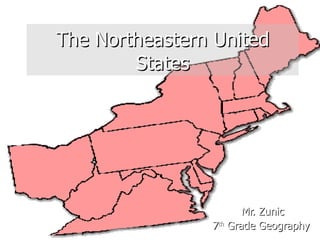
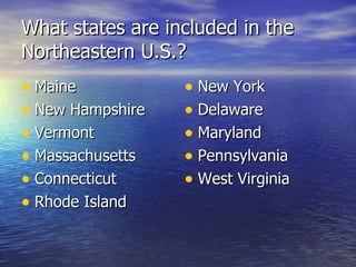
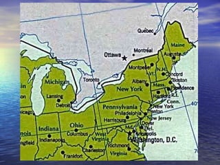
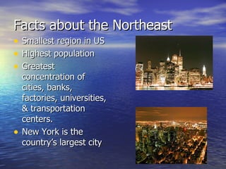
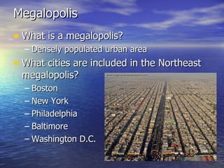
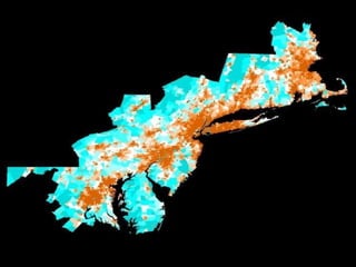
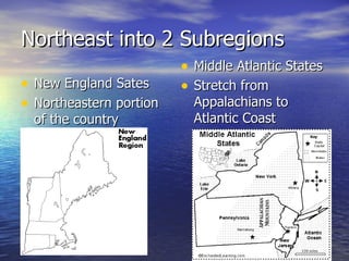
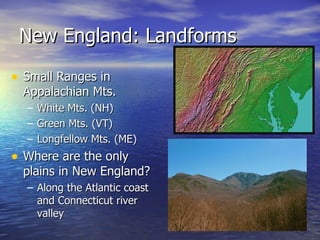
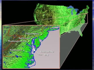
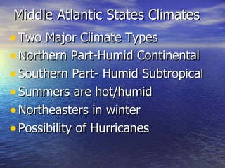
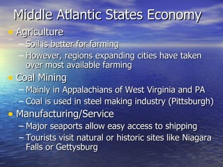
The Northeastern United States Mr. Zunic 7 th  Grade Geography
What states are included in the Northeastern U.S.? Maine New Hampshire  Vermont  Massachusetts  Connecticut  Rhode Island  New York  Delaware  Maryland  Pennsylvania  West Virginia
 
Facts about the Northeast Smallest region in US Highest population  Greatest concentration of cities, banks, factories, universities, & transportation centers. New York is the country’s largest city
Megalopolis What is a megalopolis? Densely populated urban area  What cities are included in the Northeast megalopolis?  Boston New York Philadelphia Baltimore Washington D.C.
 
Except for Washington D.C., how did the rest of these cities start? Founded in colonial times, grew up as important sea ports Major Industrial & Financial Centers
What is Washington D.C? What does D.C. stand for? The United States Capital  D.C.- District of Columbia
 
Northeast into 2 Subregions New England Sates Northeastern portion of the country  Middle Atlantic States Stretch from Appalachians to Atlantic Coast
New England: Landforms Small Ranges in Appalachian Mts. White Mts. (NH) Green Mts. (VT) Longfellow Mts. (ME) Where are the only plains in New England? Along the Atlantic coast and Connecticut river valley
New England: Landforms contd Describe New England’s coastline Northern coast (ME)= rugged/rocky with inlets, bays & peninsulas Southern coast is a Moraine  What is a Moraine? A ridge of rocks piled up by ice sheets Where can one be found? Nantucket & Martha’s Vineyard
New England Physical Features
New England: Climate Humid Continental  Autumn leaves attract tourists  Winter snow makes for great skiing Summer-fog is common along the coast Hurricanes may strike southern New England North Atlantic winter storms called Northeasters
New England: Economy Agriculture  Dairy farming is most important agriculture activity Short growing season & rocky terrain limit farming Other crops include potatoes & cranberries  Fishing  Cool shallow water are good fishing Cod & shellfish are valuable  US govt has rules to prevent over-fishing
New England: Economy Shipbuilding Major industry in colonial New England Builders used wood from the regions forests Nearly all forests are second-growth  Schools/Universities  Yale, Harvard, MIT, UMass, Uconn, etc…
New England Economy
Middle Atlantic States: Landforms Coastal Plain Stretches across all Mid Atlantic States except West Virginia This flat plain does not rise much above sea level Long Island & Chesapeake are part of plain
Middle Atlantic States: Landforms contd What is an estuary? Body of water where salty seawater & freshwater meet Example of an estuary Chesapeake Bay Piedmont Region slopes down from Appalachians to Costal Plain Where these areas meet, rivers plunge over rapids/waterfalls (Water Power)
 
Middle Atlantic States: Landforms contd Appalachian Mountains Northern Part of Appalachians crosses Mid Atlantic Several rivers pass through Mts. Potomac, Susquehanna, Delaware, Hudson
Mid Atlantic Physical Features
Middle Atlantic States Climates  Two Major Climate Types Northern Part-Humid Continental Southern Part- Humid Subtropical  Summers are hot/humid Northeasters in winter  Possibility of Hurricanes
Middle Atlantic States Economy  Agriculture Soil is better for farming However, regions expanding cities have taken over most available farming  Coal Mining  Mainly in Appalachians of West Virginia and PA Coal is used in steel making industry (Pittsburgh) Manufacturing/Service Major seaports allow easy access to shipping Tourists visit natural or historic sites like Niagara Falls or Gettysburg
 
Middle Atlantic Economy

The northeastern united states

  • 1.
    The Northeastern UnitedStates Mr. Zunic 7 th Grade Geography
  • 2.
    What states areincluded in the Northeastern U.S.? Maine New Hampshire Vermont Massachusetts Connecticut Rhode Island New York Delaware Maryland Pennsylvania West Virginia
  • 3.
  • 4.
    Facts about theNortheast Smallest region in US Highest population Greatest concentration of cities, banks, factories, universities, & transportation centers. New York is the country’s largest city
  • 5.
    Megalopolis What isa megalopolis? Densely populated urban area What cities are included in the Northeast megalopolis? Boston New York Philadelphia Baltimore Washington D.C.
  • 6.
  • 7.
    Except for WashingtonD.C., how did the rest of these cities start? Founded in colonial times, grew up as important sea ports Major Industrial & Financial Centers
  • 8.
    What is WashingtonD.C? What does D.C. stand for? The United States Capital D.C.- District of Columbia
  • 9.
  • 10.
    Northeast into 2Subregions New England Sates Northeastern portion of the country Middle Atlantic States Stretch from Appalachians to Atlantic Coast
  • 11.
    New England: LandformsSmall Ranges in Appalachian Mts. White Mts. (NH) Green Mts. (VT) Longfellow Mts. (ME) Where are the only plains in New England? Along the Atlantic coast and Connecticut river valley
  • 12.
    New England: Landformscontd Describe New England’s coastline Northern coast (ME)= rugged/rocky with inlets, bays & peninsulas Southern coast is a Moraine What is a Moraine? A ridge of rocks piled up by ice sheets Where can one be found? Nantucket & Martha’s Vineyard
  • 13.
  • 14.
    New England: ClimateHumid Continental Autumn leaves attract tourists Winter snow makes for great skiing Summer-fog is common along the coast Hurricanes may strike southern New England North Atlantic winter storms called Northeasters
  • 15.
    New England: EconomyAgriculture Dairy farming is most important agriculture activity Short growing season & rocky terrain limit farming Other crops include potatoes & cranberries Fishing Cool shallow water are good fishing Cod & shellfish are valuable US govt has rules to prevent over-fishing
  • 16.
    New England: EconomyShipbuilding Major industry in colonial New England Builders used wood from the regions forests Nearly all forests are second-growth Schools/Universities Yale, Harvard, MIT, UMass, Uconn, etc…
  • 17.
  • 18.
    Middle Atlantic States:Landforms Coastal Plain Stretches across all Mid Atlantic States except West Virginia This flat plain does not rise much above sea level Long Island & Chesapeake are part of plain
  • 19.
    Middle Atlantic States:Landforms contd What is an estuary? Body of water where salty seawater & freshwater meet Example of an estuary Chesapeake Bay Piedmont Region slopes down from Appalachians to Costal Plain Where these areas meet, rivers plunge over rapids/waterfalls (Water Power)
  • 20.
  • 21.
    Middle Atlantic States:Landforms contd Appalachian Mountains Northern Part of Appalachians crosses Mid Atlantic Several rivers pass through Mts. Potomac, Susquehanna, Delaware, Hudson
  • 22.
  • 23.
    Middle Atlantic StatesClimates Two Major Climate Types Northern Part-Humid Continental Southern Part- Humid Subtropical Summers are hot/humid Northeasters in winter Possibility of Hurricanes
  • 24.
    Middle Atlantic StatesEconomy Agriculture Soil is better for farming However, regions expanding cities have taken over most available farming Coal Mining Mainly in Appalachians of West Virginia and PA Coal is used in steel making industry (Pittsburgh) Manufacturing/Service Major seaports allow easy access to shipping Tourists visit natural or historic sites like Niagara Falls or Gettysburg
  • 25.
  • 26.