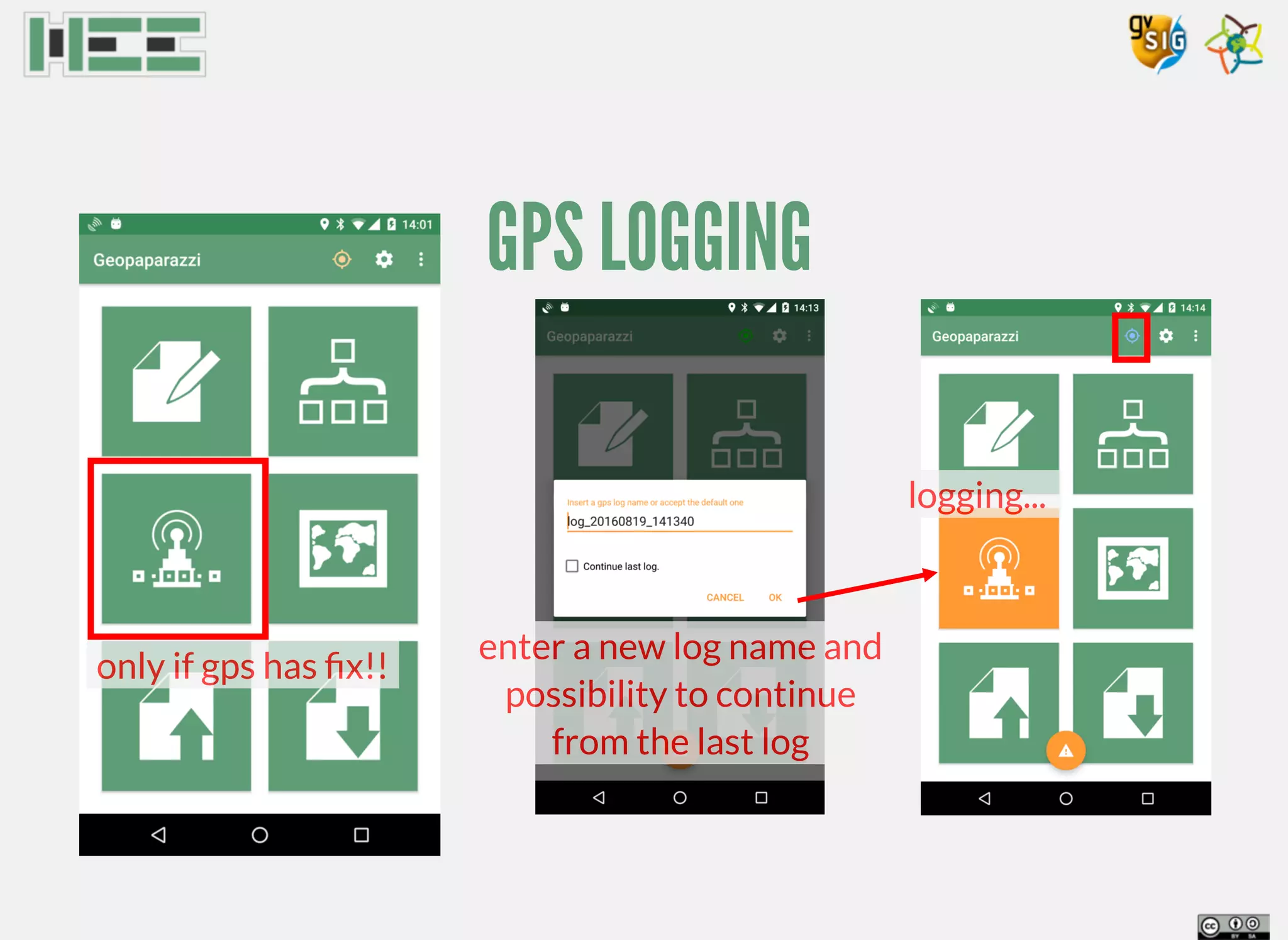
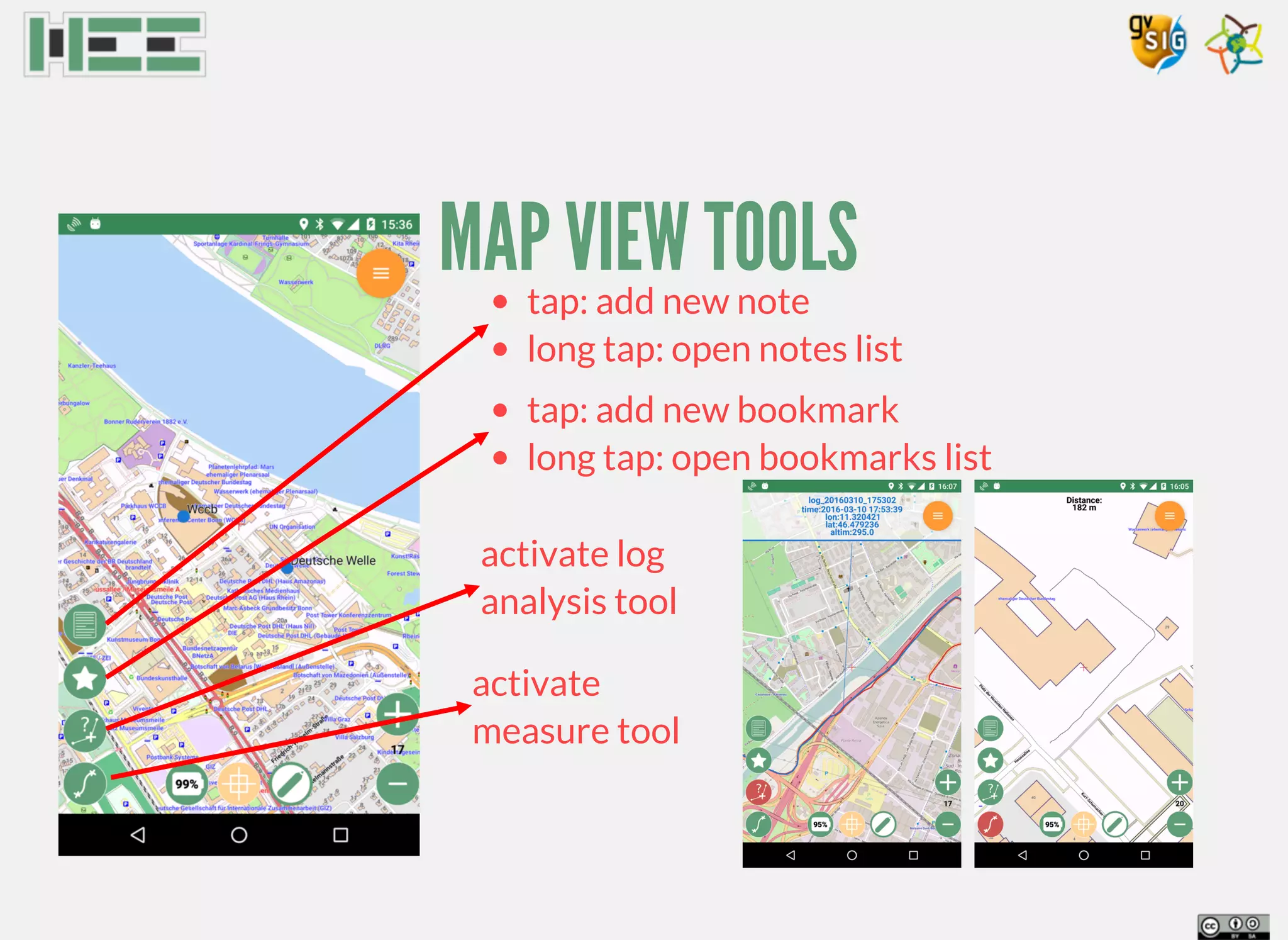
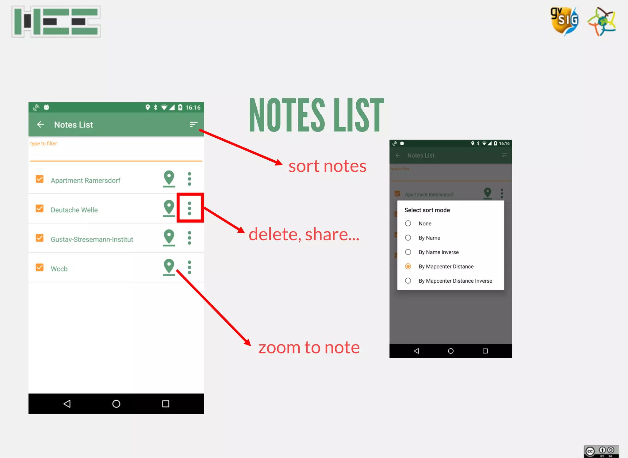
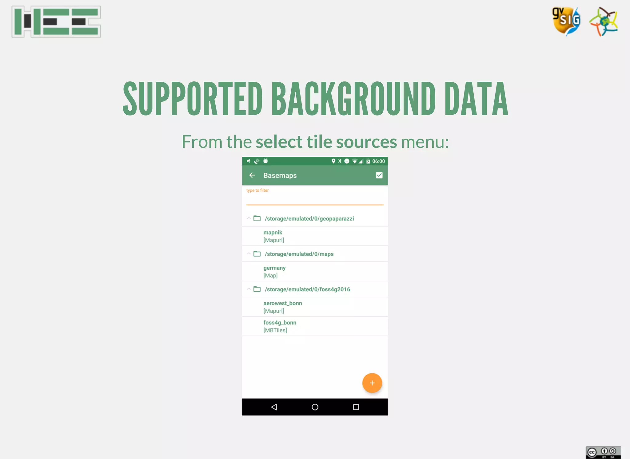
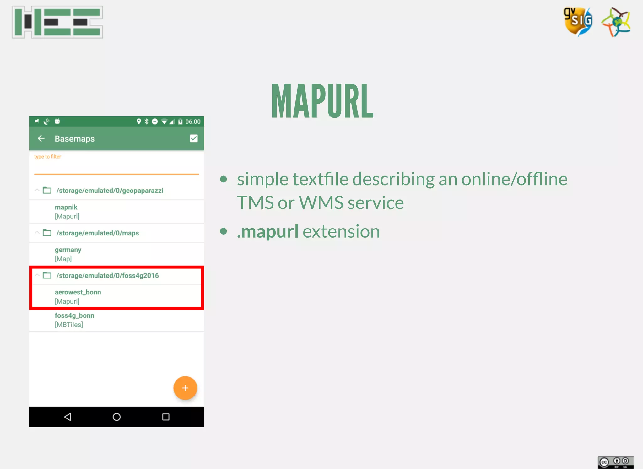
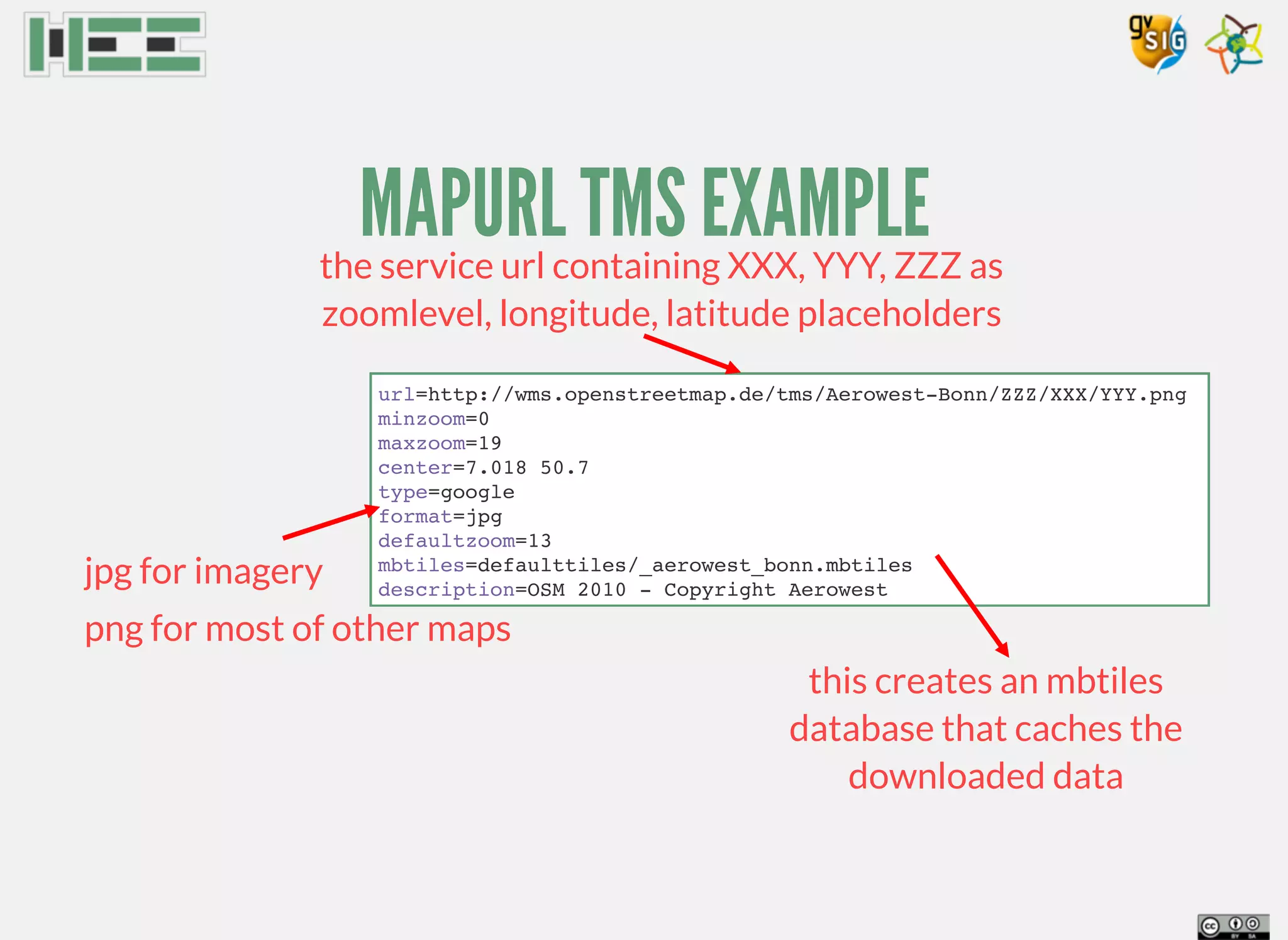
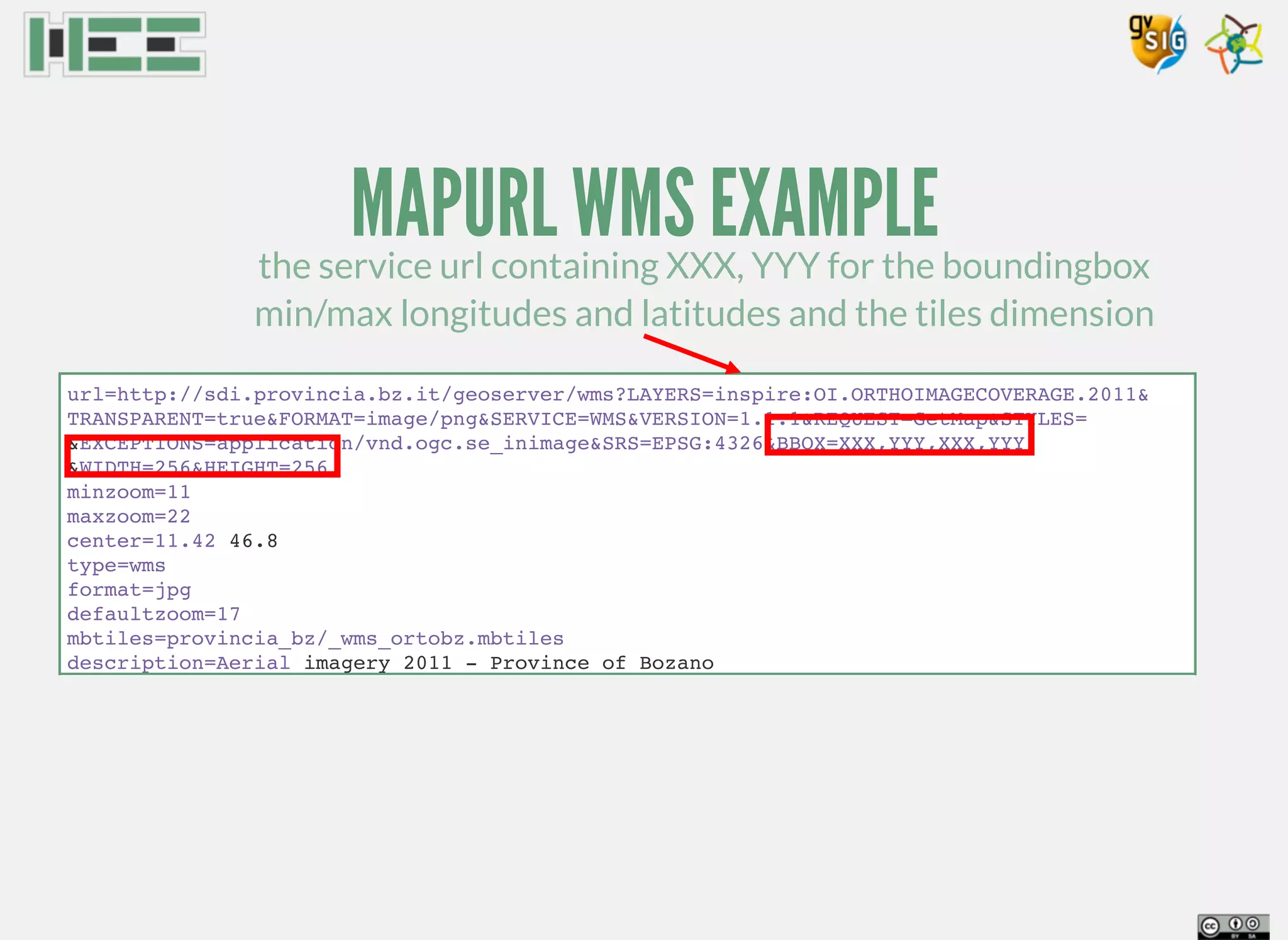
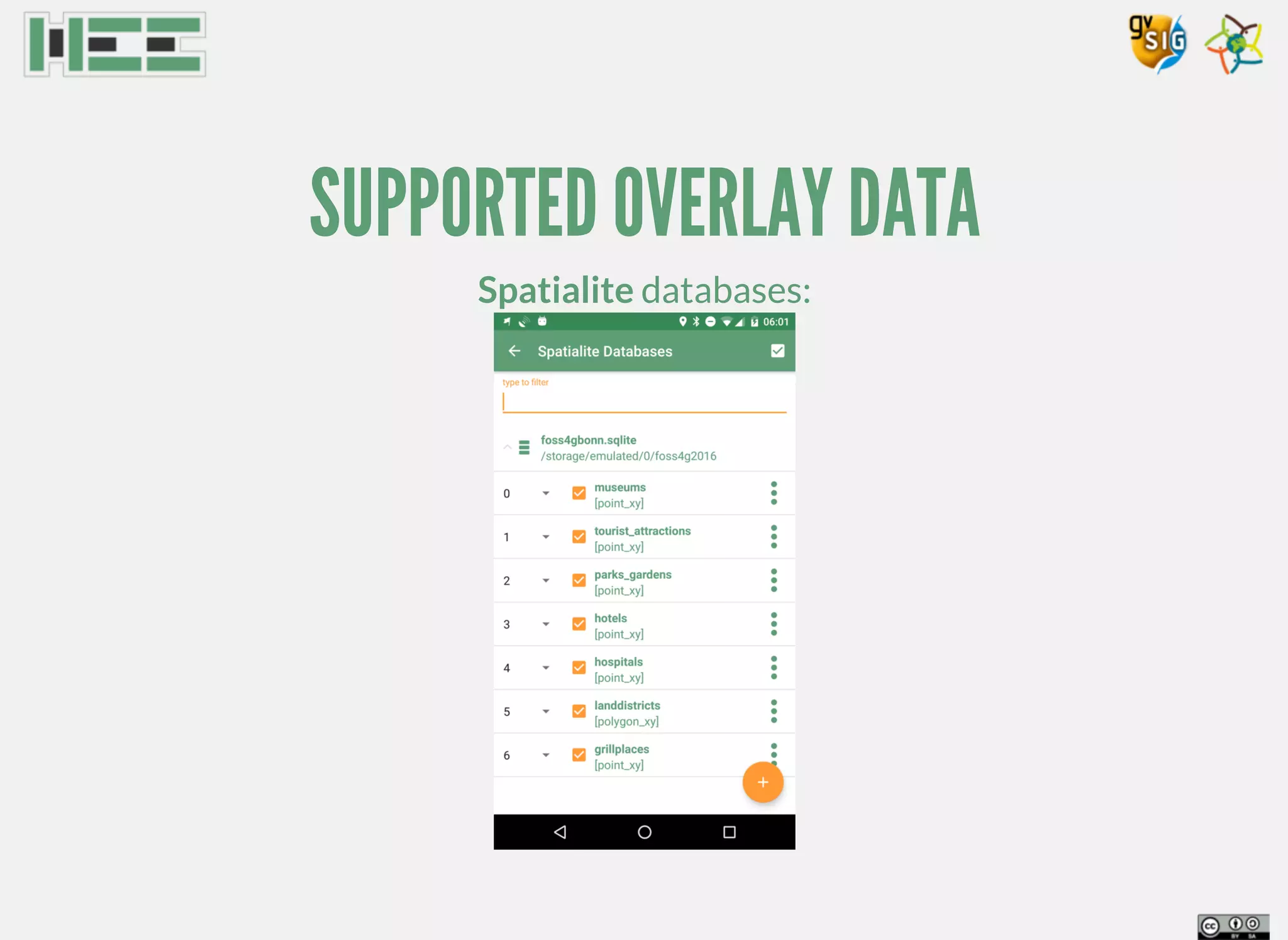
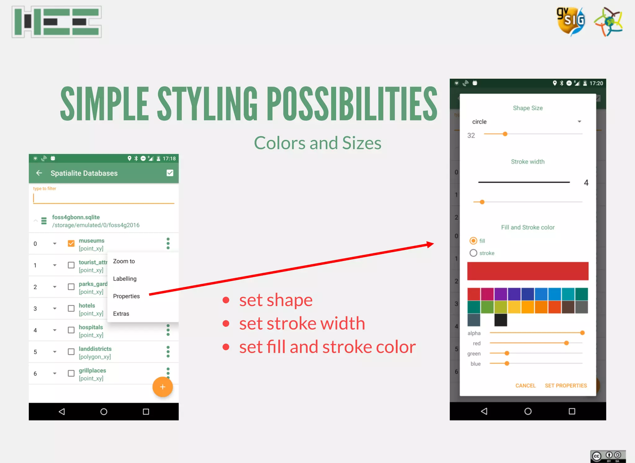
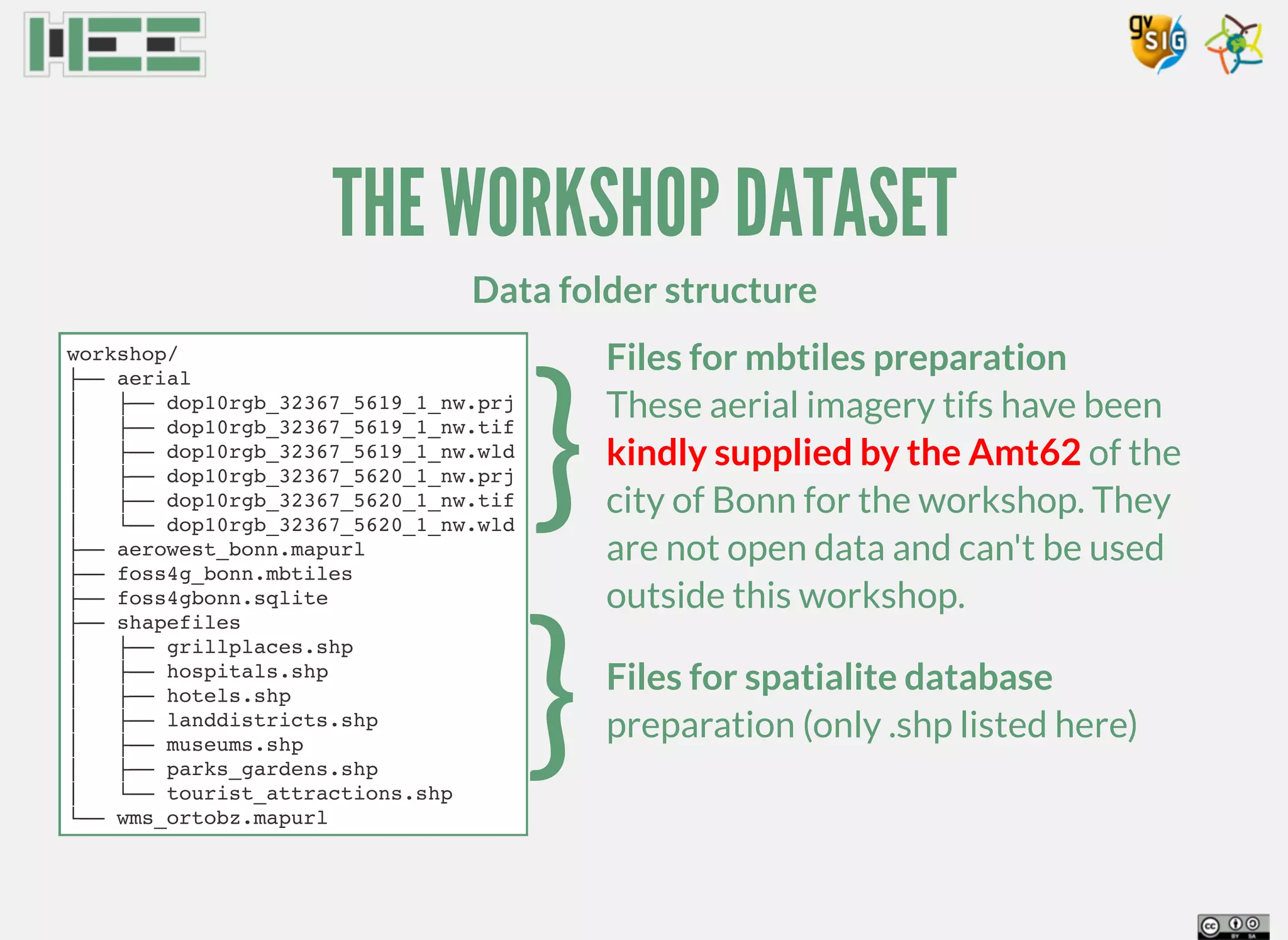
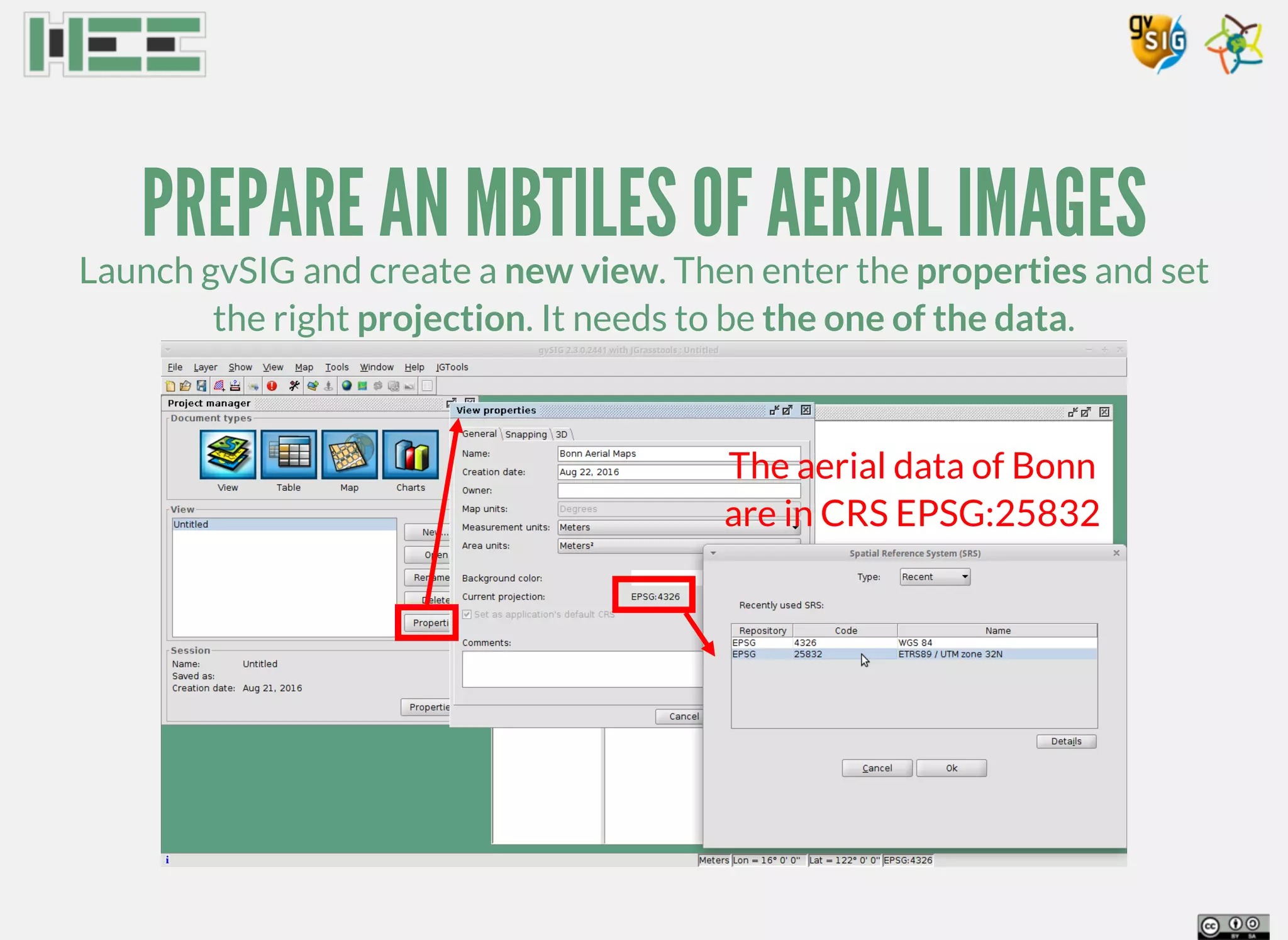
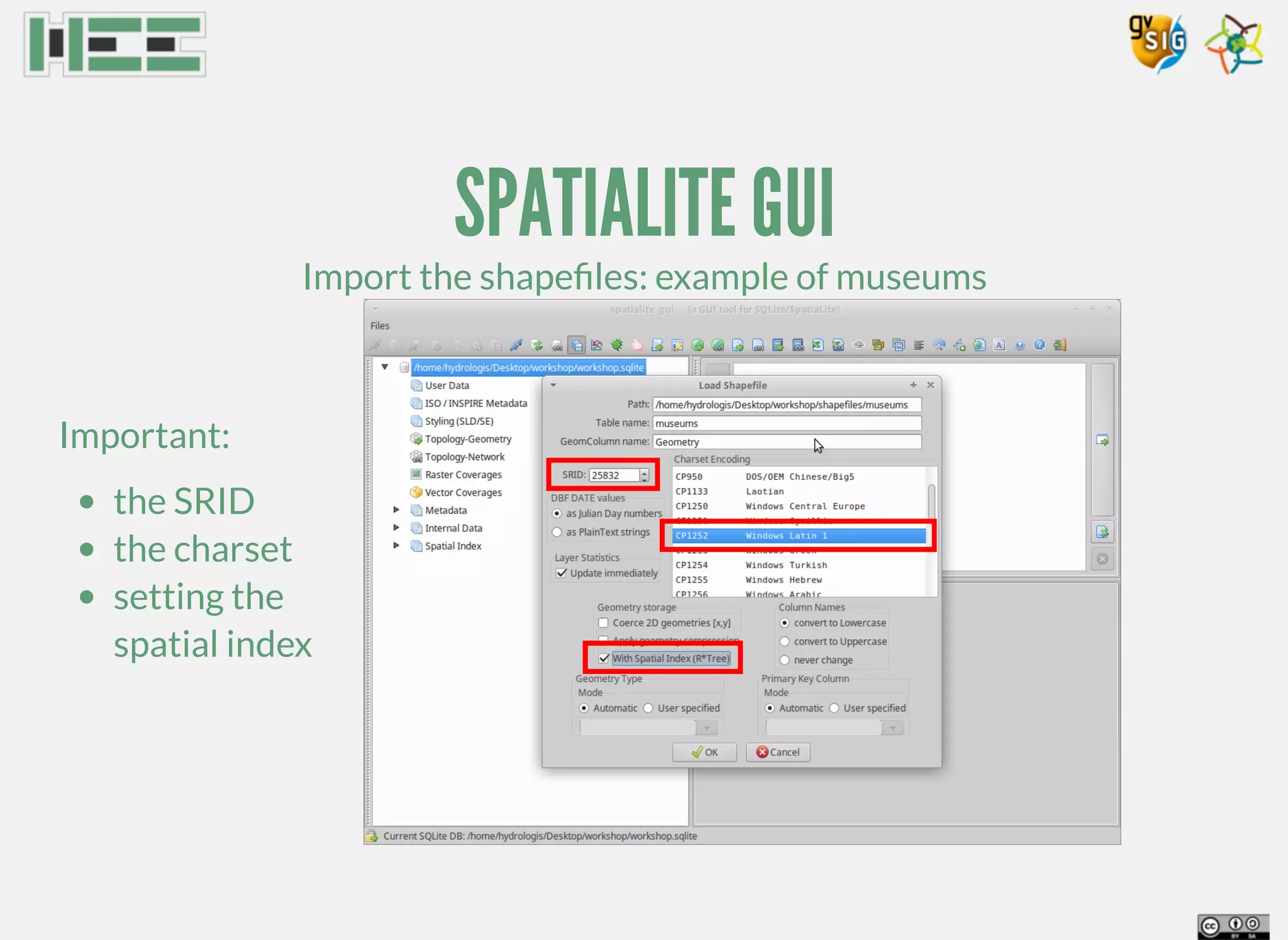
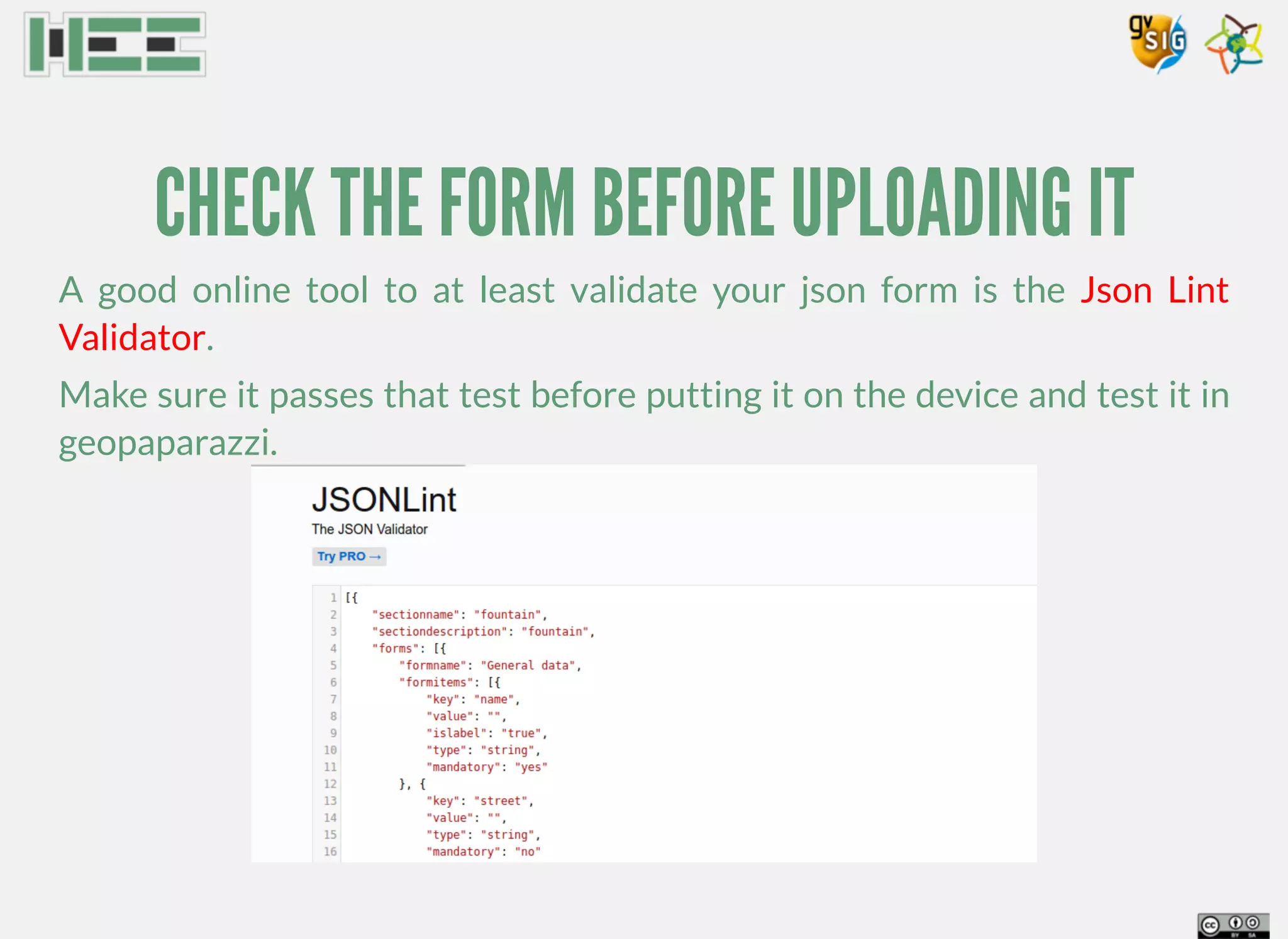
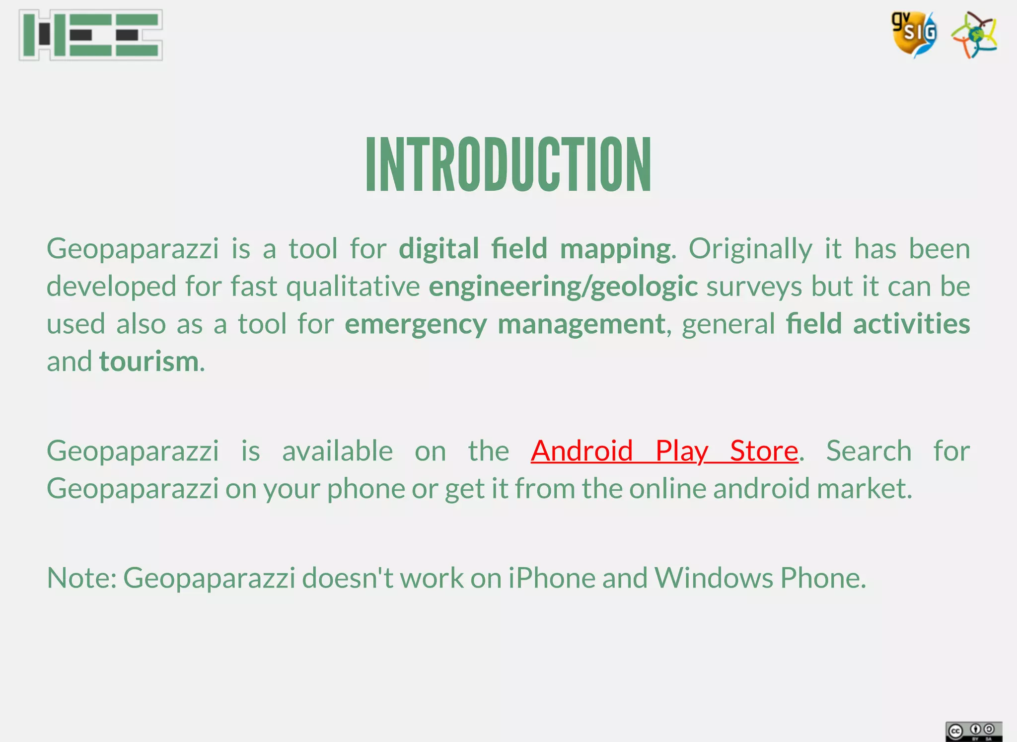
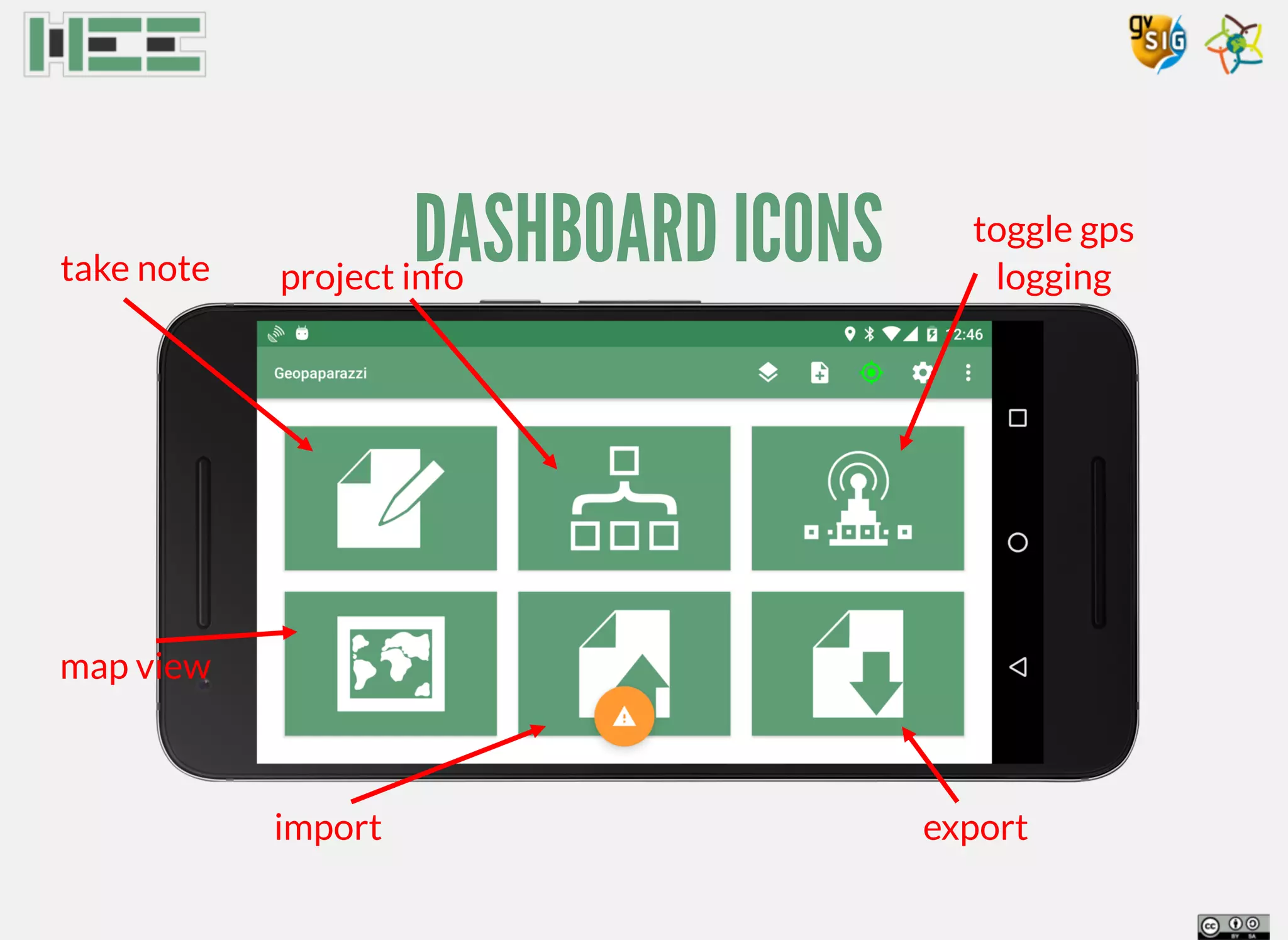
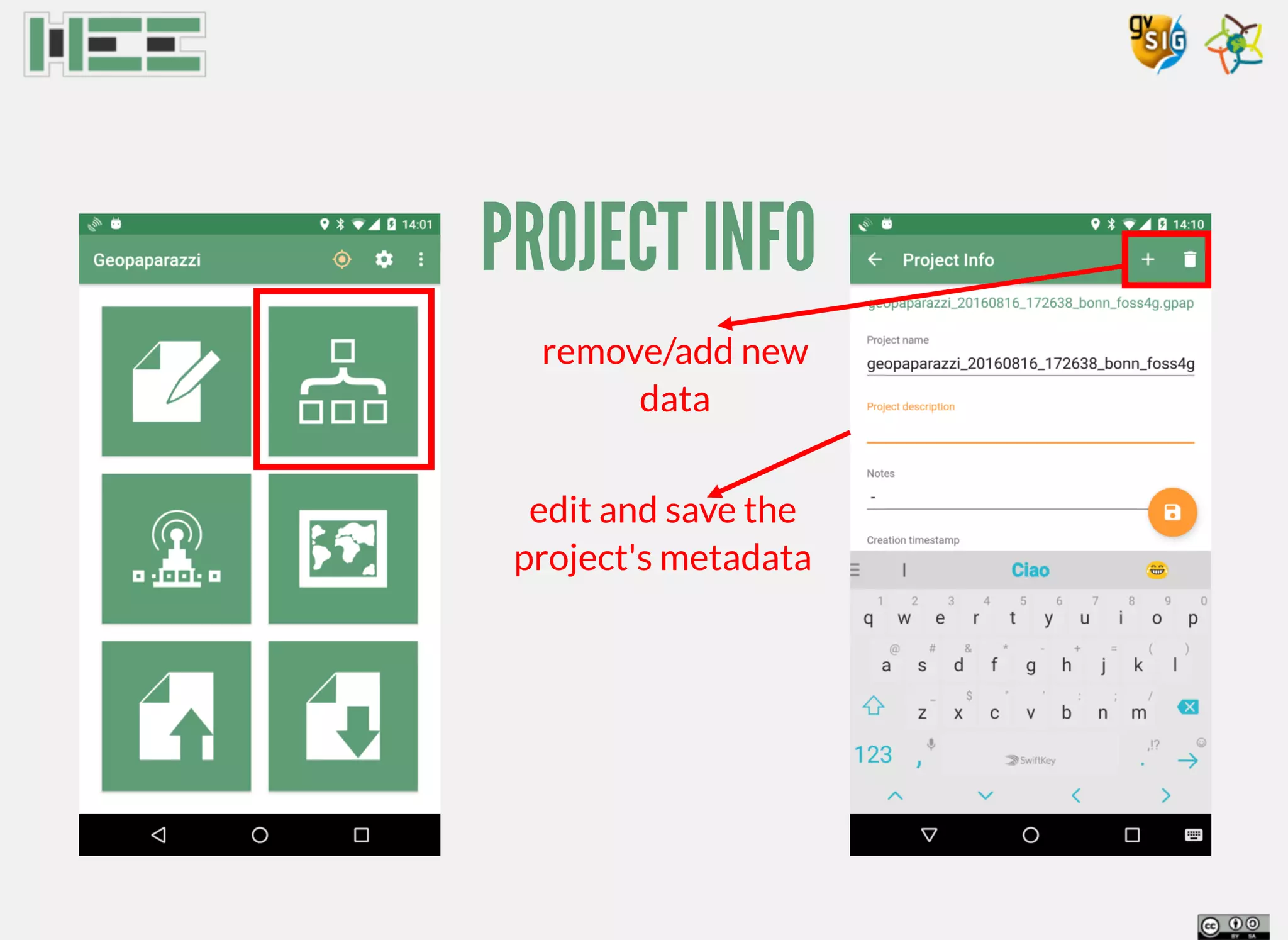
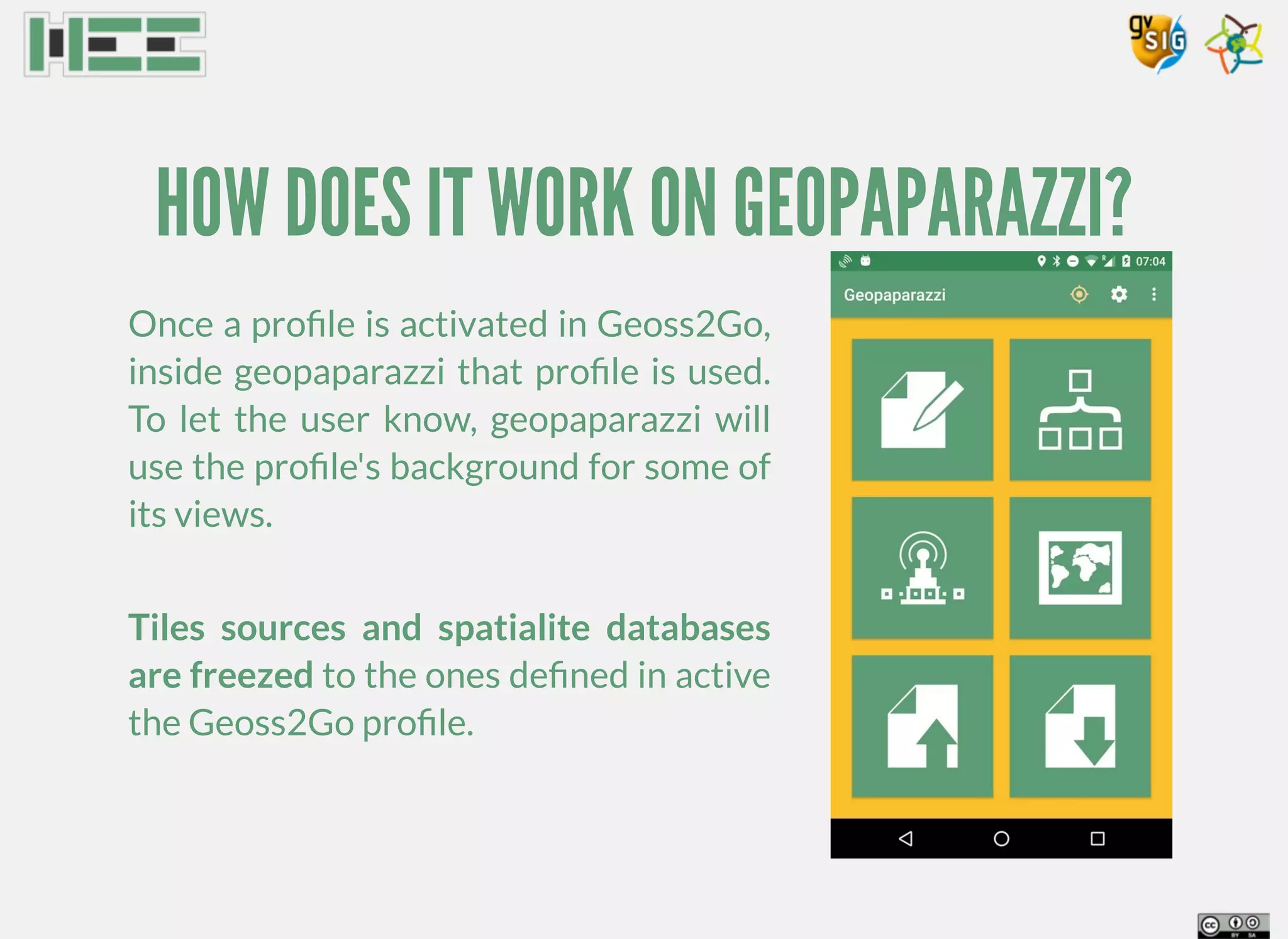
Geopaparazzi is a tool for digital field mapping on Android devices. It allows taking georeferenced notes, photos, and tracking GPS during surveys. The document discusses preparing background map and feature data for use in Geopaparazzi, including creating MBTiles and Spatialite databases. It also covers using the app to conduct a survey, exporting data for analysis in GIS, and developing simple custom survey forms for structured note taking.
Geopaparazzi: Never Out of Data in the Field
The workshop is dedicated to professionals that needs to collect data from the field and use this information to update or create GIS data, but also to OpenStreetMappers as well as tourists that want to keep a geo-diary. Geopaparazzi is a mobile application for digital field mapping for Android devices developed to support the work of the technicians in the field offering a mapping environment with real time GPS position and a form for structured data collection. The application is easy to use, intuitive and provides just few important functionalities to be used in the field, as for example register GPS tracks and take georeferenced notes and pictures with the possibility to work also off line. The main features available in Geopaparazzi are: - taking georeferenced notes: texts, pictures, sketches and forms - logging GPS tracks - browsing and navigation of the maps and the available data - easy export of the collected data - simple preparation of custom background data. The map view shows the GPS position on the reference background data with the possibility to pan and zoom. From the map view it is possible to add and manage notes and bookmarks and measure distances. Notes and bookmarks can be added directly to the map either in the GPS position or in the center of the map. From a dedicated list view it is possible to visualize, zoom and edit each note. Background data can be personalized using available local data or on-line services with the possibility to use vector offline Mapsforge basemaps, Mbtiles offline databases, TMS (online and offline tiles) and WMS services. Geopaparazzi supports personalized complex forms with combo and check boxes, text fields (that can be constrained to number or string type), pictures (taken using the mobile internal camera) and sketches organized over multiple tabs. The workshop starts with an introduction of the application, installation and main features. Then a short section will be dedicated to the preparation of the input data: background maps and vector layers. Following these sections there is a practical testing of Geopaparazzi outdoor in the field. The last section, back in the room, is dedicated to the export of the collected data to be visualized or used in other GIS environments.
Information is more than ever geolocated, but who decides what we see on maps? who curates that information? Maps have never been neutral, but now they are ubiquitous.
This session will be a hands on workshop to enter the maps world and understand how communities can produce and edit their own maps (with openstreetmap.org) and edit and curate information above them (meipi.org).
The workshop will explore ways to integrate critical maps created in other platforms and websites.
Description
Have you ever wanted to make your own map but you didn't know how? Do you want to use your GPS/smart phone? People usually approach maps as inert things, as invariable objects. Now, it's easy to make your own maps and meanwhile understand that maps are not neutral, that Google Maps is not The Map, but just another map. GPS devices and smart phones, DIY aerial cartography (the Public Laboratory), OpenStreetMap map making, are making easier building maps and sharing them. BYO laptop, smartphone or GPS, but if you don't have one, come anyway. Maps can be drawn with a pencil.
Workshop. at AMC. Friday June 29th 2012
Detroit, Michigan. USA
http://amc.alliedmedia.org/
http://talk.alliedmedia.org/amc2012/sessions/google-maps-not-map
geoinformatics handbook:it contains all open source software and commerical software of remote sensing,gis and photogrammerty and also all free data sources.free data sources such as DEM and LIDAR
Comparison of privative and open-source mobile GIS applications.
It includes a feature comparison, perfomance comparison and an anlysis of the open-source projects.
Introduction to geomorphology in GRASS GIS - by Skyler SorsbySkyler Sorsby
GRASS GIS comprises a powerful geographic tool with which to analyze topography and tectonics. Specifically, GIS aids investigation of elevation data and fluvial hydrology. Here is my personal introduction to the creation and manipulation of the data from DEM's in GRASS GIS.
You can find more gis-based geomorphology workflows at my website: https://sites.google.com/site/sorsbysj/
- Skyler Sorsby
Field Data Collecting, Processing and Sharing: Using web Service TechnologiesNiroshan Sanjaya
Collecting, Distributing and Analyzing field data is a crucial part in any geospatial study. Field data collection tools and methods have been developed significantly due to the advancement of technologies such as Global Navigational Satellite Systems (GNSS) and development of smartphones. Accurate field data collection is also a necessary task for broad spatial data analysis and proper decision making. Development of Web technologies led to share the data and information effectively. This study tries to develop a framework based on the Geospatial Semantic Web technologies for disseminating and processing field data. Experimental results from an implemented prototype show that the proposed framework allows to visualize and process the field data in any context. The system of this study is capable of distributing and processing field data using web application. Moreover, the study demonstrates the importance and the capabilities of web services for spatial data gathering and processing. The system has been developed based on Free and Open Source Software (FOSS) packages such as ZOO-Project, Open Data Kit, etc. It enables user to further improve or deploy the system for variety of studies.
Bringing GEOSS services into Practice for Beginners: GeoNode TutorialKudos S.A.S
Bringing GEOSS services into Practice for Beginners: GeoNode Tutorial
Archivo original: ftp://orion.grid.unep.ch/GEOSS_services/geonode/Geonode_tutorial.pdf
gvSIG applications in East Africa:Kenya and SomalilandMaurizio Foderà
GISMAP in Valencia at 9th International gvSIG Conference, with Maurizio Foderà and Antonio Falciano, speaking of consultancies for Cefa - Il seme della solidarietà - Onlus and Terre Solidali.
This is the mago3D technical hands-on material prepared for the FOSS4G Tokyo 2017 attendees. mago3D is the brand-new web based 3D GeoBIM platform on top of Cesium or NASA World Wind. With mago3D, users can service complicated and very large size 3D BIM/AEC data through internet. This material covers what is mago3D, how it works, overall system architecture/components, how to install mago3D, how to convert data and how to get it started. After attending the seminar, users are expected to service their own data through internet using mago3D.
LESTO - a GIS toolbox for LiDAR empowered sciencesAndrea Antonello
My presentation given about the work done at the University of Bolzano on LESTO, the upcoming GIS toolbox for LiDAR based sciences, currently focused on forestry analyses.
Trackoid Rescue - eine mobile Lösung zur Unterstützung von RettungsmannschaftenAndrea Antonello
Presentation given about the Trackoid Rescue Project at the Civil Protect 2013.
Trackoid is built on Geopaparazzi base and is a complete Mobile-Server Application built by HydroloGIS and GIS3W.
Info at: http://rescue.trackoid.eu
Fourth part of the Course "Java Open Source GIS Development - From the building blocks to extending an existing GIS application." held at the University of Potsdam in August 2011
Thrid part of the Course "Java Open Source GIS Development - From the building blocks to extending an existing GIS application." held at the University of Potsdam in August 2011
Dev Dives: Train smarter, not harder – active learning and UiPath LLMs for do...UiPathCommunity
💥 Speed, accuracy, and scaling – discover the superpowers of GenAI in action with UiPath Document Understanding and Communications Mining™:
See how to accelerate model training and optimize model performance with active learning
Learn about the latest enhancements to out-of-the-box document processing – with little to no training required
Get an exclusive demo of the new family of UiPath LLMs – GenAI models specialized for processing different types of documents and messages
This is a hands-on session specifically designed for automation developers and AI enthusiasts seeking to enhance their knowledge in leveraging the latest intelligent document processing capabilities offered by UiPath.
Speakers:
👨🏫 Andras Palfi, Senior Product Manager, UiPath
👩🏫 Lenka Dulovicova, Product Program Manager, UiPath
State of ICS and IoT Cyber Threat Landscape Report 2024 previewPrayukth K V
The IoT and OT threat landscape report has been prepared by the Threat Research Team at Sectrio using data from Sectrio, cyber threat intelligence farming facilities spread across over 85 cities around the world. In addition, Sectrio also runs AI-based advanced threat and payload engagement facilities that serve as sinks to attract and engage sophisticated threat actors, and newer malware including new variants and latent threats that are at an earlier stage of development.
The latest edition of the OT/ICS and IoT security Threat Landscape Report 2024 also covers:
State of global ICS asset and network exposure
Sectoral targets and attacks as well as the cost of ransom
Global APT activity, AI usage, actor and tactic profiles, and implications
Rise in volumes of AI-powered cyberattacks
Major cyber events in 2024
Malware and malicious payload trends
Cyberattack types and targets
Vulnerability exploit attempts on CVEs
Attacks on counties – USA
Expansion of bot farms – how, where, and why
In-depth analysis of the cyber threat landscape across North America, South America, Europe, APAC, and the Middle East
Why are attacks on smart factories rising?
Cyber risk predictions
Axis of attacks – Europe
Systemic attacks in the Middle East
Download the full report from here:
https://sectrio.com/resources/ot-threat-landscape-reports/sectrio-releases-ot-ics-and-iot-security-threat-landscape-report-2024/
Accelerate your Kubernetes clusters with Varnish CachingThijs Feryn
A presentation about the usage and availability of Varnish on Kubernetes. This talk explores the capabilities of Varnish caching and shows how to use the Varnish Helm chart to deploy it to Kubernetes.
This presentation was delivered at K8SUG Singapore. See https://feryn.eu/presentations/accelerate-your-kubernetes-clusters-with-varnish-caching-k8sug-singapore-28-2024 for more details.
Essentials of Automations: Optimizing FME Workflows with ParametersSafe Software
Are you looking to streamline your workflows and boost your projects’ efficiency? Do you find yourself searching for ways to add flexibility and control over your FME workflows? If so, you’re in the right place.
Join us for an insightful dive into the world of FME parameters, a critical element in optimizing workflow efficiency. This webinar marks the beginning of our three-part “Essentials of Automation” series. This first webinar is designed to equip you with the knowledge and skills to utilize parameters effectively: enhancing the flexibility, maintainability, and user control of your FME projects.
Here’s what you’ll gain:
- Essentials of FME Parameters: Understand the pivotal role of parameters, including Reader/Writer, Transformer, User, and FME Flow categories. Discover how they are the key to unlocking automation and optimization within your workflows.
- Practical Applications in FME Form: Delve into key user parameter types including choice, connections, and file URLs. Allow users to control how a workflow runs, making your workflows more reusable. Learn to import values and deliver the best user experience for your workflows while enhancing accuracy.
- Optimization Strategies in FME Flow: Explore the creation and strategic deployment of parameters in FME Flow, including the use of deployment and geometry parameters, to maximize workflow efficiency.
- Pro Tips for Success: Gain insights on parameterizing connections and leveraging new features like Conditional Visibility for clarity and simplicity.
We’ll wrap up with a glimpse into future webinars, followed by a Q&A session to address your specific questions surrounding this topic.
Don’t miss this opportunity to elevate your FME expertise and drive your projects to new heights of efficiency.
GDG Cloud Southlake #33: Boule & Rebala: Effective AppSec in SDLC using Deplo...James Anderson
Effective Application Security in Software Delivery lifecycle using Deployment Firewall and DBOM
The modern software delivery process (or the CI/CD process) includes many tools, distributed teams, open-source code, and cloud platforms. Constant focus on speed to release software to market, along with the traditional slow and manual security checks has caused gaps in continuous security as an important piece in the software supply chain. Today organizations feel more susceptible to external and internal cyber threats due to the vast attack surface in their applications supply chain and the lack of end-to-end governance and risk management.
The software team must secure its software delivery process to avoid vulnerability and security breaches. This needs to be achieved with existing tool chains and without extensive rework of the delivery processes. This talk will present strategies and techniques for providing visibility into the true risk of the existing vulnerabilities, preventing the introduction of security issues in the software, resolving vulnerabilities in production environments quickly, and capturing the deployment bill of materials (DBOM).
Speakers:
Bob Boule
Robert Boule is a technology enthusiast with PASSION for technology and making things work along with a knack for helping others understand how things work. He comes with around 20 years of solution engineering experience in application security, software continuous delivery, and SaaS platforms. He is known for his dynamic presentations in CI/CD and application security integrated in software delivery lifecycle.
Gopinath Rebala
Gopinath Rebala is the CTO of OpsMx, where he has overall responsibility for the machine learning and data processing architectures for Secure Software Delivery. Gopi also has a strong connection with our customers, leading design and architecture for strategic implementations. Gopi is a frequent speaker and well-known leader in continuous delivery and integrating security into software delivery.
Smart TV Buyer Insights Survey 2024 by 91mobiles.pdf91mobiles
91mobiles recently conducted a Smart TV Buyer Insights Survey in which we asked over 3,000 respondents about the TV they own, aspects they look at on a new TV, and their TV buying preferences.
Transcript: Selling digital books in 2024: Insights from industry leaders - T...BookNet Canada
The publishing industry has been selling digital audiobooks and ebooks for over a decade and has found its groove. What’s changed? What has stayed the same? Where do we go from here? Join a group of leading sales peers from across the industry for a conversation about the lessons learned since the popularization of digital books, best practices, digital book supply chain management, and more.
Link to video recording: https://bnctechforum.ca/sessions/selling-digital-books-in-2024-insights-from-industry-leaders/
Presented by BookNet Canada on May 28, 2024, with support from the Department of Canadian Heritage.
Builder.ai Founder Sachin Dev Duggal's Strategic Approach to Create an Innova...Ramesh Iyer
In today's fast-changing business world, Companies that adapt and embrace new ideas often need help to keep up with the competition. However, fostering a culture of innovation takes much work. It takes vision, leadership and willingness to take risks in the right proportion. Sachin Dev Duggal, co-founder of Builder.ai, has perfected the art of this balance, creating a company culture where creativity and growth are nurtured at each stage.
JMeter webinar - integration with InfluxDB and GrafanaRTTS
Watch this recorded webinar about real-time monitoring of application performance. See how to integrate Apache JMeter, the open-source leader in performance testing, with InfluxDB, the open-source time-series database, and Grafana, the open-source analytics and visualization application.
In this webinar, we will review the benefits of leveraging InfluxDB and Grafana when executing load tests and demonstrate how these tools are used to visualize performance metrics.
Length: 30 minutes
Session Overview
-------------------------------------------
During this webinar, we will cover the following topics while demonstrating the integrations of JMeter, InfluxDB and Grafana:
- What out-of-the-box solutions are available for real-time monitoring JMeter tests?
- What are the benefits of integrating InfluxDB and Grafana into the load testing stack?
- Which features are provided by Grafana?
- Demonstration of InfluxDB and Grafana using a practice web application
To view the webinar recording, go to:
https://www.rttsweb.com/jmeter-integration-webinar
LF Energy Webinar: Electrical Grid Modelling and Simulation Through PowSyBl -...DanBrown980551
Do you want to learn how to model and simulate an electrical network from scratch in under an hour?
Then welcome to this PowSyBl workshop, hosted by Rte, the French Transmission System Operator (TSO)!
During the webinar, you will discover the PowSyBl ecosystem as well as handle and study an electrical network through an interactive Python notebook.
PowSyBl is an open source project hosted by LF Energy, which offers a comprehensive set of features for electrical grid modelling and simulation. Among other advanced features, PowSyBl provides:
- A fully editable and extendable library for grid component modelling;
- Visualization tools to display your network;
- Grid simulation tools, such as power flows, security analyses (with or without remedial actions) and sensitivity analyses;
The framework is mostly written in Java, with a Python binding so that Python developers can access PowSyBl functionalities as well.
What you will learn during the webinar:
- For beginners: discover PowSyBl's functionalities through a quick general presentation and the notebook, without needing any expert coding skills;
- For advanced developers: master the skills to efficiently apply PowSyBl functionalities to your real-world scenarios.
Epistemic Interaction - tuning interfaces to provide information for AI supportAlan Dix
Paper presented at SYNERGY workshop at AVI 2024, Genoa, Italy. 3rd June 2024
https://alandix.com/academic/papers/synergy2024-epistemic/
As machine learning integrates deeper into human-computer interactions, the concept of epistemic interaction emerges, aiming to refine these interactions to enhance system adaptability. This approach encourages minor, intentional adjustments in user behaviour to enrich the data available for system learning. This paper introduces epistemic interaction within the context of human-system communication, illustrating how deliberate interaction design can improve system understanding and adaptation. Through concrete examples, we demonstrate the potential of epistemic interaction to significantly advance human-computer interaction by leveraging intuitive human communication strategies to inform system design and functionality, offering a novel pathway for enriching user-system engagements.
UiPath Test Automation using UiPath Test Suite series, part 4DianaGray10
Welcome to UiPath Test Automation using UiPath Test Suite series part 4. In this session, we will cover Test Manager overview along with SAP heatmap.
The UiPath Test Manager overview with SAP heatmap webinar offers a concise yet comprehensive exploration of the role of a Test Manager within SAP environments, coupled with the utilization of heatmaps for effective testing strategies.
Participants will gain insights into the responsibilities, challenges, and best practices associated with test management in SAP projects. Additionally, the webinar delves into the significance of heatmaps as a visual aid for identifying testing priorities, areas of risk, and resource allocation within SAP landscapes. Through this session, attendees can expect to enhance their understanding of test management principles while learning practical approaches to optimize testing processes in SAP environments using heatmap visualization techniques
What will you get from this session?
1. Insights into SAP testing best practices
2. Heatmap utilization for testing
3. Optimization of testing processes
4. Demo
Topics covered:
Execution from the test manager
Orchestrator execution result
Defect reporting
SAP heatmap example with demo
Speaker:
Deepak Rai, Automation Practice Lead, Boundaryless Group and UiPath MVP
Generating a custom Ruby SDK for your web service or Rails API using Smithyg2nightmarescribd
Have you ever wanted a Ruby client API to communicate with your web service? Smithy is a protocol-agnostic language for defining services and SDKs. Smithy Ruby is an implementation of Smithy that generates a Ruby SDK using a Smithy model. In this talk, we will explore Smithy and Smithy Ruby to learn how to generate custom feature-rich SDKs that can communicate with any web service, such as a Rails JSON API.
3. INTRODUCTION
Geopaparazzi is a tool for digital field mapping. Originally it has been
developed for fast qualitative engineering/geologic surveys but it can be
used also as a tool for emergency management, general field activities
and tourism.
Geopaparazzi is available on the . Search for
Geopaparazzi on your phone or get it from the online android market.
Note: Geopaparazzi doesn't work on iPhone and Windows Phone.
Android Play Store
4. INTRODUCTION
The main aim of Geopaparazzi is to have a tool that:
can be always at hand when needed
gives the possibility to take georeferenced pictures during the survey,
with further possibility to import them into a main GIS application
is extremely easy to use and intuitive, providing just few important
functionalities
5. INTRODUCTION
The main features available in Geopaparazzi are:
georeferenced notes: text notes, pictures, sketches, forms
gps tracks logging
a map view for browsing and navigation of the data
easy export of collected data
simple generation of any type of background map
6. INSTALLATION
1. connect your Android device to internet
2. open Play Store
3. type geopaparazzi within the Search textbox
7. INSTALLATION
1. connect your Android device to internet
2. open Play Store
3. type geopaparazzi within the Search textbox
4. select to install the first application found
with the right name: geopaparazzi (not
geopaparazzi3)
15. MAP VIEW TOOLStap: add new note
long tap: open notes list
tap: add new bookmark
long tap: open bookmarks list
activate log
analysis tool
activate
measure tool
18. IMPORT
browse/import
projects from the net
import csv files that start
with bookmarks_xyz.csv
and contain lines of the
form: label,lat,lon,zoom
create a simple
spatialite database
with a point, line and
polygon table
voluntary online
service that
supplies mapurls
19. EXPORT
only export that
supports proper
complex notes
representation
export all the
images of the
project into a folder
upload the
current project
to the net
21. MAPSFORGE
open source project under LGPL
license
.map extension
binary vector format
maps available for download at:
http://download.mapsforge.org/maps/
22. MBTILES
open specifications:
.map extension
image tiles format
can be created in many different ways (ex.
jgrasstools, gvSIG, gdal)
https://github.com/mapbox/mbtiles-spec
Mapbox presentation page
32. THE WORKSHOP DATASET
Data folder structure
workshop/
├── aerial
│ ├── dop10rgb_32367_5619_1_nw.prj
│ ├── dop10rgb_32367_5619_1_nw.tif
│ ├── dop10rgb_32367_5619_1_nw.wld
│ ├── dop10rgb_32367_5620_1_nw.prj
│ ├── dop10rgb_32367_5620_1_nw.tif
│ └── dop10rgb_32367_5620_1_nw.wld
├── aerowest_bonn.mapurl
├── foss4g_bonn.mbtiles
├── foss4gbonn.sqlite
├── shapefiles
│ ├── grillplaces.shp
│ ├── hospitals.shp
│ ├── hotels.shp
│ ├── landdistricts.shp
│ ├── museums.shp
│ ├── parks_gardens.shp
│ └── tourist_attractions.shp
└── wms_ortobz.mapurl
}
}
Files for mbtiles preparation
Files for spatialite database
preparation (only .shp listed here)
These aerial imagery tifs have been
kindly supplied by the Amt62 of the
city of Bonn for the workshop. They
are not open data and can't be used
outside this workshop.
33. PREPARE AN MBTILES OF AERIAL IMAGES
Launch gvSIG and create a new view. Then enter the properties and set
the right projection. It needs to be the one of the data.
The aerial data of Bonn
are in CRS EPSG:25832
34. PREPARE AN MBTILES OF AERIAL IMAGES
Drag the aerial images (*.tif) into the map view.
select "non tiled"
when asked
35. PREPARE AN MBTILES OF AERIAL IMAGES
Now open the integrated tiles creator
insert the requested parameters
and push the ok button
36. PREPARE AN MBTILES OF AERIAL IMAGES
Be careful what you wish for!
The supplied dataset covers an area that at zoomlevel 19 counts 1892
tiles and it grows exponentially! So careful with the max zoomlevel.
43. LOAD THE DATA ON THE DEVICE
When connecting via USB-cable, we experiences many times database
corruptions, so we started using the app: Airdroid
type the url in the browser (inside the same
network) and you will be able to see your phone
and upload/download data
48. VIEW GEOPAPARAZZI PROJECTS
The user should put all the projects in a a folder and select that. There is
also the possibility to create an empty folder and enter in server mode.
enter in server
mode and supply
a network port
browser for the
projects folder
49. VIEW GEOPAPARAZZI PROJECTS
Now we need to configure geopaparazzi to connect to the server.
On the pc find its network address.
50. VIEW GEOPAPARAZZI PROJECTS
In geopaparazzi set the server's address.
To do so go in Settings->STAGE sync settings-> Server to connect to
the format is:
ipaddress:port
where port is the
one set in gvSIG
51. VIEW GEOPAPARAZZI PROJECTS
Now enter the export menu and select S.T.A.G.E.
The upload of the current opened project will start.
52. VIEW GEOPAPARAZZI PROJECTS
Once the upload has finished, hit the refresh button and the project will
appear in the projects view. To see what it contains, double click on it.
54. VIEW GEOPAPARAZZI PROJECTS
To load the data of a project, right click on it and push load project.
click to select and zoom to
right click to open or save image
57. CONVERT A PROJECT TO GIS DATA
In gvSIG do an add layer, it will present you Geopaparazzi as an option
browser for a
*.gpap project file
58. CONVERT A PROJECT TO GIS DATA
When loading a project, the metadata of the project are checked and a list
of available data is presented.
the layers that will be created
on import are listed here
project metadata
if this is not checked, memory layers
are created (not recomended)
59. CONVERT A PROJECT TO GIS DATA
The new layers of gps logs, notes and media are created containing most
possible information in the attributes table
the shapefiles are
created in a folder
beside the project file
60. CONVERT A PROJECT TO GIS DATA
To open images from the notes, a small tool is supplied
it enables a selection tool
that selects only notes
from the media layer
61. CONVERT A PROJECT TO GIS DATA
On selection the connected image (found in the media folder) is opened
with the default operating system application
63. WHAT IS GEOSS2GO
Geoss2Go is powerful tool for professionals to better organize
their work. It can also be used to keep data organized in
categories, by nation, by project, by whatever necessary.
Together with Geopaparazzi it gives the possibility to standardize
the layout of surveys for teams in a simple and effective way.
Installing datasets and survey forms has never been that simple.
This app has been funded by the MYGEOSS call for innovative
apps of the European Commission.
64. INSTALL AND OPEN GEOSS2GO
Geoss2Go can be found and installed from the .
Once it is launched, it presents the following view:
Google Play store
65. WORKING WITH PROFILES
To create a new profile we can simply push
the red button on the upper right part of
the view.
Once pushed, the main profile info dialog
will pop-up. There the user can insert a
profile name and some description about
the profile.
66. WORKING WITH PROFILES
Once ok is pushed, the profile
is created. It contains
information about the
contained datasets and forms.
Delete the profile
67. WORKING WITH PROFILES
Styling the profile can be
handy, but will also have an
important impact on its view
in geopaparazzi.
69. WHAT CAN YOU ADD?
Basemap types supported Spatialite databases
Forms
A project database
70. HOW DOES IT WORK ON GEOPAPARAZZI?
Once a profile is activated in Geoss2Go,
inside geopaparazzi that profile is used.
To let the user know, geopaparazzi will
use the profile's background for some of
its views.
Tiles sources and spatialite databases
are freezed to the ones defined in active
the Geoss2Go profile.
72. WRITING A FORM
Geopaparazzi supports complex notes called form based notes.
To use them, a tags.json file needs to be created and placed inside
the geopaparazzi folder inside the sdcard. In that file a json
format description of the wanted tags and forms needs to be
placed.
By default, to help the user to start, a sample tags.json is created
in the Geopaparazzi installation. It contains form samples and
examples to show all supported form widgets.
73. WRITING A FORM: SECTION=BUTTON
Every form is composed of sections, each of which
creates a button in the add notes view.
[
{
"sectionname": "fountain",
"sectiondescription": "fountain",
"forms": [
]
}
]
74. WRITING A FORM: SUBSECTION=TAB
Each section can contain several sub-forms, that
will create a tab each.
{
"formname": "General data",
"formitems": [
]
},{
"formname": "Technical data",
"formitems": [
]
}
75. WRITING A FORM: FORM ELEMENTS
To add content to the sub-forms, any of the tags described in the
can be used.
For example lets add two textfields to prompt the user for a name and
street. Also the name should then be the label rendered in the map view.
supported tags section
{
"key": "name",
"value": "",
"islabel": "true",
"type": "string",
"mandatory": "yes"
},
{
"key": "street",
"value": "",
"type": "string",
"mandatory": "no"
}
76. WRITING A FORM: MORE FORM ELEMENTS
What about adding a combobox?
{
"key": "type",
"values": {
"items": [
{
"item": ""
},
{
"item": "manual"
},
{
"item": "electrical"
},
{
"item": "gravity"
}
]
},
"value": "manual",
"type": "stringcombo",
"mandatory": "no"
}
77. WRITING A FORM: MORE FORM ELEMENTS
What about adding pictures?
{
"formname": "Media",
"formitems": [
{
"key": "Images",
"value": "",
"type": "pictures",
"mandatory": "no"
}
]
}
78. CHECK THE FORM BEFORE UPLOADING IT
A good online tool to at least validate your json form is the
.
Make sure it passes that test before putting it on the device and test it in
geopaparazzi.
Json Lint
Validator