Download to read offline
![IJRET: International Journal of Research in Engineering and Technology eISSN: 2319-1163 | pISSN: 2321-7308
__________________________________________________________________________________________
IC-RICE Conference Issue | Nov-2013, Available @ http://www.ijret.org 302
FOREST TYPE MAPPING OF BIDAR FOREST DIVISION, KARNATAKA
USING GEOINFORMATICS TECHNIQUES
Shashikant.R.Mise1
, Ganesh2
1
Professor, Department of Civil Engineering, 2
M.Tech Scholar, Department of Environmental Engineering,
PDA College of Engineering, Gulbarga
srmise45@yahoo.com, ganeshn870@gmail.com
Abstract
The study demonstrate the potentiality of satellite remote sensing technique for the generation of baseline information on forest types
including tree plantation details in Bidar forest division, Karnataka covering an area of 5814.60Sq.Kms. The Total Area of Bidar
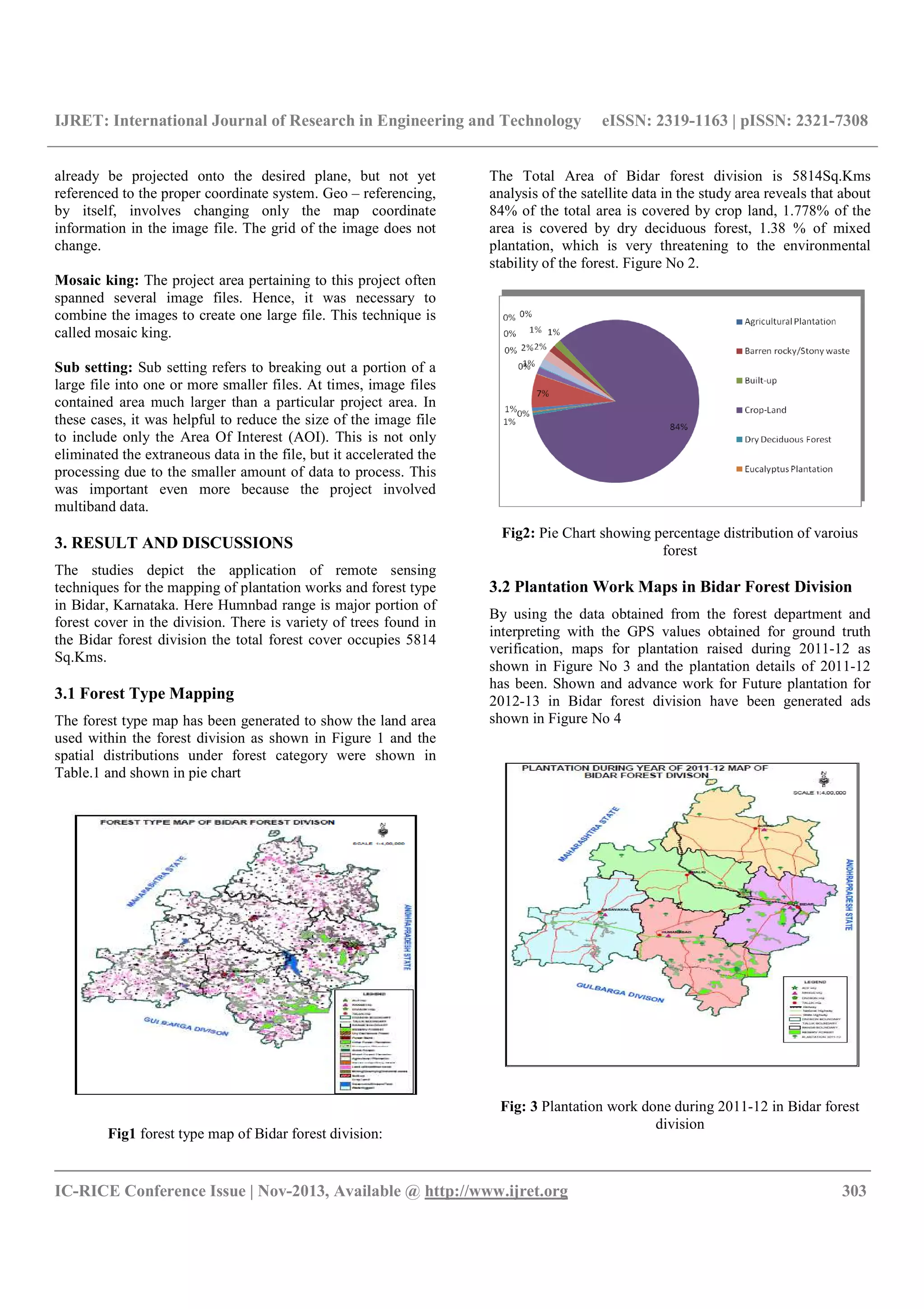
forest division is 5814Sq.Kms analysis of the satellite data in the study area reveals that about 84% of the total area is Covered by
crop land, 1.778% of the area is covered by dry deciduous forest, 1.38 % of mixed plantation, which is very threatening to the
environmental stability of the forest, future plantation site has been mapped. With the use of latest Geo-informatics technology proper
and exact condition of the trees can be observed and necessary precautions can be taken for future plantation works in an appropriate
manner
Keywords:-RS, GIS, GPS, Forest Type, Tree Plantation
---------------------------------------------------------------------***----------------------------------------------------------------------
1. INTRODUCTION
Forest is one of the most magnificent expressions of nature on
earth .It is an important renewable natural resource and
benefits from it are immense, mainly timber and non-timber
forest products. It has been an important source of subsistence,
employment, revenue and raw materials to various industries.
Forest plays an important role in the issues related to green
house gases and climate change which are strongly linked to
the maintenance of ecological balance, biological diversity,
environmental stability, soil and water conservation etc
The main objectives of mapping of the existing forest type and
plantation works carried out in Bidar forest division, arnataka.
To prepare various forest type map in Bidar forest division
using PAN+LISS III data.
Archana et al, (Jan. 2013) had carried out there research
work on “Forest Resource Mapping In Pinjore Block,
Haryana, Using Geoinformatics Techniques” and said that
Forests resources,The analysis of the satellite data also reveals
that an area of 18.33 sq km (6.36%) of TOF were present in
Pinjore block [1]
.
M. Kardos(2013) had carried out his research work on
“Method Of Digital Photogrammetry in forest management in
Slovakia” and said that The practical aspect of utilization of
digital photogrammetry methods and their products in Slovak
forestry is presented. We deal with the comparison of various
data obtained by digital cameras, their accuracy, utilization
and effectiveness for mapping [2]
Muhammad Asim Rizwan (Dec,2011) had carried his
research work on “Forest Mapping by using RS and GIS
Techniques” and said that forest have important and vital
global ecological as well as socio-economic resources and
they require a sustainable management. The aim of this study
has, to map the existing forest, to identify unutilized land, to
develop a plan to increase the existing forest coverage and
carry out the related analysis. [3]
1.1 Scope of the Study:
The scope of interest in this present study is to use the GIS
technologies for the forest management of Bidar division,
Karnataka. As the GIS facility was available locally it was
convenient to carry out the project work. The interest to
choose this particular topic is due to the reason that as per the
collected literature so, far the present study is not carried out
on forest management in Bidar division using RS and GIS
technologies.
2. METHODOLOGY
The following methodology has been adopted for the current
study and shown in Figure1
Image Processing: Initially the satellite imageries mentioned
in the figure above were subjected to radiometric and geo-
metric corrections to get a clear image in real world co-
ordinates.
Geo – referencing: Geo – referencing refers to the process of
assigning map coordinates to image data. The image data may](https://image.slidesharecdn.com/foresttypemappingofbidarforestdivisionkarnataka-140808015649-phpapp01/75/Forest-type-mapping-of-bidar-forest-division-karnataka-1-2048.jpg)
![IJRET: International Journal of Research in Engineering and Technology eISSN: 2319-1163 | pISSN: 2321-7308
__________________________________________________________________________________________
IC-RICE Conference Issue | Nov-2013, Available @ http://www.ijret.org 304
Fig.4 Advance work for future plantation for 2012-13 in Bidar
forest division
3.3 Plantation Works
Tree planting is the process of transplanting tree seeding,
generally for forestry, land reclamination or landscaping
purpose. Tree plantation is helpful in creating instant forest,
tall tree plantation seeding is good for the environment, stop
the encroachment of deserts reclaim land, capture carbon &
reduce-pollution.
CONCLUSIONS
Based on the results obtained the following conclusions have
been made, it is observed that the high resolution LISS-III of
IRS-P5 and PAN are merged in identification of types of
forest & its condition in the study area. The total forest cover
in Bidar forest division is less than 6.67% of the total
geographical area in the study area which is a serious issue to
be considered in order to maintain the environmental stability.
During the ground truth collection
Around 12 Sq.Kms area of the total forest division has been
planted in the year 2011-2012, major plantation work has
been done Humnbad range with plantation covering 8.38
Sq.Kms and least plantation in Aurad range with plantation
covering 0.2665 Sq.Kms and around 9.035 Sq.Kms of land
has been prepared in advance for future plantation in Bidar
forest division. With the use of latest Geo-informatics
technology proper and exact condition of the trees can be
observed and necessary precautions can be taken for future
plantation works in an appropriate manner.
REFERENCES
[1] Archana, Girish Pajar and Mathi Kumar, K.E. (2013)
Forest Resource Mapping In Pinjore Block(Panchkula
District),Haryana, Using Geoinfornatics Techniques,
International Journal of Advanced Technology and
Engineering Research(IJATER) Volume 3,Issue1,Issn
No:2250-3536.
[2] M.Kordas: Method Of Digital Photogrammetry In
Forest Management Of Slovakia, journal Of Forest
Science (2013),59,2013(2):pp54-63.
[3] Mohd Asim Rizwan:Forest. (2011) Mapping Using RS
and GIS Techniques, Global Journals Inc (USA),
Issue7, Version1.0.](https://image.slidesharecdn.com/foresttypemappingofbidarforestdivisionkarnataka-140808015649-phpapp01/75/Forest-type-mapping-of-bidar-forest-division-karnataka-3-2048.jpg)

The document summarizes a study that mapped forest types and plantation works in Bidar Forest Division, Karnataka, India using remote sensing and GIS techniques. Satellite imagery was analyzed which revealed that 84% of the area is covered by crop land, 1.778% by dry deciduous forest, and 1.38% by mixed plantation. Maps were generated showing forest type distribution and plantation works during 2011-2012 and planned for 2012-2013. Around 12 square kilometers were planted in 2011-2012, with most in Humnbad range and least in Aurad range. Proper forest management can be achieved using geoinformatics technologies.


![Seller Deck - Presentation [Concert L2].PPTX](https://cdn.slidesharecdn.com/ss_thumbnails/sellerdeck-presentationconcertl2-251219171156-24982daf-thumbnail.jpg?width=640&height=640&fit=bounds)


