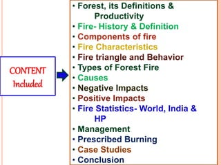
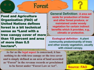
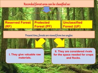
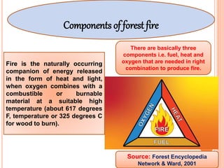
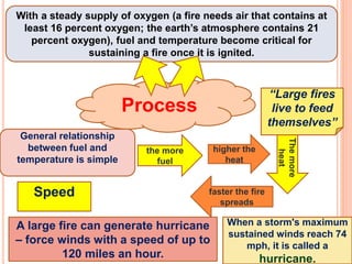
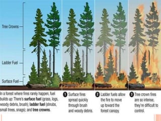
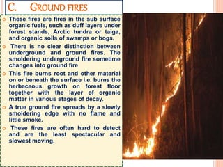
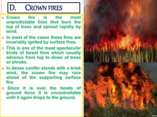
SlideShare a Scribd company logo
Title
“Forest Fire as an Evil or Necessity”
Department of Silviculture AND
AGROFORESTRY
CREDIT SEMINAR
AF- 591
SpeAker Avinash Kumar Bhatia
NF-2018-03-M
College of Horticulture and Forestry
Neri, Hamirpur (HP)
• Forest, its Definitions &
Productivity
• Fire- History & Definition
• Components of fire
• Fire Characteristics
• Fire triangle and Behavior
• Types of Forest Fire
• Causes
• Negative Impacts
• Positive Impacts
• Fire Statistics- World, India &
HP
• Management
• Prescribed Burning
• Case Studies
• Conclusion
CONTENT
Included
Forest
Food and Agriculture
Organization (FAO) of
United Nations defines
forest in a bit technical
sense as “Land with a
tree canopy cover of more
than 10 percent and area
of more than 0.5
hectare”.
Source: FAO
As far as the legal aspect is concerned, it has
nothing to do with tree canopy or the tree cover
and is simply defined as an area of land accorded
as “Forest” in the revenue records or proclaimed
to be forest under “Forest Law or Act”.
General Definition: A area set
aside for production of timber
and other forest produce, or
maintained under woody
vegetation for certain indirect
benefits which it provides, e.g.,
climatic or protective.
Ecological definition : A plant
community predominantly of trees
and other woody vegetation, usually
with closed canopy.
Recordedforest area can be classifiedas:
Reserved Forest
(RF)
Protected
Forest (PF)
Unclassified
Forest (UF)
I. They give valuable raw
materials.
II. They are considered rivals
for the space needed for crops
and flocks.
Present time, forests are viewedfrom twoangles:
At present the world’s total forest area is just over
4 billion hectares, which corresponds to an
average of 0.6 ha per capita (Global Forest
Resources Assessment 2015). World’s forests
store 289 gigatonnes (Gt) of carbon in their
biomass alone. In India per capita forest area is
only 0.064 ha (FAO).
As per State of Worlds Forest Report 2018, Europe
is the richest in forest cover forming around 45 percent
of the total forest cover of the world. In term of
percentage of land under forest cover, South America is
on the top, having nearly half of its land mass under
forest and in term of per capita forest area, Oceania
stands the first.
Productivity: India forest = 1.34 m3/ha/year
World Forest= 2.1 m3/ha/year
(FAO)
Fire
Fire is actually the heat and the light that results
when three elements i.e. fuel, oxygen and
Temperature (heat) are combined together.
The word “fire” evolved from the
Greek word “pyra” meaning growing
embers.
HistoryHistorically, fire has
played a significant
role in
environmental
change and
shaping the
progression of
human civilization
(Agee 1993).
In Indian mythology there are
many evidences, where fire
or Agni was worshiped and
respected as Agni Devta. In
Hindu mythology a full
volume on Agni Purana
already exists, which is solely
about the praise of this
mighty source of energy.
As far as the birth of fire is
concerned, fire emerged on
the earth with its origin only.
From the time our planet
came into existence,
lightening has sparked
landscape. Artificial or the
human induced fire began
when the earlier human being
first rubbed two stones.
Discovery of fire has been a
revolutionary invention of
human civilization.
Definition
• Forest fire may be defined as an unclosed
and freely spreading combustion that
consumes the natural fuels.
• Combustion is another word for fire.
• When a fire burns out of control it is known
as Wild Fire.
It is a chemical reaction of any
substance that will ignite and burn to
release a lot of energy in the form of
heat and light (Rawat, 2003)
Source: Forest
Fire Disaster
Management
 .
Fire Gas: These are the gases created by the combustion
process. They are invisible to the naked eye, but they exist
and include such poisonous substances as Carbon
monoxide.
Flame: This is the light given off by the burning gas. As long
as the three essential ingredients, fuel, oxygen, and heat are
there, it can be seen.
Heat: This is the part of the fire that one feels as warmth. A
normal fire usually burns at around 1,100º C.
Smoke: Smoke is a harmful vapor cloud mixed with a fine
powder of solid particles and some gases. The solid
particles in smoke create breathing and viewing problem
during fire.
INTRODUCTION
The most common hazard in forests is forests fire. (Brandis 1897,
Bahuguna and Upadhyay 2002). They pose a threat not only to the
forest wealth but also to the entire regime to fauna and flora seriously
disturbing the bio-diversity and the ecology and environment of a
region.
During summer, when there is no rain for months, the forests become
littered with dry senescent leaves and twigs, which could burst into
flames ignited by the slightest spark.
Forest fire causes imbalances in nature and endangers biodiversity by
reducing faunal and floral wealth. Traditional methods of fire
prevention are not proving effective and it is now essential to raise
public awareness on the matter, particularly among those people who
live close to or in forested areas.
Components of forest fire
Fire is the naturally occurring
companion of energy released
in the form of heat and light,
when oxygen combines with a
combustible or burnable
material at a suitable high
temperature (about 617 degrees
F, temperature or 325 degrees C
for wood to burn).
There are basically three
components i.e. fuel, heat and
oxygen that are needed in right
combination to produce fire.
Source: Forest Encyclopedia
Network & Ward, 2001
Process
With a steady supply of oxygen (a fire needs air that contains at
least 16 percent oxygen; the earth’s atmosphere contains 21
percent oxygen), fuel and temperature become critical for
sustaining a fire once it is ignited.
the more
fuel
higher the
heat
Themore
heat
faster the fire
spreads
“Large fires
live to feed
themselves”
General relationship
between fuel and
temperature is simple
When a storm's maximum
sustained winds reach 74
mph, it is called a
hurricane.
A large fire can generate hurricane
– force winds with a speed of up to
120 miles an hour.
Speed
FUELS FOR FOREST
FIRE
A CB
The materials which
constitutes the ground
fuels can be
summarized as follows
1. various decayed
stages of the humus,
2. trees, shrubs and
3. roots, muck and
peat.
This may include:
1. tree leaves and the
fine litter,
2. grasses, weeds,
ferns and the other
herbaceous plants,
3. seedlings and
saplings of trees,
4. fine deadwood on the
forest floor,
5. large logs and
stumps, and
6. roots of trees.
The main aerial fuels
include:
1. branches and
foliage of trees,
2. trees and shrubs of
the under storey,
3. standing dead
trees, and
4. mosses, lichens
and epiphytic plants
on trees.
Fuel is any material capable of burning. In
forests, fuels are vegetation, branches,
needles, standing dead trees, leaves, and
man-made flammable structures (Anon,
1999).
Ground fuels
Surface fuels Aerial fuels
FIRE CHARACTERISTICS
• Burning is the oxidation reaction that requires the proper
combination of heat, oxygen and fuel.
• Ignition will not occur until all three factors permit
combustion.
• Intensity of fire is expressed as British Thermal Units (1 BTU
= 252 cal.) per second per meter of fire front.
• The intensity is generally 1.5- 9000 BTU/sec/m in forest and
1.5- 2000 BTU/sec/m in grasslands as estimated by MC Arthor
& Cheney, 1966 in Australia. The no. of BTU per kg of fuel is
relative constant (1,87,000).
• Fire reaction intensity is the rate of heat release per unit area
and rate of spread i.e. if the quantity of fuel is doubled and
the rate of spread is also doubled the reaction intensity
increase four fold.
• Rate of combustion is faster when moisture content, particle
size and compactness of fuel is low.
Topography
Terrain, aspect,
exposure,
accessibility.
Fuels
Living and dead
vegetation,
organic soil
material.
Weather
Temperature,
rainfall,
humidity, winds.
People
Current and past
land management
practices, forest
resource use, fire
use, policies and
regulations, etc.
THE WILDFIRE TRIANGLE
Source: MOEF
Topography
Terrain, aspect,
exposure,
accessibility.
People
Current and past
land management
practices, forest
resource use, fire
use, policies and
regulations, etc.
THE WILDFIRE TRIANGLE
FIRE BEHAVIOR
• Knowledge of fire behavior is necessary for successful of fire in
forest management activities.
• Fire behavior changes with weather, topography and fuel.
• Fire control requires the unplanned increases in fire intensity and
rate of spread is kept minimum.
• Fire movement is controlled by three factors conduction, convention
and radiation.
• Higher is the temperature, lesser the energy required to raise fuel
temperature, leads to increase the fire intensity.
• Higher humidity lowers down the chances of forest fires.
• Steepness of the slope increases the fire spread.
• Wind has also direct relationship with fire spread.
Types of forest
fire
Basically forest fires can be sub
grouped into four types depending
upon their nature and size.
A. Surface
fires
C. Ground
fires
D. Crown
fires
B. Underground
fires
 Surface fire is the most common
forest fires that burn
undergrowth and dead material
along the floor of the forest.
 It is the type of fire that burns
surface litter, other loose debris
of the forest floor and small
vegetation.
 In general, it is very useful for
the forest growth and
regeneration.
 Surface fires spread by flaming
combustion through fuels at or
near the surface- grass, dead
and down limbs, forest needle
and leaf litter, or debris from
harvesting or land clearing.
A. SURFACE FIRES
B. UNDERGROUND FIRES
 The fires of low intensity,
consuming the organic matter
beneath and the surface litter of
forest floor are sub-grouped as
underground fire.
 In most of the dense forests a thick
mantle of organic matter is found on
top of the mineral soil. This fire
spreads in by consuming such
material.
 This fire spreads very slowly and in
most of the cases it becomes very
hard to detect and control such type
of fires.
 It may continue to burn for months
and destroy vegetative cover of the
soil. The other terminology for this
type of fire is Muck fires.
C. GROUND FIRES
 These fires are fires in the sub surface
organic fuels, such as duff layers under
forest stands, Arctic tundra or taiga,
and organic soils of swamps or bogs.
 There is no clear distinction between
underground and ground fires. The
smoldering underground fire sometime
changes into ground fire
 This fire burns root and other material
on or beneath the surface i.e. burns the
herbaceous growth on forest floor
together with the layer of organic
matter in various stages of decay.
 A true ground fire spreads by a slowly
smoldering edge with no flame and
little smoke.
 These fires are often hard to detect
and are the least spectacular and
slowest moving.
D. CROWN FIRES
 Crown fire is the most
unpredictable fires that burn the
top of trees and spread rapidly by
wind.
 In most of the cases these fires are
invariably ignited by surface fires.
 This is one of the most spectacular
kinds of forest fires which usually
advance from top to down of trees
or shrubs.
 In dense conifer stands with a brisk
wind, the crown fire may race
ahead of the supporting surface
fire.
 Since it is over the heads of
ground force it is uncontrollable
until it again drops to the ground.
Firestorms
Among the forest fires, the fire
spreading most rapidly is the
firestorm, which is an intense fire
over a large area. As the fire
burns, heat rises and air rushes
in, causing the fire to grow. More
air makes the fire spin violently
like a storm. Flames fly out from
the base and burning ember spew
out the top of the fiery twister,
starting smaller fires around it.
Temperatures inside these storms
can reach around 2,000 degrees
Fahrenheit.
A fire is said to be running when it is spreading rapidly.
It is creeping when it is spreading slowly with low flames.
A fire is smoldering when it burns without a flame and is
barely spreading.
A fire is said to be spotting when it is producing sparks or
embers that are carried by the wind.
A fire is torching when it moves from one crown to another
fire into the crowns of individual trees, but not necessary
from one crown to another.
It is crowning when it spreads from tree to tree usually in
conjunction with, but sometimes completely independent of
the surface fire.
A flare-up is a sudden acceleration of fire spread or intensity,
of relatively short duration for a portion of the fire.
A blowup, on the other hand is a dramatic change in the
behavior of the whole fire, the point of rapid transition to a
severe fire.
Why forests fire
More than ninety five
(95%) percent forest fires
are caused either by
negligence or
unknowingly by the
human being.
The rest of the fires are
caused by natural reasons i.
e. lightning, extreme rise in
the temperature etc., which
are very rare.
In general all over the world
the main causes of forest
fires are anthropogenic.
According to FAO
report “Fire
Management-
Global
Assessment
2006”, regional
estimates of
human induced
forest fires as
follows:
a. Mediterranean- 95%
b. South Asia 90 %
c. South America 85 %
d. North America 80 %
e. Balkan countries 59 %
Causes of Forest Fire
Natural causes Anthropogeniccauses
Out of three essential components of fire
triangle, two components i.e. fuel and
oxygen are naturally available in forest. It
is the third component i.e. heat that really
initiates fire in the forest. Depending
upon the source of the heat:
Deliberate
causes
Accidental
causes
NATURAL CAUSES
(ENVIRONMENTAL CAUSES)
Many forest fires start from natural causes such as lightning
which set trees on fire. However, rain extinguishes such fires
without causing much damage. High atmospheric temperatures
and dryness (low humidity) offer favorable circumstance for a
fire to start.
Environmental causes are largely related to climatic conditions
such as temperature, wind speed and direction, level of moisture in
soil and atmosphere and duration of dry spells.
Other natural causes are the friction of bamboos swaying due to
high wind velocity and rolling stones that result in sparks setting off
fires in highly inflammable leaf litter on the forest floor.
Anthropogeniccauses
A. Deliberate or intentional causes
i) Shifting cultivation.
ii) To get good grass / fodder crop.
iii) To get better flush for tendu
leaves.
iv) For concealing the illicit felling.
v) For cleaning forest paths by
the villagers.
In the northeastern parts of India, the practice of slash-and-burn shifting
cultivation is the leading cause of forest destruction. The most heavily affected
areas are Arunachal Pradesh, Assam, Manipur, Meghalaya, Mizoram, Nagaland
and Tripura. Nationally, estimated 4.35 million hectare areas are affected by fire
as part of shifting cultivation. This is especially significant in that with the
growth of population and consequent decrease in the land/person ratio, not
only more areas are subjected to shifting cultivation, but also the fallow period
for regeneration has been reduced from the initial thirty years to two years.
FAO report “Fire Management- Global Assessment 2006
B. Accidental or
Unintentional causes
Many times due to
negligence, even small
fires may result into
devastating fires. Some
of the main unintentional
reasons for such fires
are:
i) Collection of Non Timber Forest Produce (NTFP)
ii) Burning farm residue
iii)Protecting crops from the wild animals
iv) Careless throwing of cigarettes, bidi stubs, match sticks by
grazers/ travelers
v) Negligence in camp fires and working operations near camping ground
and fairs
vi) Sparks from transformers or vehicles passing through the forest
vii) Uncontrolled prescribed burning
viii) Resin tapping
ix) Charcoal making and wine extracting in the forest
x) Heating coal tar for road construction
xi) Hunting by tribals
FAO report “Fire Management- Global Assessment 2006
1. Loss of valuable timber resources
Timber quality is affected by
scorching from the base of
the tree, which damages the
cambium, leading to
defective butt logs. Fungal
infection may occur through
the damaged tissues and
cause rot. In chir pine
forests, resin tapping affects
the yield of merchantable
timber by damaging the
lower part of the tree; the
scars enable fires to bum
into the heartwood and, in
some cases, kill the tree.
Forest fires cause
indispensable loss to
timber and deteriorate its
quality. Valuable timber
species like teak, sal, chir,
deodar, sheesam,
rosewood etc. are
adversely affected by fire.
However, the adhesive
impact of forest fire varies
from species to species,
depending upon its
susceptibility.
2. Impact of forest fire on eco system
The most damaging impact of forest fire on ecosystem is
very evident in the Himalayas, where hills existing between
the heights of 1000 to 1800 meters are dominated by pine
forests and seem to be more fire prone. Most of these forests
have preceding fire history; repeated fires have converted
mixed forests of oak and chir to pure chir forest. Of course,
chir pine was also planted in these areas but one of the
principal reasons for the conversion of mixed forests of oak
and chir is the occurrence of repeated and uncontrolled fires.
Uncontrolled fires have made the situation less favourable
for oaks to grow and more favourable for chir to grow.
3. Degradation of water catchments areas
resultingintoloss of water:
• After forest fire, soil moisture is
decreased and litter decomposition
becomes almost negligible, which
creates a possibility of forest fire in
future.
• Just after fire, the chemical and
physical changes in upper layer of
soil make it impervious and thus
reduce water infiltration.
• The removal of litter also
decreases water holding capacity of
soil and most of the rainwater is
washed away removing top fertile
soil of the forest resulting into loss
of soil fertility.
4. Loss of wildlifehabitat and depletion of
wildlife:
• Wildfire along with killing
wild animals also destroys
their habitat and thus makes
their survival at stake.
• Forest fire dramatically
impacts the animal life.
• Animals are first to lose
their lives due to heat
generated.
• Eggs of birds and insects
are destroyed due to fire
impact.
5. Global warming
One of the major culprits of climate change is forest
fire. The immediate effect of vegetation burning is
the production and release of gases including
carbon dioxide, carbon monoxide, methane, non-
methane hydrocarbons, nitric oxide, methyl
chloride and various other gases, which are
released and returned to the atmosphere in a matter
of hours. The burning of forest also destroys an
important sink for atmospheric carbon dioxide.
Hence, burning has a significant role in the world’s
carbon dioxide budget. International Centre for
Integrated Mountain Development (ICIMOD)
working in Hindukush Mountains pins the blame on
global warming for creating the conditions that led
to fires. Some foresters blame record high
temperatures and the failure of winter rains for
destruction through fire of hundreds of hectares of
natural forest in the Garhwal Himalayas in India and
in eastern and central regions of Nepal in 2006.
As per FAO report
“Fire Management-
Global Assessment
2006”, the quantity
of biomass burned
each year from all
resources is about
9200 million tones.
Overall global fires
in vegetation
consume 5130
million tones, 42
percent of which is
in Africa. This
burning releases
about 3431 million
tones of CO2 and
other emissions.
The fires in the forest are source of
smoke that cause air pollution and rise
in the temperature. The forest fires in
1995 and 1999 in Himalayan states
gutted the mountains with the smoke,
resulting into loss of visibility to about
200 meters. The temperature in the
region also rose by 2 to 3 degree
Celsius.. Scientific studies of major
forest fire of South East Asia of 1997
came out with many new findings. These
fires were unique, since they involved
both the burning of above ground
vegetation, as well as the below ground
i.e. peat (a form of coal). This fire
generated smoke covered almost all of
South East Asia resulting into more than
20 million cases of smoke related health
problems.
According to Punjab
Pollution Control
Board (1 November
2019), 46% of Delhi
Air Pollution is from
stubble burning;
Punjab records 25%
jump.
In the western countries,
especially in the United States,
forest fires cause enormous
loss to house buildings. As per
an estimate, forest fires burned
around 10,000 houses in the
United States between 1985 and
2000. In 2000 alone, at least 800
family houses were destroyed
by wild fires in that country.
6. Adverse impact on Healthsystem
Trees act as carbon sinks when they absorb carbon
dioxide from atmosphere and build up the same in the
form of wood.
Hardwood contains 48 percent of carbon in the form
of cellulose and wood and it is estimated that 2.2
tones of wood are required to sequester one ton of
carbon.
Burning of the vegetation release hundreds of years of stored
carbon- di- oxide (CO2) into the atmosphere, and thus results
into permanent destruction of important sink of carbon dioxide.
7. Carbon sequestration potential
Fire statistics
Recently Global Forest Resources Assessment -
2010 (a report prepared by FAO- UN) compiled
information about forest fires from different
countries all over the world. The main findings of
the report about forest fire situation are as
follows:
In 118 countries (having 65 percent of world forest cover) 19.8 million
hectare of forest is affected by fire annually. This area represents less
than one percent of the forest in these countries.
The largest areas of forest affected by fire were reported in Chad,
Australia, United States of America, India and Canada, which all reported
an average of more than 1 million hectares of forest burnt annually.
 Regarding the number of fires; as per the data compiled from 64
countries (representing 60 percent of the global forest area) an average of
487000 vegetation fires occurred per year during the period 2003-2007 in
forests.
 In terms of the number of forest fires, 81 countries, representing 50
percent of the global forest area, reported an average of 156,000 forest
fires per year during the period 2003-2007 (i.e. an average of around 1900
forest fires per country per year).
 94 percent of the total forest area affected by fire was due to wildfires
and only 6 percent due to planned fires.
The National Institute for Space Research (Inpe), Brazil said that its
satellite data showed that Amazon fires increase by
an 84% increase on the same period in 2018.
Fire damages the tree, shrubs and plants. Globally, more than 350 m ha
of forests was burned in 2000, equal to 6% of the world’s geographical
area (FAO, 2007). The extent of damage depends on the species, age,
intensity of fire and vegetation types.
.
According to K. Manoj and R. Abhishek , the forest tree biomass and carbon also
decreased in south-western aspects (9.47 t ha-1 and 38.54 t ha-1) than north-
western site (62.54 t ha-1 and 49.93 t ha-1), where fire frequency is every year.
According to Sheuyange et al. (2005), frequent fires reduced shrub cover
temporarily and promoted herbaceous cover. However, the frequent fires
positively influenced the herbaceous and tree species.
A recent analysis done by FSI, shows that nearly 36% of country’s
forests are prone to fires and of this, over 10% are highly prone.
Region/sub region Information Availability Area of forest affected by fire
Number of
countries
% of total
forest area
1000 ha % of forest area
Eastern and Southern Africa 8 29.3 452 0.6
Northern Africa 5 10 17 0.2
Western and Central Africa 8 19.7 7849 11.9
Total Africa 21 22.4 8318 5.4
East Asia 5 100 549 0.2
South and Southeast Asia 8 83.3 1859 0.7
Western and Central Asia 16 51.7 50 0.2
Total Asia 29 87.9 2457 0.5
Europe excl. Russian Federation 41 96.6 270 0.1
Total Europe 42 99.4 1262 0.1
Caribbean 7 74.1 15 0.3
Central America 4 72.6 107 0.7
North America 4 100 3437 0.5
Total North and Central America 15 98.9 3558 0.5
Total Oceania 6 82.5 3903 2.4
Total South America 5 14 333 0.3
Source : FAO FRA- 2010
Average area of forest annually affected by
fire by region and sub-region, 2005
Districts with high incidence of forest fires
Source:StateofForestReport(FSI),2009
Type of fire damage No. of
Grids*
Forest
Cover** (in
km 2 )
% of Total forest cover
Extremely fire prone 665 25,617 3.89
Highly fire prone 2,259 39,500 6.01
Fire prone 3,708 75,952 11.50
Moderately fire prone 5,496 96,422 14.70
Less fire prone 57,489 4,20,625 63.90
Total 69617 6,58,116 100.00
Forest cover in different fire prone classes
Source: State of Forest Report of 2019 (FSI)
4%
6%
11%
15%
64%
Extremely fire prone
Highly fire prone
Fire prone
Moderately fire prone
Less fire prone
Forest cover in different fire prone classes
Source: State of Forest Report of 2019 (FSI)
Map Showing fire prone forest areas under different fire prone classes
List of top 10 States in terms of percentage of forest cover in extremely
fire prone areas is given below:
Sl. No. STATE / Uts % of Forest Cover under extremely fire
prone class
1 Mizoram 29.91
2 Tripura 26.95
3 Assam 21.98
4 Meghalaya 5.74
5 Manipur 4.48
6 Andhra Pradesh 4.27
7 Telangana 4.21
8 Chhattisgarh 3.90
9 Maharashtra 3.40
10 Nagaland 3.05
Source: State of Forest Report of 2019 (FSI)
S. No. State/ Year Location Area affected (ha) Source
1. Uttrakhand, 1995 Uttarakhand hills 3, 75,000 Kaushik, 2004
2. India, 1999 Ganga Yamuna watershed 80,000 Kaushik, 2004
3. Himachal Pradesh June
2007
Shimla & Solan Districts 2000 (Reserve
forest)
EMDAT
4. Maharastra 15 June 2008 Melghat gugamal National park
in Maharastra
10000 Anonymous
5. Gujarat Feb-09 Gir forest, Gujrat 32.38 Anonymous
6. 2009- March India Taboda Researve forest 50 Anonymous
7. 2009- March India Chamundi Hills 20 Anonymous
8. April 2009, India BaHadson Beer 200 Anonymous
9. Uttrakhand, April 2009 Chamoli/Gochar/
Devprayag/Hrishikesh
5 The Hindu, Apr
21, 2009
10. 2009 India Way Land 424 Anonymous
11. Maharashtra Jan-May2010 Mumbai 10300 Anonymous
12. Nagaland 18-Feb-10 Tuesang District in nagaland 4 Anonymous
13. Himachal Pradesh Jun-10 Himachal Pradesh 19,109 Anonymous
14. TamilNadu, 2011 Ooty in Nilgiris 10 hectares
(Reserve forest)
TOI,TNN Mar 8,
2011
Major forest fire in Indian States during 1990-2011
State and UTs Jan Feb Mar Apr May June July Aug Sep Oct Nov Dec
Assam * ** ** * * X X X X X X *
Andaman & Nicobar
Islands
** ** ** * * X X X X X X *
Andhra Pradesh X * ** ** ** * X X X X X X
Bihar X * ** ** ** X X X X X X X
Dadr & Nagar Haveli * * ** ** ** * X X X X X X
Gujarat * * ** ** ** * X X X X X X
Goa, Daman and Diu X * ** ** ** X X X X X X X
Haryana * * * ** ** ** X X X * * *
Himachal Pradesh * * * ** ** ** X X X * * *
Karnataka * ** ** ** * * X X X X * *
Kerala * * ** ** ** * X X X X X *
Maharasthra X * ** ** ** * X X X * * X
Madhya Pradesh * * ** ** ** X X X X * * *
Nagaland X * ** * X X X X X X X X
Punjab X * * ** ** ** X X X X X X
Rajasthan * * ** ** ** * X X X X X X
Sikkim * * ** ** * X X X X X X X
Tamil Nadu * ** ** ** ** X X X X X * *
Uttar Pradesh * * ** ** ** X X X X X X *
Forest fire season in India (Annual) Source: FORTECH: FAO: TCP/IND/4452
(** Peak fires Season;; * Additional months of fire occurrence; X No fire.)
Forest Fire in Himachal Pradesh
The forests of Western Himalayas are more frequent vulnerable to forest
fires as compared to those in Eastern Himalayas. Frequency and intensity
of forest fires has been increased since 1990 in Himalayan region. Forest
fires are an annual phenomenon in state of Himachal Pradesh. This is a
most frequent hazards.
Fire season starts from mid-April, when there is no rain for months, forests
become littered with dry senescent leaves and twinges, which could burst
into flames or ignited by the slightest spark. In June 2007, forest fire
destroyed 2,000 hectares of forest in Himachal Pradesh (SAARC-DM
Center, 2007).
Forest fires are mostly anthropogenic in nature in Himachal Pradesh and
may occur due to the following reasons:
1. Forest floor are often burnt by villagers to get a good growth of grass in
the following season or for a good growth of mushrooms,
2. Wild grass or undergrowth is burnt to search for animals,
3. Firing by miscreants,
4. Attempt to destroy stumps of illicit fallings.
Land Type Area (in Sq. Km) % of Total Area
Forest Area (Forest Record) 37,033 67%
Land put to Non-agricultural uses 4,716 8%
Net area sown 5,414 10%
Fallow Lands (Current & other Fallows) 752 1%
Culturable Wastes 1,280 2%
Land under misc. tree crops not
included in cultivation
611 1%
Permanent pastures and other grazing
lands including alpine pasture, barren
& un-culturable lands including alpine
pastures, barren & un-culturable waste
etc.
5,867 11
Total Geographical Area 55,673 100
Source: Himachal Pradesh Forest Department,
Govt. of HP
District Geo.
Area (Sq.
Kms.)
Forest
Area (Sq.
Kms.)
Tree covered area (Sq. Km.) % of Geo.
Area
Forest Fire
incidents
during
2005-12
Very
Dense
Forest
Moderate
Dense
Forest
Open
Forest
Total
Forest
Cover
Bilaspur 1,167 428 24 171 167 362 31.02 10
Chamba 6,522 5,030 853 773 810 2,436 37.35 15
Hamirpur 1,118 219 39 92 114 245 21.91 15
Kangra 5,739 2,842 310 1,221 531 2,062 35.93 46
Kinnaur 6,401 5,093 82 263 257 602 9.40 2
Kullu 5,503 4,952 586 789 583 1,958 35.58 31
Lahaul & Spiti 13,841 10,133 15 32 146 193 1.39 37
Mandi 3,950 1,860 373 735 565 1,673 42.35 69
Shimla 5,131 3,418 739 1,037 608 2,384 46.46 29
Sirmaur 2,825 1,843 130 568 685 1,383 48.96 39
Solan 1,936 728 55 404 390 849 43.85 104
Una 1,540 487 18 298 205 521 33.83 85
Total 55,673 37,033 3,224 6,383 5,061 14,668 26.35 482
Source: Forest Department, Govt. of HP, Forest Survey of India, Dehradun
3% 3%
10% 0%
7%
8%
15%
6%8%
22%
18%
Chamba
Hamirpur
Kangra
Kinnaur
Kullu
Lahaul & Spiti
Mandi
Shimla
Sirmaur
Solan
Una
Forest Fire incidents during 2005-12
Himachal Pradesh Forest Department
Forest fire: as A management tool
Although fire has been the primary
agent of deforestation, yet as a
natural process it serves an
important function in maintaining the
health of certain ecosystems.
For decades, controlled burning has
been used as a genuine forest
management measure in the developed
countries. In western countries,
especially Britain, U.S.A., Canada etc.
controlled fires are burnt at intervals of
10-12 years to maintain uniform growth.
In South and Southeast Asia, including
India, “Slash and Burn” method of
farming is used by the tribals of hilly
areas, in which they cut down and burn
small areas of the forest and use the
cleared land for cultivation. This
method of burning offers them not only
the cheapest means to clear the forest,
but also supplies free fertilizers in the
form of ash from the burnt vegetation
on limited scales.
1. Reduce the buildup of fuel, and
thus intensity of future burns.
2. Recycle nutrients bound up in
litter.
3. Reduce competition, allowing
existing trees to grow larger.
4. To remove unpalatable growth
remaining from previous seasons.
5. To stimulate growth during
seasons when there is little green
grazing.
Depending upon the nature of the
ecosystem, the weather, and the amount
of fuel available(Kayll 1974, Viro 1974,
Terry et al. 1996),fire helps the forest in
following ways:
6. To control or destroy insect and disease.
Forest fire- a bad master“Fireisagoodservantbutabadmaster”
• Limited and controlled forest fires have been very
useful and essential for healthy forest growth.
• But uncontrolled forest fire may engulf and destroy
healthy thick forest cover within no time.
• Besides direct loss to forest cover, forest fire also
kills wildlife, damages environment, degrade soil
quality and retrogrades forest regeneration.
•Fire always causes many direct or indirect effects on
the forest ecosystem. They may merely be beneficial
but at most of the times these effects are
deteriorating. The damage to a forest by fire depends
mainly on size of the fire.
As reported in the Global Forest
Resources Assessment (GFRA),
2010 the recent examples of
human lives loss due to forest
fire include- Victoria in Australia
in 2003 causing 73 fatalities and
Greece fires in 2007 resulting
into 70 deaths..
Large uncontrolled forest fires
result into health problems
due to fire generated smoke.
Breathing problems, skin
irritation, loss of visibility and
other related problems are
very common during forest
fire.
The loss to
timber, loss of
soil fertility,
soil erosion,
drying up of
water sources
and loss to
biodiversity are
immeasurable
losses by
forest fire.
Ministry of Environment and Forests has introduced a centrally
sponsored scheme namely “Modern Forest Fire Control Methods” since
1992-93
The objectives of this scheme are:
(i) To control forest fires with a view to protect and conserve
forests.
(ii) To devise, test and demonstrate the principles and techniques
of forest fire management.
(iii) To improve the productivity of forests by reducing incidence
and extent of fire.
(iv) To create awareness among the masses about the effects of
forest fires on the forests and environment.
(v) To conduct training programmes for the forest officials and
local people to prevent, detect and control forest fires.
Near Real Time Forest Fire Detection System Developed by FSI
• Geospatial point data showing forest fires provided by National Remote
Sensing Centre (NRSC) is acquired and provided to FSI on near real time
basis.
• The active fire spots or hotspots are generated by using MODIS and
SNPP-VIIRS satellite sensors. The locations of fires as received from
NRSC are regardless of land use and land cover.
• These coordinates are superimposed on the latest forest cover map of
India, prepared by Forest Survey of India, to eliminate any fire hotspots
coming from industrial, agricultural or any other sources other than
forest.
•Attributes like state, district and Survey of India 1:50000 topo-sheet’s
numbers are attached with each coordinate of the forest fire locations as
attribute information. The processed forest fire information is then
converted into *.KML (Keyhole Mark-up Language) format, and is e-mailed
to the appointed nodal officers of each state. The sms messages are also
sent to every registered user in the country.
•Forest fire detection and dissemination of alerts is done twice daily
during the fire season i.e December to next year June. This activity is
being done in FSI since 2004.
THE FOREST FIRE
PREVENTION AND MANAGEMENT (FFPM) CYCLE
PREVENTION
DETECTION
SUPPRESSION
POST-FIREMANAGEMENT
To meet the aforementioned
objectives financial support is
provided under following
subheads:
Prevention: Creation of fire lines,
training and demonstration
publicity.
Detection: Construction of watch
towers, network of wireless sets,
fire finders.
Suppression: Hand tools, fire
resistant clothing and fire
tenders.
THE MOST FREQUENTLY USED FIRE DETECTION AND SUPPRESSION
Source: Ahmad A. A. Alkhatib; A
Review on Forest Fire Detection
Techniques.
Detection and monitoring
systems are divided into
the following two basic
groups:
(a) volunteer reporting:
public reporting of fires,
public aircraft, and ground
based field staff
(b) operational detection
systems: fire towers, aerial
patrols, electronic
lightning detectors, and
automatic detection
systems.
Techniques employed by authorities can be
summarized as follows:
(i) controlled burning,
(ii) fire weather forecasts and
estimates of fuel and moisture,
(iii) watch towers,
(iv) optical smoke detection,
(v) lightning detectors which
detect the coordinates of
the strike,
(vi) infrared,
(vii) spotter planes,
(viii) water tankers,
(ix) mobile/smart phone calls
becoming increasingly common
for detecting fires early, and
(x) education through Fire Watch
or similar schemes for house
owners.
Prescribed burning
Prescribed burning is the
process of planning and
applying fire to a
predetermined area, under
specific environmental
conditions, to achieve a
desired outcome.
Prescribed, controlled
and planned burns are the
same thing.
Objectives:
1. Alter the vegetation
composition.
2. Increase Livestock forage
production.
3. Increase quality of forage.
4. Prepare land for seeding.
5. Reduce hazards of wildfires. US Forest Service, 1989
Process
1. Planning of
Prescribed fire
2. Preparation of Site
5. Designs for igniting
prescribed burns.
6. Post Fire
Management
3. Pre- alarming
4. Weather and Fuel
prescriptionUS Forest
Service 1989
CASE STUDIES
1. Wink, R.L., and H.A. Wright. 1973. Effects of fire on an Ashe juniper
community. Journal of Range Management. 26(5):326-329.
In an Ashe juniper community, a minimum of 1000 kg/ha of fine fuel was
needed to carry a fire to kill juniper seedlings and burn piles of dozed
juniper. Grasses recovered quickly and soil erosion was minimal when
burned during a wet winter and spring. During a dry winter and spring,
however, burning increased drought stress on plants, reduced herbaceous
yields, and exposed soil to wind and water erosion for a long period of time
when soil moisture was low.
2. Mutch, R.W., 1976. Fire management and land use planning today: tradition
and change in the Forest Service. Western Wildlands 3(1):13-19.
The author discusses the necessity of changing from fire control to fire
management, in which fire management is integrated with fire ecology
principles and land-use planning requirements. The author presents traditional
approaches and current trends by using a survey of fire management
personnel, which shows that managers are interested in natural fire
management, while also aiming to improve suppression ability. The author
points out that wildland fire should be regarded as an ecological process as
well as a management tool. Also argues that successful fire management may
be achieved by informing the public, applying research results, and increasing
understanding of the role of both fire prevention and prescribed burning in
3. The effects of fire and grazing on stability and dynamics of savanna grassland
communities in the Kalakad-Mundanthurai Tiger Reserve, South India, Mahesh
Sankaran, University of Leeds, UK
An experimental study aimed at investigating the individual and interactive effects
of fires and mammalian grazing on savanna-grassland plant community
composition and diversity was initiated in 1997. A primary objective of the study
was to examine the responses of unpalatable tall-grass species to these
perturbations, and thereby evaluate the effectiveness of fire as a tool to control
tall-grasses and improve herbivore habitat quality in the reserve. Three different
sites, dominated by the unpalatable tall-grass species Cymbopogon flexuosus,
were selected for this study. None of the burning treatments had any significant
effect on the cover of the tall-grass species C. flexuosus in plots, suggesting that
this species is highly resistant to fire.
At global level an estimated 150 to 250 million ha (Mha) of the recorded
1.8 billion ha of tropical forests are affected by wildfire annually. In the
Amazonian forests for instance, wildfire has been reported to cause
high mortality in many useful species with the rate ranging between 36-
96%. In Ghana, (one of the leading exporters of timber in Africa), for
instance, wildfires caused more than 4 million m3 of exportable timber in
losses between 1982-1983. An estimated annual loss of 3% of GDP was
recorded for the past two decades, due to wild fires. In South East Asia,
the loss of tropical forest resources was much higher. Areas (in Java,
Borneo, Sulawesi, Irian Jaya and Sumatra) in Indonesia which were the
most affected in Asia lost about 9.5 Mha of land to fires, out of which
about 4.6 Mha (49%) was forested. For the same period, Brazil lost an
estimated 3.3 Mha hectares of land of which 1.5 million was rainforest in
northern Amazonia alone. In Mexico and Central America a further 1.5
million hectares was burnt affecting biodiversity and ecosystem
processes. During the same period, over 5 million hectares of temperate
forests were also affected in the United States and Canada and 2 million
hectares in Russia (Rowell and Moore, 2000).
4. Acc. to Mark Appiah (2007); FIRE: A NECESSARY EVIL
CONCLUSION
 “Forests can no longer be used in the same way as they have
been in the past. Forest products and services must be
assured through new political choices and policy decisions
that ensure the survival of forests.”
 It become very important to have effective forest
management plans with people participation.
 “Prevention is better than cure” i.e. by clearing the forest
floor before the peak season of fire.
 In this review, the requirement of accurate and precise
baseline data and its deficiency in India were pointed out as
background.
 The present day technology has been evaluated and suitable
suggestions were made to improve the technology by
keeping the objective of effective fire management.
 The potential indicators were identified and their data
sources were acknowledged. The present policies and
programs were reviewed and the need to develop an adaptive
management strategy was emphasised.
Thankyou

More Related Content

What's hot

The forest fire
The forest fireThe forest fire
The forest fire
Ajay Guleria
 
Forest fire
Forest fireForest fire
Forest fire
Daiboshree
 
Forest fires in india
Forest fires in indiaForest fires in india
Forest fires in india
Abhishek Sharma
 
Mitigation of Wildfire
Mitigation of WildfireMitigation of Wildfire
Mitigation of Wildfire
Prince Iwufred
 
Forest resources of india.ppt
Forest resources of india.pptForest resources of india.ppt
Forest resources of india.ppt
Hemant Kumar
 
Geography: Nuclear Disaster
Geography: Nuclear Disaster Geography: Nuclear Disaster
Geography: Nuclear Disaster
Paakhi Bhatnagar
 
Wild Fire season
Wild Fire seasonWild Fire season
Wild Fire season
Abu B. Kurian
 
Chemical disasters
Chemical disastersChemical disasters
Chemical disasters
MALLIKARJUNA REDDY KASIREDDY
 
Natural hazards and disaster management
Natural hazards and disaster managementNatural hazards and disaster management
Natural hazards and disaster management
Eternal University Baru Sahib, HP, India
 
Nuclear disasters
Nuclear disastersNuclear disasters
Nuclear disasters
MALLIKARJUNA REDDY KASIREDDY
 
The waste land reclamation
The waste land reclamationThe waste land reclamation
The waste land reclamation
OPTOM FASLU MUHAMMED
 
Wildfires
WildfiresWildfires
Supercyclone of Odisha
Supercyclone of OdishaSupercyclone of Odisha
Supercyclone of Odisha
Sidhartha Baral
 
Natural disasters of india
Natural disasters of indiaNatural disasters of india
Natural disasters of india
Bharthe Maheswaran
 
Forest management
Forest management Forest management
Forest management
DrMeenakshiPrasad
 
NATURAL AND MAN MADE DISASTERS
NATURAL AND MAN MADE DISASTERSNATURAL AND MAN MADE DISASTERS
NATURAL AND MAN MADE DISASTERS
umang singhania
 

What's hot (20)

The forest fire
The forest fireThe forest fire
The forest fire
 
Forest fire
Forest fireForest fire
Forest fire
 
Forest fires in india
Forest fires in indiaForest fires in india
Forest fires in india
 
Mitigation of Wildfire
Mitigation of WildfireMitigation of Wildfire
Mitigation of Wildfire
 
Forest resources of india.ppt
Forest resources of india.pptForest resources of india.ppt
Forest resources of india.ppt
 
wasteland reclamation
wasteland reclamationwasteland reclamation
wasteland reclamation
 
Natural hazards wildfires
Natural hazards   wildfiresNatural hazards   wildfires
Natural hazards wildfires
 
Geography: Nuclear Disaster
Geography: Nuclear Disaster Geography: Nuclear Disaster
Geography: Nuclear Disaster
 
Wild Fire season
Wild Fire seasonWild Fire season
Wild Fire season
 
Fire & the forest
Fire & the forestFire & the forest
Fire & the forest
 
Chemical disasters
Chemical disastersChemical disasters
Chemical disasters
 
Natural hazards and disaster management
Natural hazards and disaster managementNatural hazards and disaster management
Natural hazards and disaster management
 
Nuclear disasters
Nuclear disastersNuclear disasters
Nuclear disasters
 
The waste land reclamation
The waste land reclamationThe waste land reclamation
The waste land reclamation
 
Wildfires
WildfiresWildfires
Wildfires
 
Wildfires
WildfiresWildfires
Wildfires
 
Supercyclone of Odisha
Supercyclone of OdishaSupercyclone of Odisha
Supercyclone of Odisha
 
Natural disasters of india
Natural disasters of indiaNatural disasters of india
Natural disasters of india
 
Forest management
Forest management Forest management
Forest management
 
NATURAL AND MAN MADE DISASTERS
NATURAL AND MAN MADE DISASTERSNATURAL AND MAN MADE DISASTERS
NATURAL AND MAN MADE DISASTERS
 

Similar to Forest Fire- its impacts, case studies

wildfires-220101122849 (1).pdf
wildfires-220101122849 (1).pdfwildfires-220101122849 (1).pdf
wildfires-220101122849 (1).pdf
ahmed033642
 
Forest fire
Forest fireForest fire
Forest fire
Astha Dwivedi
 
Vegetation development dynamics of fire experimental plots at olokemeji fores...
Vegetation development dynamics of fire experimental plots at olokemeji fores...Vegetation development dynamics of fire experimental plots at olokemeji fores...
Vegetation development dynamics of fire experimental plots at olokemeji fores...
Alexander Decker
 
Forest Fire in India (UK)
Forest Fire in India (UK)Forest Fire in India (UK)
Forest Fire in India (UK)
Manish Bale
 
Technology will destroy our planet-Shana Ankersmit
Technology will destroy our planet-Shana AnkersmitTechnology will destroy our planet-Shana Ankersmit
Technology will destroy our planet-Shana Ankersmit
Shana Ankersmit
 
Jiaming
JiamingJiaming
Jiamingihsl
 
An Approach For Identifying The Forest Fire Using Land Surface Imagery By Loc...
An Approach For Identifying The Forest Fire Using Land Surface Imagery By Loc...An Approach For Identifying The Forest Fire Using Land Surface Imagery By Loc...
An Approach For Identifying The Forest Fire Using Land Surface Imagery By Loc...
IOSR Journals
 
wildfire is an uncontrolled fire in an area where there is (1).pdf
wildfire is an uncontrolled fire in an area where there is (1).pdfwildfire is an uncontrolled fire in an area where there is (1).pdf
wildfire is an uncontrolled fire in an area where there is (1).pdf
Sushmitakaushik1
 
Natural Disaster
Natural DisasterNatural Disaster
Natural Disaster
shivangipatel54
 
wildfire-prevention-campaign[1][1].pptx
wildfire-prevention-campaign[1][1].pptxwildfire-prevention-campaign[1][1].pptx
wildfire-prevention-campaign[1][1].pptx
DEBAYONMONDAL
 
Soumya Sharma disaster resilience ppt 1.pptx
Soumya Sharma disaster resilience ppt 1.pptxSoumya Sharma disaster resilience ppt 1.pptx
Soumya Sharma disaster resilience ppt 1.pptx
shobhit457jain
 
Cochrane & schulze, 1999. Fire as a recurrent event in tropical forests o...
Cochrane & schulze, 1999. Fire as a recurrent event in tropical forests o...Cochrane & schulze, 1999. Fire as a recurrent event in tropical forests o...
Cochrane & schulze, 1999. Fire as a recurrent event in tropical forests o...
Izabelle Lopes
 
finalseminar2.ppt
finalseminar2.pptfinalseminar2.ppt
finalseminar2.ppt
aniketYadav377701
 
The role of forest and soil carbon sequestrations on climate change mitigation
The role of forest and soil carbon sequestrations on climate change mitigationThe role of forest and soil carbon sequestrations on climate change mitigation
The role of forest and soil carbon sequestrations on climate change mitigation
Alexander Decker
 
Forest fires.pptx
Forest fires.pptxForest fires.pptx
Forest fires.pptx
AzraParveen19
 
ACE-ECO-2021-1999.pdf
ACE-ECO-2021-1999.pdfACE-ECO-2021-1999.pdf
ACE-ECO-2021-1999.pdf
AproximacionAlFuturo
 
09forest fires climatechange
09forest fires climatechange09forest fires climatechange
09forest fires climatechange
suraj_rsgis
 
Science physics
Science physicsScience physics
Science physics
PratheetGudisagar
 

Similar to Forest Fire- its impacts, case studies (20)

wildfires-220101122849 (1).pdf
wildfires-220101122849 (1).pdfwildfires-220101122849 (1).pdf
wildfires-220101122849 (1).pdf
 
Forest fire
Forest fireForest fire
Forest fire
 
Vegetation development dynamics of fire experimental plots at olokemeji fores...
Vegetation development dynamics of fire experimental plots at olokemeji fores...Vegetation development dynamics of fire experimental plots at olokemeji fores...
Vegetation development dynamics of fire experimental plots at olokemeji fores...
 
Forest Fire in India (UK)
Forest Fire in India (UK)Forest Fire in India (UK)
Forest Fire in India (UK)
 
Technology will destroy our planet-Shana Ankersmit
Technology will destroy our planet-Shana AnkersmitTechnology will destroy our planet-Shana Ankersmit
Technology will destroy our planet-Shana Ankersmit
 
Jiaming
JiamingJiaming
Jiaming
 
Fire
FireFire
Fire
 
An Approach For Identifying The Forest Fire Using Land Surface Imagery By Loc...
An Approach For Identifying The Forest Fire Using Land Surface Imagery By Loc...An Approach For Identifying The Forest Fire Using Land Surface Imagery By Loc...
An Approach For Identifying The Forest Fire Using Land Surface Imagery By Loc...
 
wildfire is an uncontrolled fire in an area where there is (1).pdf
wildfire is an uncontrolled fire in an area where there is (1).pdfwildfire is an uncontrolled fire in an area where there is (1).pdf
wildfire is an uncontrolled fire in an area where there is (1).pdf
 
Natural Disaster
Natural DisasterNatural Disaster
Natural Disaster
 
wildfire-prevention-campaign[1][1].pptx
wildfire-prevention-campaign[1][1].pptxwildfire-prevention-campaign[1][1].pptx
wildfire-prevention-campaign[1][1].pptx
 
Soumya Sharma disaster resilience ppt 1.pptx
Soumya Sharma disaster resilience ppt 1.pptxSoumya Sharma disaster resilience ppt 1.pptx
Soumya Sharma disaster resilience ppt 1.pptx
 
turninguptheheat
turninguptheheatturninguptheheat
turninguptheheat
 
Cochrane & schulze, 1999. Fire as a recurrent event in tropical forests o...
Cochrane & schulze, 1999. Fire as a recurrent event in tropical forests o...Cochrane & schulze, 1999. Fire as a recurrent event in tropical forests o...
Cochrane & schulze, 1999. Fire as a recurrent event in tropical forests o...
 
finalseminar2.ppt
finalseminar2.pptfinalseminar2.ppt
finalseminar2.ppt
 
The role of forest and soil carbon sequestrations on climate change mitigation
The role of forest and soil carbon sequestrations on climate change mitigationThe role of forest and soil carbon sequestrations on climate change mitigation
The role of forest and soil carbon sequestrations on climate change mitigation
 
Forest fires.pptx
Forest fires.pptxForest fires.pptx
Forest fires.pptx
 
ACE-ECO-2021-1999.pdf
ACE-ECO-2021-1999.pdfACE-ECO-2021-1999.pdf
ACE-ECO-2021-1999.pdf
 
09forest fires climatechange
09forest fires climatechange09forest fires climatechange
09forest fires climatechange
 
Science physics
Science physicsScience physics
Science physics
 

Recently uploaded

The simplified electron and muon model, Oscillating Spacetime: The Foundation...
The simplified electron and muon model, Oscillating Spacetime: The Foundation...The simplified electron and muon model, Oscillating Spacetime: The Foundation...
The simplified electron and muon model, Oscillating Spacetime: The Foundation...
RitikBhardwaj56
 
The basics of sentences session 5pptx.pptx
The basics of sentences session 5pptx.pptxThe basics of sentences session 5pptx.pptx
The basics of sentences session 5pptx.pptx
heathfieldcps1
 
Chapter 4 - Islamic Financial Institutions in Malaysia.pptx
Chapter 4 - Islamic Financial Institutions in Malaysia.pptxChapter 4 - Islamic Financial Institutions in Malaysia.pptx
Chapter 4 - Islamic Financial Institutions in Malaysia.pptx
Mohd Adib Abd Muin, Senior Lecturer at Universiti Utara Malaysia
 
Digital Artefact 1 - Tiny Home Environmental Design
Digital Artefact 1 - Tiny Home Environmental DesignDigital Artefact 1 - Tiny Home Environmental Design
Digital Artefact 1 - Tiny Home Environmental Design
amberjdewit93
 
Normal Labour/ Stages of Labour/ Mechanism of Labour
Normal Labour/ Stages of Labour/ Mechanism of LabourNormal Labour/ Stages of Labour/ Mechanism of Labour
Normal Labour/ Stages of Labour/ Mechanism of Labour
Wasim Ak
 
Assignment_4_ArianaBusciglio Marvel(1).docx
Assignment_4_ArianaBusciglio Marvel(1).docxAssignment_4_ArianaBusciglio Marvel(1).docx
Assignment_4_ArianaBusciglio Marvel(1).docx
ArianaBusciglio
 
Digital Artifact 2 - Investigating Pavilion Designs
Digital Artifact 2 - Investigating Pavilion DesignsDigital Artifact 2 - Investigating Pavilion Designs
Digital Artifact 2 - Investigating Pavilion Designs
chanes7
 
Thesis Statement for students diagnonsed withADHD.ppt
Thesis Statement for students diagnonsed withADHD.pptThesis Statement for students diagnonsed withADHD.ppt
Thesis Statement for students diagnonsed withADHD.ppt
EverAndrsGuerraGuerr
 
Unit 8 - Information and Communication Technology (Paper I).pdf
Unit 8 - Information and Communication Technology (Paper I).pdfUnit 8 - Information and Communication Technology (Paper I).pdf
Unit 8 - Information and Communication Technology (Paper I).pdf
Thiyagu K
 
June 3, 2024 Anti-Semitism Letter Sent to MIT President Kornbluth and MIT Cor...
June 3, 2024 Anti-Semitism Letter Sent to MIT President Kornbluth and MIT Cor...June 3, 2024 Anti-Semitism Letter Sent to MIT President Kornbluth and MIT Cor...
June 3, 2024 Anti-Semitism Letter Sent to MIT President Kornbluth and MIT Cor...
Levi Shapiro
 
The Diamonds of 2023-2024 in the IGRA collection
The Diamonds of 2023-2024 in the IGRA collectionThe Diamonds of 2023-2024 in the IGRA collection
The Diamonds of 2023-2024 in the IGRA collection
Israel Genealogy Research Association
 
A Strategic Approach: GenAI in Education
A Strategic Approach: GenAI in EducationA Strategic Approach: GenAI in Education
A Strategic Approach: GenAI in Education
Peter Windle
 
Aficamten in HCM (SEQUOIA HCM TRIAL 2024)
Aficamten in HCM (SEQUOIA HCM TRIAL 2024)Aficamten in HCM (SEQUOIA HCM TRIAL 2024)
Aficamten in HCM (SEQUOIA HCM TRIAL 2024)
Ashish Kohli
 
Digital Artifact 1 - 10VCD Environments Unit
Digital Artifact 1 - 10VCD Environments UnitDigital Artifact 1 - 10VCD Environments Unit
Digital Artifact 1 - 10VCD Environments Unit
chanes7
 
ANATOMY AND BIOMECHANICS OF HIP JOINT.pdf
ANATOMY AND BIOMECHANICS OF HIP JOINT.pdfANATOMY AND BIOMECHANICS OF HIP JOINT.pdf
ANATOMY AND BIOMECHANICS OF HIP JOINT.pdf
Priyankaranawat4
 
Unit 2- Research Aptitude (UGC NET Paper I).pdf
Unit 2- Research Aptitude (UGC NET Paper I).pdfUnit 2- Research Aptitude (UGC NET Paper I).pdf
Unit 2- Research Aptitude (UGC NET Paper I).pdf
Thiyagu K
 
Landownership in the Philippines under the Americans-2-pptx.pptx
Landownership in the Philippines under the Americans-2-pptx.pptxLandownership in the Philippines under the Americans-2-pptx.pptx
Landownership in the Philippines under the Americans-2-pptx.pptx
JezreelCabil2
 
Advantages and Disadvantages of CMS from an SEO Perspective
Advantages and Disadvantages of CMS from an SEO PerspectiveAdvantages and Disadvantages of CMS from an SEO Perspective
Advantages and Disadvantages of CMS from an SEO Perspective
Krisztián Száraz
 
Group Presentation 2 Economics.Ariana Buscigliopptx
Group Presentation 2 Economics.Ariana BuscigliopptxGroup Presentation 2 Economics.Ariana Buscigliopptx
Group Presentation 2 Economics.Ariana Buscigliopptx
ArianaBusciglio
 
DRUGS AND ITS classification slide share
DRUGS AND ITS classification slide shareDRUGS AND ITS classification slide share
DRUGS AND ITS classification slide share
taiba qazi
 

Recently uploaded (20)

The simplified electron and muon model, Oscillating Spacetime: The Foundation...
The simplified electron and muon model, Oscillating Spacetime: The Foundation...The simplified electron and muon model, Oscillating Spacetime: The Foundation...
The simplified electron and muon model, Oscillating Spacetime: The Foundation...
 
The basics of sentences session 5pptx.pptx
The basics of sentences session 5pptx.pptxThe basics of sentences session 5pptx.pptx
The basics of sentences session 5pptx.pptx
 
Chapter 4 - Islamic Financial Institutions in Malaysia.pptx
Chapter 4 - Islamic Financial Institutions in Malaysia.pptxChapter 4 - Islamic Financial Institutions in Malaysia.pptx
Chapter 4 - Islamic Financial Institutions in Malaysia.pptx
 
Digital Artefact 1 - Tiny Home Environmental Design
Digital Artefact 1 - Tiny Home Environmental DesignDigital Artefact 1 - Tiny Home Environmental Design
Digital Artefact 1 - Tiny Home Environmental Design
 
Normal Labour/ Stages of Labour/ Mechanism of Labour
Normal Labour/ Stages of Labour/ Mechanism of LabourNormal Labour/ Stages of Labour/ Mechanism of Labour
Normal Labour/ Stages of Labour/ Mechanism of Labour
 
Assignment_4_ArianaBusciglio Marvel(1).docx
Assignment_4_ArianaBusciglio Marvel(1).docxAssignment_4_ArianaBusciglio Marvel(1).docx
Assignment_4_ArianaBusciglio Marvel(1).docx
 
Digital Artifact 2 - Investigating Pavilion Designs
Digital Artifact 2 - Investigating Pavilion DesignsDigital Artifact 2 - Investigating Pavilion Designs
Digital Artifact 2 - Investigating Pavilion Designs
 
Thesis Statement for students diagnonsed withADHD.ppt
Thesis Statement for students diagnonsed withADHD.pptThesis Statement for students diagnonsed withADHD.ppt
Thesis Statement for students diagnonsed withADHD.ppt
 
Unit 8 - Information and Communication Technology (Paper I).pdf
Unit 8 - Information and Communication Technology (Paper I).pdfUnit 8 - Information and Communication Technology (Paper I).pdf
Unit 8 - Information and Communication Technology (Paper I).pdf
 
June 3, 2024 Anti-Semitism Letter Sent to MIT President Kornbluth and MIT Cor...
June 3, 2024 Anti-Semitism Letter Sent to MIT President Kornbluth and MIT Cor...June 3, 2024 Anti-Semitism Letter Sent to MIT President Kornbluth and MIT Cor...
June 3, 2024 Anti-Semitism Letter Sent to MIT President Kornbluth and MIT Cor...
 
The Diamonds of 2023-2024 in the IGRA collection
The Diamonds of 2023-2024 in the IGRA collectionThe Diamonds of 2023-2024 in the IGRA collection
The Diamonds of 2023-2024 in the IGRA collection
 
A Strategic Approach: GenAI in Education
A Strategic Approach: GenAI in EducationA Strategic Approach: GenAI in Education
A Strategic Approach: GenAI in Education
 
Aficamten in HCM (SEQUOIA HCM TRIAL 2024)
Aficamten in HCM (SEQUOIA HCM TRIAL 2024)Aficamten in HCM (SEQUOIA HCM TRIAL 2024)
Aficamten in HCM (SEQUOIA HCM TRIAL 2024)
 
Digital Artifact 1 - 10VCD Environments Unit
Digital Artifact 1 - 10VCD Environments UnitDigital Artifact 1 - 10VCD Environments Unit
Digital Artifact 1 - 10VCD Environments Unit
 
ANATOMY AND BIOMECHANICS OF HIP JOINT.pdf
ANATOMY AND BIOMECHANICS OF HIP JOINT.pdfANATOMY AND BIOMECHANICS OF HIP JOINT.pdf
ANATOMY AND BIOMECHANICS OF HIP JOINT.pdf
 
Unit 2- Research Aptitude (UGC NET Paper I).pdf
Unit 2- Research Aptitude (UGC NET Paper I).pdfUnit 2- Research Aptitude (UGC NET Paper I).pdf
Unit 2- Research Aptitude (UGC NET Paper I).pdf
 
Landownership in the Philippines under the Americans-2-pptx.pptx
Landownership in the Philippines under the Americans-2-pptx.pptxLandownership in the Philippines under the Americans-2-pptx.pptx
Landownership in the Philippines under the Americans-2-pptx.pptx
 
Advantages and Disadvantages of CMS from an SEO Perspective
Advantages and Disadvantages of CMS from an SEO PerspectiveAdvantages and Disadvantages of CMS from an SEO Perspective
Advantages and Disadvantages of CMS from an SEO Perspective
 
Group Presentation 2 Economics.Ariana Buscigliopptx
Group Presentation 2 Economics.Ariana BuscigliopptxGroup Presentation 2 Economics.Ariana Buscigliopptx
Group Presentation 2 Economics.Ariana Buscigliopptx
 
DRUGS AND ITS classification slide share
DRUGS AND ITS classification slide shareDRUGS AND ITS classification slide share
DRUGS AND ITS classification slide share
 

Forest Fire- its impacts, case studies

  • 1. Title “Forest Fire as an Evil or Necessity” Department of Silviculture AND AGROFORESTRY CREDIT SEMINAR AF- 591 SpeAker Avinash Kumar Bhatia NF-2018-03-M College of Horticulture and Forestry Neri, Hamirpur (HP)
  • 2. • Forest, its Definitions & Productivity • Fire- History & Definition • Components of fire • Fire Characteristics • Fire triangle and Behavior • Types of Forest Fire • Causes • Negative Impacts • Positive Impacts • Fire Statistics- World, India & HP • Management • Prescribed Burning • Case Studies • Conclusion CONTENT Included
  • 3. Forest Food and Agriculture Organization (FAO) of United Nations defines forest in a bit technical sense as “Land with a tree canopy cover of more than 10 percent and area of more than 0.5 hectare”. Source: FAO As far as the legal aspect is concerned, it has nothing to do with tree canopy or the tree cover and is simply defined as an area of land accorded as “Forest” in the revenue records or proclaimed to be forest under “Forest Law or Act”. General Definition: A area set aside for production of timber and other forest produce, or maintained under woody vegetation for certain indirect benefits which it provides, e.g., climatic or protective. Ecological definition : A plant community predominantly of trees and other woody vegetation, usually with closed canopy.
  • 4. Recordedforest area can be classifiedas: Reserved Forest (RF) Protected Forest (PF) Unclassified Forest (UF) I. They give valuable raw materials. II. They are considered rivals for the space needed for crops and flocks. Present time, forests are viewedfrom twoangles:
  • 5. At present the world’s total forest area is just over 4 billion hectares, which corresponds to an average of 0.6 ha per capita (Global Forest Resources Assessment 2015). World’s forests store 289 gigatonnes (Gt) of carbon in their biomass alone. In India per capita forest area is only 0.064 ha (FAO). As per State of Worlds Forest Report 2018, Europe is the richest in forest cover forming around 45 percent of the total forest cover of the world. In term of percentage of land under forest cover, South America is on the top, having nearly half of its land mass under forest and in term of per capita forest area, Oceania stands the first. Productivity: India forest = 1.34 m3/ha/year World Forest= 2.1 m3/ha/year (FAO)
  • 6. Fire Fire is actually the heat and the light that results when three elements i.e. fuel, oxygen and Temperature (heat) are combined together. The word “fire” evolved from the Greek word “pyra” meaning growing embers.
  • 7. HistoryHistorically, fire has played a significant role in environmental change and shaping the progression of human civilization (Agee 1993). In Indian mythology there are many evidences, where fire or Agni was worshiped and respected as Agni Devta. In Hindu mythology a full volume on Agni Purana already exists, which is solely about the praise of this mighty source of energy. As far as the birth of fire is concerned, fire emerged on the earth with its origin only. From the time our planet came into existence, lightening has sparked landscape. Artificial or the human induced fire began when the earlier human being first rubbed two stones. Discovery of fire has been a revolutionary invention of human civilization.
  • 8. Definition • Forest fire may be defined as an unclosed and freely spreading combustion that consumes the natural fuels. • Combustion is another word for fire. • When a fire burns out of control it is known as Wild Fire. It is a chemical reaction of any substance that will ignite and burn to release a lot of energy in the form of heat and light (Rawat, 2003) Source: Forest Fire Disaster Management
  • 9.  . Fire Gas: These are the gases created by the combustion process. They are invisible to the naked eye, but they exist and include such poisonous substances as Carbon monoxide. Flame: This is the light given off by the burning gas. As long as the three essential ingredients, fuel, oxygen, and heat are there, it can be seen. Heat: This is the part of the fire that one feels as warmth. A normal fire usually burns at around 1,100º C. Smoke: Smoke is a harmful vapor cloud mixed with a fine powder of solid particles and some gases. The solid particles in smoke create breathing and viewing problem during fire.
  • 10. INTRODUCTION The most common hazard in forests is forests fire. (Brandis 1897, Bahuguna and Upadhyay 2002). They pose a threat not only to the forest wealth but also to the entire regime to fauna and flora seriously disturbing the bio-diversity and the ecology and environment of a region. During summer, when there is no rain for months, the forests become littered with dry senescent leaves and twigs, which could burst into flames ignited by the slightest spark. Forest fire causes imbalances in nature and endangers biodiversity by reducing faunal and floral wealth. Traditional methods of fire prevention are not proving effective and it is now essential to raise public awareness on the matter, particularly among those people who live close to or in forested areas.
  • 11. Components of forest fire Fire is the naturally occurring companion of energy released in the form of heat and light, when oxygen combines with a combustible or burnable material at a suitable high temperature (about 617 degrees F, temperature or 325 degrees C for wood to burn). There are basically three components i.e. fuel, heat and oxygen that are needed in right combination to produce fire. Source: Forest Encyclopedia Network & Ward, 2001
  • 12. Process With a steady supply of oxygen (a fire needs air that contains at least 16 percent oxygen; the earth’s atmosphere contains 21 percent oxygen), fuel and temperature become critical for sustaining a fire once it is ignited. the more fuel higher the heat Themore heat faster the fire spreads “Large fires live to feed themselves” General relationship between fuel and temperature is simple When a storm's maximum sustained winds reach 74 mph, it is called a hurricane. A large fire can generate hurricane – force winds with a speed of up to 120 miles an hour. Speed
  • 13. FUELS FOR FOREST FIRE A CB The materials which constitutes the ground fuels can be summarized as follows 1. various decayed stages of the humus, 2. trees, shrubs and 3. roots, muck and peat. This may include: 1. tree leaves and the fine litter, 2. grasses, weeds, ferns and the other herbaceous plants, 3. seedlings and saplings of trees, 4. fine deadwood on the forest floor, 5. large logs and stumps, and 6. roots of trees. The main aerial fuels include: 1. branches and foliage of trees, 2. trees and shrubs of the under storey, 3. standing dead trees, and 4. mosses, lichens and epiphytic plants on trees. Fuel is any material capable of burning. In forests, fuels are vegetation, branches, needles, standing dead trees, leaves, and man-made flammable structures (Anon, 1999). Ground fuels Surface fuels Aerial fuels
  • 14.
  • 15. FIRE CHARACTERISTICS • Burning is the oxidation reaction that requires the proper combination of heat, oxygen and fuel. • Ignition will not occur until all three factors permit combustion. • Intensity of fire is expressed as British Thermal Units (1 BTU = 252 cal.) per second per meter of fire front. • The intensity is generally 1.5- 9000 BTU/sec/m in forest and 1.5- 2000 BTU/sec/m in grasslands as estimated by MC Arthor & Cheney, 1966 in Australia. The no. of BTU per kg of fuel is relative constant (1,87,000). • Fire reaction intensity is the rate of heat release per unit area and rate of spread i.e. if the quantity of fuel is doubled and the rate of spread is also doubled the reaction intensity increase four fold. • Rate of combustion is faster when moisture content, particle size and compactness of fuel is low.
  • 16. Topography Terrain, aspect, exposure, accessibility. Fuels Living and dead vegetation, organic soil material. Weather Temperature, rainfall, humidity, winds. People Current and past land management practices, forest resource use, fire use, policies and regulations, etc. THE WILDFIRE TRIANGLE Source: MOEF Topography Terrain, aspect, exposure, accessibility. People Current and past land management practices, forest resource use, fire use, policies and regulations, etc. THE WILDFIRE TRIANGLE
  • 17. FIRE BEHAVIOR • Knowledge of fire behavior is necessary for successful of fire in forest management activities. • Fire behavior changes with weather, topography and fuel. • Fire control requires the unplanned increases in fire intensity and rate of spread is kept minimum. • Fire movement is controlled by three factors conduction, convention and radiation. • Higher is the temperature, lesser the energy required to raise fuel temperature, leads to increase the fire intensity. • Higher humidity lowers down the chances of forest fires. • Steepness of the slope increases the fire spread. • Wind has also direct relationship with fire spread.
  • 18. Types of forest fire Basically forest fires can be sub grouped into four types depending upon their nature and size. A. Surface fires C. Ground fires D. Crown fires B. Underground fires
  • 19.  Surface fire is the most common forest fires that burn undergrowth and dead material along the floor of the forest.  It is the type of fire that burns surface litter, other loose debris of the forest floor and small vegetation.  In general, it is very useful for the forest growth and regeneration.  Surface fires spread by flaming combustion through fuels at or near the surface- grass, dead and down limbs, forest needle and leaf litter, or debris from harvesting or land clearing. A. SURFACE FIRES
  • 20. B. UNDERGROUND FIRES  The fires of low intensity, consuming the organic matter beneath and the surface litter of forest floor are sub-grouped as underground fire.  In most of the dense forests a thick mantle of organic matter is found on top of the mineral soil. This fire spreads in by consuming such material.  This fire spreads very slowly and in most of the cases it becomes very hard to detect and control such type of fires.  It may continue to burn for months and destroy vegetative cover of the soil. The other terminology for this type of fire is Muck fires.
  • 21. C. GROUND FIRES  These fires are fires in the sub surface organic fuels, such as duff layers under forest stands, Arctic tundra or taiga, and organic soils of swamps or bogs.  There is no clear distinction between underground and ground fires. The smoldering underground fire sometime changes into ground fire  This fire burns root and other material on or beneath the surface i.e. burns the herbaceous growth on forest floor together with the layer of organic matter in various stages of decay.  A true ground fire spreads by a slowly smoldering edge with no flame and little smoke.  These fires are often hard to detect and are the least spectacular and slowest moving.
  • 22. D. CROWN FIRES  Crown fire is the most unpredictable fires that burn the top of trees and spread rapidly by wind.  In most of the cases these fires are invariably ignited by surface fires.  This is one of the most spectacular kinds of forest fires which usually advance from top to down of trees or shrubs.  In dense conifer stands with a brisk wind, the crown fire may race ahead of the supporting surface fire.  Since it is over the heads of ground force it is uncontrollable until it again drops to the ground.
  • 23. Firestorms Among the forest fires, the fire spreading most rapidly is the firestorm, which is an intense fire over a large area. As the fire burns, heat rises and air rushes in, causing the fire to grow. More air makes the fire spin violently like a storm. Flames fly out from the base and burning ember spew out the top of the fiery twister, starting smaller fires around it. Temperatures inside these storms can reach around 2,000 degrees Fahrenheit.
  • 24. A fire is said to be running when it is spreading rapidly. It is creeping when it is spreading slowly with low flames. A fire is smoldering when it burns without a flame and is barely spreading. A fire is said to be spotting when it is producing sparks or embers that are carried by the wind. A fire is torching when it moves from one crown to another fire into the crowns of individual trees, but not necessary from one crown to another.
  • 25. It is crowning when it spreads from tree to tree usually in conjunction with, but sometimes completely independent of the surface fire. A flare-up is a sudden acceleration of fire spread or intensity, of relatively short duration for a portion of the fire. A blowup, on the other hand is a dramatic change in the behavior of the whole fire, the point of rapid transition to a severe fire.
  • 26. Why forests fire More than ninety five (95%) percent forest fires are caused either by negligence or unknowingly by the human being. The rest of the fires are caused by natural reasons i. e. lightning, extreme rise in the temperature etc., which are very rare. In general all over the world the main causes of forest fires are anthropogenic. According to FAO report “Fire Management- Global Assessment 2006”, regional estimates of human induced forest fires as follows: a. Mediterranean- 95% b. South Asia 90 % c. South America 85 % d. North America 80 % e. Balkan countries 59 %
  • 27. Causes of Forest Fire Natural causes Anthropogeniccauses Out of three essential components of fire triangle, two components i.e. fuel and oxygen are naturally available in forest. It is the third component i.e. heat that really initiates fire in the forest. Depending upon the source of the heat: Deliberate causes Accidental causes
  • 28.
  • 29. NATURAL CAUSES (ENVIRONMENTAL CAUSES) Many forest fires start from natural causes such as lightning which set trees on fire. However, rain extinguishes such fires without causing much damage. High atmospheric temperatures and dryness (low humidity) offer favorable circumstance for a fire to start. Environmental causes are largely related to climatic conditions such as temperature, wind speed and direction, level of moisture in soil and atmosphere and duration of dry spells. Other natural causes are the friction of bamboos swaying due to high wind velocity and rolling stones that result in sparks setting off fires in highly inflammable leaf litter on the forest floor.
  • 31. A. Deliberate or intentional causes i) Shifting cultivation. ii) To get good grass / fodder crop. iii) To get better flush for tendu leaves. iv) For concealing the illicit felling. v) For cleaning forest paths by the villagers. In the northeastern parts of India, the practice of slash-and-burn shifting cultivation is the leading cause of forest destruction. The most heavily affected areas are Arunachal Pradesh, Assam, Manipur, Meghalaya, Mizoram, Nagaland and Tripura. Nationally, estimated 4.35 million hectare areas are affected by fire as part of shifting cultivation. This is especially significant in that with the growth of population and consequent decrease in the land/person ratio, not only more areas are subjected to shifting cultivation, but also the fallow period for regeneration has been reduced from the initial thirty years to two years. FAO report “Fire Management- Global Assessment 2006
  • 32. B. Accidental or Unintentional causes Many times due to negligence, even small fires may result into devastating fires. Some of the main unintentional reasons for such fires are: i) Collection of Non Timber Forest Produce (NTFP) ii) Burning farm residue iii)Protecting crops from the wild animals iv) Careless throwing of cigarettes, bidi stubs, match sticks by grazers/ travelers v) Negligence in camp fires and working operations near camping ground and fairs vi) Sparks from transformers or vehicles passing through the forest vii) Uncontrolled prescribed burning viii) Resin tapping ix) Charcoal making and wine extracting in the forest x) Heating coal tar for road construction xi) Hunting by tribals FAO report “Fire Management- Global Assessment 2006
  • 33. 1. Loss of valuable timber resources Timber quality is affected by scorching from the base of the tree, which damages the cambium, leading to defective butt logs. Fungal infection may occur through the damaged tissues and cause rot. In chir pine forests, resin tapping affects the yield of merchantable timber by damaging the lower part of the tree; the scars enable fires to bum into the heartwood and, in some cases, kill the tree. Forest fires cause indispensable loss to timber and deteriorate its quality. Valuable timber species like teak, sal, chir, deodar, sheesam, rosewood etc. are adversely affected by fire. However, the adhesive impact of forest fire varies from species to species, depending upon its susceptibility.
  • 34. 2. Impact of forest fire on eco system The most damaging impact of forest fire on ecosystem is very evident in the Himalayas, where hills existing between the heights of 1000 to 1800 meters are dominated by pine forests and seem to be more fire prone. Most of these forests have preceding fire history; repeated fires have converted mixed forests of oak and chir to pure chir forest. Of course, chir pine was also planted in these areas but one of the principal reasons for the conversion of mixed forests of oak and chir is the occurrence of repeated and uncontrolled fires. Uncontrolled fires have made the situation less favourable for oaks to grow and more favourable for chir to grow.
  • 35. 3. Degradation of water catchments areas resultingintoloss of water: • After forest fire, soil moisture is decreased and litter decomposition becomes almost negligible, which creates a possibility of forest fire in future. • Just after fire, the chemical and physical changes in upper layer of soil make it impervious and thus reduce water infiltration. • The removal of litter also decreases water holding capacity of soil and most of the rainwater is washed away removing top fertile soil of the forest resulting into loss of soil fertility. 4. Loss of wildlifehabitat and depletion of wildlife: • Wildfire along with killing wild animals also destroys their habitat and thus makes their survival at stake. • Forest fire dramatically impacts the animal life. • Animals are first to lose their lives due to heat generated. • Eggs of birds and insects are destroyed due to fire impact.
  • 36. 5. Global warming One of the major culprits of climate change is forest fire. The immediate effect of vegetation burning is the production and release of gases including carbon dioxide, carbon monoxide, methane, non- methane hydrocarbons, nitric oxide, methyl chloride and various other gases, which are released and returned to the atmosphere in a matter of hours. The burning of forest also destroys an important sink for atmospheric carbon dioxide. Hence, burning has a significant role in the world’s carbon dioxide budget. International Centre for Integrated Mountain Development (ICIMOD) working in Hindukush Mountains pins the blame on global warming for creating the conditions that led to fires. Some foresters blame record high temperatures and the failure of winter rains for destruction through fire of hundreds of hectares of natural forest in the Garhwal Himalayas in India and in eastern and central regions of Nepal in 2006. As per FAO report “Fire Management- Global Assessment 2006”, the quantity of biomass burned each year from all resources is about 9200 million tones. Overall global fires in vegetation consume 5130 million tones, 42 percent of which is in Africa. This burning releases about 3431 million tones of CO2 and other emissions.
  • 37. The fires in the forest are source of smoke that cause air pollution and rise in the temperature. The forest fires in 1995 and 1999 in Himalayan states gutted the mountains with the smoke, resulting into loss of visibility to about 200 meters. The temperature in the region also rose by 2 to 3 degree Celsius.. Scientific studies of major forest fire of South East Asia of 1997 came out with many new findings. These fires were unique, since they involved both the burning of above ground vegetation, as well as the below ground i.e. peat (a form of coal). This fire generated smoke covered almost all of South East Asia resulting into more than 20 million cases of smoke related health problems. According to Punjab Pollution Control Board (1 November 2019), 46% of Delhi Air Pollution is from stubble burning; Punjab records 25% jump. In the western countries, especially in the United States, forest fires cause enormous loss to house buildings. As per an estimate, forest fires burned around 10,000 houses in the United States between 1985 and 2000. In 2000 alone, at least 800 family houses were destroyed by wild fires in that country. 6. Adverse impact on Healthsystem
  • 38. Trees act as carbon sinks when they absorb carbon dioxide from atmosphere and build up the same in the form of wood. Hardwood contains 48 percent of carbon in the form of cellulose and wood and it is estimated that 2.2 tones of wood are required to sequester one ton of carbon. Burning of the vegetation release hundreds of years of stored carbon- di- oxide (CO2) into the atmosphere, and thus results into permanent destruction of important sink of carbon dioxide. 7. Carbon sequestration potential
  • 39. Fire statistics Recently Global Forest Resources Assessment - 2010 (a report prepared by FAO- UN) compiled information about forest fires from different countries all over the world. The main findings of the report about forest fire situation are as follows: In 118 countries (having 65 percent of world forest cover) 19.8 million hectare of forest is affected by fire annually. This area represents less than one percent of the forest in these countries. The largest areas of forest affected by fire were reported in Chad, Australia, United States of America, India and Canada, which all reported an average of more than 1 million hectares of forest burnt annually.  Regarding the number of fires; as per the data compiled from 64 countries (representing 60 percent of the global forest area) an average of 487000 vegetation fires occurred per year during the period 2003-2007 in forests.  In terms of the number of forest fires, 81 countries, representing 50 percent of the global forest area, reported an average of 156,000 forest fires per year during the period 2003-2007 (i.e. an average of around 1900 forest fires per country per year).
  • 40.  94 percent of the total forest area affected by fire was due to wildfires and only 6 percent due to planned fires. The National Institute for Space Research (Inpe), Brazil said that its satellite data showed that Amazon fires increase by an 84% increase on the same period in 2018. Fire damages the tree, shrubs and plants. Globally, more than 350 m ha of forests was burned in 2000, equal to 6% of the world’s geographical area (FAO, 2007). The extent of damage depends on the species, age, intensity of fire and vegetation types. . According to K. Manoj and R. Abhishek , the forest tree biomass and carbon also decreased in south-western aspects (9.47 t ha-1 and 38.54 t ha-1) than north- western site (62.54 t ha-1 and 49.93 t ha-1), where fire frequency is every year. According to Sheuyange et al. (2005), frequent fires reduced shrub cover temporarily and promoted herbaceous cover. However, the frequent fires positively influenced the herbaceous and tree species. A recent analysis done by FSI, shows that nearly 36% of country’s forests are prone to fires and of this, over 10% are highly prone.
  • 41. Region/sub region Information Availability Area of forest affected by fire Number of countries % of total forest area 1000 ha % of forest area Eastern and Southern Africa 8 29.3 452 0.6 Northern Africa 5 10 17 0.2 Western and Central Africa 8 19.7 7849 11.9 Total Africa 21 22.4 8318 5.4 East Asia 5 100 549 0.2 South and Southeast Asia 8 83.3 1859 0.7 Western and Central Asia 16 51.7 50 0.2 Total Asia 29 87.9 2457 0.5 Europe excl. Russian Federation 41 96.6 270 0.1 Total Europe 42 99.4 1262 0.1 Caribbean 7 74.1 15 0.3 Central America 4 72.6 107 0.7 North America 4 100 3437 0.5 Total North and Central America 15 98.9 3558 0.5 Total Oceania 6 82.5 3903 2.4 Total South America 5 14 333 0.3 Source : FAO FRA- 2010 Average area of forest annually affected by fire by region and sub-region, 2005
  • 42.
  • 43. Districts with high incidence of forest fires Source:StateofForestReport(FSI),2009
  • 44. Type of fire damage No. of Grids* Forest Cover** (in km 2 ) % of Total forest cover Extremely fire prone 665 25,617 3.89 Highly fire prone 2,259 39,500 6.01 Fire prone 3,708 75,952 11.50 Moderately fire prone 5,496 96,422 14.70 Less fire prone 57,489 4,20,625 63.90 Total 69617 6,58,116 100.00 Forest cover in different fire prone classes Source: State of Forest Report of 2019 (FSI)
  • 45. 4% 6% 11% 15% 64% Extremely fire prone Highly fire prone Fire prone Moderately fire prone Less fire prone Forest cover in different fire prone classes Source: State of Forest Report of 2019 (FSI)
  • 46. Source: State of Forest Report of 2019 (FSI) Map Showing fire prone forest areas under different fire prone classes
  • 47. List of top 10 States in terms of percentage of forest cover in extremely fire prone areas is given below: Sl. No. STATE / Uts % of Forest Cover under extremely fire prone class 1 Mizoram 29.91 2 Tripura 26.95 3 Assam 21.98 4 Meghalaya 5.74 5 Manipur 4.48 6 Andhra Pradesh 4.27 7 Telangana 4.21 8 Chhattisgarh 3.90 9 Maharashtra 3.40 10 Nagaland 3.05 Source: State of Forest Report of 2019 (FSI)
  • 48. S. No. State/ Year Location Area affected (ha) Source 1. Uttrakhand, 1995 Uttarakhand hills 3, 75,000 Kaushik, 2004 2. India, 1999 Ganga Yamuna watershed 80,000 Kaushik, 2004 3. Himachal Pradesh June 2007 Shimla & Solan Districts 2000 (Reserve forest) EMDAT 4. Maharastra 15 June 2008 Melghat gugamal National park in Maharastra 10000 Anonymous 5. Gujarat Feb-09 Gir forest, Gujrat 32.38 Anonymous 6. 2009- March India Taboda Researve forest 50 Anonymous 7. 2009- March India Chamundi Hills 20 Anonymous 8. April 2009, India BaHadson Beer 200 Anonymous 9. Uttrakhand, April 2009 Chamoli/Gochar/ Devprayag/Hrishikesh 5 The Hindu, Apr 21, 2009 10. 2009 India Way Land 424 Anonymous 11. Maharashtra Jan-May2010 Mumbai 10300 Anonymous 12. Nagaland 18-Feb-10 Tuesang District in nagaland 4 Anonymous 13. Himachal Pradesh Jun-10 Himachal Pradesh 19,109 Anonymous 14. TamilNadu, 2011 Ooty in Nilgiris 10 hectares (Reserve forest) TOI,TNN Mar 8, 2011 Major forest fire in Indian States during 1990-2011
  • 49. State and UTs Jan Feb Mar Apr May June July Aug Sep Oct Nov Dec Assam * ** ** * * X X X X X X * Andaman & Nicobar Islands ** ** ** * * X X X X X X * Andhra Pradesh X * ** ** ** * X X X X X X Bihar X * ** ** ** X X X X X X X Dadr & Nagar Haveli * * ** ** ** * X X X X X X Gujarat * * ** ** ** * X X X X X X Goa, Daman and Diu X * ** ** ** X X X X X X X Haryana * * * ** ** ** X X X * * * Himachal Pradesh * * * ** ** ** X X X * * * Karnataka * ** ** ** * * X X X X * * Kerala * * ** ** ** * X X X X X * Maharasthra X * ** ** ** * X X X * * X Madhya Pradesh * * ** ** ** X X X X * * * Nagaland X * ** * X X X X X X X X Punjab X * * ** ** ** X X X X X X Rajasthan * * ** ** ** * X X X X X X Sikkim * * ** ** * X X X X X X X Tamil Nadu * ** ** ** ** X X X X X * * Uttar Pradesh * * ** ** ** X X X X X X * Forest fire season in India (Annual) Source: FORTECH: FAO: TCP/IND/4452 (** Peak fires Season;; * Additional months of fire occurrence; X No fire.)
  • 50. Forest Fire in Himachal Pradesh The forests of Western Himalayas are more frequent vulnerable to forest fires as compared to those in Eastern Himalayas. Frequency and intensity of forest fires has been increased since 1990 in Himalayan region. Forest fires are an annual phenomenon in state of Himachal Pradesh. This is a most frequent hazards. Fire season starts from mid-April, when there is no rain for months, forests become littered with dry senescent leaves and twinges, which could burst into flames or ignited by the slightest spark. In June 2007, forest fire destroyed 2,000 hectares of forest in Himachal Pradesh (SAARC-DM Center, 2007). Forest fires are mostly anthropogenic in nature in Himachal Pradesh and may occur due to the following reasons: 1. Forest floor are often burnt by villagers to get a good growth of grass in the following season or for a good growth of mushrooms, 2. Wild grass or undergrowth is burnt to search for animals, 3. Firing by miscreants, 4. Attempt to destroy stumps of illicit fallings.
  • 51. Land Type Area (in Sq. Km) % of Total Area Forest Area (Forest Record) 37,033 67% Land put to Non-agricultural uses 4,716 8% Net area sown 5,414 10% Fallow Lands (Current & other Fallows) 752 1% Culturable Wastes 1,280 2% Land under misc. tree crops not included in cultivation 611 1% Permanent pastures and other grazing lands including alpine pasture, barren & un-culturable lands including alpine pastures, barren & un-culturable waste etc. 5,867 11 Total Geographical Area 55,673 100 Source: Himachal Pradesh Forest Department, Govt. of HP
  • 52. District Geo. Area (Sq. Kms.) Forest Area (Sq. Kms.) Tree covered area (Sq. Km.) % of Geo. Area Forest Fire incidents during 2005-12 Very Dense Forest Moderate Dense Forest Open Forest Total Forest Cover Bilaspur 1,167 428 24 171 167 362 31.02 10 Chamba 6,522 5,030 853 773 810 2,436 37.35 15 Hamirpur 1,118 219 39 92 114 245 21.91 15 Kangra 5,739 2,842 310 1,221 531 2,062 35.93 46 Kinnaur 6,401 5,093 82 263 257 602 9.40 2 Kullu 5,503 4,952 586 789 583 1,958 35.58 31 Lahaul & Spiti 13,841 10,133 15 32 146 193 1.39 37 Mandi 3,950 1,860 373 735 565 1,673 42.35 69 Shimla 5,131 3,418 739 1,037 608 2,384 46.46 29 Sirmaur 2,825 1,843 130 568 685 1,383 48.96 39 Solan 1,936 728 55 404 390 849 43.85 104 Una 1,540 487 18 298 205 521 33.83 85 Total 55,673 37,033 3,224 6,383 5,061 14,668 26.35 482 Source: Forest Department, Govt. of HP, Forest Survey of India, Dehradun
  • 53. Source: Forest Department, Govt. of HP, Forest Survey of India, Dehradun 3% 3% 10% 0% 7% 8% 15% 6%8% 22% 18% Chamba Hamirpur Kangra Kinnaur Kullu Lahaul & Spiti Mandi Shimla Sirmaur Solan Una Forest Fire incidents during 2005-12
  • 55. Forest fire: as A management tool Although fire has been the primary agent of deforestation, yet as a natural process it serves an important function in maintaining the health of certain ecosystems. For decades, controlled burning has been used as a genuine forest management measure in the developed countries. In western countries, especially Britain, U.S.A., Canada etc. controlled fires are burnt at intervals of 10-12 years to maintain uniform growth. In South and Southeast Asia, including India, “Slash and Burn” method of farming is used by the tribals of hilly areas, in which they cut down and burn small areas of the forest and use the cleared land for cultivation. This method of burning offers them not only the cheapest means to clear the forest, but also supplies free fertilizers in the form of ash from the burnt vegetation on limited scales. 1. Reduce the buildup of fuel, and thus intensity of future burns. 2. Recycle nutrients bound up in litter. 3. Reduce competition, allowing existing trees to grow larger. 4. To remove unpalatable growth remaining from previous seasons. 5. To stimulate growth during seasons when there is little green grazing. Depending upon the nature of the ecosystem, the weather, and the amount of fuel available(Kayll 1974, Viro 1974, Terry et al. 1996),fire helps the forest in following ways: 6. To control or destroy insect and disease.
  • 56. Forest fire- a bad master“Fireisagoodservantbutabadmaster” • Limited and controlled forest fires have been very useful and essential for healthy forest growth. • But uncontrolled forest fire may engulf and destroy healthy thick forest cover within no time. • Besides direct loss to forest cover, forest fire also kills wildlife, damages environment, degrade soil quality and retrogrades forest regeneration. •Fire always causes many direct or indirect effects on the forest ecosystem. They may merely be beneficial but at most of the times these effects are deteriorating. The damage to a forest by fire depends mainly on size of the fire. As reported in the Global Forest Resources Assessment (GFRA), 2010 the recent examples of human lives loss due to forest fire include- Victoria in Australia in 2003 causing 73 fatalities and Greece fires in 2007 resulting into 70 deaths.. Large uncontrolled forest fires result into health problems due to fire generated smoke. Breathing problems, skin irritation, loss of visibility and other related problems are very common during forest fire. The loss to timber, loss of soil fertility, soil erosion, drying up of water sources and loss to biodiversity are immeasurable losses by forest fire.
  • 57. Ministry of Environment and Forests has introduced a centrally sponsored scheme namely “Modern Forest Fire Control Methods” since 1992-93 The objectives of this scheme are: (i) To control forest fires with a view to protect and conserve forests. (ii) To devise, test and demonstrate the principles and techniques of forest fire management. (iii) To improve the productivity of forests by reducing incidence and extent of fire. (iv) To create awareness among the masses about the effects of forest fires on the forests and environment. (v) To conduct training programmes for the forest officials and local people to prevent, detect and control forest fires.
  • 58. Near Real Time Forest Fire Detection System Developed by FSI • Geospatial point data showing forest fires provided by National Remote Sensing Centre (NRSC) is acquired and provided to FSI on near real time basis. • The active fire spots or hotspots are generated by using MODIS and SNPP-VIIRS satellite sensors. The locations of fires as received from NRSC are regardless of land use and land cover. • These coordinates are superimposed on the latest forest cover map of India, prepared by Forest Survey of India, to eliminate any fire hotspots coming from industrial, agricultural or any other sources other than forest. •Attributes like state, district and Survey of India 1:50000 topo-sheet’s numbers are attached with each coordinate of the forest fire locations as attribute information. The processed forest fire information is then converted into *.KML (Keyhole Mark-up Language) format, and is e-mailed to the appointed nodal officers of each state. The sms messages are also sent to every registered user in the country. •Forest fire detection and dissemination of alerts is done twice daily during the fire season i.e December to next year June. This activity is being done in FSI since 2004.
  • 59. THE FOREST FIRE PREVENTION AND MANAGEMENT (FFPM) CYCLE PREVENTION DETECTION SUPPRESSION POST-FIREMANAGEMENT To meet the aforementioned objectives financial support is provided under following subheads: Prevention: Creation of fire lines, training and demonstration publicity. Detection: Construction of watch towers, network of wireless sets, fire finders. Suppression: Hand tools, fire resistant clothing and fire tenders.
  • 60. THE MOST FREQUENTLY USED FIRE DETECTION AND SUPPRESSION Source: Ahmad A. A. Alkhatib; A Review on Forest Fire Detection Techniques. Detection and monitoring systems are divided into the following two basic groups: (a) volunteer reporting: public reporting of fires, public aircraft, and ground based field staff (b) operational detection systems: fire towers, aerial patrols, electronic lightning detectors, and automatic detection systems. Techniques employed by authorities can be summarized as follows: (i) controlled burning, (ii) fire weather forecasts and estimates of fuel and moisture, (iii) watch towers, (iv) optical smoke detection, (v) lightning detectors which detect the coordinates of the strike, (vi) infrared, (vii) spotter planes, (viii) water tankers, (ix) mobile/smart phone calls becoming increasingly common for detecting fires early, and (x) education through Fire Watch or similar schemes for house owners.
  • 61. Prescribed burning Prescribed burning is the process of planning and applying fire to a predetermined area, under specific environmental conditions, to achieve a desired outcome. Prescribed, controlled and planned burns are the same thing. Objectives: 1. Alter the vegetation composition. 2. Increase Livestock forage production. 3. Increase quality of forage. 4. Prepare land for seeding. 5. Reduce hazards of wildfires. US Forest Service, 1989
  • 62. Process 1. Planning of Prescribed fire 2. Preparation of Site 5. Designs for igniting prescribed burns. 6. Post Fire Management 3. Pre- alarming 4. Weather and Fuel prescriptionUS Forest Service 1989
  • 63. CASE STUDIES 1. Wink, R.L., and H.A. Wright. 1973. Effects of fire on an Ashe juniper community. Journal of Range Management. 26(5):326-329. In an Ashe juniper community, a minimum of 1000 kg/ha of fine fuel was needed to carry a fire to kill juniper seedlings and burn piles of dozed juniper. Grasses recovered quickly and soil erosion was minimal when burned during a wet winter and spring. During a dry winter and spring, however, burning increased drought stress on plants, reduced herbaceous yields, and exposed soil to wind and water erosion for a long period of time when soil moisture was low. 2. Mutch, R.W., 1976. Fire management and land use planning today: tradition and change in the Forest Service. Western Wildlands 3(1):13-19. The author discusses the necessity of changing from fire control to fire management, in which fire management is integrated with fire ecology principles and land-use planning requirements. The author presents traditional approaches and current trends by using a survey of fire management personnel, which shows that managers are interested in natural fire management, while also aiming to improve suppression ability. The author points out that wildland fire should be regarded as an ecological process as well as a management tool. Also argues that successful fire management may be achieved by informing the public, applying research results, and increasing understanding of the role of both fire prevention and prescribed burning in
  • 64. 3. The effects of fire and grazing on stability and dynamics of savanna grassland communities in the Kalakad-Mundanthurai Tiger Reserve, South India, Mahesh Sankaran, University of Leeds, UK An experimental study aimed at investigating the individual and interactive effects of fires and mammalian grazing on savanna-grassland plant community composition and diversity was initiated in 1997. A primary objective of the study was to examine the responses of unpalatable tall-grass species to these perturbations, and thereby evaluate the effectiveness of fire as a tool to control tall-grasses and improve herbivore habitat quality in the reserve. Three different sites, dominated by the unpalatable tall-grass species Cymbopogon flexuosus, were selected for this study. None of the burning treatments had any significant effect on the cover of the tall-grass species C. flexuosus in plots, suggesting that this species is highly resistant to fire.
  • 65. At global level an estimated 150 to 250 million ha (Mha) of the recorded 1.8 billion ha of tropical forests are affected by wildfire annually. In the Amazonian forests for instance, wildfire has been reported to cause high mortality in many useful species with the rate ranging between 36- 96%. In Ghana, (one of the leading exporters of timber in Africa), for instance, wildfires caused more than 4 million m3 of exportable timber in losses between 1982-1983. An estimated annual loss of 3% of GDP was recorded for the past two decades, due to wild fires. In South East Asia, the loss of tropical forest resources was much higher. Areas (in Java, Borneo, Sulawesi, Irian Jaya and Sumatra) in Indonesia which were the most affected in Asia lost about 9.5 Mha of land to fires, out of which about 4.6 Mha (49%) was forested. For the same period, Brazil lost an estimated 3.3 Mha hectares of land of which 1.5 million was rainforest in northern Amazonia alone. In Mexico and Central America a further 1.5 million hectares was burnt affecting biodiversity and ecosystem processes. During the same period, over 5 million hectares of temperate forests were also affected in the United States and Canada and 2 million hectares in Russia (Rowell and Moore, 2000). 4. Acc. to Mark Appiah (2007); FIRE: A NECESSARY EVIL
  • 66. CONCLUSION  “Forests can no longer be used in the same way as they have been in the past. Forest products and services must be assured through new political choices and policy decisions that ensure the survival of forests.”  It become very important to have effective forest management plans with people participation.  “Prevention is better than cure” i.e. by clearing the forest floor before the peak season of fire.  In this review, the requirement of accurate and precise baseline data and its deficiency in India were pointed out as background.  The present day technology has been evaluated and suitable suggestions were made to improve the technology by keeping the objective of effective fire management.  The potential indicators were identified and their data sources were acknowledged. The present policies and programs were reviewed and the need to develop an adaptive management strategy was emphasised.