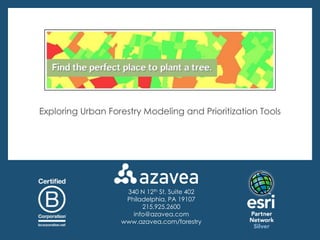
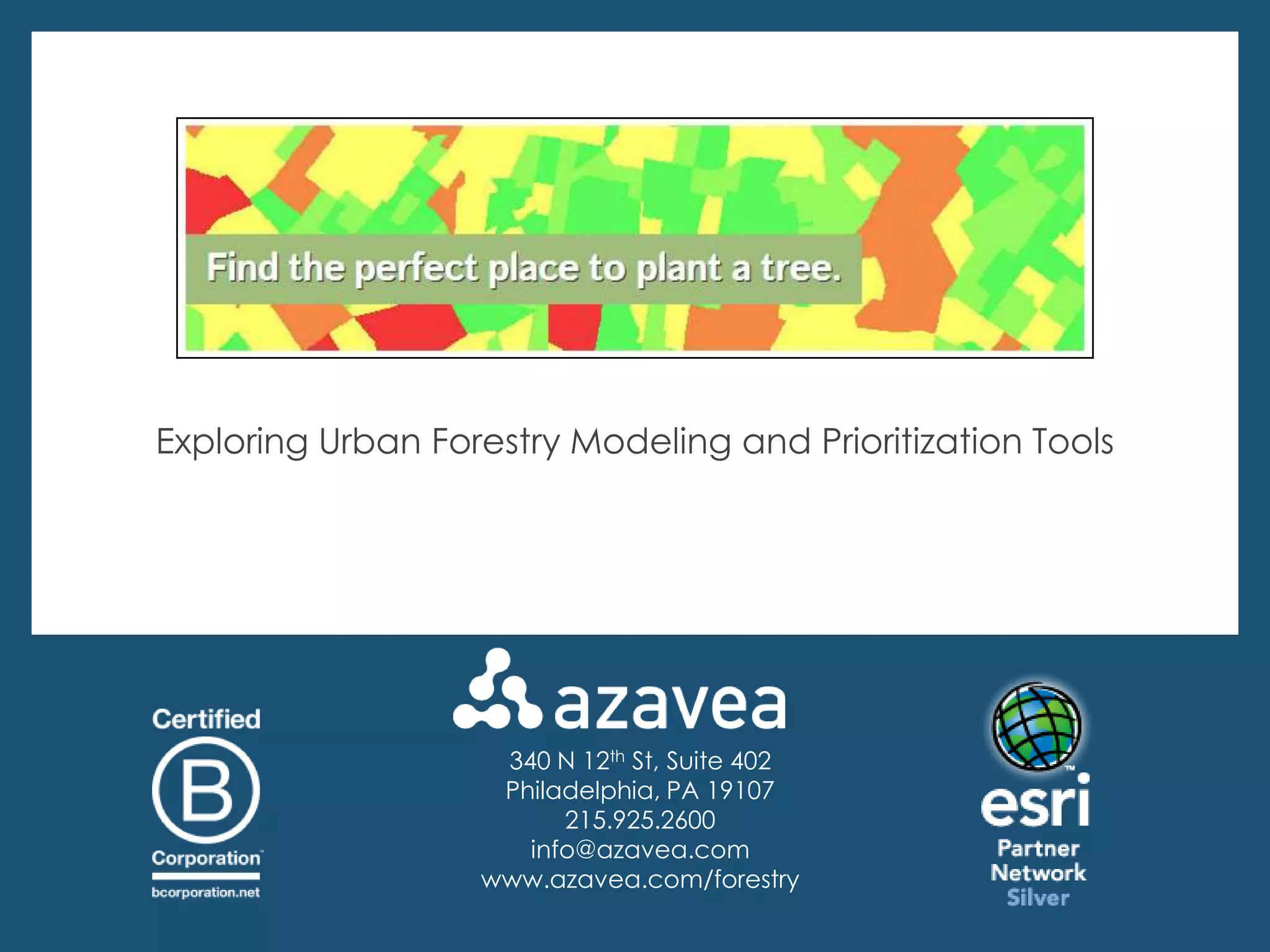
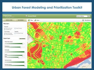
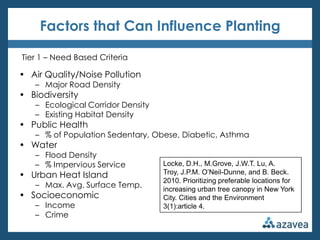
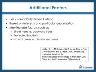
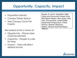
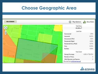
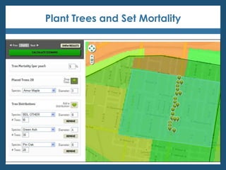
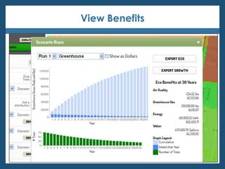
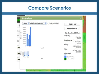
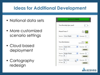
Exploring Urban Forestry Modeling and Prioritization Tools


                    340 N 12th St, Suite 402
                    Philadelphia, PA 19107
                         215.925.2600
                      info@azavea.com
                   www.azavea.com/forestry
About Us


    Deborah Boyer
    Urban Forestry Project Manager
    dboyer@azavea.com
    215.701.7506


   Carissa Brittain
   Software Developer
   cbrittain@azavea.com
   215.701.7716
Agenda

• Azavea Background

• Urban Forest Modeling and Prioritization Toolkit

• Finding Prioritized Planting Locations
   – Research review
   – Identifying key locations

• Modeling Future Benefits
  – Research review
  – Estimating long term impact

• Questions
About Azavea

• Founded in 2000
• 30+ people
• Based in Philadelphia
   – Also Boston & Minneapolis
• Geospatial + web + mobile
   – Software development
   – Spatial analysis services
   – User experience
Research-Driven
   • 10% Research Program
   • Academic Collaboration
B Corporation
   • Pro Bono Program
   • Donate share of profits
   • Projects w/ Social Value
   • Open Source
Azavea and Urban Forestry


     An open source tree data management system
for collaborative, geography enabled urban tree inventory

                 www.opentreemap.org
High Performance Geoprocessing

• GeoTrellis – an open source geographic data processing
  engine

• Breaks big projects into small distributed tasks

• Makes geographic
  analysis really, really fast

• Helps create web-based
  heat maps
How Is It Used?
Urban Forest Modeling and Prioritization Toolkit
Goals
The Main Questions


How do we identify key tree planting locations
based on a variety of factors?


How do we begin to estimate the long term
impacts of trees planted in a certain location?
Urban Forestry Modeling and Prioritization Toolkit


• Funded with a USDA Small Business Innovation Research Grant

• Focuses on identifying prioritized tree planting locations

• Recognizes people have different planting priorities

• Enables users to set adjustable factors in order to create
  customized heat maps

• Calculates the thirty year benefits of trees planted in a certain
  area using growth/mortality rates and iTree
Finding Key Locations
Previous Research
Factors that Can Influence Planting

Tier 1 – Need Based Criteria

• Air Quality/Noise Pollution
   – Major Road Density
• Biodiversity
   – Ecological Corridor Density
   – Existing Habitat Density
• Public Health
   – % of Population Sedentary, Obese, Diabetic, Asthma
• Water
   – Flood Density
   – % Impervious Service          Locke, D.H., M.Grove, J.W.T. Lu, A.
• Urban Heat Island                Troy, J.P.M. O’Neil-Dunne, and B. Beck.
                                   2010. Prioritizing preferable locations for
   – Max. Avg. Surface Temp.       increasing urban tree canopy in New York
• Socioeconomic                    City. Cities and the Environment
   – Income                        3(1):article 4.
   – Crime
Additional Factors

• Tier 2 – Suitability Based Criteria
• Based on interests of a particular organization
• May include factors such as
   – Street trees vs. backyard trees
   – Protected habitats
   – Natural areas vs. developed areas


                         Locke, D.H., M.Grove, J.W.T. Lu, A. Troy, J.P.M.
                         O’Neil-Dunne, and B. Beck. 2010. Prioritizing
                         preferable locations for
                         increasing urban tree canopy in New York City.
                         Cities and the Environment 3(1):article 4.
Opportunity, Capacity, Impact

                                 Nowak, D. and E. Greenfield. 2009.
• Population Density             Urban and Community Forests of the
• Canopy Green Space             Mid-Atlantic Region: New Jersey, New
                                 York, Pennsylvania. United States
• Tree Canopy Cover Per          Department of Agriculture, Forest
  Capita                         Service, Northern Research
                                 Station, General Technical Report
                                 NRS-47.
We looked at this in terms of:
• Opportunity – Places trees
  could be planted
• Capacity – People to care
  for trees
• Impact – Trees will effect
  desired factors
Identifying Locations
Where to get the data?

•   Major streets               • American Community
•   Mass transit routes           Survey data
•   Habitat ranges              • Police crime data
•   Protected lands             • Impervious surface
•   Land cover/tree canopy      • U.S. Geological Survey slope
•   Asthma data                   data
•   Obesity data                • DVRPC Degrees of
                                  Disadvantage info
•   Flood zone maps
                                • Pennsylvania Horticultural
•   Sewershed overflow events     Society TreeTenders’ areas
•   Landsat imagery
Simple and Advanced Models
Let the User Choose the Factor
Additional Map Layers
Customize Map Viewing Options

• Choose opacity

• Show a certain
  percentage of ideal
  locations

• Add more geographic
  boundaries

• Change your basemap
Demo
Modeling Benefits
Previous Research
Growth Rates


Nowak, D. 1994. Chapter 6: Atmospheric Carbon Dioxide
  Reduction by Chicago's Urban Forest. Results of the Chicago
  Urban Forest Climate Project. USDA Forest Service,
  Northeastern Forest Experiment Station, General Technical
  Report NE-186.
Mortality Rates

Philadelphia Street Tree Survival Rates

  Roman, L. 2006. Trends in Street Tree Survival, Philadelphia, PA.
  ScholarlyCommons, University of Pennsylvania.


Average Mortality Based on Land-Use Type, Species, DBH
  Class, and Condition

  Nowak, D, et al. 2004. Tree Mortality Rates and Tree Population
  projections in Baltimore, Maryland, USA. Urban Forestry and
  Urban Greening, vol 2, issue 3, p 139-147.
Ecological Benefits

• i-Tree
    –   Air Quality
    –   Greenhouse Gas
    –   Energy
    –   Water


• Customized for current costs
  in Philadelphia
Estimating Impact
Choose Geographic Area
Plant Trees and Set Mortality
View Benefits
Compare Scenarios
Demo
Future Features
Ideas for Additional Development

• National data sets

• More customized
  scenario settings

• Cloud based
  deployment

• Cartography
  redesign
Questions?
Contact Us


     Deborah Boyer
     Urban Forestry Project Manager
     dboyer@azavea.com
     215.701.7506


    Carissa Brittain
    Software Developer
    cbrittain@azavea.com
    215.701.7716
Exploring Urban Forestry Modeling and Prioritization Tools


                    340 N 12th St, Suite 402
                    Philadelphia, PA 19107
                         215.925.2600
                      info@azavea.com
                   www.azavea.com/forestry

Exploring Urban Forestry Modeling and Prioritization Tools

  • 1.
    Exploring Urban ForestryModeling and Prioritization Tools 340 N 12th St, Suite 402 Philadelphia, PA 19107 215.925.2600 info@azavea.com www.azavea.com/forestry
  • 2.
    About Us Deborah Boyer Urban Forestry Project Manager dboyer@azavea.com 215.701.7506 Carissa Brittain Software Developer cbrittain@azavea.com 215.701.7716
  • 3.
    Agenda • Azavea Background •Urban Forest Modeling and Prioritization Toolkit • Finding Prioritized Planting Locations – Research review – Identifying key locations • Modeling Future Benefits – Research review – Estimating long term impact • Questions
  • 4.
    About Azavea • Foundedin 2000 • 30+ people • Based in Philadelphia – Also Boston & Minneapolis • Geospatial + web + mobile – Software development – Spatial analysis services – User experience
  • 5.
    Research-Driven • 10% Research Program • Academic Collaboration B Corporation • Pro Bono Program • Donate share of profits • Projects w/ Social Value • Open Source
  • 6.
    Azavea and UrbanForestry An open source tree data management system for collaborative, geography enabled urban tree inventory www.opentreemap.org
  • 7.
    High Performance Geoprocessing •GeoTrellis – an open source geographic data processing engine • Breaks big projects into small distributed tasks • Makes geographic analysis really, really fast • Helps create web-based heat maps
  • 8.
    How Is ItUsed?
  • 9.
    Urban Forest Modelingand Prioritization Toolkit
  • 10.
  • 11.
    The Main Questions Howdo we identify key tree planting locations based on a variety of factors? How do we begin to estimate the long term impacts of trees planted in a certain location?
  • 12.
    Urban Forestry Modelingand Prioritization Toolkit • Funded with a USDA Small Business Innovation Research Grant • Focuses on identifying prioritized tree planting locations • Recognizes people have different planting priorities • Enables users to set adjustable factors in order to create customized heat maps • Calculates the thirty year benefits of trees planted in a certain area using growth/mortality rates and iTree
  • 13.
  • 14.
  • 15.
    Factors that CanInfluence Planting Tier 1 – Need Based Criteria • Air Quality/Noise Pollution – Major Road Density • Biodiversity – Ecological Corridor Density – Existing Habitat Density • Public Health – % of Population Sedentary, Obese, Diabetic, Asthma • Water – Flood Density – % Impervious Service Locke, D.H., M.Grove, J.W.T. Lu, A. • Urban Heat Island Troy, J.P.M. O’Neil-Dunne, and B. Beck. 2010. Prioritizing preferable locations for – Max. Avg. Surface Temp. increasing urban tree canopy in New York • Socioeconomic City. Cities and the Environment – Income 3(1):article 4. – Crime
  • 16.
    Additional Factors • Tier2 – Suitability Based Criteria • Based on interests of a particular organization • May include factors such as – Street trees vs. backyard trees – Protected habitats – Natural areas vs. developed areas Locke, D.H., M.Grove, J.W.T. Lu, A. Troy, J.P.M. O’Neil-Dunne, and B. Beck. 2010. Prioritizing preferable locations for increasing urban tree canopy in New York City. Cities and the Environment 3(1):article 4.
  • 17.
    Opportunity, Capacity, Impact Nowak, D. and E. Greenfield. 2009. • Population Density Urban and Community Forests of the • Canopy Green Space Mid-Atlantic Region: New Jersey, New York, Pennsylvania. United States • Tree Canopy Cover Per Department of Agriculture, Forest Capita Service, Northern Research Station, General Technical Report NRS-47. We looked at this in terms of: • Opportunity – Places trees could be planted • Capacity – People to care for trees • Impact – Trees will effect desired factors
  • 18.
  • 19.
    Where to getthe data? • Major streets • American Community • Mass transit routes Survey data • Habitat ranges • Police crime data • Protected lands • Impervious surface • Land cover/tree canopy • U.S. Geological Survey slope • Asthma data data • Obesity data • DVRPC Degrees of Disadvantage info • Flood zone maps • Pennsylvania Horticultural • Sewershed overflow events Society TreeTenders’ areas • Landsat imagery
  • 20.
  • 21.
    Let the UserChoose the Factor
  • 22.
  • 23.
    Customize Map ViewingOptions • Choose opacity • Show a certain percentage of ideal locations • Add more geographic boundaries • Change your basemap
  • 24.
  • 25.
  • 26.
  • 27.
    Growth Rates Nowak, D.1994. Chapter 6: Atmospheric Carbon Dioxide Reduction by Chicago's Urban Forest. Results of the Chicago Urban Forest Climate Project. USDA Forest Service, Northeastern Forest Experiment Station, General Technical Report NE-186.
  • 28.
    Mortality Rates Philadelphia StreetTree Survival Rates Roman, L. 2006. Trends in Street Tree Survival, Philadelphia, PA. ScholarlyCommons, University of Pennsylvania. Average Mortality Based on Land-Use Type, Species, DBH Class, and Condition Nowak, D, et al. 2004. Tree Mortality Rates and Tree Population projections in Baltimore, Maryland, USA. Urban Forestry and Urban Greening, vol 2, issue 3, p 139-147.
  • 29.
    Ecological Benefits • i-Tree – Air Quality – Greenhouse Gas – Energy – Water • Customized for current costs in Philadelphia
  • 30.
  • 31.
  • 32.
    Plant Trees andSet Mortality
  • 33.
  • 34.
  • 35.
  • 36.
  • 37.
    Ideas for AdditionalDevelopment • National data sets • More customized scenario settings • Cloud based deployment • Cartography redesign
  • 38.
  • 39.
    Contact Us Deborah Boyer Urban Forestry Project Manager dboyer@azavea.com 215.701.7506 Carissa Brittain Software Developer cbrittain@azavea.com 215.701.7716
  • 40.
    Exploring Urban ForestryModeling and Prioritization Tools 340 N 12th St, Suite 402 Philadelphia, PA 19107 215.925.2600 info@azavea.com www.azavea.com/forestry