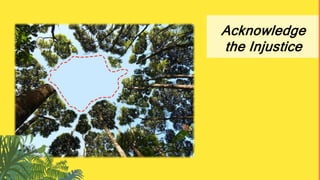
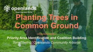
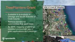
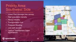
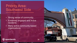
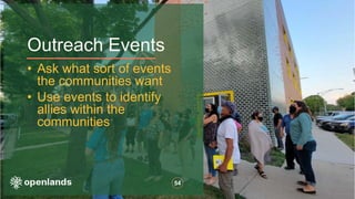
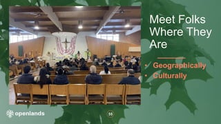
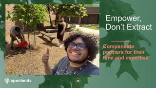
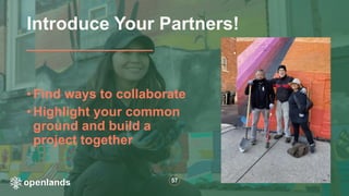
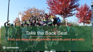
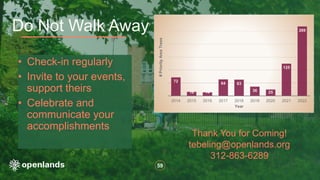
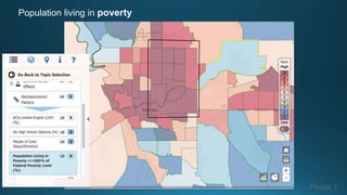
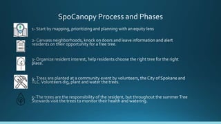
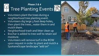
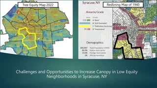
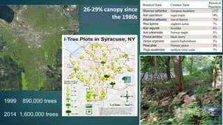
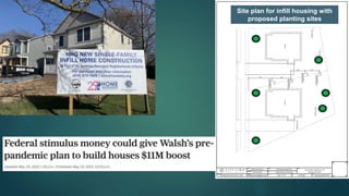
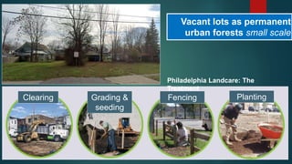
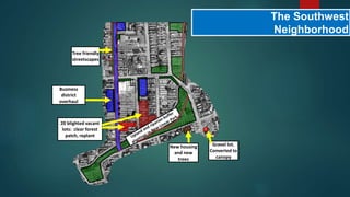
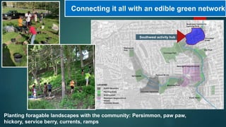
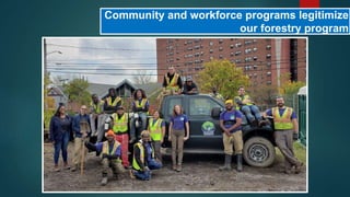
Trees as a measure of equity
Median Income and Canopy Coverage
Population living in poverty
Phase 1
redlining
Phase 1
Phase 1
SpoCanopy’s goal is to equitably increase
urban canopy by planting street trees in low
canopy, low-income neighborhoods
Street Trees - Class II
SpoCanopy Process and Phases
Canvassing, Phase 2
James, TLC’s outreach intern,
canvassing neighborhoods 2020
Phase 3 & 4
Phase 5
Challenges and Opportunities to Increase Canopy in Low Equity
Neighborhoods in Syracuse, NY
Tree Equity Map 2022 Redlining Map of 1940
2020 Urban Forest Master Plan
Adopted April 27, 2022!!
1. Increase canopy 7%,
start in low equity areas
2. Improve forest health
and resiliency
3. Create a culture of
urban forest
stewardship
Master Plan Implementation
AMERICAN RESCUE PLAN: $2 million for urban forests
• Plant 3,600 trees, focus on low canopy areas
• Improve site conditions
• Pruning 4,500 young trees
Budget increases:
Tree-friendly streetscapes: $470K
Natural areas restoration: $130K
New Forestry Technician position
3 YEARS to spend funds and transition to next step!
GAINS
LOSSES
1% canopy loss from 2013 to
2019
City owned vacant lot portfolio:
• 1,000+ parcels and growing
• 5,749 acres in city ownership
26-29% canopy since
the 1980s
1999 890,000 trees
2014 1,600,000 trees
113 trees per mile 52 trees per mile
31% canopy cover
28% canopy cover
SEDGWICK BRIGHTON
S Salina Business District before
Turning down the heat in business
districts
After
Tree Friendly Streetscapes
Asphalt removal, trenching and planting (a week from now)
CU Soil used as tunnel for roots
Site plan for infill housing with
proposed planting sites
Vacant lots as permanent
urban forests small scale
Clearing Grading &
seeding
Fencing Planting
Philadelphia Landcare: The
Treatment
The Southwest
Neighborhood
Tree friendly
streetscapes
New housing
and new
trees
20 blighted vacant
lots: clear forest
patch, replant
Business
district
overhaul
Gravel lot.
Converted to
canopy
Connecting it all with an edible green network
Planting foragable landscapes with the community: Persimmon, paw paw,
hickory, service berry, currents, ramps
Southwest activity hub
Community and workforce programs legitimize
our forestry program
From I-81 to a
Community Grid
Steve Harris, City Arborist
Syracuse Parks
sharris@syrgov.net (315) 956-3081
A Vision of Tree Equity
Dr. Heather McMillen
State of Hawai‘i
Forestry & Wildlife
Insights from Hawaiʻi
Co-Authors: Miranda Hutten, Pōhaku Kepler, Brayden Aki
Photo Credit: KPCW
Credit: EarthDefine LLC, US Forest Service, National Oceanic and Atmospheric Administration, HI Division of Forestry
and Wildlife. 2021. Hawaii High Resolution 1m Tree Canopy Map [ESRI file geodatabase raster format], 2009-2020.
Hawai‘i Tree Canopy layer created by EarthDefine based on Maxar VIVID imagery and LiDAR data where available
Household Income
(U.S. Dollars)
25k - 57k
57k - 76k
76k - 92k
92k -110k
110k -162k
Tree Canopy
and Schools
1/2 mile radius
around schools
shadier, safer
walks to school
Hawaiʻi is
Diverse
Cultures
Biology
Geography
Tagalog
Ilocano
Japanese
Hawaiian
Other
Samoan
Korean
Chinese
Spanish
Languages Other Than English Spoken at Home
Invasive
Species
Photo Credit: Jim Denny Photo Credit: PF Bentley/Civil Beat
Endemic
Species
Ōhiʻa Lehua
Albizia
Diverse
Biogeography
Waiʻanae
22 inches
Maunawili
73 inches
Seattle
37 inches
Acknowledge
the Injustice
Enduring
Legacies
1893
Illegal
Overthrow of
the Hawaiian
Kingdom
United States Public Law: 103-150
Photo Credit: Ed Greevy, Speech on the Beach, 1993
Our Vision of
Tree Equity
Indigenous
Stewardship and
Kinship
Photo Credit: Elyse Butler
Food
Medicine
Carving
Weaving
Building
Hula
Family
Ancestors
Gods
Biocultural
Continuity
Photo Credit: Hoʻoulu ʻĀina
Food
Sovereignty
90% food
is imported
48% families
food insecure
Photo Credit: NiU NOW!
Achieving
Tree Equity
Biocultural
Continuity
Food Sovereignty
Restoring
Relationships
Mahalo!
Thank You!
heather.l.mcmillen@hawaii.gov
w. kaulunani.org
ig. @kaulunani
Planting Trees in
Common Ground
Priority Area Identification and Coalition Building
Tom Ebeling, Openlands Community Arborist
47
• Providers and Creators of access to nature for ALL
• Conveners and Connectors of communities and
organizations
Openlands:
TreePlanters Grant
48
• Available to everybody in
Chicago and South Suburbs of
Cook County
• Remove barriers for
communities that want trees.
• By 2018, mapping of plantings
revealed pronounced gap in
grant applications and plantings.
Priority Area:
Southwest Side
49
• Lower than average tree canopy
• High population density
• Heavy industry
• Transportation hub
• Frequent flooding
• Low park access
• Lack of TreePlanters Grant
applications
Priority Area:
Southwest Side
50
• Strong sense of community
• Extremely engaged and active
residents
• Many active community-based
organizations
51
Make Specific Goals
Walk the Walk
Build Capacity to
meet those goals
Engagement Techniques
52
Do not attempt to
reinvent the wheel
Find others seeking to provide resources;
Support them!
Do not assume you are
the only ones interested
in trees
Engagement Techniques
53
Tap in to strong, existing
communities
Outreach Events
54
• Ask what sort of events
the communities want
• Use events to identify
allies within the
communities
55
• Geographically
• Culturally
Meet Folks
Where They
Are
56
Compensate
partners for their
time and expertise
Empower,
Don’t Extract
57
• Find ways to collaborate
• Highlight your common
ground and build a
project together
Introduce Your Partners!
Take the Back Seat
Find out where your partners want to plant and why.
58
59
• Check-in regularly
• Invite to your events,
support theirs
• Celebrate and
communicate your
accomplishments
Do Not Walk Away
72
16 14
64 63
36 25
125
269
2014 2015 2016 2017 2018 2019 2020 2021 2022
#
Priority
Area
Trees
Year
Thank You for Coming!
tebeling@openlands.org
312-863-6289
Lightning Round: Environmental Justice

Lightning Round: Environmental Justice

Editor's Notes

  • #2 Introduce yo’ self
  • #4 Rich Americans enjoy more greenery in their environment compared with people in lower-income communities. This trend is present in cities across the country.
  • #5 This a map published by the Washinton Departmet of Health shows the % of people living in federal poverty. There is a clear concentration in NE and East Central of Spokane Racially diverse The Washington Environmental Health Disparities Map is an interactive mapping tool that compares communities across our state for environmental health disparities. The map shows pollution measures such as diesel emissions and ozone, as well as proximity to hazardous waste sites. In addition, it displays measures like poverty and cardiovascular disease. The map also provides new and rigorous insights into where public investments can be prioritized to buffer environmental health impacts on Washington's communities, so that everyone can benefit from clean air, clean water, and a healthy environment.
  • #6 Why are some areas of Spokane so drastically different? In the United States, redlining is the systematic denial of various services to residents of specific, often racially associated, neighborhoods or communities, either explicitly or through the selective raising of prices Systemic denial of services and resources There is a correlation between areas that were redlined and neighborhoods that now have less trees low canopy coverage
  • #7 Notice how, generally, the red and yellow areas align with the lower canopy coverage areas? Notice how NE and EC Spokane in particular had concentrations of redlined areas? To bridge a canopy/ equity gap, we are focusing our plantings in NE Spokane .
  • #8 Diving into the NE neighborhoods a little more . There is a clear need to plant in these areas.
  • #9 To bridge a canopy/ equity gap, we are focusing our plantings in NE Spokane . Planting trees is one way to invest in these historically underserved communities. Remember all of the benefits of trees discussed earlier? Canopy coverage can be an indicator of Planting trees can be an environmental justice issue and is one step in bridging the equity gap
  • #10 All trees have value, but Spocanopy is planting street trees specifically Street trees are trees planted between the sidewalk and the street “Right tree, right place” for buckling sidewalk
  • #11 SpoCanopy’s goal is to do just that. TO plant trees in low-income, low canopy neighorboods by and with residents and community volunteers. Phases : Where is there low canopy? Do residents want a tree? They get to choose what kind of tree. Volunteers and neighbors plant the trees, and then the resident cares fo the tree for its lifetime.
  • #14 Redeisents cares for the tree
  • #17 I am going to talk to you about how we are trying to increase canopy in our historically redlined neighborhoods. The photos you will see in this presentation are in those neighborhoods. The boundaries are shown in these surface temp and redlining maps. The push to increase canopy and to focus on tree equity came out of our urban forest master planning process and is taking place as Syracuse is aggressively pursuing initiatives to combat some of the worst poverty in the nation.
  • #18 Public input for this process garnered feedback from 1500 residents through public meetings and surveys and is crystallized into 3 primary goals. Our goal to increase canopy 7% will be met by planting 70,000 trees in 20 years including 1,500 on public spaces and 2,000 on private. This talk is primarily about the public space realm.
  • #19 Our Mayor who is very pro-tree allocated $2 million in stimulus to kick start implementation but he also increased budgets and staff for the Forestry Division. Following the recommendations of the master plan we saw increases for streetscapes, pruning and natural areas management. Additionally, we added a staff position. We have three years to meet the ARPA goals. There are a lot of challenges to increasing canopy and outpacing removals
  • #20 including streets not designed for trees, canopy loss from sidewalk repairs, housing demos and land development. The latter speaks to the weakness of our ordinance which has not been changed since its establishment in 1965. It is time to modernize it with tree protection and mitigation measures for tree loss. Now that our community has been through the master planning process they are ready for the conversation about new tree laws.
  • #21 Another concern is the condition of canopy that does exist. Canopy cover has been relatively stable since the mid 80s but the number of trees have nearly doubled. A 900% increase in buckthorn and tree of heaven drive this growth. Invasives colonize vacant lands where low quality backyard trees remain. They can become blighted with trash and create a negative attitude towards trees. When we are ordered to clear, we keep healthy trees but most or not.
  • #22 The reality in our redlined areas is that much of this urban forest needs rebuilt like our housing stock. Consider Sedgwick and Brighton, one wealthy, one poor. Similar canopy. Roads in Sedgwick are highlighted to illustrate that it has nearly double the tree density of Brighton. With more trees in decline, more invasives and fewer trees shading houses and roads the bigger urban forest of brighton is providing fewer ecosystem services.
  • #23 Our solution to these challenges starts with Increasing canopy in low tree equity business districts by creating space for trees. This business district went through a streetscape improvement in 2009 but with no trees in the design. Fortunately, the county needed to stop storm water from entering their CSO. Their design used a combination of silva cells and structural soils to create space for roots while capturing stormwater. Each trees has 800 cubic feet of rooting volume.
  • #24 We do a lot of low-tech streetscape interventions working with the sidewalk engineer and transportation planner. Upper right is my colleague Kim in a pit 3 feet deep and 10 feet long that will be filled with Structural Soil so that roots can pass under the sidewalk being installed. Root tunnels are important since sidewalks are going from 4 to 5 feet wide. We are also removing asphalt in our right of way then we trench, fill with soil and plant.
  • #25 The Department of Neighborhood Development oversees the mayor’s signature program to revitalize neighborhoods through infill construction of Quality, affordable housing and apartments. They will be built in high concentrations in on blocks near recent investment and community assets. Forestry will inspect sites prior to building to remove hazard trees and to identify tree protection zones for healthy trees. Planners are identifying vacant lots to plant permanent urban forest.
  • #26 The intervention will be an easy to maintain landscape of grass and trees that ensures visibility and creates shade, an approach modeled after the Philadelphia Landcare Program. We vacant lots can help us achieve 30% canopy neighborhoods and provide people with safe functional greenspace within walking distance. City Hall likes likes the blight reduction aspect and told us to think big come budget time.
  • #27 This slide shows all interventions I described coming together in The Southwest Neighborhood. A neglected business district shown in blue will see 10 mill in investment from the state including a tree friendly streetscape and building rehabs starting 2024. To build on this upcoming investment, the city will seize 20 lots in red and clear and replant the Landscare way in order to connect the business corridor with the new and beloved creekwalk extension south of it.
  • #28 This year, along the creekwalk, the Syracuse Urban Food Forest Project planted over 200 edible trees and shrubs with school kids, volunteers and neighborhors. SUFFP is a partnership between the SUNY College of Environmental Science and Forestry, the Food Studies Program at Syracuse University and two youth programs involved in forestry and gardening. The intent is to connect greenspace using vacant lots while passing through neighborhoods.
  • #29 We embrace the idea that equity is not just about where we plant but who plants. That is why the Parks department contracts with the Ononaga Earth Corps to plant and prune lots of trees and restore our natural areas. I feel this investment legitimizes our programs and gives us political capital. OEC is the heart and soul of our community forestry program as they come from the neighborhood we are trying to impact and provide the connections and feedback we need to stay on the right course for the neighborhood.
  • #30 In the near future are three once in a generation events that could have a profound impact on tree equity. I-81 is coming down and proposed to be replaced with a tree lined community grid that is pedestrian friendly. Next to it the city’s largest public housing community will be rebuilt. Once the social and economic heart of the Black community, this neighborhood was decimated by highway construction under urban renewal. The vision for the new neighborhood has trees and greenspace front and center.
  • #32 30.11.2022
  • #36 Chart represents 25.4% of Hawaii’s population
  • #45 30.11.2022