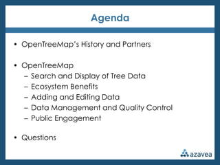
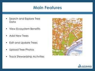
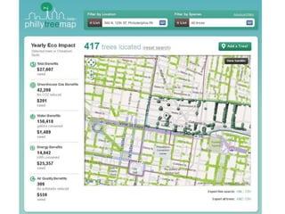
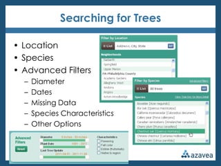
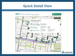
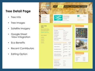
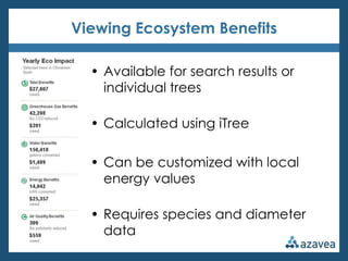
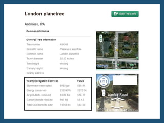
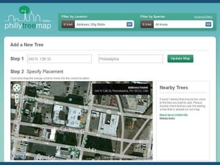
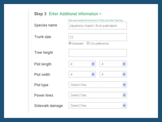
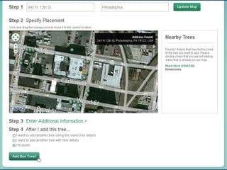
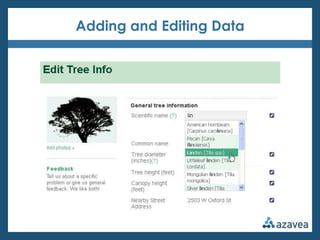
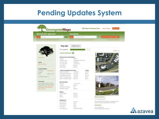
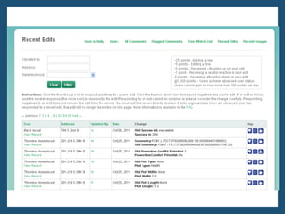
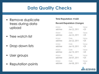
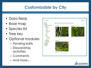
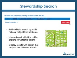
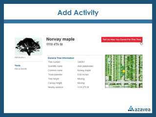
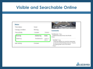
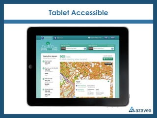
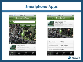
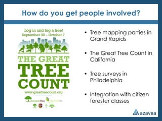
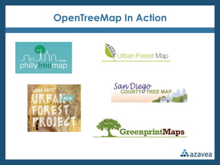
Tree Technology – Part V: Urban Forest Mapping


                340 N 12th St, Suite 402
                Philadelphia, PA 19107
                     215.925.2600
                  info@azavea.com
            www.azavea.com/opentreemap
Agenda

• OpenTreeMap’s History and Partners

• OpenTreeMap
  – Search and Display of Tree Data
  – Ecosystem Benefits
  – Adding and Editing Data
  – Data Management and Quality Control
  – Public Engagement

• Questions
An open source tree data management system
for collaborative, geography enabled urban tree inventory
Main Features

• Search and Explore Tree
  Data

• View Ecosystem Benefits

• Add New Trees

• Edit and Update Trees

• Upload Tree Photos

• Track Stewardship Activities
Partners and Funders
About Azavea

• Founded in 2000
• B Corporation
• 30+ people
• Based in Philadelphia
• Geospatial + web + mobile
   – Software development
   – Spatial analysis services
   – User experience
OpenTreeMap History

• Urban Forest Map

• USDA Small Business Innovation Research (SBIR) Grant Phase 1

• PhillyTreeMap and
  Greenprint Maps

• Released as open
  source project

• USDA Phase 2 Grant

• More maps!!!
Open Source? What does that mean?

• No license fee

• Anyone can download and contribute to the code

• Maintained by a community of users

• New features are added back into the code for
  everyone to use

• Accessible at www.opentreemap.org
Search and Display
Searching for Trees

• Location
• Species
• Advanced Filters
  –   Diameter
  –   Dates
  –   Missing Data
  –   Species Characteristics
  –   Other Options
Quick Detail View
Tree Detail Page
 • Tree Info

 • Tree Images

 • Satellite Imagery

 • Google Street
   View Integration

 • Eco Benefits

 • Recent Contributors

 • Editing Option
Calculate Eco Benefits
Viewing Ecosystem Benefits

  • Available for search results or
    individual trees

  • Calculated using iTree

  • Can be customized with local
    energy values

  • Requires species and diameter
    data
Adding and Editing Data
Data Quality
Pending Updates System
Data Quality Checks

• Remove duplicate
  trees during data
  upload

• Tree watch list

• Drop down lists

• User groups

• Reputation points
Administrative Management

• Bulk data upload

• Review comments and
  uploaded images

• View recent activity
  and edits

• Manage user groups

• Manage tree watch list
Public Engagement
Customizable by City

•   Data fields
•   Base map
•   Species list
•   Tree key
•   Optional modules
    – Pending edits
    – Stewardship
      activities
    – Comments
    – And more…
Stewardship Search


• Add ability to search by public
  actions, not just tree attributes

• Use settings that let the public
  explore stewardship actions

• Display results with design that
  emphasizes action or inaction
Add Activity
Visible and Searchable Online
Tablet Accessible
Smartphone Apps
How do you get people involved?

                • Tree mapping parties in
                  Grand Rapids

                • The Great Tree Count in
                  California

                • Tree surveys in
                  Philadelphia

                • Integration with citizen
                  forester classes
OpenTreeMap In Action
Deborah Boyer
    OpenTreeMap Project Manager
    dboyer@azavea.com
    215.701.7506
    www.opentreemap.org
    Twitter: OpenTreeMap


Questions?
Tree Technology – Part V: Urban Forest Mapping


                340 N 12th St, Suite 402
                Philadelphia, PA 19107
                     215.925.2600
                  info@azavea.com
            www.azavea.com/opentreemap

OpenTreeMap Overview

  • 1.
    Tree Technology –Part V: Urban Forest Mapping 340 N 12th St, Suite 402 Philadelphia, PA 19107 215.925.2600 info@azavea.com www.azavea.com/opentreemap
  • 2.
    Agenda • OpenTreeMap’s Historyand Partners • OpenTreeMap – Search and Display of Tree Data – Ecosystem Benefits – Adding and Editing Data – Data Management and Quality Control – Public Engagement • Questions
  • 3.
    An open sourcetree data management system for collaborative, geography enabled urban tree inventory
  • 4.
    Main Features • Searchand Explore Tree Data • View Ecosystem Benefits • Add New Trees • Edit and Update Trees • Upload Tree Photos • Track Stewardship Activities
  • 5.
  • 6.
    About Azavea • Foundedin 2000 • B Corporation • 30+ people • Based in Philadelphia • Geospatial + web + mobile – Software development – Spatial analysis services – User experience
  • 7.
    OpenTreeMap History • UrbanForest Map • USDA Small Business Innovation Research (SBIR) Grant Phase 1 • PhillyTreeMap and Greenprint Maps • Released as open source project • USDA Phase 2 Grant • More maps!!!
  • 8.
    Open Source? Whatdoes that mean? • No license fee • Anyone can download and contribute to the code • Maintained by a community of users • New features are added back into the code for everyone to use • Accessible at www.opentreemap.org
  • 9.
  • 11.
    Searching for Trees •Location • Species • Advanced Filters – Diameter – Dates – Missing Data – Species Characteristics – Other Options
  • 12.
  • 13.
    Tree Detail Page • Tree Info • Tree Images • Satellite Imagery • Google Street View Integration • Eco Benefits • Recent Contributors • Editing Option
  • 14.
  • 15.
    Viewing Ecosystem Benefits • Available for search results or individual trees • Calculated using iTree • Can be customized with local energy values • Requires species and diameter data
  • 17.
  • 21.
  • 22.
  • 23.
  • 25.
    Data Quality Checks •Remove duplicate trees during data upload • Tree watch list • Drop down lists • User groups • Reputation points
  • 26.
    Administrative Management • Bulkdata upload • Review comments and uploaded images • View recent activity and edits • Manage user groups • Manage tree watch list
  • 27.
  • 28.
    Customizable by City • Data fields • Base map • Species list • Tree key • Optional modules – Pending edits – Stewardship activities – Comments – And more…
  • 29.
    Stewardship Search • Addability to search by public actions, not just tree attributes • Use settings that let the public explore stewardship actions • Display results with design that emphasizes action or inaction
  • 30.
  • 31.
  • 32.
  • 33.
  • 34.
    How do youget people involved? • Tree mapping parties in Grand Rapids • The Great Tree Count in California • Tree surveys in Philadelphia • Integration with citizen forester classes
  • 35.
  • 36.
    Deborah Boyer OpenTreeMap Project Manager dboyer@azavea.com 215.701.7506 www.opentreemap.org Twitter: OpenTreeMap Questions?
  • 37.
    Tree Technology –Part V: Urban Forest Mapping 340 N 12th St, Suite 402 Philadelphia, PA 19107 215.925.2600 info@azavea.com www.azavea.com/opentreemap