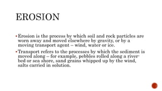
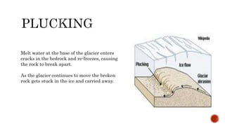
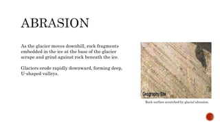
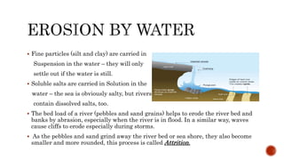
MUHAMMAD AHMAD
(FA18-CVE-020)
Presented To: Sir Yusuf Mushtaq
CIVIL ENGINEERING DEPARTMENT
COMSATS UNIVERSITY ISLAMABAD,SAHIWAL
Erosion is the process by which soil and rock particles are
worn away and moved elsewhere by gravity, or by a
moving transport agent – wind, water or ice.
Transport refers to the processes by which the sediment is
moved along – for example, pebbles rolled along a river-
bed or sea shore, sand grains whipped up by the wind,
salts carried in solution.
Erosion involves removal of solid
material by a transporting agent.
Weathering is the breakdown of rock
into fragments at the Earth’s
surface. No movement is involved in
weathering.
 The complete series of changes or stages through which a landmass
passes from the inception of erosion on a newly uplifted or exposed
surface through its dissection into mountains and valleys to the final
stage when it is worn down to the level of the sea or to some other
base level.
 The cycle is usually subdivided into youthful, mature, and old-age
stages. One type or many types of erosion may be involved, and the
landforms produced and destroyed depend to a large extent on the
climate, geographic situation, and geologic structure of the
landmass.
 It is also known as Cycle of Denudation, Geographic Cycle and
Geomorphic Cycle.
Gravity and Mass Wasting
Erosion by Wind
Erosion by Ice
Erosion by Water
Mass–wasting is the down-slope movement of loose rock and soil due to
gravity. Whilst processes such as soil creep are very slow, landslides can be
very sudden, and may cause loss of life.
Mass-wasting is often aided by water, so landslides and mudflows
frequently occur after heavy rain.
EXAMPLES :
1. Soil Creep
2. Rock-Falls
3. Land-Slips
4. Mudflows
Wind erosion and transport is a serious environmental problem
in the driest parts of the world, removing soil from farmland
and covering whole towns with sand and dust.
A strong breeze (wind speed 20 km/h) can easily pick up dry
dust and fine sand. The lightest particles are swirled up into the
air and carried in suspension for hundreds of kilometres, whilst
sand grains bounce along the surface by saltation. Small pebbles
can be moved along with the sand, a process called creep.
Wind rock Australia Carved By Wind Blown Sand Approaching sandstorm in a dust desert
A glacier is a river of ice formed from compacted snow. They
are most common in the Polar regions (e.g.Antarctica) and
in mountain regions like the Alps and Himalayas.
Glaciers move slowly down valleys (at speeds up to a few
metres per day), but have enormous erosive power. Glaciers
erode the surface of the Earth in two ways:
1. Plucking
2. Abrasion
Melt water at the base of the glacier enters
cracks in the bedrock and re-freezes, causing
the rock to break apart.
As the glacier continues to move the broken
rock gets stuck in the ice and carried away.
As the glacier moves downhill, rock fragments
embedded in the ice at the base of the glacier
scrape and grind against rock beneath the ice.
Glaciers erode rapidly downward, forming deep,
U-shaped valleys.
Rock surface scratched by glacial abrasion.
Around the world, moving water picks up and transports
millions of tons of sediment every day, along rivers, coasts,
and even in the deep oceans.
Sediment, whether picked up by flowing water or by waves,
is moved along in one of four ways:
Traction is the rolling or dragging of large grains along a
river bed or shore, aided by the push of the smaller grains
(below).
Saltation is the bouncing of sand grains as they are picked
up, carried along, and dropped repeatedly by flowing
water.
 Fine particles (silt and clay) are carried in
Suspension in the water – they will only
settle out if the water is still.
 Soluble salts are carried in Solution in the
water – the sea is obviously salty, but rivers
contain dissolved salts, too.
 The bed load of a river (pebbles and sand grains) helps to erode the river bed and
banks by abrasion, especially when the river is in flood. In a similar way, waves
cause cliffs to erode especially during storms.
 As the pebbles and sand grind away the river bed or sea shore, they also become
smaller and more rounded, this process is called Attrition.
“A landform is a natural
feature of the solid surface of the
Earth or other planetary body.
Landforms together make up a given
terrain, and their arrangement in the
landscape is known as topography”.
 Landforms are the natural features and shapes existent on the face
of the earth. Landforms possess many different physical
characteristics and are spread out throughout the planet.
 The physical features of landforms include slope, elevation, rock
exposure, stratification and rock type.
 Oceans and continents illustrate the largest grouping of landforms.
They are further subcategorized into many different landforms
based on their physical features and shapes.
 Examples of distinctive landforms include;
1. Mountains and Valleys
2. Plateaus and Glaciers
3. Hills, Loess and Deserts
4. Shorelines, and Plains
Features such as volcanoes, lakes, rivers, mid-ocean ridges, and the
great ocean basins are also part of landform feature.
@ahmed_decentt

Erosion and Landforms

  • 1.
    MUHAMMAD AHMAD (FA18-CVE-020) Presented To:Sir Yusuf Mushtaq CIVIL ENGINEERING DEPARTMENT COMSATS UNIVERSITY ISLAMABAD,SAHIWAL
  • 4.
    Erosion is theprocess by which soil and rock particles are worn away and moved elsewhere by gravity, or by a moving transport agent – wind, water or ice. Transport refers to the processes by which the sediment is moved along – for example, pebbles rolled along a river- bed or sea shore, sand grains whipped up by the wind, salts carried in solution.
  • 6.
    Erosion involves removalof solid material by a transporting agent. Weathering is the breakdown of rock into fragments at the Earth’s surface. No movement is involved in weathering.
  • 8.
     The completeseries of changes or stages through which a landmass passes from the inception of erosion on a newly uplifted or exposed surface through its dissection into mountains and valleys to the final stage when it is worn down to the level of the sea or to some other base level.  The cycle is usually subdivided into youthful, mature, and old-age stages. One type or many types of erosion may be involved, and the landforms produced and destroyed depend to a large extent on the climate, geographic situation, and geologic structure of the landmass.  It is also known as Cycle of Denudation, Geographic Cycle and Geomorphic Cycle.
  • 10.
    Gravity and MassWasting Erosion by Wind Erosion by Ice Erosion by Water
  • 11.
    Mass–wasting is thedown-slope movement of loose rock and soil due to gravity. Whilst processes such as soil creep are very slow, landslides can be very sudden, and may cause loss of life. Mass-wasting is often aided by water, so landslides and mudflows frequently occur after heavy rain. EXAMPLES : 1. Soil Creep 2. Rock-Falls 3. Land-Slips 4. Mudflows
  • 12.
    Wind erosion andtransport is a serious environmental problem in the driest parts of the world, removing soil from farmland and covering whole towns with sand and dust. A strong breeze (wind speed 20 km/h) can easily pick up dry dust and fine sand. The lightest particles are swirled up into the air and carried in suspension for hundreds of kilometres, whilst sand grains bounce along the surface by saltation. Small pebbles can be moved along with the sand, a process called creep. Wind rock Australia Carved By Wind Blown Sand Approaching sandstorm in a dust desert
  • 13.
    A glacier isa river of ice formed from compacted snow. They are most common in the Polar regions (e.g.Antarctica) and in mountain regions like the Alps and Himalayas. Glaciers move slowly down valleys (at speeds up to a few metres per day), but have enormous erosive power. Glaciers erode the surface of the Earth in two ways: 1. Plucking 2. Abrasion
  • 14.
    Melt water atthe base of the glacier enters cracks in the bedrock and re-freezes, causing the rock to break apart. As the glacier continues to move the broken rock gets stuck in the ice and carried away.
  • 15.
    As the glaciermoves downhill, rock fragments embedded in the ice at the base of the glacier scrape and grind against rock beneath the ice. Glaciers erode rapidly downward, forming deep, U-shaped valleys. Rock surface scratched by glacial abrasion.
  • 16.
    Around the world,moving water picks up and transports millions of tons of sediment every day, along rivers, coasts, and even in the deep oceans. Sediment, whether picked up by flowing water or by waves, is moved along in one of four ways: Traction is the rolling or dragging of large grains along a river bed or shore, aided by the push of the smaller grains (below). Saltation is the bouncing of sand grains as they are picked up, carried along, and dropped repeatedly by flowing water.
  • 17.
     Fine particles(silt and clay) are carried in Suspension in the water – they will only settle out if the water is still.  Soluble salts are carried in Solution in the water – the sea is obviously salty, but rivers contain dissolved salts, too.  The bed load of a river (pebbles and sand grains) helps to erode the river bed and banks by abrasion, especially when the river is in flood. In a similar way, waves cause cliffs to erode especially during storms.  As the pebbles and sand grind away the river bed or sea shore, they also become smaller and more rounded, this process is called Attrition.
  • 20.
    “A landform isa natural feature of the solid surface of the Earth or other planetary body. Landforms together make up a given terrain, and their arrangement in the landscape is known as topography”.
  • 21.
     Landforms arethe natural features and shapes existent on the face of the earth. Landforms possess many different physical characteristics and are spread out throughout the planet.  The physical features of landforms include slope, elevation, rock exposure, stratification and rock type.  Oceans and continents illustrate the largest grouping of landforms. They are further subcategorized into many different landforms based on their physical features and shapes.  Examples of distinctive landforms include; 1. Mountains and Valleys 2. Plateaus and Glaciers 3. Hills, Loess and Deserts 4. Shorelines, and Plains Features such as volcanoes, lakes, rivers, mid-ocean ridges, and the great ocean basins are also part of landform feature.
  • 22.