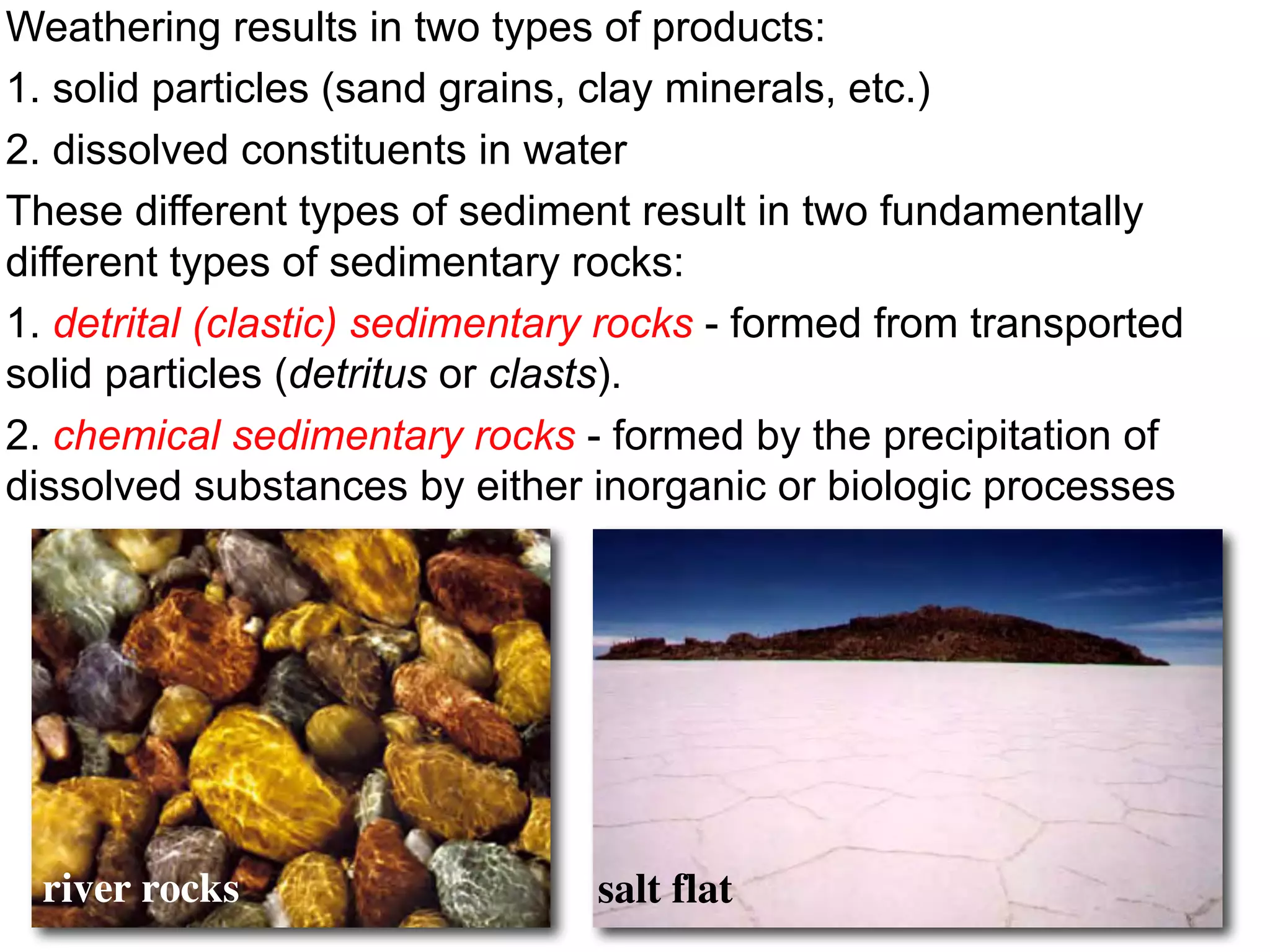
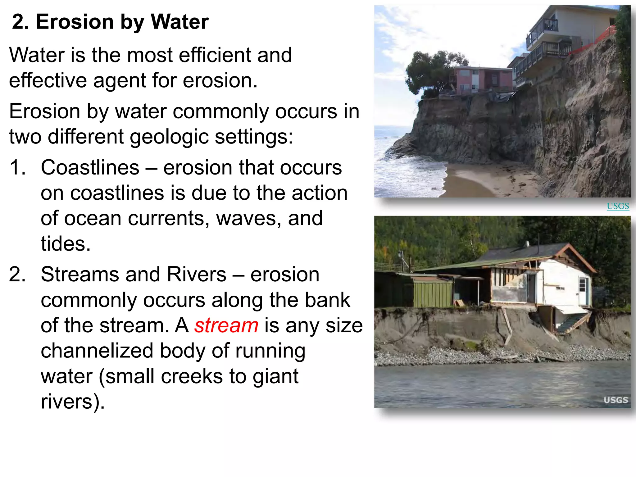
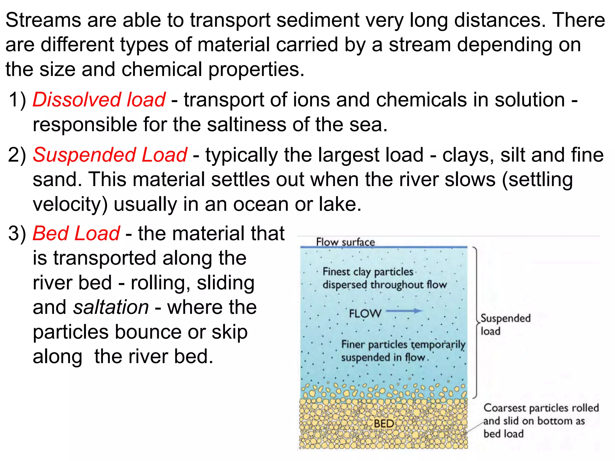
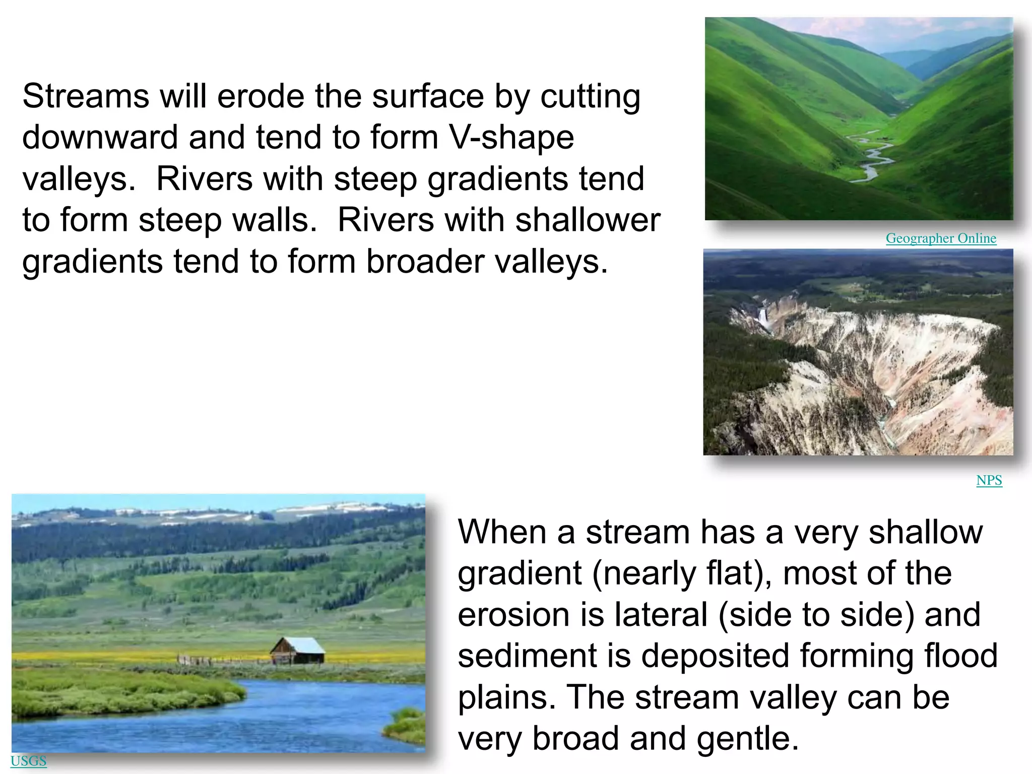
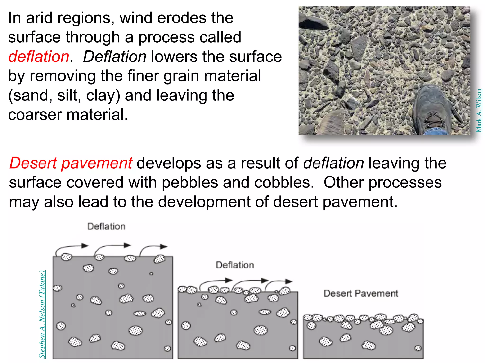
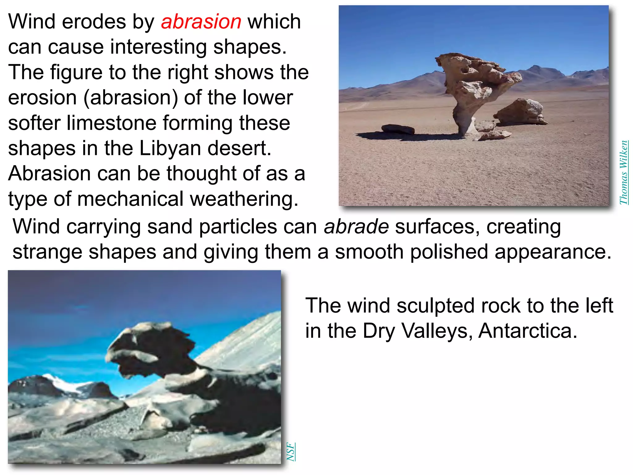
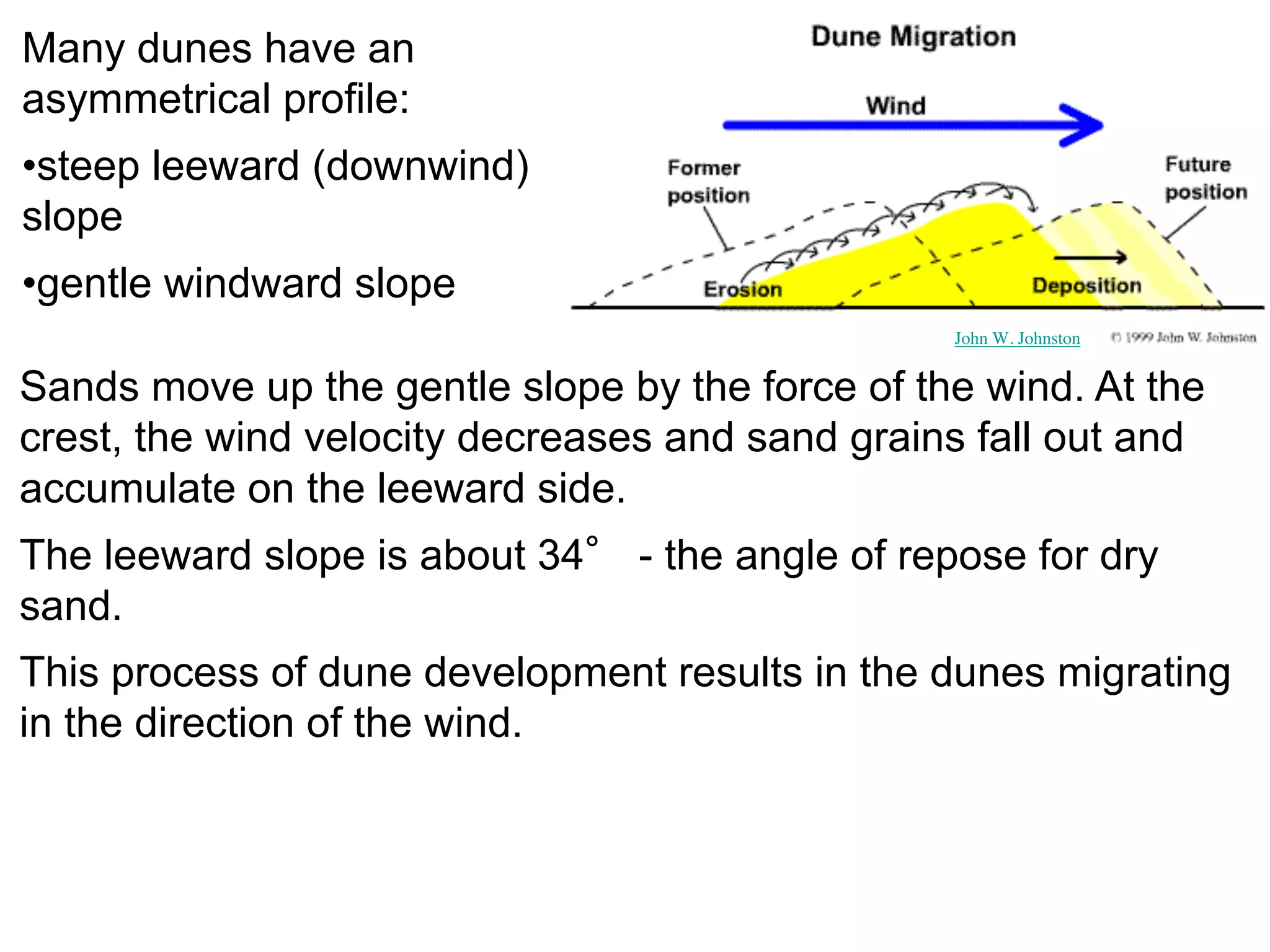
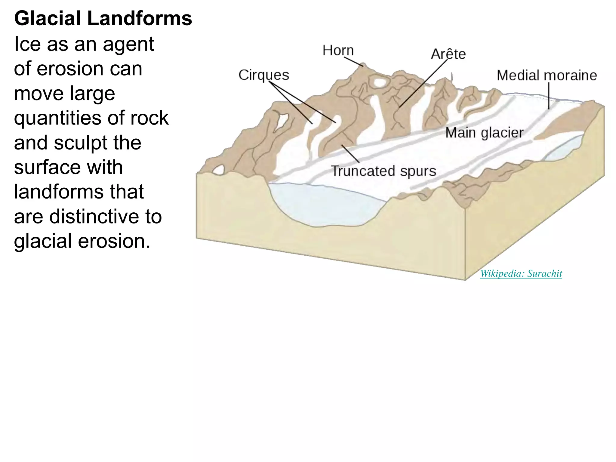
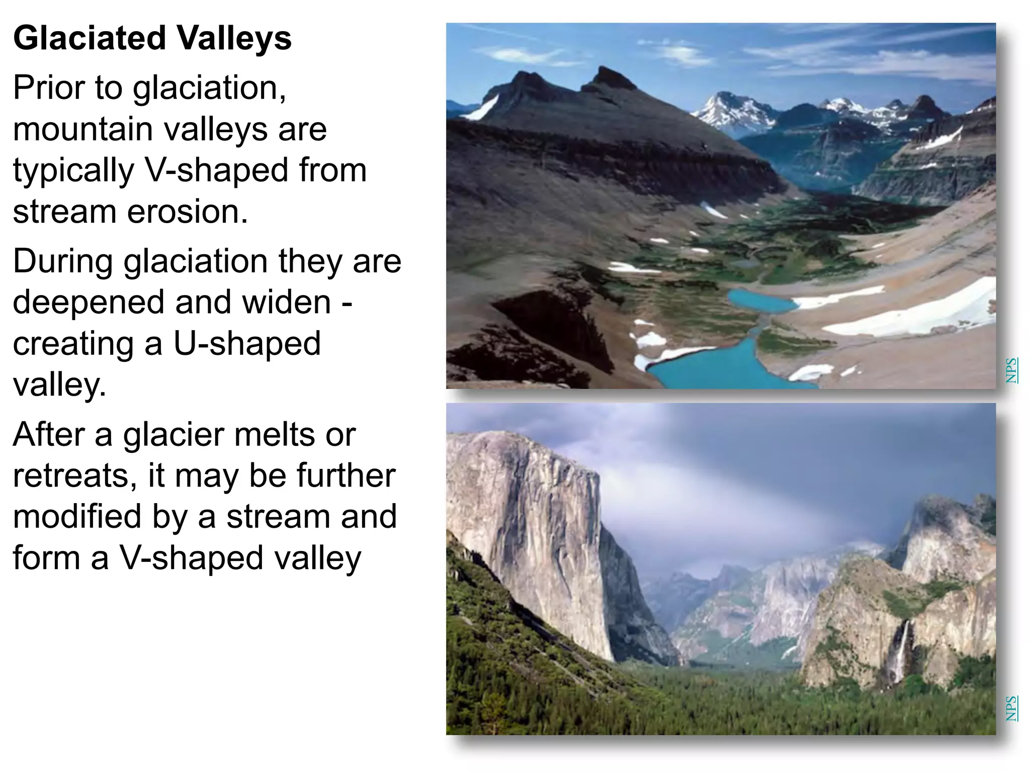
1
The Agents of Erosion
1. Erosion & Deposition
2. Water
3. Wind
4. Ice
California
Science Project
2
Erosion is the physical removal and
transport of material by mobile
agents such as water, wind or ice.
The three common agents of erosion
are:
• water
• wind
• Ice
These agents are mobile at the
Earth’s surface and are responsible
for the transport of sediment.
USGS
NWS
USGS
1. Erosion and Deposition
3
Erosion and mass wasting appear
to be similar processes but have
distinctly different causes.
The movement of sediment by
erosion requires mobile agents
such a water, wind and ice. That is,
the sediment is transported by the
movement of the agents.
USGS
Mass wasting (commonly referred to as
landslides) involves the transfer of rock
and soil downslope under the influence of
gravity. Gravity is the key factor in mass
wasting and the movement of material
does not require a mobile agent.
USGS
Weathering results in two types of products:
1. solid particles (sand grains, clay minerals, etc.)
2. dissolved constituents in water
These different types of sediment result in two fundamentally
different types of sedimentary rocks:
1. detrital (clastic) sedimentary rocks - formed from transported
solid particles (detritus or clasts).
2. chemical sedimentary rocks - formed by the precipitation of
dissolved substances by either inorganic or biologic processes
river rocks salt flat
Size Range (mm) Particle Name Sediment Name Rock Name
>256 Boulder
Gravel
Conglomerate
or Breccia
64 - 256 Cobble
4 - 64 Pebble
2 - 4 Granule
1/16 - 2 Sand Sand Sandstone
1/256 - 1/16 Silt
Mud
Shale or
Mudstone
<1/256 Clay
Particle Size Classification of Detrital Sedimentary Rocks
6
Erosion (transport of sediment) usually ends with the deposition
of sediments (and soil). Deposition occurs when the forces
responsible for erosion are no longer sufficient to transport the
sediment.
Wikimedia: Minkenorton
There are a
wide variety of
environments
on the Earth’s
surface where
the deposition
of sediments
occur as the
result of fluvial
(rivers), aeolian
(wind) and
glacial (ice)
erosion.
The particle shape may indicate
information about origin and
transport (rounded v. angular).
Sizes of particles can provide
useful information about the
environment of deposition:
• Gravels are found in high
energy environments such as
mountain streams and some
beaches.
• Sands are found in
intermediate energy
environments such as beaches
and river deposits.
• Clays are found in quiet
environments such as lakes and
the deep ocean.
2. Erosion by Water
Water is the most efficient and
effective agent for erosion.
Erosion by water commonly occurs in
two different geologic settings:
1. Coastlines – erosion that occurs
on coastlines is due to the action
of ocean currents, waves, and
tides.
2. Streams and Rivers – erosion
commonly occurs along the bank
of the stream. A stream is any size
channelized body of running
water (small creeks to giant
rivers).
USGS
Streams are able to transport sediment very long distances. There
are different types of material carried by a stream depending on
the size and chemical properties.
1) Dissolved load - transport of ions and chemicals in solution -
responsible for the saltiness of the sea.
2) Suspended Load - typically the largest load - clays, silt and fine
sand. This material settles out when the river slows (settling
velocity) usually in an ocean or lake.
3) Bed Load - the material that
is transported along the
river bed - rolling, sliding
and saltation - where the
particles bounce or skip
along the river bed.
10
The sediment found in a river bed is
evidence of the type of sediment that is
being transported.
The sediments found in a river bed are
indicative of the energy of the river.
The stream gradient is the grade or the
drop in elevation of a stream (as a
ratio) and is usually expressed as
feet/mile or m/km. The higher the
gradient, the greater the energy in the
stream.
Very high energy mountain streams can
transport large particles, boulders and
gravel whereas lower energy streams
can only transport more fine sediment
such as silt and clay.
Geographer Online
NPS
Streams will erode the surface by cutting
downward and tend to form V-shape
valleys. Rivers with steep gradients tend
to form steep walls. Rivers with shallower
gradients tend to form broader valleys.
When a stream has a very shallow
gradient (nearly flat), most of the
erosion is lateral (side to side) and
sediment is deposited forming flood
plains. The stream valley can be
very broad and gentle.
USGS
Streams form a wide
variety of landforms due to
erosion and the deposition
of sediments.
Alluvial fans and deltas are
landforms that result from
the deposition of
sediments. They are
similar structures, and differ
mainly by being deposited
either above or below
water. They are formed
from the deposition of the
sediment carried by the
river it flows into a canyon
or flatter plain (fan) or an
ocean or a lake (delta).
USGS
NOAA
13
Compared to running water and
glaciers, wind erosion is relatively
insignificant as an agent of erosion.
It is more effective in dry lands
compared to humid environments.
The photo to the right (NASA)
shows a small dust storm blowing
from Sudan onto the Red Sea.
In the 1930's, large dust storms
occurred in the midwest of the
U.S. - "Dust Bowl." This occurred
because of poor soil practices
(elimination of vegetation) and a
severe drought.
3. Erosion by Wind
NASA
NOAA
1. Wind's lower density
compared to water
makes it less capable of
picking up and depositing
coarse material
2. Wind is not confined to
channels - it can spread
over large areas.
The suspended load of
wind consists of silt and
clay particles - small and
platy grains may take
days to settle down.
The transport of sediment by wind differs from running water in
two important ways:
NASA satellite image of dust storm blowing
off the Sahara Desert across the
Mediterranean Sea toward Italy.
In arid regions, wind erodes the
surface through a process called
deflation. Deflation lowers the surface
by removing the finer grain material
(sand, silt, clay) and leaving the
coarser material.
Stephen
A.
Nelson
(Tulane)
Desert pavement develops as a result of deflation leaving the
surface covered with pebbles and cobbles. Other processes
may also lead to the development of desert pavement.
Mark
A.
Wilson
Wind erodes by abrasion which
can cause interesting shapes.
The figure to the right shows the
erosion (abrasion) of the lower
softer limestone forming these
shapes in the Libyan desert.
Abrasion can be thought of as a
type of mechanical weathering.
Wind carrying sand particles can abrade surfaces, creating
strange shapes and giving them a smooth polished appearance.
The wind sculpted rock to the left
in the Dry Valleys, Antarctica.
Thomas
Wilken
NSF
Sand Dunes
Wind commonly
deposits sand in
mounds or ridges
called dunes.
Dunes commonly form around
a clump of vegetation or a
rock - where the wind velocity
is decreased (wind shadow).
The wind drops its sediment
load making the obstacle even
larger - self-propagating
process.
NPS
Many dunes have an
asymmetrical profile:
•steep leeward (downwind)
slope
•gentle windward slope
Sands move up the gentle slope by the force of the wind. At the
crest, the wind velocity decreases and sand grains fall out and
accumulate on the leeward side.
The leeward slope is about 34° - the angle of repose for dry
sand.
This process of dune development results in the dunes migrating
in the direction of the wind.
John W. Johnston
As the sand is deposited on
the leeward side, the sand is
inclined in the direction that the
wind is blowing. These sloping
layers are called cross beds.
The photo depicts a
sandstone in Zion
National Park that
shows preserved
sand dunes. Note the
well-preserved cross
beds.
John W. Johnston
NPS
20
Glaciers cover nearly 10 % of the Earth (decreasing steadily), but
in the past, about 30% was covered.
They are responsible for the basic character of:
• European and Southern Alps (NZ).
• Cape Cod & Long Island.
• Yosemite Valley, Glacier National Park, Grand Tetons
• Hudson Bay, Great Lakes, Fiords of Norway & Alaska
4. Erosion by Ice
Frank Paul, University of Zurich NASA
50m
Brittle (fractures)
Ductile (flows)
Bedrock
A glacier is a thick ice mass that originates on land by the
accumulation, compaction and recrystallization of snow.
• Glaciers are capable of flow, and therefore move downhill
under the force of gravity.
• When ice accumulates to greater than 50 m thick, the ice
below 50m can flow. The ice above 50 m remains brittle,
below it is ductile.
Glacial Erosion
As sediment-laden ice moves over rocks, it abrades (polishes)
them and may leave grooves or glacial striations on the rock
surface.
Tom
Lowell
NSIDC
Glacial abrasion can be
thought of as a type of
mechanical weathering.
USGS
Glacial Landforms
Ice as an agent
of erosion can
move large
quantities of rock
and sculpt the
surface with
landforms that
are distinctive to
glacial erosion.
Wikipedia: Surachit
Glaciated Valleys
Prior to glaciation,
mountain valleys are
typically V-shaped from
stream erosion.
During glaciation they are
deepened and widen -
creating a U-shaped
valley.
After a glacier melts or
retreats, it may be further
modified by a stream and
form a V-shaped valley
NPS
NPS
25
Glacial Deposits
The general term for all types of glacial materials is glacial drift.
Drift can be broken into 2 groups:
1) Glacial Till - material that is deposited directly by a glacier and
is not sorted by size , and;
2) Stratified Drift or Outwash - deposited by meltwater from the
glacier and the sediment is sorted according to size.
Glacial drift is
deposited in a wide
variety of landforms
© Hans Hillewaert / CC-BY-SA-3.0
26
Moraines are a deposit of
sediment that forms from the
direct action of a glacier.
The figure on the right shows
the different types of
moraines that can be formed.
The image below shows
lateral moraines exposed
after the retreat of the glacier.
Wikipedia: Audriusa
BBC
USGS

Tekstong argumentatibo

  • 1.
    1 The Agents ofErosion 1. Erosion & Deposition 2. Water 3. Wind 4. Ice California Science Project
  • 2.
    2 Erosion is thephysical removal and transport of material by mobile agents such as water, wind or ice. The three common agents of erosion are: • water • wind • Ice These agents are mobile at the Earth’s surface and are responsible for the transport of sediment. USGS NWS USGS 1. Erosion and Deposition
  • 3.
    3 Erosion and masswasting appear to be similar processes but have distinctly different causes. The movement of sediment by erosion requires mobile agents such a water, wind and ice. That is, the sediment is transported by the movement of the agents. USGS Mass wasting (commonly referred to as landslides) involves the transfer of rock and soil downslope under the influence of gravity. Gravity is the key factor in mass wasting and the movement of material does not require a mobile agent. USGS
  • 4.
    Weathering results intwo types of products: 1. solid particles (sand grains, clay minerals, etc.) 2. dissolved constituents in water These different types of sediment result in two fundamentally different types of sedimentary rocks: 1. detrital (clastic) sedimentary rocks - formed from transported solid particles (detritus or clasts). 2. chemical sedimentary rocks - formed by the precipitation of dissolved substances by either inorganic or biologic processes river rocks salt flat
  • 5.
    Size Range (mm)Particle Name Sediment Name Rock Name >256 Boulder Gravel Conglomerate or Breccia 64 - 256 Cobble 4 - 64 Pebble 2 - 4 Granule 1/16 - 2 Sand Sand Sandstone 1/256 - 1/16 Silt Mud Shale or Mudstone <1/256 Clay Particle Size Classification of Detrital Sedimentary Rocks
  • 6.
    6 Erosion (transport ofsediment) usually ends with the deposition of sediments (and soil). Deposition occurs when the forces responsible for erosion are no longer sufficient to transport the sediment. Wikimedia: Minkenorton There are a wide variety of environments on the Earth’s surface where the deposition of sediments occur as the result of fluvial (rivers), aeolian (wind) and glacial (ice) erosion.
  • 7.
    The particle shapemay indicate information about origin and transport (rounded v. angular). Sizes of particles can provide useful information about the environment of deposition: • Gravels are found in high energy environments such as mountain streams and some beaches. • Sands are found in intermediate energy environments such as beaches and river deposits. • Clays are found in quiet environments such as lakes and the deep ocean.
  • 8.
    2. Erosion byWater Water is the most efficient and effective agent for erosion. Erosion by water commonly occurs in two different geologic settings: 1. Coastlines – erosion that occurs on coastlines is due to the action of ocean currents, waves, and tides. 2. Streams and Rivers – erosion commonly occurs along the bank of the stream. A stream is any size channelized body of running water (small creeks to giant rivers). USGS
  • 9.
    Streams are ableto transport sediment very long distances. There are different types of material carried by a stream depending on the size and chemical properties. 1) Dissolved load - transport of ions and chemicals in solution - responsible for the saltiness of the sea. 2) Suspended Load - typically the largest load - clays, silt and fine sand. This material settles out when the river slows (settling velocity) usually in an ocean or lake. 3) Bed Load - the material that is transported along the river bed - rolling, sliding and saltation - where the particles bounce or skip along the river bed.
  • 10.
    10 The sediment foundin a river bed is evidence of the type of sediment that is being transported. The sediments found in a river bed are indicative of the energy of the river. The stream gradient is the grade or the drop in elevation of a stream (as a ratio) and is usually expressed as feet/mile or m/km. The higher the gradient, the greater the energy in the stream. Very high energy mountain streams can transport large particles, boulders and gravel whereas lower energy streams can only transport more fine sediment such as silt and clay.
  • 11.
    Geographer Online NPS Streams willerode the surface by cutting downward and tend to form V-shape valleys. Rivers with steep gradients tend to form steep walls. Rivers with shallower gradients tend to form broader valleys. When a stream has a very shallow gradient (nearly flat), most of the erosion is lateral (side to side) and sediment is deposited forming flood plains. The stream valley can be very broad and gentle. USGS
  • 12.
    Streams form awide variety of landforms due to erosion and the deposition of sediments. Alluvial fans and deltas are landforms that result from the deposition of sediments. They are similar structures, and differ mainly by being deposited either above or below water. They are formed from the deposition of the sediment carried by the river it flows into a canyon or flatter plain (fan) or an ocean or a lake (delta). USGS NOAA
  • 13.
    13 Compared to runningwater and glaciers, wind erosion is relatively insignificant as an agent of erosion. It is more effective in dry lands compared to humid environments. The photo to the right (NASA) shows a small dust storm blowing from Sudan onto the Red Sea. In the 1930's, large dust storms occurred in the midwest of the U.S. - "Dust Bowl." This occurred because of poor soil practices (elimination of vegetation) and a severe drought. 3. Erosion by Wind NASA NOAA
  • 14.
    1. Wind's lowerdensity compared to water makes it less capable of picking up and depositing coarse material 2. Wind is not confined to channels - it can spread over large areas. The suspended load of wind consists of silt and clay particles - small and platy grains may take days to settle down. The transport of sediment by wind differs from running water in two important ways: NASA satellite image of dust storm blowing off the Sahara Desert across the Mediterranean Sea toward Italy.
  • 15.
    In arid regions,wind erodes the surface through a process called deflation. Deflation lowers the surface by removing the finer grain material (sand, silt, clay) and leaving the coarser material. Stephen A. Nelson (Tulane) Desert pavement develops as a result of deflation leaving the surface covered with pebbles and cobbles. Other processes may also lead to the development of desert pavement. Mark A. Wilson
  • 16.
    Wind erodes byabrasion which can cause interesting shapes. The figure to the right shows the erosion (abrasion) of the lower softer limestone forming these shapes in the Libyan desert. Abrasion can be thought of as a type of mechanical weathering. Wind carrying sand particles can abrade surfaces, creating strange shapes and giving them a smooth polished appearance. The wind sculpted rock to the left in the Dry Valleys, Antarctica. Thomas Wilken NSF
  • 17.
    Sand Dunes Wind commonly depositssand in mounds or ridges called dunes. Dunes commonly form around a clump of vegetation or a rock - where the wind velocity is decreased (wind shadow). The wind drops its sediment load making the obstacle even larger - self-propagating process. NPS
  • 18.
    Many dunes havean asymmetrical profile: •steep leeward (downwind) slope •gentle windward slope Sands move up the gentle slope by the force of the wind. At the crest, the wind velocity decreases and sand grains fall out and accumulate on the leeward side. The leeward slope is about 34° - the angle of repose for dry sand. This process of dune development results in the dunes migrating in the direction of the wind. John W. Johnston
  • 19.
    As the sandis deposited on the leeward side, the sand is inclined in the direction that the wind is blowing. These sloping layers are called cross beds. The photo depicts a sandstone in Zion National Park that shows preserved sand dunes. Note the well-preserved cross beds. John W. Johnston NPS
  • 20.
    20 Glaciers cover nearly10 % of the Earth (decreasing steadily), but in the past, about 30% was covered. They are responsible for the basic character of: • European and Southern Alps (NZ). • Cape Cod & Long Island. • Yosemite Valley, Glacier National Park, Grand Tetons • Hudson Bay, Great Lakes, Fiords of Norway & Alaska 4. Erosion by Ice Frank Paul, University of Zurich NASA
  • 21.
    50m Brittle (fractures) Ductile (flows) Bedrock Aglacier is a thick ice mass that originates on land by the accumulation, compaction and recrystallization of snow. • Glaciers are capable of flow, and therefore move downhill under the force of gravity. • When ice accumulates to greater than 50 m thick, the ice below 50m can flow. The ice above 50 m remains brittle, below it is ductile.
  • 22.
    Glacial Erosion As sediment-ladenice moves over rocks, it abrades (polishes) them and may leave grooves or glacial striations on the rock surface. Tom Lowell NSIDC Glacial abrasion can be thought of as a type of mechanical weathering. USGS
  • 23.
    Glacial Landforms Ice asan agent of erosion can move large quantities of rock and sculpt the surface with landforms that are distinctive to glacial erosion. Wikipedia: Surachit
  • 24.
    Glaciated Valleys Prior toglaciation, mountain valleys are typically V-shaped from stream erosion. During glaciation they are deepened and widen - creating a U-shaped valley. After a glacier melts or retreats, it may be further modified by a stream and form a V-shaped valley NPS NPS
  • 25.
    25 Glacial Deposits The generalterm for all types of glacial materials is glacial drift. Drift can be broken into 2 groups: 1) Glacial Till - material that is deposited directly by a glacier and is not sorted by size , and; 2) Stratified Drift or Outwash - deposited by meltwater from the glacier and the sediment is sorted according to size. Glacial drift is deposited in a wide variety of landforms © Hans Hillewaert / CC-BY-SA-3.0
  • 26.
    26 Moraines are adeposit of sediment that forms from the direct action of a glacier. The figure on the right shows the different types of moraines that can be formed. The image below shows lateral moraines exposed after the retreat of the glacier. Wikipedia: Audriusa BBC USGS