DISCOVERY OF AMERICA
•Download as DOC, PDF•
1 like•648 views

The document summarizes the interpretations of an archeologist regarding a petroglyph found in Sardinia containing three squares. It is argued that the petroglyph tells the story of discoveries of three continents - Australia, North America, and South America - by Egyptian pharaohs from the 3rd to 5th dynasties, between around 2750 BC to 2400 BC. Specific kings and sailing routes connecting Egypt to locations in the discovered lands are identified based on interpretations of the positioning and sizes of the squares relative to latitude lines and distances.

Recommended
More Related Content
What's hot
What's hot (20)
Similar to DISCOVERY OF AMERICA
Recently uploaded
Recently uploaded (20)
DISCOVERY OF AMERICA
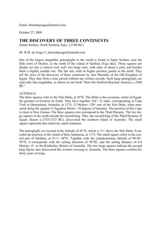
- 1. Email: drsrmdejonge@hotmail.com October 27, 2009 THE DISCOVERY OF THREE CONTINENTS (Santo Stefano, North Sardinia, Italy, c.2300 BC) Dr. R.M. de Jonge ©, drsrmdejonge@hotmail.com One of the largest megalithic petroglyphs in the world is found in Santo Stefano, near the little town of Oschiri, in the north of the island of Sardinia (Figs.1&2). Three squares are deeply cut into a vertical rock wall: two large ones, with sides of about a yard, and besides them a slightly smaller one. The last one, with its higher position, points to the north. They tell the story of the discovery of three continents by four Pharaohs of the Old Kingdom of Egypt. They date from a time period without any written records. Such large petroglyphs are typi-cally late-megalithic, as shown in our book “How the SunGod Reached America, c.2500 BC”. AUSTRALIA The three squares refer to the Nile Delta, at 30°N. The Delta is the economic center of Egypt, the greatest civilization on Earth. They have together 3x4= 12 sides, corresponding to Cape York in Queensland, Australia, at 12°S, 12 Moiras= 120° east of the Nile Delta, when mea- sured along the equator (1 Egyptian Moira= 10 degrees of latitude). The position of this Cape is close to New Guinea. The three squares also correspond to the Third Dynasty. The two lar- ge squares in the south encode the second king. Thus, the second king of the Third Dynasty of Egypt, Djoser (c.2753-2723 BC), discovered the southern island of Australia. The small square represents this relatively small continent. The petroglyphs are located at the latitude of 41°N, which is 11° above the Nile Delta. It en- codes the position of the island of Roti, Indonesia, at 11°S. The small square refers to the cen- tral part of Sardinia, at 41-1= 40°N. Together with the complementary latitude of 90-40= 50°N, it corresponds with the sailing direction of 50°SE, and the sailing distance of 0.4 Moiras= 4°, to the Kimberley District of Australia. The two large squares indicate the second king Djoser also discovered this western crossing to Australia. The three squares confirm his thirty years of reign.
- 2. Fig.1 Three large squares, deeply cut into a vertical rock wall, pointing to the north. They tell the story of the discovery of Australia, North America, and South America (from right to left), in the Third and Fourth Dynasties of Egypt. (c.2300 BC, Santo Stefano, Oschiri, at 41°N, North Sardinia, Photo: Anja Klein Wassink) AMERICA The monument is situated at 41°N. The two large squares refer to the southern part of Sardi- nia, at 41-2= 39°N. The Southern Aleutian Islands, near the Bering Sea, are located at the complementary latitude, at 90-39= 51°N. In antiquity the use of complementary latitudes was very common. These islands form the gate to America. The four sides of each square repre- sent the Fourth Dynasty. This important dynasty is indicated three times. The small square re- fers to the central part of Sardinia, at 41-1= 40°N, confirming this dynasty for the fourth time. Thus, America was discovered in the Fourth Dynasty. The complementary latitude line at 90-40= 50°N near the Aleutians encodes the fifth king. The fifth King Menkaure (Mycerinos, c.2580-2562 BC) of the Fourth Dynasty discovered the continents of North and South America. The two large squares represent these large conti- nents. On the return route, he also discovered the crossing of the Bering Strait, 4x4= 16° to the north, at 50+16= 66°N. The three squares provide the sailing direction of the Southern Crossing of the Atlantic Ocean, from the Cape Verde Islands, at 16°N, with the wind and the current, 30°SSW. The 50th latitude line, just mentioned, encodes the point of arrival, Cape São Roque (the Holy Rock), Brazil, at 5°S, but also the Fifth Dynasty. The two southern, large squares give the sai- ling distance, 2 Moiras= 20°, but also the second king. The second king of the Fifth Dynasty, Sahura (c.2510-2498 BC), discovered the Southern Crossing.
- 3. The two large squares represent the two islands of the West Azores, 2° south of the monu- ment, at 41-2= 39°N. They have 2x4= 8 sides, corresponding to Cape Race, Newfoundland, at 39+8= 47°N. The two large squares provide the (initial) sailing direction from Cape Race to the West Azores, 20°ESE, and the sailing distance, 2 Moiras= 20°, but also indicate the se- cond king. Sahura also discovered this important return route, with the wind and the current, to the Old World.- The two squares symbolize the discovery of these two Crossings by this second king. The 3x4= 12 sides of the squares confirm his twelve years of reign. The three squares correspond with the Northern Crossing of the Ocean, from the Shetland Is- lands, via the south point of Greenland, to Cape Chidley, Canada, all three situated at the complementary latitude of the Nile Delta, at 90-30= 60°N. One crossed from the Shetland Is- lands to the Faeroes, then to Iceland, then to Cape Holm, Greenland, and finally from West Greenland to Baffin Island. The four sides of each square represent these four sailing distan- ces, each of them about ½ Moira= 5°. The three squares represent the next, third king. The third, small square in the north confirms it. So, the third king of the Fifth Dynasty, Nefererkare (c.2498-2478 BC), discovered the Nor- thern Crossing.- The third, small square symbolizes the discovery of this third Crossing of the Ocean by the third king. The two large squares confirm his twenty years of reign. Bermuda The three squares symbolize the three island groups of the Azores, the East, Central, and West Azores, 3° to the south, at 41-3= 38°N. Together these consist of nine islands. They refer to the island of Bermuda, 9° south of the monument, at 41-9= 32°N (about 9° offshore), as well as the mentioned latitude line, 9° north of the squares, at 41+9= 50°N. So, the return route via Bermuda was discovered in the Fifth Dynasty, by the ninth and last king Unas (c.2403-2370 BC), to be precise. The three squares encode the long sailing distance from Bermuda to the Azores, with the wind and the current, 3 Moiras= 30°. They also indicate the islands of Madeira, 3° above the Nile Delta, at 33°N. These islands are important for the return route. Their latitude confirms the 33 years of reign of king Unas.- This whole story is affirmed in a dozen megalithic monuments in Europe. Bermuda is located 9+9= 18° below the 50th latitude line, at 50-18= 32°N. It confirms the eighteen years of reign of king Menkaure (Mycerinos), who discovered America.- The Nor- thern Crossing of the Atlantic, via the 60th latitude line through the south point of Greenland, was the last discovered sailing route to the new continent. Probably, it encodes the date of this petroglyph in the Sixth Dynasty (c.2370-2189 BC). * Previously, this article was published in “Ancient American”, Vol.12, No.76 (2007)
- 4. Fig.2 The rock with the three squares in the beautiful but dry landscape of Sardinia. On the foreground are other large petroglyphs. (View west, Santo Stefano, Oschiri, Sardinia, Photo: Anja Klein Wassink)