INDIAN ROCK HOUSE, ARKANSAS
•Download as DOC, PDF•
1 like•943 views

Email: drsrmdejonge@hotmail.com March 19, 2011 EGYPTIAN DISCOVERY OF AMERICA (c.2470 BC, Indian Rock House, Fairfield Bay, Arkansas) Dr. R.M. de Jonge ©, drsrmdejonge@hotmail.com

Recommended
More Related Content
What's hot
What's hot (20)
Similar to INDIAN ROCK HOUSE, ARKANSAS
Similar to INDIAN ROCK HOUSE, ARKANSAS (13)
More from INSTITUTE OF MEGALITHIC RESEARCH
More from INSTITUTE OF MEGALITHIC RESEARCH (7)
Recently uploaded
Recently uploaded (20)
INDIAN ROCK HOUSE, ARKANSAS
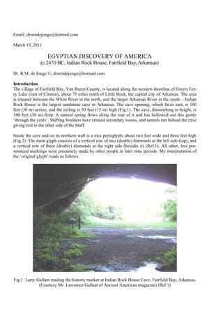
- 1. Email: drsrmdejonge@hotmail.com March 19, 2011 EGYPTIAN DISCOVERY OF AMERICA (c.2470 BC, Indian Rock House, Fairfield Bay, Arkansas) Dr. R.M. de Jonge ©, drsrmdejonge@hotmail.com Introduction The village of Fairfield Bay, Van Buren County, is located along the western shoreline of Greers Fer- ry Lake (east of Clinton), about 75 miles north of Little Rock, the capital city of Arkansas. The area is situated between the White River in the north, and the larger Arkansas River in the south. - Indian Rock House is the largest sandstone cave in Arkansas. The cave opening, which faces east, is 100 feet (30 m) across, and the ceiling is 50 feet (15 m) high (Fig.1). The cave, diminishing in height, is 100 feet (30 m) deep. A natural spring flows along the rear of it and has hollowed out this grotto ‘through the years’. Shifting boulders have created secondary rooms, and tunnels run behind the cave giving exit to the other side of the bluff. Inside the cave and on its northern wall is a nice petroglyph, about two feet wide and three feet high (Fig.2). The main glyph consists of a vertical row of two (double) diamonds at the left side (top), and a vertical row of three (double) diamonds at the right side (besides it) (Ref.1). All other, less pro- nounced markings were presumely made by other people in later time periods. My interpretation of the ‘original glyph’ reads as follows. Fig.1 Larry Gallant reading the historic marker at Indian Rock House Cave, Fairfield Bay, Arkansas. (Courtesy Mr. Lawrence Gallant of Ancient American magazine) (Ref.1)
- 2. Discovery of America The two (double) diamonds at the left side above, each having four sides, mean that the two conti- nents of North and South America were discovered in the Fourth Dynasty of Egypt. The discovery happened via the two sailing routes in the northwest (two diamonds at the left side above). The total number of 2+3= 5 diamonds in the glyph show this discovery was accomplished via the southern Aleutian islands, at about 50°N, by the 5th king Menkaure (Mycerinos, c.2580-2562 BC). The fifth (isolated) diamond at the right side above confirms the simultaneous discovery of the Bering Strait by this 5th king. (Refs.2-6) The three diamonds at the right side confirm he was an Egyptian king from the Nile Delta, at about 30°N. His eighteen years of reign confirm he discovered the back side of the planet Earth, ‘the Realm of the Dead’, at a distance of 18 Egyptian Moiras, or 180°, from the Old World, ‘the Land of the Living’. He also discovered the south point of the Gulf of Campeche, Mexico, or the Land of Punt, at 18°N. He was the founder of the ancient civilization in Central America. The two lower diamonds at the right side show the subsequent discovery of the two southern cros- sings of the Atlantic Ocean by the 2nd king Sahura (c.2510-2498 BC) of the Fifth Dynasty (the 2+3= 5 diamonds). He crossed, with the wind and the current, from Africa to South America, and he retur- ned, also with the wind and the current, from Newfoundland to the Azores. Both crossings each have a length of about 2 Egyptian Moiras, or 20°. The three diamonds at the right side have a total number of 3x4= 12 sides, confirming his 12 years of reign. The third diamond at the right side above shows the discovery of the third crossing of the Atlantic from the Shetland Islands via the South Cape of Greenland to Cape Chidley, Canada, by the 3rd king Nefererkare (c.2498-2478 BC), at the complementary latitude of the Nile Delta, at 90°-30°= 60°N. (In antiquity, the use of complementary latitudes was very common.) The five diamonds have a total number of 5x4= 20 sides, confirming his 20 years of reign. (Refs.7-12). Between both vertical rows are two additional diamonds (see the glyph, Fig.2). The upper diamond symbolizes the 4th king Shepsekare (c.2478-2471 BC) of the Fifth Dynasty, who was the next pharaoh, as well as his complementary latitude line at 90°-54°= 36°N. (His number was 54.) It is the latitude of the Strait of Gibraltar, the entry of the Mediterranean Sea, as well as Cape Hatteras, the east cape of the USA. People celebrated the circumnavigation of the planet Earth, having a circumference of 36 Egyp- tian Moiras, or 360°. The total number of 5+2= 7 diamonds confirm his 7 years of reign. The lower diamond represents the 5th king Neferefre (c.2471-2468 BC) of this Dynasty (the next pharaoh), as well as his complementary latitude line of 90°-55°= 35°N. (His number was 55.) It is the latitude of Indian Rock House Cave, Fairfield Bay, Arkansas, at 35°N, where the petroglyph was made. It dates the glyph within his three years of reign, from c.2471 to 2468 BC, as shown by the three diamonds at the right side.
- 3. Fig.2 The main glyph consists of a vertical row of two diamonds at the left side (top), and a vertical row of three diamonds at the right side. (c.2470 BC, Indian Rock House Cave, Fairfield Bay, Arkansas) (Courtesy Mr. Lawrence Gallant of Ancient American magazine) (Ref.1) Discussion One of the largest megalithic petroglyphs in the world is found in Santo Stefano, near the little town of Oschiri, in the north of the island of Sardinia, Italy (Ref.5). Three diamonds are deeply cut into a vertical rock wall: two large ones, with sides of about a yard, and besides them a slightly smaller one (Fig.3). They tell the story of the discovery of Australia, North America and South America in the Third and Fourth Dynasties of Egypt. The petroglyph dates from c.2300 BC. The famous Phaistos Disc of Crete, Greece, dates from the end of the New Palace Culture, c.1458 BC (Refs.13,14). It provides an accurate description of the discovery of America, as shown above. The Disc has the spherical shape of the planet Earth, and not only the front side, but also the back side is covered with beautiful symbols, which confirms this discovery. This back side contains 4 turns of a rare script, and the front side has 5 turns, and in total there are 45 different symbols, twice celebrating the 5th king Menkaure of the Fourth Dynasty, who discovered America. The Disc also gives an accu- rate description of the metal trade (copper, tin, silver and gold) across the Atlantic Ocean between 2500 and 1450 BC (Refs.15-18). - The next cultural time period of Mycenaean Greece (c.1450-1100 BC) as well as its capital city of Mycenae are called after the Egyptian king Menkaure (Mycerinos), who discovered America.
- 4. The people of the USA live around the 40th latitude line (Columbus, Ohio, at 40°N), because of the Egyptian discovery of the continent in the Fourth Dynasty. The northern border roughly coincides with the 50th latitude line, in honor of the 5th king Menkaure, who actually did it. This border also refers to the Fifth Dynasty, when the Atlantic Ocean was crossed. The height of the country equals 2 Egyptian Moiras, or 20°, in honor of the 2nd king Sahura, who discovered the two southern Cros- sings. The southern border roughly coincides with the 30th latitude line, in honor of the 3rd king Nefererkare. He discovered the third, Northern Crossing, at the complementary latitude of the Nile Delta, at 30°N. (Refs.19,20) The capital of Washington D.C. is founded at the latitude of Cahokia and the West Azores, at 39°N, which is in the middle of the Ocean, but also because of the discovery of America via the southern Aleutian islands, at the complementary latitude of 90-39= 51°N. The ‘Pentagon’, the headquarters of the Unites States Department of Defense, is the world’s largest office building. It was built to re- member the Fifth Dynasty, when Egyptian kings crossed the Atlantic Ocean. It was the first circum- navigation of the planet Earth, having a circumference of 40,000 km. This round number is in honor of the Fourth Dynasty, when America was discovered. Fig.3 Three large diamonds, deeply cut into a vertical rock wall, pointing to the north. They tell the story of the discovery of Australia, North America, and South America (from right to left), in the Third and Fourth Dynasties of Egypt. (c.2300 BC, Santo Stefano, Oschiri, North Sardinia, Photo: Anja Klein Wassink) (Ref.5) References 1. Gallant, L.C., personal communication via MES, Website: www.midwesternepigraphic.org 2. De Jonge, R.M., and Wakefield, J.S., How the Sungod Reached America, c.2500 BC, A Guide to Megalithic Sites, MCS Inc., 2002 (ISBN 0-917054-19-9). Available: MCS Inc., Box 3392, Kirkland, Wa 98083, also on CD. Website: www.howthesungod.com
- 5. 3. Wakefield, J.S., and De Jonge, R.M., Rocks & Rows, Sailing Routes across the Atlantic and the Copper Trade, MCS Inc, 2010 (ISBN 0-917054-20-2). Available: MCS Inc, Box 3392, Kirkland, Wa USA 98033. Website: www.rocksandrows.com 4. De Jonge, R.M., and Wakefield, J.S., “The Discovery of the Atlantic Islands”, Ancient American, Vol.13, No.81, pgs.18-25 (2008). 5. De Jonge, R.M., “The Discovery of Three Continents (Santo Stefano, North Sardinia, Italy, c.2300 BC)”, Ancient American, Vol.12, No.76, pgs.28-29 (2007), Ref.6. 6. De Jonge, R.M., Website: www.slideshare.net/rmdejonge 7. De Jonge, R.M., “Houghton’s Petroglyph (Copper Country, Michigan, 2500-1200 BC)”, Ref.6 , to be published. 8. De Jonge, R.M., “The Mystic Symbol, mark of the Michigan Mound Builders”, Ref.6, to be pu- blished. 9. De Jonge, R.M., “Great Serpent Mound (c.2300 BC, Adams County, Ohio)”, Ref.6, to be publish- ed. 10. De Jonge, R.M., “Discovery of America and the Flood, (c.2300 BC, Ita Letra, Villarrica, Para- guay)”, Ref.6, to be published. 11. De Jonge, R.M., “The Battersea Shield (River Thames, London, c.190 BC)”, Ref.6, to be publish- ed. 12. De Jonge, R.M., “A Sword for America (Kirkburn, East Yorkshire, England, c.250 BC)”, Ref.6, to be published. 13. De Jonge, R.M., The Phaistos Disc Decoded, New Testimony of a Lost Civilization, Midwestern Epigraphic Journal, Vol.20, 111-115 (2006), and Vol.21, 74-80 (2007), to be published. 14. De Jonge, R.M., “Minoan Pendant (Cleveland, Ohio, c.1690 BC)”, Ref.6, to be published. 15. Rydholm, C.F., Michigan Copper, The Untold Story, Winter Cabin Books, Marquette, 2006 (ISBN 0-9744679-2-8). 16. De Jonge, R.M., “Copper Trade with the Old World (Poverty Point, NE Louisiana)”, Ref.6, to be published. 17. Gallant, L.C., “The Copper Plates from Peters Creek”, Ancient American, Vol.14, No.88, pgs.12-16 (2010). 18. De Jonge, R.M., “Peters Creek Mound, (c.715 BC, Clairton, Pennsylvania)”, Ref.6, to be publish- ed. 19. De Jonge, R.M., “The Myths of Monks Mound (Cahokia, Illinois, 650-1400 AD)”, Ref.6, to be published. 20. De Jonge, R.M., “Cahokia, Capital of Ancient America”, Ref.6, to be published.