COPPER SPEAR TIP, MN
•Download as DOC, PDF•
1 like•900 views

The copper spear tip found in Crow Wing County, Minnesota dates back to around 1500 BC. The artifact provides evidence that ancient Egyptians discovered America during the Old Kingdom and established colonies. It references historical events like the Biblical flood that occurred in the 6th dynasty, killing over 2 million people. The spear tip's design encodes information about early trans-Atlantic voyages between Egypt, North America, South America, and locations like the Azores islands. It appears to celebrate the large-scale copper trade between North America and the Old World during the reign of Queen Hatshepsut in the 18th dynasty of Egypt.

Recommended
More Related Content
What's hot
What's hot (20)
Similar to COPPER SPEAR TIP, MN
Similar to COPPER SPEAR TIP, MN (16)
Recently uploaded
Recently uploaded (20)
COPPER SPEAR TIP, MN
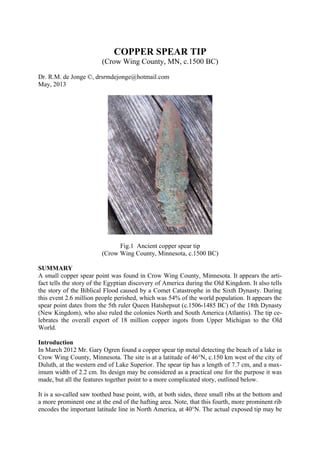
- 1. COPPER SPEAR TIP (Crow Wing County, MN, c.1500 BC) Dr. R.M. de Jonge ©, drsrmdejonge@hotmail.com May, 2013 Fig.1 Ancient copper spear tip (Crow Wing County, Minnesota, c.1500 BC) SUMMARY A small copper spear point was found in Crow Wing County, Minnesota. It appears the arti- fact tells the story of the Egyptian discovery of America during the Old Kingdom. It also tells the story of the Biblical Flood caused by a Comet Catastrophe in the Sixth Dynasty. During this event 2.6 million people perished, which was 54% of the world population. It appears the spear point dates from the 5th ruler Queen Hatshepsut (c.1506-1485 BC) of the 18th Dynasty (New Kingdom), who also ruled the colonies North and South America (Atlantis). The tip ce- lebrates the overall export of 18 million copper ingots from Upper Michigan to the Old World. Introduction In March 2012 Mr. Gary Ogren found a copper spear tip metal detecting the beach of a lake in Crow Wing County, Minnesota. The site is at a latitude of 46°N, c.150 km west of the city of Duluth, at the western end of Lake Superior. The spear tip has a length of 7.7 cm, and a max- imum width of 2.2 cm. Its design may be considered as a practical one for the purpose it was made, but all the features together point to a more complicated story, outlined below. It is a so-called saw toothed base point, with, at both sides, three small ribs at the bottom and a more prominent one at the end of the hafting area. Note, that this fourth, more prominent rib encodes the important latitude line in North America, at 40°N. The actual exposed tip may be
- 2. considered as the 5th part sticking out of the wooden pole, encoding the latitude line at 50°N. Note, that the spear tip was found at 46°N, which is in between these main latitude lines. - In Europe latitudes were already known c.4800 BC, as shown in the monument of Barnénez, Brittany, France. (Refs.1,2) Discovery of America Both the 4th rib and the 40th latitude line encode the Fourth Dynasty when America was dis- covered. The 5th part sticking out and the 50th latitude line encode the fifth King Menkaure (Mycerinos, c.2580-2562 BC), who accomplished this discovery via the southern Aleutian is- lands, at the south side of the Bering Sea, at c.50°N. The complementary latitude line at 90-50= 40°N confirms the discovery of America in the Fourth Dynasty. In antiquity the use of complementary latitudes was very common. - The complementary latitude line at 90-40= 50°N confirms the 5th king Menkaure who discovered America via the southern Aleutian islands, at c.50°N. The length of the 40th latitude line from coast to coast across North America equals 50°, confirming it. The holy Arctic Circle, at 67°N, is the northernmost line the Sun still shines at midwinter day (Sun religion). The spear tip shows king Menkaure also discovered the crossing of the Bering Strait, 1° below it, at 67-1= 66°N. So, he returned via the Upper North, 66-50= 16° above the southern Aleutian islands. (Refs.3-6) Atlantic Crossings The Southern Crossing of the Atlantic starts at the Cape Verde Islands, off shore West Africa, at 16°N (see above). Both the Nile Delta and the Mississippi Delta are located at 30°N, enco- ding its sailing direction, with the wind and the current, 30° SSW. The three small ribs at the bottom of the point confirm it. The 5th part sticking out and the 50th latitude line encode the point of arrival, Cape São Rock (the Holy Rock), Brazil, at 5°S. It shows the Southern Crossing was discovered in the Fifth Dynasty. The two prominent ribs at the end of the hafting area encode the length of the Cros- sing, 2 Egyptian Moiras, or 20°. It also shows the 2nd king Sahure (c.2510-2498 BC) of this dynasty discovered the Southern Crossing. The spear tip shows king Sahure returned from Cape Race, Newfoundland, 1° above the fin- ding spot in Crow Wing County, MN, at 46+1= 47°N. The initial sailing direction of 20° ESE across 2 Moiras, or 20°, to the two islands of the West Azores illustrates this Return Route, with the wind and the current, was discovered by the 2nd king Sahure, as well. - So, this 2nd king discovered the two southern crossings of the Ocean. (Refs.7-11) The two prominent ribs at the end of the hafting area and the exposed tip sticking out encode together the 3rd king Neferirkare (c.2498-2478 BC), who discovered the Northern Crossing of the Ocean from the Shetland Islands via the south cape of Greenland to Cape Chidley, Cana- da, at the complementary latitude of the Nile Delta, at 90-30= 60°N. As mentioned before: in antiquity the use of complementary latitudes was very common. The three small ribs at both sides confirm this latitude, at 90-30= 60°N. The three small ribs at each side encode Abaco Island, northern Bahama’s, 3° below the Mississippi Delta, at 30-3= 27°N. King Sahure of the Fifth Dynasty ruled for 12 years. So, the
- 3. sailing distance from Abaco Island to Bermuda, at 27+5= 32°N, equals 12 moiras, or 12°. He was the 2nd king, confirming Bermuda, 2° above the Delta, at 30+2= 32°N. Including the exposed tip the metal point has a total of 8+1= 9 protruding parts, confirming the latitude of Bermuda, 9° above the holy Tropic of Cancer, at 23+9= 32°N. The three small ribs at the bottom encode the three island groups of the Azores (the East, Central and West A- zores), together consisting of nine islands. The two prominent ribs at the end of the hafting area and the exposed tip sticking out confirm the three island groups of the Azores. So, the 9 protruding parts of the spear tip encode the 9th and last king Unas (c.2403-2370 BC), who discovered the long sailing route, with the wind and the current, from Bermuda to the nine islands of the Azores. The two prominent ribs and the long tip illustrate this long sailing distance of 3 Moiras, or 30°. (Refs.12-17) Sun religion The long spear tip has a top angle of 23° above the hafting area (Fig.1). Together with the prominent rib and the three small ribs below these the angle of 10+10+3= 23° may be confir- med. It encodes the holy Tropic of Cancer, at 23°N (as well as the holy Arctic Circle, at 90- 23= 67°N, mentioned earlier). At midsummer day the Sun is there at right angles above. The slow northerly movement of the Sun turns into a southerly movement. So, people believe in the Egyptian SunGod Ra. Far in the east the Tropic of Cancer crosses the River Nile. It is the center of the Southern Egyp- tian Empire, but also the center of the Sun religion. (Refs.3,4) Biblical Flood Then, suddenly, a huge Comet appeared in the sky. The Head of the Comet resembled Green- land, consisting of ice and stones. The Tail of the Comet resembled the North Atlantic Ocean, containing a huge amount of water. Note, the spear tip resembles a Comet. The three small ribs at both sides encode Cape Farvel, the south cape of Greenland, at the complementary latitude of the Nile Delta, at 90-30= 60°N. It shows it happened in the Sixth Dynasty. The SW Cape of Greenland is located at 60+1= 61°N. So, it happened during the reign of the 1st king Teti (c.2370-2338 BC). - This is correct, because it occurred c.2344 BC (tree-ring dating). The two prominent ribs at the end of the hafting area show it was a two-stage-event. The width of the spear equals 0.2 micromoiras, or 2.2 cm, confirming it (1 moira= 1°= 111 km). The three small ribs at both sides show the first time period lasted 30+30= 60 days. The planet Earth entered the Tail of the Comet. The falling stones were causing horrible forest-fires, and the melting ice resulted in torrential rains and worldwide floodings. It was completely dark on Earth. The three small ribs at both sides show the second time period also lasted 30+30= 60 days. The Earth left the Tail of the Comet, but the climate was completely disrupted. The terrible rains continued, but it also became very cold. So, the rains changed into ferrocious snow and hail storms.
- 4. The four ribs at each side of the hafting area illustrate the Comet Catastrophe lasted for a total of four months, or 4x30= 120 days. On the Northern Hemisphere the “complementary latitude” of Cape Farvel, Greenland, equals 180-60= 120°N, confirming it. (Refs.18-25) Casualties The four ribs at each side of the hafting area encode together the East Cape of Newfoundland, and North America, 4+4= 8° above the 40th latitude line, at 40+8= 48°N. The two prominent ribs confirm it, 2° above the finding spot of the spear, at 46+2= 48°N. It encodes the total world population before the Disaster: 4.8 million men. The relative latitude of the site encodes the number of casualties: (48/90)x48= 2.6 million men (54%). The length of the tip equals 0.7 micromoiras, or 7.7 cm, corresponding with the 7 figures of this number. The two prominent ribs and the six small ribs below them confirm it: 20+6= 26 million men. - So, there were 4.8-2.6= 2.2 million survivors. Most of them were seriously injured. The 5th part sticking out and the 4th prominent rib confirm the percentage of casualties: 54%. The latitude of Groswater Bay, Labrador, at 54°N, confirms it. Cape Hatteras and the Strait of Gibraltar, the exit of the Med, are located at the complementary latitude of 90-54= 36°N. It corresponds to the circumference of the Earth, 36 Moiras, or 360°. It confirms it was a wordwide Catastrophe. The four ribs at each side of the hafting area encode together the total precipitation during the Flood, 40+40= 80 micromoiras= 80x0.11= 9 meters of water. It corresponds with the volume of an ice-ball with a diameter of 200 km. The Disaster ended all ancient civilizations on Earth, including the Old Kingdom of Egypt. (Refs.26-29) Copper Trade Including the exposed tip the spear point has a total of 8+1= 9 protruding parts, referring to the nine islands of the Azores in the middle of the Ocean. It also refers to Isle Royale, Lake Superior, 9° above the westernmost islands, at 39+9= 48°N. It may be considered as the cen- ter of copper mining in North America. The spear point was made from this copper. It also refers to the density of copper, nine times heavier than water. (Refs.30-33) Isle Royale is located 48-30= 18° above the Mississippi Delta, referring to the civilization around the south point of the Gulf of Campeche, Mexico, at 18°N. It was considered as “the center of the Realm of the Dead, at the other side of the Waters (the Ocean), in the Land where the Sun sets (America)” (Sun religion). It was the Land of Punt, the holiest place of the America’s, at a symbolic distance of 18 Moiras, or 180° from the Land of the Living (Egypt). It corresponds with half the circumference of the planet Earth. – It confirms the 18 years of reign of king Menkaure (Mycerinos, c.2580-2562 BC), who discovered America. Dating The copper spear point dates from the time of the copper trade during the Empire of Atlantis (c.2500-1200 BC), which consisted of Egypt with its colonies North and South America. However, the artifact has two prominent ribs and the long, exposed tip, apparently referring to the third time period of good government, which was the New Kingdom (c.1580-1070 BC). It has a total of 8+1= 9 protruding parts, probably referring to the 2x9= 8+10= 18th Dynasty (c.1580-1314 BC). The exposed tip is the 5th and most important part, probably referring to the 5th ruler of this dynasty, which was Queen Hatshepsut (c.1506-1485 BC).
- 5. According to the Phaistos Disc of Crete (c.1458 BC) the overall copper export from Upper Michigan was 18 million copper ingots, as confirmed by the 2x9= 18 protruding parts of the spear tip (see above). The 8 ribs of the hafting area and the exposed tip, which is the 5th and most important part, show the standard ingot weighed 80 thousand carats (a number of five fi- gures), or 80x0.2= 16 kg. - So, it appears the spear tip celebrates the export of 18x16= c.288 thousand tons of copper to the Old World. Bronze was made by alloying the copper with 10% tin. (The words “tin” and “ten” are even related.) Although generally unknown, a lot of it was exported from South America. The spear tip also refers to the tin mines near the present town of Oruro, Bolivia, at 18°S. It cele- brates the overall export of tin was 10% of the copper, or 1.8 million tin ingots. The length of the tip equals 0.7 micromoiras, or 7.7 cm, corresponding with the 7 figures of this number. It also corresponds with the density of tin, seven times heavier than water. The quantity corres- ponds with c.28,8 thousand tons of tin. (Refs.11,34-45) References 1. Robin Mueller, FB Group: “Old Copper Complex and Ancient Waterways America”. (Larry Furo) 2. Susan English, Yahoo Group of the Ancient Waterways Society. 3. De Jonge, R.M., and Wakefield, J.S., How the SunGod Reached America c.2500 BC, A Guide to Megalithic Sites, 2002 (ISBN 0-917054-19-9). Available: MCS Inc., Box 3392, Kirkland, Wa 98083, also on CD. Website: www.howthesungod.com 4. Wakefield, J.S., and De Jonge, R.M., Rocks & Rows, Sailing Routes across the Atlantic and the Copper Trade, MCS Inc, 2010 (ISBN 0-917054-20-2). Available: MCS Inc, Box 3392, Kirkland, Wa USA 98083. Website: www.rocksandrows.com 5. De Jonge, R.M., Website: www.slideshare.net/rmdejonge 6. Pellech, Chr., Website: www.migration-diffusion.info 7. De Jonge, R.M., “The Discovery of Three Continents (Santo Stefano, North Sardinia, Italy, c.2300 BC)”, An- cient American, Vol.12, No.76, pgs.28-29 (2007), Ref.5. 8. De Jonge, R.M., “Houghton’s Petroglyph (Copper Country, Michigan, 2500-1200 BC)” (2009), Ref.5, to be published. 9. De Jonge, R.M., “The Mystic Symbol, mark of the Michigan Mound Builders” (2009), Ref.5, to be publish- ed. 10. De Jonge, R.M., “A Sword for America (Kirkburn, East Yorkshire, England, c.250 BC)” (2009), Ref.5, to be published. 11. De Jonge, R.M., “The Battersea Shield (River Thames, London, c.190 BC)” (2009), Ref.5, to be published. 12. De Jonge, R.M., and Wakefield, J.S., “Discovery of the Islands in the Ocean (Cairn T, Loughcrew, Co. Meath, Ireland, c.3200 BC)” (2011), Ref.5, to be published. 13. De Jonge, R.M., and Wakefield, J.S., "The Passage Grave of Karleby, Encoding the Islands Discovered in the Ocean, c.2950 BC", Migration & Diffusion, Vol.5, No.18, pgs.64-74 (2004), Ref.6. 14. De Jonge, R.M., and Wakefield, J.S., "The Three Rivers Petroglyph, A Guide-post for River Travel in Ame- rica", Migration & Diffusion, Vol.3, No.12, pgs.74-100 (2002), Ref.6. 15. De Jonge, R.M., and Wakefield, J.S., “A Nautical Center for Crossing the Ocean, America’s Stonehenge, New Hampshire, c.2200 BC”, Migration & Diffusion, Vol.4, No.15, pgs.60-100 (2003), Ref.6. 16. De Jonge, R.M., “Stonehenge, Monument for the Discovery of America (Salisbury Plain, South England, c.2000 BC)” (2011), Refs.5,6, to be published. 17. De Jonge, R.M., “Tripod Rock, Pyramid Mountain (Morris County, New Jersey, c.1900 BC)” (2011), Refs.- 5,6, to be published. 18. Peiser, B.J., Palmer, T., Bailey, M.E., Natural Catastrophes during Bronze Age Civilizations, BAR Interna- tional Series 728, Oxford, 1998 (ISBN 0-86054-916-X). 19. Baillie, M.G.L., “Hints that Cometary Debris played some Role in several Tree-Ring Dated Environmental Downturns in the Bronze Age”, Ref.18, pgs.109-117. 20. Peiser, B.J., “Evidence for a Global Disaster in the Late 3rd Millennium BC”, Ref.18, pgs.117-140. 21. Courty, M.-A., “The Soil Record of an Exceptional Event at 4000 BP in the Middle East”, Ref.18, pgs.93- 109. 22. Clube, S.V.M., and Napier, W.M., The Cosmic Serpent, Faber and Faber, London, 1982. 23. Clube, S.V.M., and Napier, W.M., The Cosmic Winter, Blackwell, Oxford, 1990.
- 6. 24. Joseph, F., Survivors of Atlantis, Their Impact on World Culture, Bear & Co., Vermont, 2004 (ISBN 1- 59143-0-040-2). 25. Baillie, M., Exodus to Arthur, Catastrophic Encounters with Comets, BT Batsford Ltd., London, 1999 (ISBN 0-7134-8681-3). 26. De Jonge, R.M., “The Comet Catastrophe of c.2345 BC”, (sixteen articles), Webpage: http://www.barry.warmkessel.com/dejonge.html 27. De Jonge, R.M., “Gold Ring (Grand Canyon, Arizona, c.1450 BC)” (2010), Ref.5, to be published. 28. De Jonge, R.M., “Sentinel Rock, Vermont (Discovery of America and Biblical Flood, c.1900 BC)” (2011), Refs.5,6, to be published. 29. De Jonge, R.M., “Oil City Glyphs (Pennsylvania, c. 2000 BC)” (2012), Ref.5, to be published. 30. Rydholm, C.F., Michigan Copper, The Untold Story, Winter Cabin Books, Marquette, 2006 (ISBN 0- 9744679-2-8). 31. De Jonge, R.M., “Copper Trade with the Old World (Poverty Point, NE Louisiana)” (2009), Ref. 5, to be pu- blished. 32. De Jonge, R.M., “Petroglyph of a Sailing Boat (Copper Harbor, Upper Michigan, c.1640 BC)” (2009), Ref.5, to be published. 33. De Jonge, R.M., “Minoan Pendant (Cleveland, Ohio, c.1690 BC)” (2010), Ref.5, to be published. 34. De Jonge, R.M., The Phaistos Disc Decoded, New Testimony of a Lost Civilization, 300 pgs., Netherlands (2008). Website: www.slideshare.net/drsrmdejonge 35. De Jonge, R.M., “The Bronze Doors of Rekhmire (Thebes, Upper Egypt, Eighteenth Dynasty, c.1460 BC)” (2011), Ref.5, to be published. 36. De Jonge, R.M., “The Myths of Monks Mound (Cahokia, Illinois, 650-1400 AD)” (2010), Ref.5, to be published. 37. De Jonge, R.M., “Cahokia, Capital of Ancient America” (2010), Ref.5, to be published. 38. De Jonge, R.M., “Peters Creek Mound (c.715 BC, Clairton, Pennsylvania)” (2010), Ref.5, to be published. 39. De Jonge, R.M., “Megaliths of Arrowhead Region I (Minnesota, c.1900 BC)” (2012), Ref.5, to be published. 40. De Jonge, R.M., “Megaliths of Arrowhead Region II (Minnesota, c.1900 and c.770 BC BC)” (2012), Ref.5, to be published. 41. De Jonge, R.M., “Great Serpent Mound (c.2300 BC, Adams County, Ohio)” (2010), Ref.5, to be published. 42. De Jonge, R.M., “Grave Creek Mound (I) (Moundville, Marshall County, WV)” (2012), Ref.5, to be pu- blished. 43. De Jonge, R.M., “Grave Creek Mound (II) (c.720 BC, Moundville, Marshall County, WV)” (2012), Ref.5, to be published. 44. Fell, B., America BC, Pocket Books, Simon & Schuster, 1994 (ISBN 0-671-67974-0). 45. Bailey, J., Sailing to Paradise, Simon & Schuster, 1994 (ISBN 0-684-81297-5).
- 7. 24. Joseph, F., Survivors of Atlantis, Their Impact on World Culture, Bear & Co., Vermont, 2004 (ISBN 1- 59143-0-040-2). 25. Baillie, M., Exodus to Arthur, Catastrophic Encounters with Comets, BT Batsford Ltd., London, 1999 (ISBN 0-7134-8681-3). 26. De Jonge, R.M., “The Comet Catastrophe of c.2345 BC”, (sixteen articles), Webpage: http://www.barry.warmkessel.com/dejonge.html 27. De Jonge, R.M., “Gold Ring (Grand Canyon, Arizona, c.1450 BC)” (2010), Ref.5, to be published. 28. De Jonge, R.M., “Sentinel Rock, Vermont (Discovery of America and Biblical Flood, c.1900 BC)” (2011), Refs.5,6, to be published. 29. De Jonge, R.M., “Oil City Glyphs (Pennsylvania, c. 2000 BC)” (2012), Ref.5, to be published. 30. Rydholm, C.F., Michigan Copper, The Untold Story, Winter Cabin Books, Marquette, 2006 (ISBN 0- 9744679-2-8). 31. De Jonge, R.M., “Copper Trade with the Old World (Poverty Point, NE Louisiana)” (2009), Ref. 5, to be pu- blished. 32. De Jonge, R.M., “Petroglyph of a Sailing Boat (Copper Harbor, Upper Michigan, c.1640 BC)” (2009), Ref.5, to be published. 33. De Jonge, R.M., “Minoan Pendant (Cleveland, Ohio, c.1690 BC)” (2010), Ref.5, to be published. 34. De Jonge, R.M., The Phaistos Disc Decoded, New Testimony of a Lost Civilization, 300 pgs., Netherlands (2008). Website: www.slideshare.net/drsrmdejonge 35. De Jonge, R.M., “The Bronze Doors of Rekhmire (Thebes, Upper Egypt, Eighteenth Dynasty, c.1460 BC)” (2011), Ref.5, to be published. 36. De Jonge, R.M., “The Myths of Monks Mound (Cahokia, Illinois, 650-1400 AD)” (2010), Ref.5, to be published. 37. De Jonge, R.M., “Cahokia, Capital of Ancient America” (2010), Ref.5, to be published. 38. De Jonge, R.M., “Peters Creek Mound (c.715 BC, Clairton, Pennsylvania)” (2010), Ref.5, to be published. 39. De Jonge, R.M., “Megaliths of Arrowhead Region I (Minnesota, c.1900 BC)” (2012), Ref.5, to be published. 40. De Jonge, R.M., “Megaliths of Arrowhead Region II (Minnesota, c.1900 and c.770 BC BC)” (2012), Ref.5, to be published. 41. De Jonge, R.M., “Great Serpent Mound (c.2300 BC, Adams County, Ohio)” (2010), Ref.5, to be published. 42. De Jonge, R.M., “Grave Creek Mound (I) (Moundville, Marshall County, WV)” (2012), Ref.5, to be pu- blished. 43. De Jonge, R.M., “Grave Creek Mound (II) (c.720 BC, Moundville, Marshall County, WV)” (2012), Ref.5, to be published. 44. Fell, B., America BC, Pocket Books, Simon & Schuster, 1994 (ISBN 0-671-67974-0). 45. Bailey, J., Sailing to Paradise, Simon & Schuster, 1994 (ISBN 0-684-81297-5).