CIRCLE CROSS CARVING, MI
•Download as DOC, PDF•
1 like•1,231 views

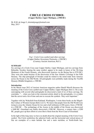
CIRCLE CROSS SYMBOL (Copper Harbor, Upper Michigan, c.1900 BC) Dr. R.M. de Jonge ©, drsrmdejonge@hotmail.com May, 2013 SUMMARY Six carvings of a Circle Cross near Copper Harbor, Upper Michigan, and two carvings from Bohuslän, Sweden, bearing the same symbol, appear to be made in honor of the 5th king Menkaure of the Fourth Dynasty, who discovered America via the Bering Sea (c.2570 BC). They were also made because of the discoveries of the four Atlantic Crossings in the Fifth Dynasty. The ship petroglyph of Sweden could be related to the metal trade from America across the Ocean to the Old World. All petroglyphs were probably made during the Twelfth Dynasty (Middle Kingdom), c.1900 BC.

Recommended
More Related Content
What's hot
What's hot (20)
Similar to CIRCLE CROSS CARVING, MI
Similar to CIRCLE CROSS CARVING, MI (15)
More from INSTITUTE OF MEGALITHIC RESEARCH
More from INSTITUTE OF MEGALITHIC RESEARCH (6)
Recently uploaded
Recently uploaded (20)
CIRCLE CROSS CARVING, MI
- 1. CIRCLE CROSS SYMBOL (Copper Harbor, Upper Michigan, c.1900 BC) Dr. R.M. de Jonge ©, drsrmdejonge@hotmail.com May, 2013 Fig.1 Circle Cross symbol (and other carving) (Copper Harbor, Keweenaw Peninsula, c.1900 BC) (Courtesy Ancient American, Ref.1) SUMMARY Six carvings of a Circle Cross near Copper Harbor, Upper Michigan, and two carvings from Bohuslän, Sweden, bearing the same symbol, appear to be made in honor of the 5th king Menkaure of the Fourth Dynasty, who discovered America via the Bering Sea (c.2570 BC). They were also made because of the discoveries of the four Atlantic Crossings in the Fifth Dynasty. The ship petroglyph of Sweden could be related to the metal trade from America across the Ocean to the Old World. All petroglyphs were probably made during the Twelfth Dynasty (Middle Kingdom), c.1900 BC. Introduction In the March issue 2013 of Ancient American magazine author Daniël Merrill discusses the meaning of the Circle Cross symbol near Copper Harbor, Upper Michigan (Ref.1). On a rock outcropping with several other petroglyphs he discovered a total of six of these carvings. He concludes: “… when you look at the consistent artistic detail in the petroglyphs, it is evident that the carver took a lot of time and care to execute the symbols. They were important.” Together with Jay Wakefield from Kirkland, Washington, I wrote three books on the Megali- thic Culture of Western Europe (Refs.3,4,31). We know that people from the Old World were trying to cross the Atlantic Ocean for two and a half millennia (2,500 years), from c.5700 BC to c.3200 BC. - The archipelago of the Azores in the middle of the Ocean was discovered c.3600 BC. Greenland was finally discovered c.3300 BC. However, a century later, c.3200 BC, people gave up their efforts to cross Davis Strait from the West Coast of Greenland. In the light of this long story we have no doubt about the original meaning of the Circle Cross symbol. The Circle symbolizes the spherical Earth, and the horizontal and vertical pieces of line are examples of a main latitude line and a main meridian, or North-South line,
- 2. respectively. The carvings were clearly made by Old World people in honor of the early Egyptian discovery of America. (Refs.1,2,26-30) Discovery of America The Circle Cross devides the planet Earth into four parts, or segments, referring to the 40th la- titude line due south of Keweenaw Peninsula (at 47°N). Both the four parts and the 40th lati- tude line encode the Fourth Dynasty when America was discovered. In Europe latitudes were already known c.4800 BC, as shown in the monument of Barnénez, Brittany, France. The Cross consists of four small pieces of line, confirming it. The complementary latitude line at 90-40= 50°N encodes the fifth King Menkaure (Myceri- nos, c.2580-2562 BC), who accomplished this discovery via the southern Aleutian islands, at the south side of the Bering Sea, at c.50°N. In antiquity the use of complementary latitudes was very common. - The length of the 40th latitude line from coast to coast across North America equals 50°, confirming it. Including the Circle the carving consists of 4+1= 5 elements, confirming it, too. Note, that Keweenaw Peninsula, at 47°N, is located in between both main latitude lines. The four parts of the Circle Cross encode the exact latitude of the discovery at the southern Aleutian islands, 4° above Copper Harbor, at 47+4= 51°N. This is 1° above the 50th latitude line. The holy Arctic Circle, at 67°N, is the northernmost line the Sun still shines at midwinter day (Sun religion). King Menkaure had to return. So, he also discovered the crossing of the Bering Strait, 1° below it, at 67-1= 66°N. This is 66-51= 15° above the southern Aleutian islands. Note, the Circle represents the spherical Earth. People celebrate the discovery of America at the back side of the planet Earth! - In the Dutch language we still have the verb “vieren”, literal translation: “to four” (to celebrate), because it happened in the Fourth Dynasty. (Refs.3- 6) Fig.2 Circle Cross symbol: People celebrate the discovery of America in the Fourth Dynasty. (Bohuslän, West Coast of Sweden, c.1900 BC, Ref.2)
- 3. Atlantic Crossings King Sahure The Southern Crossing of the Atlantic starts at the southern Cape Verde islands, off shore West Africa, at 15°N (see above). Both the Nile Delta and the Mississippi Delta are located at 30°N, encoding its sailing direction, with the wind and the current, 30° SSW. The 50th latitude line, just mentioned, encodes the point of arrival, Cape São Rock (the Holy Rock), Brazil, at 5°S. It shows the Southern Crossing was discovered in the Fifth Dynasty. The sailing distance equals 2 Egyptian Moiras, or 20°. It shows the 2nd king Sahure (c.2510- 2498 BC) of this dynasty discovered the Southern Crossing. The two lines of the Cross confirm it. The equator devides the Earth in a northern and a southern Hemisphere, confirming it, too (Figs 1&2). Note, the Circle celebrates the first circumnavigation of the Earth by king Sahure! King Sahure returned from Cape Race, Newfoundland, at the latitude of Copper Harbor, Upper Michigan, at 47°N. The initial sailing direction of 20° ESE across 2 Moiras, or 20°, to the two islands of the West Azores shows this Return Route (with the wind and the current) was discovered by this 2nd king. - So, the 2nd king Sahure discovered the two southern crossings of the Ocean. In the Swedish petroglyph two men are carrying the Earth using two arms, which confirm the 2nd king Sahure. The man in the east points south, referring to the discovered Southern Crossing. The man in the west points north, referring to the Return Route from Newfoundland to the Azores. (Refs.7-11) King Neferirkare The Northern Crossing of the Ocean proceeds via three land points: from the Shetland Islands via the south cape of Greenland to Cape Chidley, Canada, at the complementary latitude of the Nile Delta, at 90-30= 60°N. So, this third Crossing was discovered by the 3rd king Neferirkare (c.2498-2478 BC). - The Circle Cross consists of three main elements (two lines and a circle), confirming it. The Swedish petroglyph confirms it also by the third man, pointing west. Bohuslän is located 1° below the 60th latitude line, at 60-1= 59°N. King Unas The last discovered Crossing starts at Abaco Island, northern Bahama’s, 3° below the Nile and Mississippi Delta’s, at 30-3= 27°N. King Sahure of the Fifth Dynasty ruled for 12 years. So, the sailing distance from Abaco Island to Bermuda, at 27+5= 32°N, equals 12 moiras, or 12°. He was the 2nd king, confirming Bermuda, 2° above the Delta’s, at 30+2= 32°N. The island of Bermuda is located 9° above the holy Tropic of Cancer, at 23+9= 32°N (Sun religion). So, the 9th and last king Unas (c.2403-2370 BC) discovered the Return Route, with the wind and the current, from Bermuda to the nine islands of the Azores. The three island groups of the Azores (the East, Central and West Azores) illustrate the long sailing distance of 3 Moiras, or 30°. In the Swedish petroglyph the Circle is touched by four arms, which indicate the four Atlantic Crossings. The third man shows a third king was involved: King Unas. Each man has two legs, two arms and a head, which emphasize that all discoveries occurred in the 2+2+1= 5th
- 4. Dynasty. The six legs at the outside of the carving confirm it all happened during the six dynasties of the Old Kingdom. (Refs.12-17) Religion The holy Tropic of Cancer is located at 23°N. At midsummer day the Sun is there at right angles above. The slow northerly movement of the Sun turns into a southerly movement. So, people believe in the Egyptian SunGod Ra. Far in the east the Tropic of Cancer crosses the River Nile. It is the center of the Southern Egyptian Empire, but also the center of the Sun religion. (Refs.12-17) The four pieces of line inside the Circle and 40th latitude line confirm the discovery of the four Atlantic Crossings. The Circle itself and the complementary latitude at 50°N shows it happened in the Fifth Dynasty. Bermuda is located 50-32= 18° below the 50th latitude line. It confirms the 18 years of reign of king Menkaure, who discovered America. It also refers to the ancient civilization around the south point of the Gulf of Campeche, Me- xico, at 18°N. It is the holiest place of the America’s. It is the center of the Underworld, “the Realm of the Dead, at the other side of the waters (the Ocean), in the land where the Sun sets (America).” It is the center of the Land of Punt, at a symbolic distance of half the circumfe- rence of the planet Earth, 18 Moiras, or 180° from the Land of the Living (Egypt). The ancient Egyptian “Book of the Dead” contains c.180 Spells for the Afterlife, confirming it. Fig.3 Circle Cross symbol as Sail on a Boat (Bohuslän, West Coast of Sweden, c.1900 BC, Ref.2) Copper Harbor The Circle Cross symbolizes the continent of America, discovered in the Fourth Dynasty. Fig.3 shows a Boat from Bohuslän, Sweden, sailing across the Ocean to the west. The nine men at the right side before the mast encode the metal of copper, nine times heavier than water. The ten men at the left side after the mast refer to the metal of tin, because 10% of it was imported from Bolivia. The words “tin” and “ten” are even related. Isle Royale, Lake Superior, may be considered as the center of copper mining in North America. It is located 18° above the South Coast of the US, at 30+18= 48°N. It refers to the present town of Oruro, Bolivia, at 18°S. It was the center of tin mining in South America. The Boat from Sweden has a total of 9+10= 19 men, referring to the even more important mining area for tin, silver and gold just east of Lake of Poopó, near the present town of Potosi, Bolivia, at 19°S.
- 5. The ten men at the left side after the mast also refer to the metal of silver, ten times heavier than water. Including the mast the Boat shows a total of 19+1= 20 units, encoding the metal of gold, twenty times heavier than water. - So, the Circle Cross also refers to the four kinds of metal, which were imported from America across the Ocean to the Old World. The Circle Cross is a prominent feature of the Boat from Sweden. Together with the 19 sailors it forms a group of 19+4= 23 units, encoding the holy Tropic of Cancer, at 23°N. It refers to the Egyptian Sun religion. In this era North and South America were colonies of Egypt in the Empire of Atlantis. It existed during the metal trade, which lasted from 2500 to 1200 BC. Dating After the discovery of America a Comet Catastrophe (or Flood) occurred, at which more than half of the world population perished (c.2344 BC, tree-ring dating). The six carvings of the Circle Cross near Copper Harbor refer to it, because it happened in the Sixth Dynasty, the last one of the Old Kingdom. The glyphs on Keweenaw Peninsula are located 120° west of the River Nile, probably referring to the Twelfth Dynasty (c.1900 BC, Middle Kingdom). In this era the discovery of America was relatively recent history. As a consequence the most probable date of the carvings, including those of Sweden, appears to be c.1900 BC. (Refs.18-25,32) Fig.4 The 5th king Menkaure (c.2580-2562 BC) of the Fourth Dynasty, who discovered America via the Bering Sea. (Egyptian Museum, Cairo) References 1. Merrill, Daniël, “The Circle/Cross Symbol in First Nations Mythology”, Ancient American, Vol.17, No.98, pg.23 (March, 2013). 2. Gelling, P., and Davidson, H.E., The Chariot of the Sun (and other rites and symbols of the Northern Bronze Age), Dent & Sons, London (1969) (SBN 460-07608-6), Figs.2,4. 3. De Jonge, R.M., and Wakefield, J.S., How the SunGod Reached America c.2500 BC, A Guide to Megalithic Sites, 2002 (ISBN 0-917054-19-9). Available: MCS Inc., Box 3392, Kirkland, Wa 98083, also on CD.
- 6. Website: www.howthesungod.com 4. Wakefield, J.S., and De Jonge, R.M., Rocks & Rows, Sailing Routes across the Atlantic and the Copper Trade, MCS Inc, 2010 (ISBN 0-917054-20-2). Available: MCS Inc, Box 3392, Kirkland, Wa USA 98083. Website: www.rocksandrows.com 5. De Jonge, R.M., Website: www.slideshare.net/rmdejonge 6. Pellech, Chr., Website: www.migration-diffusion.info 7. De Jonge, R.M., “The Discovery of Three Continents (Santo Stefano, North Sardinia, Italy, c.2300 BC)”, An- cient American, Vol.12, No.76, pgs.28-29 (2007), Ref.5. 8. De Jonge, R.M., “Houghton’s Petroglyph (Copper Country, Michigan, 2500-1200 BC)” (2009), Ref.5, to be published. 9. De Jonge, R.M., “The Mystic Symbol, mark of the Michigan Mound Builders” (2009), Ref.5, to be publish- ed. 10. De Jonge, R.M., “A Sword for America (Kirkburn, East Yorkshire, England, c.250 BC)” (2009), Ref.5, to be published. 11. De Jonge, R.M., “The Battersea Shield (River Thames, London, c.190 BC)” (2009), Ref.5, to be published. 12. De Jonge, R.M., and Wakefield, J.S., “Discovery of the Islands in the Ocean (Cairn T, Loughcrew, Co. Meath, Ireland, c.3200 BC)” (2011), Ref.5, to be published. 13. De Jonge, R.M., and Wakefield, J.S., "The Passage Grave of Karleby, Encoding the Islands Discovered in the Ocean, c.2950 BC", Migration & Diffusion, Vol.5, No.18, pgs.64-74 (2004), Ref.6. 14. De Jonge, R.M., and Wakefield, J.S., "The Three Rivers Petroglyph, A Guide-post for River Travel in Ame- rica", Migration & Diffusion, Vol.3, No.12, pgs.74-100 (2002), Ref.6. 15. De Jonge, R.M., and Wakefield, J.S., “A Nautical Center for Crossing the Ocean, America’s Stonehenge, New Hampshire, c.2200 BC”, Migration & Diffusion, Vol.4, No.15, pgs.60-100 (2003), Ref.6. 16. De Jonge, R.M., “Stonehenge, Monument for the Discovery of America (Salisbury Plain, South England, c.2000 BC)” (2011), Refs.5,6, to be published. 17. De Jonge, R.M., “Tripod Rock, Pyramid Mountain (Morris County, New Jersey, c.1900 BC)” (2011), Refs.- 5,6, to be published. 18. De Jonge, R.M., “The Comet Catastrophe of c.2345 BC”, (sixteen articles), Webpage: http://www.barry.warmkessel.com/dejonge.html 19. De Jonge, R.M., “Gold Ring (Grand Canyon, Arizona, c.1450 BC)” (2010), Ref.5, to be published. 20. De Jonge, R.M., “Sentinel Rock, Vermont (Discovery of America and Biblical Flood, c.1900 BC)” (2011), Refs.5,6, to be published. 21. De Jonge, R.M., “Oil City Glyphs (Pennsylvania, c. 2000 BC)” (2012), Ref.5, to be published. 22. Rydholm, C.F., Michigan Copper, The Untold Story, Winter Cabin Books, Marquette, 2006 (ISBN 0- 9744679-2-8). 23. De Jonge, R.M., “Megaliths of Arrowhead Region I (Minnesota, c.1900 BC)” (2012), Ref.5, to be published. 24. De Jonge, R.M., “Megaliths of Arrowhead Region II (Minnesota, c.1900 and c.770 BC BC)” (2012), Ref.5, to be published. 25. Susan English, Yahoo Group of the Ancient Waterways Society. 26. Coles, J., Images of the Past (A Guide to the rock carvings and other ancient monuments of Northern Bohuslän), Risbergs Tryckeri, Uddevalla, Sweden (1990) (ISBN 91-7686-110-4). 27. Hygen, A.-S., and Bengtsson, L., Rock Carvings in the Borderlands Bohuslän and Østfold, Warne Förlag, Sävedalen, Sweden (2000) (ISBN 91-86425-02-1). 28. Paine, M., “Ships on the Waters of North America”, Ancient American, Vol.14, No.87, pg.18 (June, 2010). 29. White, J.J., III, “Copper Harbor Ship was likely Carthaginian”, Ancient American, Vol.16, No.96, pg.11 (September, 2012). 30. Wakefield, J.S., “Were the Copper Miners of Michigan Giants?”, Ancient American, Vol.13, No.85, pgs.2,3 (December, 2009). 31. De Jonge, R.M., and IJzereef, G.F., De Stenen Spreken, Kosmos Z & K, Utrecht/Antwerpen, 1996 (ISBN 90-215-2846-0) (Dutch) (192 pgs.) 32. Faulkner, R.O., The Ancient Egyptian Book of the Dead, British Museum Press (2010) (ISBN 978-0-7141- 1992-2).
- 7. Fig.5 The 2nd king Sahure (c.2510-2498 BC) of the Fifth Dynasty, who discovered the two southern crossings of the Atlantic. (Metropolitan Museum of Art, New York City)