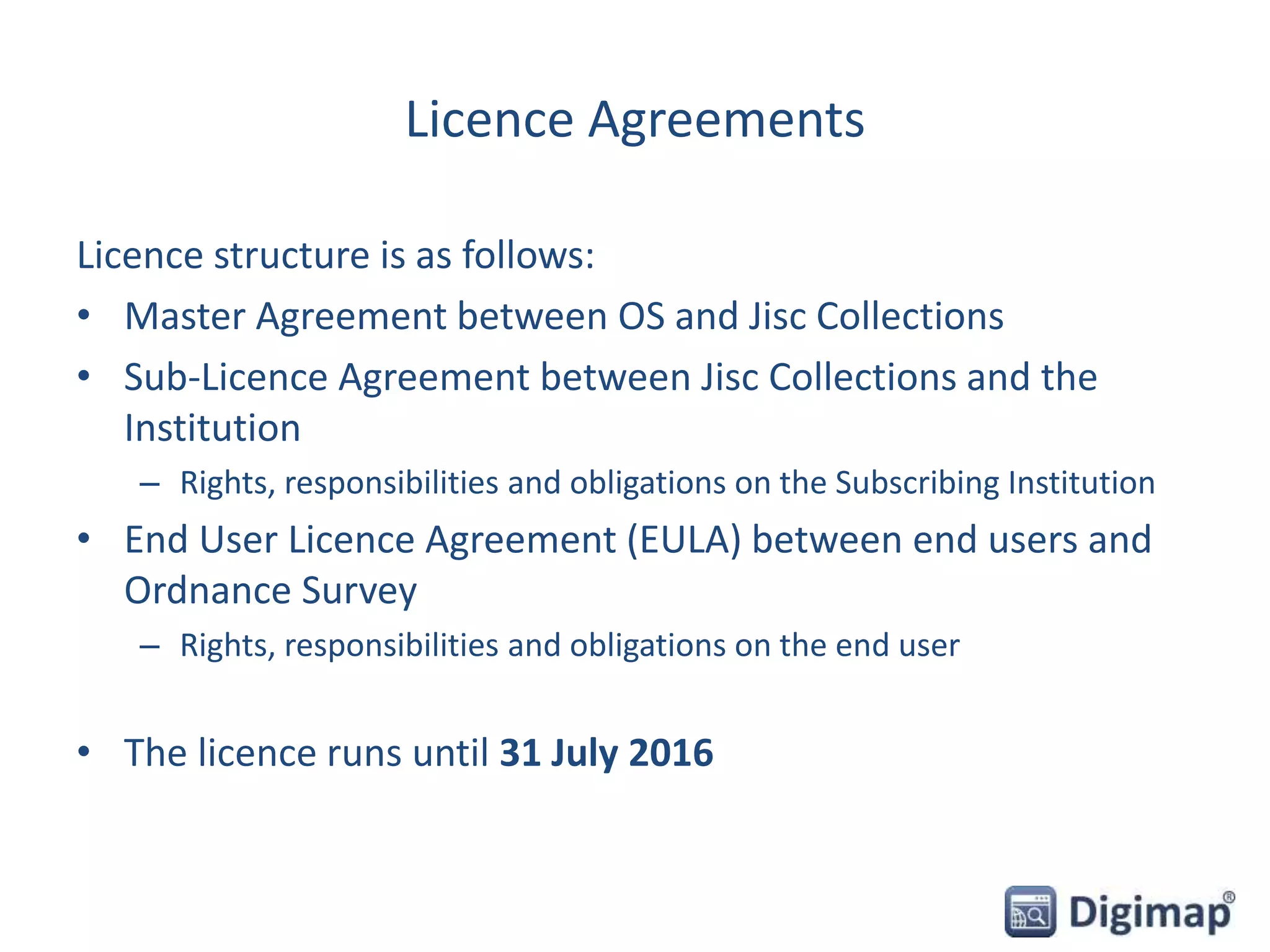
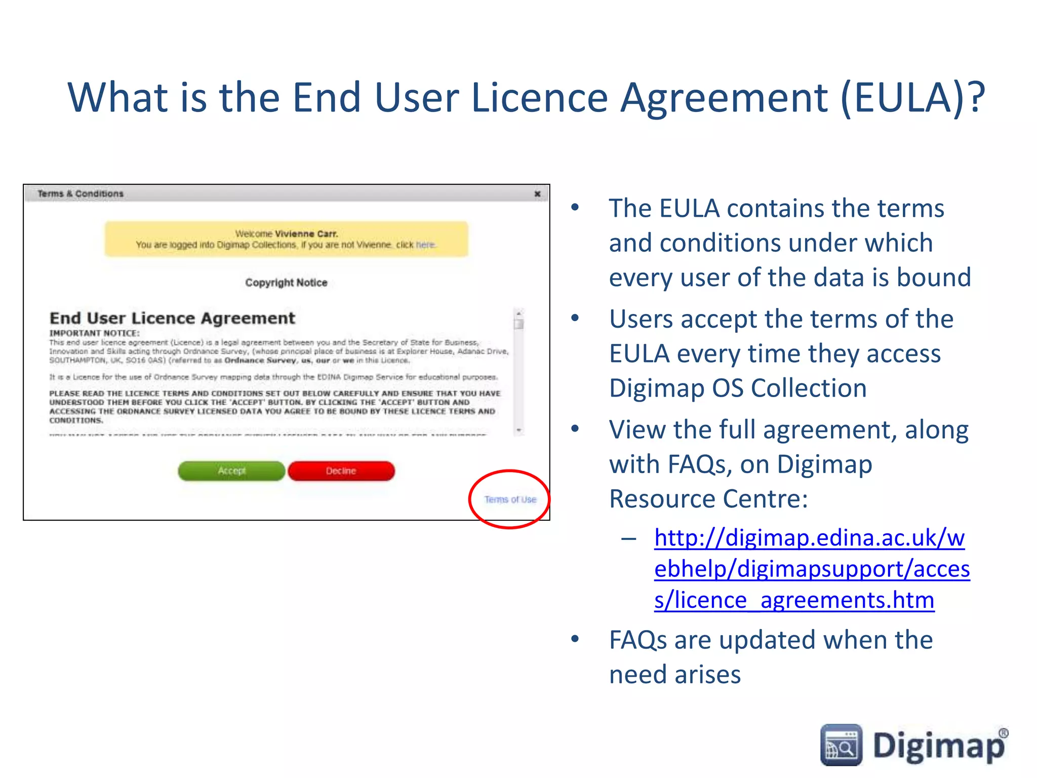
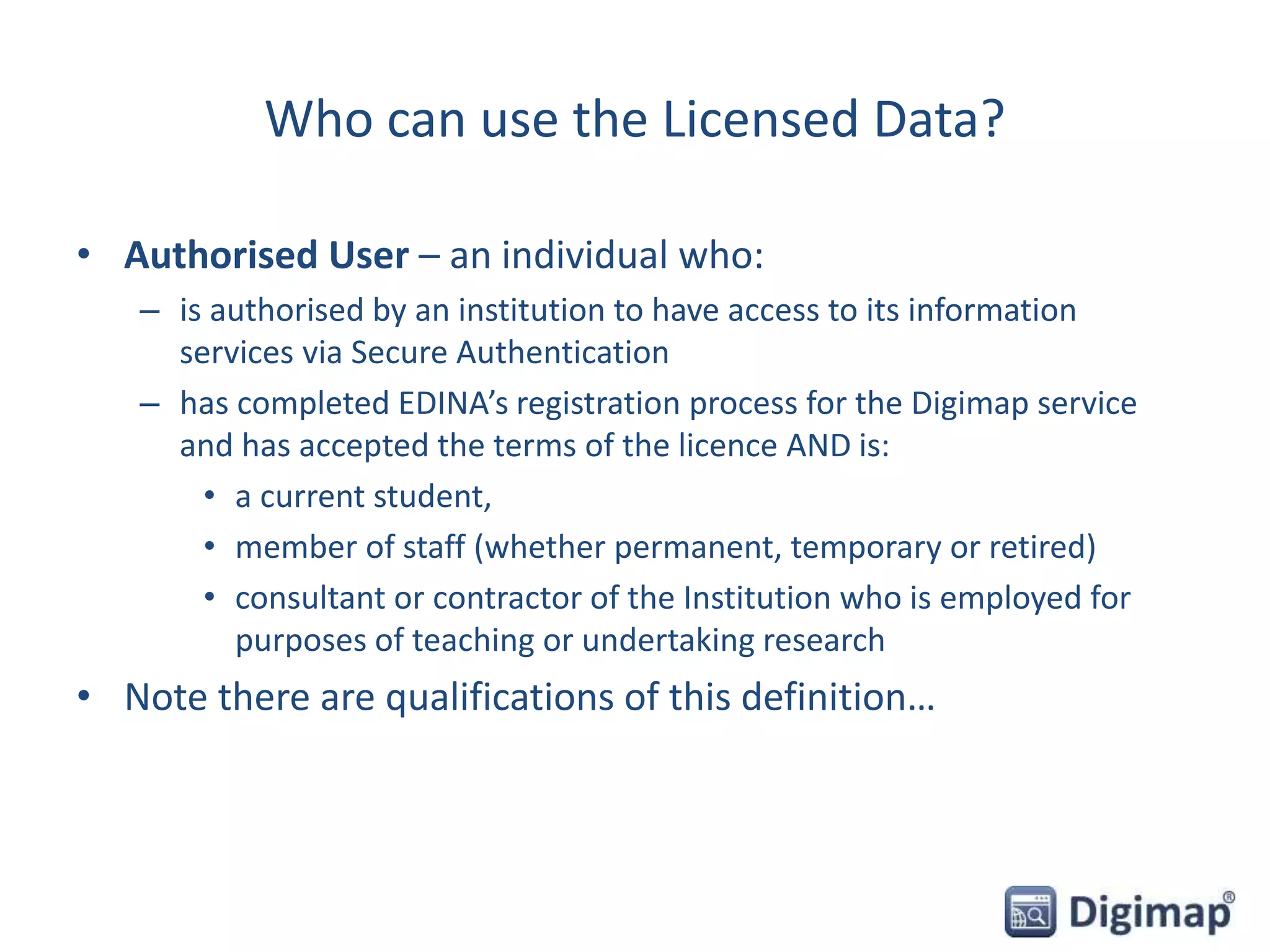
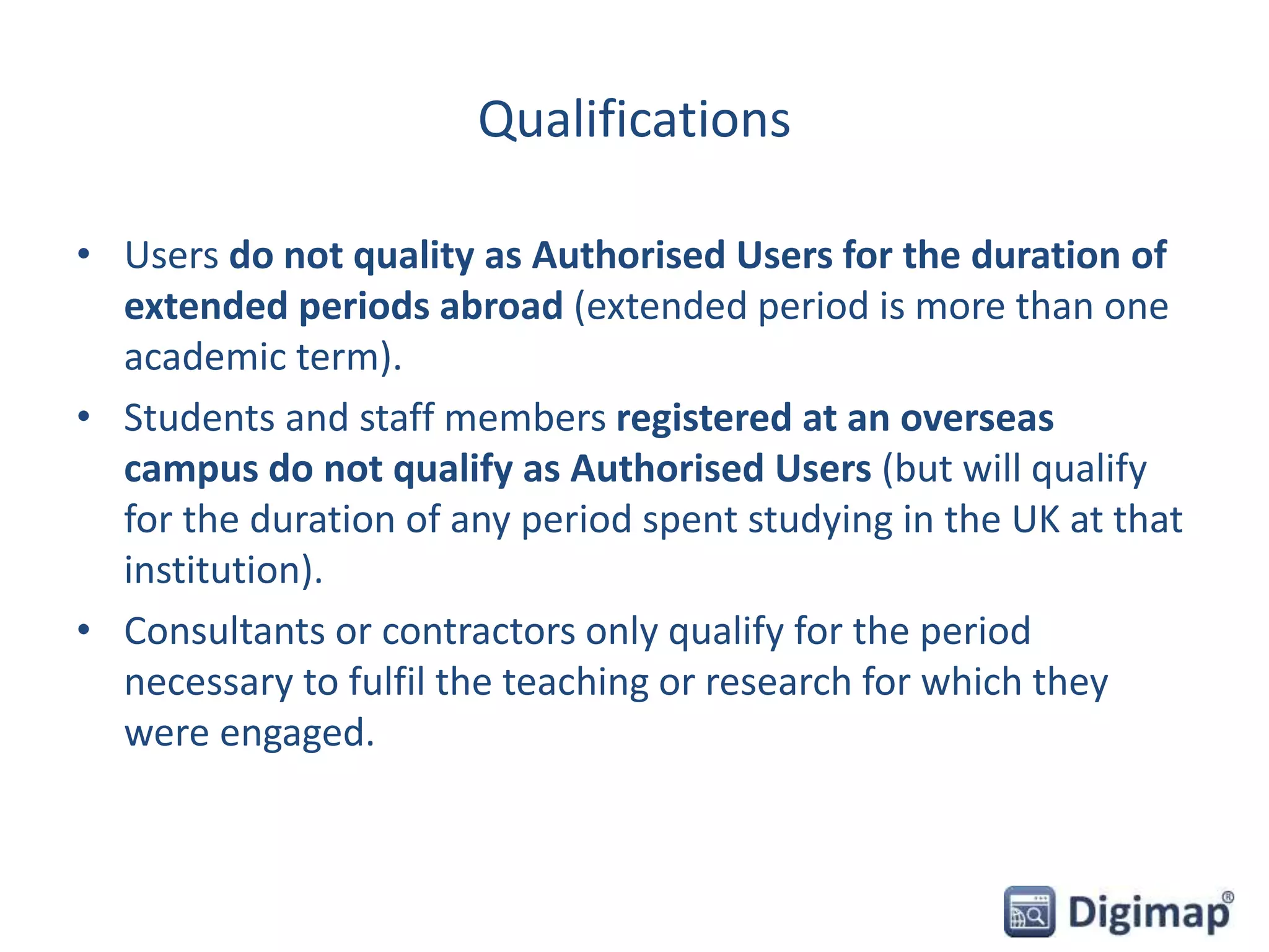
Digimap Ordnance Survey Collection
Copyright and Terms of use
1 April 2015
Emma Diffley, EDINA Geo User Support
• Licensed data and Open Data
• What is the End User Licence Agreement?
• Who can use the service?
• What can I do with the licensed data?
• Can I publish my maps on the web?
• Your questions
• Can I share data?
• What are the obligations and restrictions?
• Licence Termination
• Where can I get support with copyright questions?
• What do support staff need to do?
• Your questions
Content
Licensed Data versus OpenData
• All map data in Digimap OS Collection is created and supplied
by Ordnance Survey, Britain’s national mapping agency.
– Data only covers England, Scotland and Wales
– Northern Ireland has it’s own Ordnance Survey of Northern Ireland (also
known as Land and Property Services)
• Today covers the terms and conditions of Licensed Data.
• Some OS map products also available under the OS OpenData scheme.
– covered by a different licence, the OpenGovernment licence (OGL)
– Commercial use permitted
– http://www.nationalarchives.gov.uk/doc/open-government-licence/version/3/
• There is no overlap. Data are either covered by the Digimap
licence or the OpenGovernment Licence.
How do I know if it’s Licensed Data or OpenData?
• Roam service:
– Information is available in the Map
Information panel.
• Data Download service:
– Find out in Product Information boxes.
– Click on Info next to product name in Select
Data panel.
– Text file sent with each download detailing
which licence covers each data product.
Licence Agreements
Licence structure is as follows:
• Master Agreement between OS and Jisc Collections
• Sub-Licence Agreement between Jisc Collections and the
Institution
– Rights, responsibilities and obligations on the Subscribing Institution
• End User Licence Agreement (EULA) between end users and
Ordnance Survey
– Rights, responsibilities and obligations on the end user
• The licence runs until 31 July 2016
What is the End User Licence Agreement (EULA)?
• The EULA contains the terms
and conditions under which
every user of the data is bound
• Users accept the terms of the
EULA every time they access
Digimap OS Collection
• View the full agreement, along
with FAQs, on Digimap
Resource Centre:
– http://digimap.edina.ac.uk/w
ebhelp/digimapsupport/acces
s/licence_agreements.htm
• FAQs are updated when the
need arises
End User Licence Agreement Structure
• Legal agreement between the user and the Secretary of State
for Business, Innovation and Skills acting through Ordnance
Survey
• Allows access and use of the OS Licensed Data
• Solely for Educational Use or Limited Administrative Use
Who can use the Licensed Data?
• Authorised User – an individual who:
– is authorised by an institution to have access to its information
services via Secure Authentication
– has completed EDINA’s registration process for the Digimap service
and has accepted the terms of the licence AND is:
• a current student,
• member of staff (whether permanent, temporary or retired)
• consultant or contractor of the Institution who is employed for
purposes of teaching or undertaking research
• Note there are qualifications of this definition…
Qualifications
• Users do not quality as Authorised Users for the duration of
extended periods abroad (extended period is more than one
academic term).
• Students and staff members registered at an overseas
campus do not qualify as Authorised Users (but will qualify
for the duration of any period spent studying in the UK at that
institution).
• Consultants or contractors only qualify for the period
necessary to fulfil the teaching or research for which they
were engaged.
Some clarifications…
• Distance learning students only qualify as Authorised Users if
they are in the UK.
• Institutions must decide whether an individual is eligible for
“membership” status at that institution and issue
authorisation credentials accordingly.
• If your institution won’t vouch for you and issue you with
login details, you cannot become an Authorised User.
• You automatically cease to be an Authorised User when you
leave the UK.
End User Licence Agreement
• Structure
– Section 3 – Permitted Use
– Section 4 – Public Sector Data Sharing Rights
– Section 5 – Obligations/restrictions
– Section 6 – Ownership and Acknowledgment of Intellectual Property
Rights
– Section 8 – Automatic Termination of this licence
– Section 11 – Warranties and Limitations of Liability
– Appendix 1 - Definitions
Permitted uses
• Educational Use:
– teaching, learning, academic and sponsored research
and/or private study (includes distance learning from
within the UK, not from overseas)
• Limited Administrative Use:
– publish mapping images in promotional literature or web,
to show campus location/extent, event locations,
directions, promote subscription to Digimap service
– Incorporate mapping images in Youtube videos, for
demonstration or promotion of the service
What can I do with the Licensed Data?
Note: this is not exhaustive! Contact EDINA if in any doubt that
your proposed use of the OS data is permitted.
• Incorporate the data into academic works, presentation
materials, research works and teaching materials
• Publish maps in journals (no size limits specified); images
must be no larger than necessary to fulfil the purpose of
the map
• Display, view, interrogate, manipulate, modify, search and
otherwise use the Licensed Data
• Print copies of the Licensed Data
What can I do with the Licensed Data?
• Download and store data to any Device (EULA section 3.1)
• Supply copies of data to other authorised users (same and
different institutions) (EULA section 3.1.3)
• Supply copies of data to and receive data from PSMA (England
& Wales) or OSMA (Scotland) members (public sector
mapping agreements) (EULA section 4)
• Create a Navigational Product/Service as part of your course
provided the resultant service is only available to Authorised
Users for the current academic year (EULA section 3.4)
• Deposit electronic copies of maps in institutional repositories
(EULA section 3.2 and 3.3.5)
Can I publish my maps?
• Yes, on paper and in electronic form, including on the Web
• Provided mapping images are:
– in raster format only
– not georeferenced
– no larger than necessary
– include additional information
• And provided that:
– adequate steps taken to ensure third parties cannot access, use and
extract any OS data from such materials
• Social media
– you can post map images to Twitter and YouTube, but not Facebook.
• Books – require separate licence
Vector vs Raster
From the End User Licence Agreement definitions:
• Raster Format/Image
– means a mapping image made up of millions of individual pixels in a grid,
where the information stored within each pixel corresponds to the colour or
value of that pixel only.
– Otherwise known as a bitmap and/or a static map image, a raster image has
no 'intelligence‘, has no relation to the adjacent pixels.
• Vector Format/Image
– means a representation of the mapping made up of individual, geographic or
cartographic features comprising points, lines, areas and attributes,
(including cartographic text), relating to the real world.
– In contrast to a Raster Image, vector data is a flexible and intelligent form of
data which can be edited, modified and scaled without affecting the basic
feature itself.
Vector v Raster
Can I share data?
• Yes, you can share data with other Authorised Users
• You can share with users from your institution and other
institutions
• You are obliged to keep a written record of:
– the names and addresses of the receiving/supplying party
– what Ordnance Survey Licensed Data was received / supplied
– when the Ordnance Survey Licensed Data was received /supplied
– if asked, you will need to provide your records.
• Must NOT share Points of Interest data
Can I supply data to my research sponsors?
• Commercial sponsor
– can supply final report with any map images, not data (unless the
sponsor has a licence from OS for the same data for non-commercial
purposes)
• Government department
– can share data if they are members of Public Sector Mapping
Agreement/One Scotland Mapping Agreement (PSMA/OSMA) and are
licensed for same map products for same area
Your questions
What are your obligations?
• Keep login details secure and confidential, do not share
• Keep data secure and not publicly accessible
• Keep records of distribution
• Acknowledge use of the Licensed Data
Copyright Acknowledgement
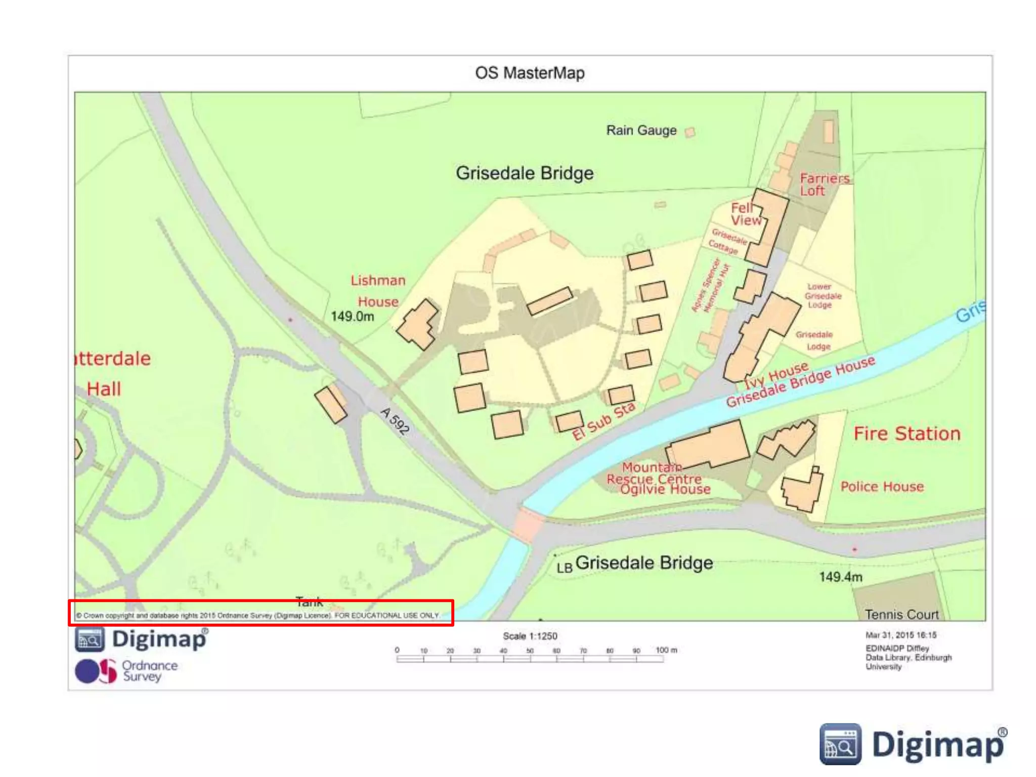
• Include acknowledgement in any display or publication:
– © Crown Copyright and database rights [insert date]. Ordnance Survey
(Digimap Licence).
• For example: © Crown Copyright and database rights 2015.
Ordnance Survey (Digimap Licence).
• NOTE: the above acknowledgement is automatically included
on all maps printed from Roam.
Citations
• Check your
download file for
citations text file
• Users can copy
and paste citation
information
• One entry for
each map product
• image shows OS
MasterMap
Topography
Citations
• Citation tool available
to create citations:
http://edina.ac.uk/projects/share
geo/Citation/Tool/services.html
What are the restrictions?
• No commercial use
• Check EULA sections 5.1 and 5.2 and their sub-clauses for
specific restrictions
• Users cannot create campus maps for web and mobile devices
that contain georeferenced data
• Cannot publish electronically maps that contain vector data
(e.g. Roam maps produced from vector data) that will be
accessible by non Authorised Users
• No use of OS data in mobile applications unless for
Educational Navigation Product/Service – restrictions apply.
Check section 3.4 of EULA
• No use of OS data where there is paid for or free advertising
Points of Interest data
• Additional
acknowledgement required:
– This material includes data
licensed from PointXŠ
Database Right/Copyright
[year of supply or date of
publication].
• Licence states:
– not to be used for any form
of sales, market research etc,
– or geocoding or correcting
any gazetteers or address
lists.
– cannot share with anyone.
Liability
• Users have unlimited liability for infringements of IPR,
whether
– by the user or
– by someone else as a result of the user’s failure to comply with the
obligations imposed by the licence
• Derived data:
– rules applying to Licensed Data also apply to data derived from
Licensed Data.
Termination of licence
• If licence is suspended, terminated, or expires:
– Must immediately cease accessing/using Digimap
– Within 7 days must destroy data in your possession
– Within 7 days must remove any Educational Navigation
Products/Services that you have developed
• Can retain:
– Printed copies of materials
– Printed screenshots of Educational Navigation Products/Services
– Mapping images embedded within electronic copies of materials or
educational navigation products (must be raster, not georeferenced)
For support staff – institution’s responsibilities
Data security requirements – outlined in Schedule 3 of OS Institutional Sub-Licence.
http://www.jisc-collections.ac.uk/Catalogue/Agreements/YearlyAgreements/2075
Also defines roles for Site Representative and Responsible Officers for Data Security.
In summary:
• Ensure no unauthorised access to the Digimap service takes place
• Ensure no unauthorised access to the Licensed Data takes place
• Nominate:
– a site representative who will be the main point of contact
– a Responsible Officer for Data Security and Deputy
• Communicate any actual or possible licence breaches to EDINA
• In the event of licence breaches, investigate and instigate disciplinary
procedures
Licence breaches
• Established set of procedures once an “incident” has been
identified. Includes timescales – must be resolved within 6
weeks.
• Details given in Security Appendix 3 of Sub-licence.
• User related or Institution related
– Example of User-related incident might be a single user sharing their
password with friends or sharing data they’ve downloaded with others
who are not Authorised Users
– Example of Institution-related incident might be a systematic failure of
the institution to terminate access once individuals cease to be
members of the institution (e.g. terminating graduate accounts)
Where can I get support?
• Full text and FAQs on licence agreements:
– http://digimap.edina.ac.uk/webhelp/digimapsupport/about.htm#access/l
icence_agreements.htm
• Digimap chat facility on all help pages
– Image of chat box to follow
• Our help desk:
– edina@ed.ac.uk
– 0131 650 3302
Your questions
Poll
Today’s webinar:
• I learnt something new
• I didn’t learn anything new
• Was a good use of my time
• Was a poor use of my time
• Other

Digimap Copyright webinar

  • 1.
    Digimap Ordnance SurveyCollection Copyright and Terms of use 1 April 2015 Emma Diffley, EDINA Geo User Support
  • 2.
    • Licensed dataand Open Data • What is the End User Licence Agreement? • Who can use the service? • What can I do with the licensed data? • Can I publish my maps on the web? • Your questions • Can I share data? • What are the obligations and restrictions? • Licence Termination • Where can I get support with copyright questions? • What do support staff need to do? • Your questions Content
  • 3.
    Licensed Data versusOpenData • All map data in Digimap OS Collection is created and supplied by Ordnance Survey, Britain’s national mapping agency. – Data only covers England, Scotland and Wales – Northern Ireland has it’s own Ordnance Survey of Northern Ireland (also known as Land and Property Services) • Today covers the terms and conditions of Licensed Data. • Some OS map products also available under the OS OpenData scheme. – covered by a different licence, the OpenGovernment licence (OGL) – Commercial use permitted – http://www.nationalarchives.gov.uk/doc/open-government-licence/version/3/ • There is no overlap. Data are either covered by the Digimap licence or the OpenGovernment Licence.
  • 4.
    How do Iknow if it’s Licensed Data or OpenData? • Roam service: – Information is available in the Map Information panel. • Data Download service: – Find out in Product Information boxes. – Click on Info next to product name in Select Data panel. – Text file sent with each download detailing which licence covers each data product.
  • 5.
    Licence Agreements Licence structureis as follows: • Master Agreement between OS and Jisc Collections • Sub-Licence Agreement between Jisc Collections and the Institution – Rights, responsibilities and obligations on the Subscribing Institution • End User Licence Agreement (EULA) between end users and Ordnance Survey – Rights, responsibilities and obligations on the end user • The licence runs until 31 July 2016
  • 6.
    What is theEnd User Licence Agreement (EULA)? • The EULA contains the terms and conditions under which every user of the data is bound • Users accept the terms of the EULA every time they access Digimap OS Collection • View the full agreement, along with FAQs, on Digimap Resource Centre: – http://digimap.edina.ac.uk/w ebhelp/digimapsupport/acces s/licence_agreements.htm • FAQs are updated when the need arises
  • 7.
    End User LicenceAgreement Structure • Legal agreement between the user and the Secretary of State for Business, Innovation and Skills acting through Ordnance Survey • Allows access and use of the OS Licensed Data • Solely for Educational Use or Limited Administrative Use
  • 8.
    Who can usethe Licensed Data? • Authorised User – an individual who: – is authorised by an institution to have access to its information services via Secure Authentication – has completed EDINA’s registration process for the Digimap service and has accepted the terms of the licence AND is: • a current student, • member of staff (whether permanent, temporary or retired) • consultant or contractor of the Institution who is employed for purposes of teaching or undertaking research • Note there are qualifications of this definition…
  • 9.
    Qualifications • Users donot quality as Authorised Users for the duration of extended periods abroad (extended period is more than one academic term). • Students and staff members registered at an overseas campus do not qualify as Authorised Users (but will qualify for the duration of any period spent studying in the UK at that institution). • Consultants or contractors only qualify for the period necessary to fulfil the teaching or research for which they were engaged.
  • 10.
    Some clarifications… • Distancelearning students only qualify as Authorised Users if they are in the UK. • Institutions must decide whether an individual is eligible for “membership” status at that institution and issue authorisation credentials accordingly. • If your institution won’t vouch for you and issue you with login details, you cannot become an Authorised User. • You automatically cease to be an Authorised User when you leave the UK.
  • 11.
    End User LicenceAgreement • Structure – Section 3 – Permitted Use – Section 4 – Public Sector Data Sharing Rights – Section 5 – Obligations/restrictions – Section 6 – Ownership and Acknowledgment of Intellectual Property Rights – Section 8 – Automatic Termination of this licence – Section 11 – Warranties and Limitations of Liability – Appendix 1 - Definitions
  • 12.
    Permitted uses • EducationalUse: – teaching, learning, academic and sponsored research and/or private study (includes distance learning from within the UK, not from overseas) • Limited Administrative Use: – publish mapping images in promotional literature or web, to show campus location/extent, event locations, directions, promote subscription to Digimap service – Incorporate mapping images in Youtube videos, for demonstration or promotion of the service
  • 13.
    What can Ido with the Licensed Data? Note: this is not exhaustive! Contact EDINA if in any doubt that your proposed use of the OS data is permitted. • Incorporate the data into academic works, presentation materials, research works and teaching materials • Publish maps in journals (no size limits specified); images must be no larger than necessary to fulfil the purpose of the map • Display, view, interrogate, manipulate, modify, search and otherwise use the Licensed Data • Print copies of the Licensed Data
  • 14.
    What can Ido with the Licensed Data? • Download and store data to any Device (EULA section 3.1) • Supply copies of data to other authorised users (same and different institutions) (EULA section 3.1.3) • Supply copies of data to and receive data from PSMA (England & Wales) or OSMA (Scotland) members (public sector mapping agreements) (EULA section 4) • Create a Navigational Product/Service as part of your course provided the resultant service is only available to Authorised Users for the current academic year (EULA section 3.4) • Deposit electronic copies of maps in institutional repositories (EULA section 3.2 and 3.3.5)
  • 15.
    Can I publishmy maps? • Yes, on paper and in electronic form, including on the Web • Provided mapping images are: – in raster format only – not georeferenced – no larger than necessary – include additional information • And provided that: – adequate steps taken to ensure third parties cannot access, use and extract any OS data from such materials • Social media – you can post map images to Twitter and YouTube, but not Facebook. • Books – require separate licence
  • 16.
    Vector vs Raster Fromthe End User Licence Agreement definitions: • Raster Format/Image – means a mapping image made up of millions of individual pixels in a grid, where the information stored within each pixel corresponds to the colour or value of that pixel only. – Otherwise known as a bitmap and/or a static map image, a raster image has no 'intelligence‘, has no relation to the adjacent pixels. • Vector Format/Image – means a representation of the mapping made up of individual, geographic or cartographic features comprising points, lines, areas and attributes, (including cartographic text), relating to the real world. – In contrast to a Raster Image, vector data is a flexible and intelligent form of data which can be edited, modified and scaled without affecting the basic feature itself.
  • 17.
  • 18.
    Can I sharedata? • Yes, you can share data with other Authorised Users • You can share with users from your institution and other institutions • You are obliged to keep a written record of: – the names and addresses of the receiving/supplying party – what Ordnance Survey Licensed Data was received / supplied – when the Ordnance Survey Licensed Data was received /supplied – if asked, you will need to provide your records. • Must NOT share Points of Interest data
  • 19.
    Can I supplydata to my research sponsors? • Commercial sponsor – can supply final report with any map images, not data (unless the sponsor has a licence from OS for the same data for non-commercial purposes) • Government department – can share data if they are members of Public Sector Mapping Agreement/One Scotland Mapping Agreement (PSMA/OSMA) and are licensed for same map products for same area
  • 20.
  • 21.
    What are yourobligations? • Keep login details secure and confidential, do not share • Keep data secure and not publicly accessible • Keep records of distribution • Acknowledge use of the Licensed Data
  • 22.
    Copyright Acknowledgement • Includeacknowledgement in any display or publication: – © Crown Copyright and database rights [insert date]. Ordnance Survey (Digimap Licence). • For example: © Crown Copyright and database rights 2015. Ordnance Survey (Digimap Licence). • NOTE: the above acknowledgement is automatically included on all maps printed from Roam.
  • 24.
    Citations • Check your downloadfile for citations text file • Users can copy and paste citation information • One entry for each map product • image shows OS MasterMap Topography
  • 25.
    Citations • Citation toolavailable to create citations: http://edina.ac.uk/projects/share geo/Citation/Tool/services.html
  • 26.
    What are therestrictions? • No commercial use • Check EULA sections 5.1 and 5.2 and their sub-clauses for specific restrictions • Users cannot create campus maps for web and mobile devices that contain georeferenced data • Cannot publish electronically maps that contain vector data (e.g. Roam maps produced from vector data) that will be accessible by non Authorised Users • No use of OS data in mobile applications unless for Educational Navigation Product/Service – restrictions apply. Check section 3.4 of EULA • No use of OS data where there is paid for or free advertising
  • 27.
    Points of Interestdata • Additional acknowledgement required: – This material includes data licensed from PointX© Database Right/Copyright [year of supply or date of publication]. • Licence states: – not to be used for any form of sales, market research etc, – or geocoding or correcting any gazetteers or address lists. – cannot share with anyone.
  • 28.
    Liability • Users haveunlimited liability for infringements of IPR, whether – by the user or – by someone else as a result of the user’s failure to comply with the obligations imposed by the licence • Derived data: – rules applying to Licensed Data also apply to data derived from Licensed Data.
  • 29.
    Termination of licence •If licence is suspended, terminated, or expires: – Must immediately cease accessing/using Digimap – Within 7 days must destroy data in your possession – Within 7 days must remove any Educational Navigation Products/Services that you have developed • Can retain: – Printed copies of materials – Printed screenshots of Educational Navigation Products/Services – Mapping images embedded within electronic copies of materials or educational navigation products (must be raster, not georeferenced)
  • 30.
    For support staff– institution’s responsibilities Data security requirements – outlined in Schedule 3 of OS Institutional Sub-Licence. http://www.jisc-collections.ac.uk/Catalogue/Agreements/YearlyAgreements/2075 Also defines roles for Site Representative and Responsible Officers for Data Security. In summary: • Ensure no unauthorised access to the Digimap service takes place • Ensure no unauthorised access to the Licensed Data takes place • Nominate: – a site representative who will be the main point of contact – a Responsible Officer for Data Security and Deputy • Communicate any actual or possible licence breaches to EDINA • In the event of licence breaches, investigate and instigate disciplinary procedures
  • 31.
    Licence breaches • Establishedset of procedures once an “incident” has been identified. Includes timescales – must be resolved within 6 weeks. • Details given in Security Appendix 3 of Sub-licence. • User related or Institution related – Example of User-related incident might be a single user sharing their password with friends or sharing data they’ve downloaded with others who are not Authorised Users – Example of Institution-related incident might be a systematic failure of the institution to terminate access once individuals cease to be members of the institution (e.g. terminating graduate accounts)
  • 32.
    Where can Iget support? • Full text and FAQs on licence agreements: – http://digimap.edina.ac.uk/webhelp/digimapsupport/about.htm#access/l icence_agreements.htm • Digimap chat facility on all help pages – Image of chat box to follow • Our help desk: – edina@ed.ac.uk – 0131 650 3302
  • 33.
  • 34.
    Poll Today’s webinar: • Ilearnt something new • I didn’t learn anything new • Was a good use of my time • Was a poor use of my time • Other