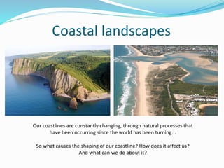
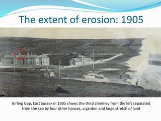
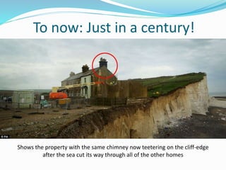
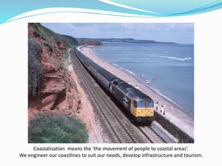
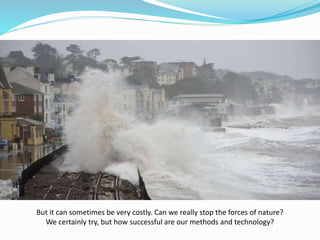
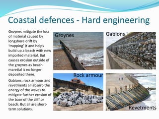
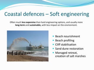
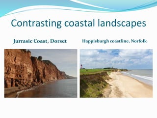
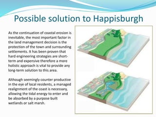
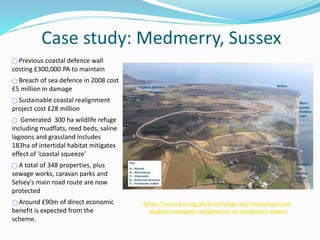
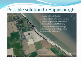
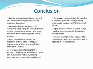
This document defines and describes various landforms and types of land areas on Earth. It explains that landforms are natural features of the Earth's surface and their arrangement is known as topography. Some key landforms discussed include mountains, hills, plateaus, plains, buttes, canyons, basins, valleys, islands, volcanoes, deserts, peninsulas, isthmuses, and continents.
The document provides information about river characteristics and landforms. It describes key features of drainage basins such as tributaries, watersheds and confluences. It explains the changes that occur along a river's long profile from upper to middle to lower course, including differences in gradient, erosion processes and landforms. Specific features of the upper course like interlocking spurs and waterfalls are also outlined. The formation of meanders and oxbow lakes in the middle course through erosion and deposition is detailed.
Running water is the primary agent of erosion on Earth's surface, though its role is limited in some glaciated and desert areas. Streams erode through processes like abrasion, attrition, solution, and hydraulic action. As they flow downhill, their kinetic energy is used to transport sediment in suspension, saltation, traction, or solution. When the stream's energy decreases, such as when entering flatter terrain, sediment is deposited in features like point bars, floodplains, levees, meanders, and deltas. Meanders may be cut off over time, forming oxbow lakes.
The document discusses the water cycle and distribution of water on Earth. Most (97%) of Earth's water is saltwater found in oceans. The remaining 3% is freshwater, with 76% bound up as ice in glaciers and ice sheets and less than 1% available for human use. Water is constantly circulated through the water cycle, driven by energy from the sun. In the cycle, water evaporates from oceans and land into the atmosphere, forms clouds, and falls back to the Earth's surface as precipitation like rain or snow.
A2 Geography Revision for Coastal Environments, subchapter 8.1 Waves Marine and Subaerial Processes. It is suitable for Year 13 Geography, Cambridge Examination in November 2016. It contains: key terms and definitions, a topic summary, sketches and descriptions, additional work (6 questions for testing your knowledge) and some suggested websites.
This document provides information on various topics related to oceanography. It discusses features of the ocean floor like the continental shelf and slope. It also covers properties of water such as its incompressibility and transparency to sound. Additionally, it summarizes the dissolved salts in seawater, how fresh water density varies with temperature, and temperature variations in the ocean. Further topics include salinity, density, freezing points, energy spectrums, sound speed, and ocean circulation forces like winds, Coriolis effect, and Ekman transport. The document also briefly outlines surface currents, deep water currents, upwelling and downwelling, and interactions between surface and deep sea currents.
This document discusses coastal erosion and mechanisms. It defines coastal terminology and describes the various agents that affect coastal erosion, including wind, waves, tides, and currents. It also examines the erosional and depositional landforms created by coastal processes, such as headlands, sea stacks, beaches, and barrier islands. Additionally, it covers the concepts of coastal erosion, longshore drift, and coastal deposition. The effects of coastal erosion are also addressed, as well as the importance of understanding coastal dynamics and implementing mitigation strategies to reduce erosion.
The document discusses the five main oceans of the world - the Pacific, Atlantic, Indian, Southern, and Arctic oceans. It provides data on the size and depths of each ocean, with the Pacific being the largest and the Mariana Trench in the Pacific being the deepest location at over 36,000 feet deep. Rivers are described as large bodies of fresh water that flow across land into seas or oceans, while lakes are bodies of fresh water surrounded by land.
This document summarizes the key concepts of weathering. It defines weathering as the physical, chemical, and biological breakdown of rocks due to atmospheric forces like wind, water, and glaciers. The three main types of weathering are physical, chemical, and biological. Physical weathering breaks rocks into smaller pieces through frost wedging, wetting and drying, exfoliation, and abrasion. Chemical weathering alters the composition of rocks through oxidation, hydration, carbonation, and acid rain. Biological weathering is caused by organisms like lichens. Over time, weathering and erosion form soil from broken down rock materials.
The document summarizes key aspects of the global water cycle and distribution of Earth's water resources. It describes that 97% of water is in oceans, with the remaining 3% being freshwater found mainly as ice (69%), groundwater (30%), and a very small amount (0.3%) in rivers and lakes. The hydrologic cycle involves processes like evaporation, transpiration, precipitation, runoff, infiltration and groundwater flow that continuously circulate and redistribute water around the planet. Different precipitation processes are also defined, along with other hydrologic cycle terms like interception, snowmelt, infiltration and evaporation.
Volcanoes form when lava reaches the Earth's surface. There are three main types of volcanoes: shield volcanoes which have a gentle slope, cinder cones made of blown cinder, and composite volcanoes with layers of cinder and lava. Mount Shasta is described as a composite volcano that has erupted on average every 800 years over the last 10,000 years. Diamond Head is an eroded cinder cone volcano formed by explosions when magma hit ocean water. Kohala is identified as an extinct shield volcano on Hawaii that has not erupted for 60,000 years.
- Climate change occurs on various timescales and is influenced by factors like solar activity, Earth's orbit, atmospheric composition and greenhouse gases, volcanic eruptions, and human activities like fossil fuel burning.
- Evidence from geology and fossils shows past climate changes, including intervals warmer than today and ice ages. The last ice age peaked around 20,000 years ago and glaciers have since retreated.
- Future climate is uncertain but computer models predict global warming and changing precipitation patterns if CO2 doubles from current levels due to feedbacks like ice-albedo and water vapor effects. Careful study of past and present helps understand complex climate system.
A2 CAMBRIDGE GEOGRAPHY: CHARACTERISTICS AND FORMATION OF COASTAL LANDFORMSGeorge Dumitrache
A2 CAMBRIDGE GEOGRAPHY: CHARACTERISTICS AND FORMATION OF COASTAL LANDFORMS. It contains: the formation of erosional landforms: cliffs and wave-cut platforms, caves, arches and stacks
Learners should be able to explain the formation of depositional landforms: beaches in cross section (profile) and plan, swash and drift aligned beaches, simple and compound spits, tombolos, offshore bars, barrier beaches, coastal dunes, tidal sedimentation in estuaries, coastal saltmarshes and mangroves, the role of sea level change in the formation of coastal landforms.
Physical Geography Lecture 17 - Oceans and Coastal Geomorphology 120716angelaorr
This document discusses various topics related to coastal geomorphology including ocean currents, tides, waves, and the landforms shaped by coastal processes. It describes how tides are caused by the gravitational pull of the moon and sun. Spring tides occur when these three bodies are aligned and produce the highest tides, while neap tides occur at right angles and have lower tides. Extreme tides over 15 meters occur in the Bay of Fundy. Waves are affected by factors like fetch, wind strength, and duration. Refraction disperses wave energy at headlands and concentrates it in bays, shaping distinctive coastal landforms. Human structures can disrupt sediment flows and cause shoreline erosion over time.
This document provides information on coastal geography topics including:
- The coast can be used for industry, transport, tourism, recreation, and nature conservation.
- Destructive waves are associated with storms and erosion while constructive waves are associated with deposition.
- Coastal weathering involves physical, chemical, and biological breakdown of rock, and erosion is the wearing away and transport of material.
- Waves erode coastlines through abrasion, hydraulic action, attrition, and solution. Headlands are eroded to form coastal landforms.
- Material is transported along beaches by swash and backwash. Beaches form through deposition by constructive waves.
- Spits, bars,
This document discusses various coastal landforms and processes. It begins with defining terms related to waves and wave action. It then explains processes of marine erosion and how they can shape cliff coastlines and form wave-cut platforms. It describes how waves can transport and deposit sediment. Landforms like spits, bars, and salt marshes are discussed along with their formation. Finally, it covers coral reef types and theories about their formation, and how sea level changes can impact coral reefs.
The document discusses the distribution of water on Earth. It notes that:
- 71% of the Earth's surface is covered in water, but 97% of that water is salty ocean water, leaving only 3% as freshwater.
- The major stores of freshwater are glaciers/ice (2.15%), groundwater (0.61%), and freshwater lakes (0.009%). Smaller amounts are found in the atmosphere, inland seas, soil moisture, and rivers.
- Water is distributed through the hydrologic cycle and, while it changes forms, the amount of water on Earth remains fairly constant over time as it is recycled.
There are four main types of landforms: mountains, plateaus, and plains. Mountains form through volcanism or faults in the earth's crust and are categorized as block, fold, residual, or volcanic mountains based on their formation. Plateaus are high plains that can be intermontane, piedmont, or continental based on their surrounding terrain. Plains form through deposition by rivers (alluvial), glaciers (glacial), seas (coastal), or uplift of continental shelves (structural).
This document contains summaries of several topics related to global freshwater resources:
1) It discusses groundwater hydrology, which is the study of water beneath the earth's surface, and how it is important for water supply, irrigation, and understanding water development and conservation.
2) Several sections summarize topics like the distribution of freshwater, depletion of resources, water salinization, and diseases caused by lack of access to clean water.
3) The document also covers policies like the Reduction of Lead in Drinking Water Act and how stormwater runoff is regulated through the National Pollutant Discharge Elimination System permit program to prevent pollution of surface waters.
This document defines various geographic and hydrologic terms. It describes different types of bodies of water like oceans, seas, gulfs, straits, rivers, streams, lakes, and reservoirs. It also defines landforms such as continents, islands, peninsulas, mountains, hills, valleys, plains, and deserts. Additionally, it explains geographic coordinate systems and important lines like the equator, prime meridian, latitude and longitude.
Singapore obtains its water supply from four main sources, known as the "four national taps": local catchment water, imported water from Malaysia, reclaimed water (NEWater), and desalinated water. Half of Singapore's land is used for catchment areas to collect rainwater, while the rest is highly urbanized. To ensure water sustainability, Singapore employs strategies like pricing water to reduce demand, educating the public on conservation, and developing alternative sources like NEWater. Singapore also imports water from Malaysia under long-term agreements and implements a reservoir integration scheme to maximize catchment capacity.
The document discusses various coastal landforms created by erosion and deposition processes along shorelines. It describes landforms such as headlands and bays, cliffs and wave-cut platforms, caves, arches, stacks, and stumps which are formed by coastal erosion. Beaches and spits are landforms created by coastal deposition, with beaches forming in sheltered areas between high and low tide lines, and spits forming as narrow ridges projecting from the coast due to longshore drift depositing materials.
This document provides an overview of karst topography and the geological processes involved in its formation. Karst topography is shaped by the dissolution of soluble bedrock like limestone by mildly acidic water. This causes features like caves, sinkholes, stalactites, stalagmites, and disappearing streams. The water dissolves along fractures in the bedrock, enlarging openings underground and forming drainage systems. Over thousands of years, this process creates characteristic karst landforms.
There are three major fossil fuels: coal, oil, and natural gas. Coal forms from peat deposits over millions of years, progressing through lignite, bituminous coal, and finally anthracite. Coal is ground up and pumped through pipelines to power plants. Oil forms from the remains of tiny sea creatures and is refined for use in vehicles and other machinery. Natural gas forms near oil deposits and is used for heating and electricity generation.
Here are the answers to the questions:
1. A convection cell is a circular flow pattern caused by heating and cooling of the atmosphere or ocean.
2. In the Southern Hemisphere, currents get deflected to the left due to the Coriolis effect.
3. An Ekman spiral occurs in the upper 100 meters or less of the ocean.
4. Surface currents are created by wind stress and friction at the air-sea interface.
5. A gyre is a large system of circular ocean currents, typically thousands of kilometers across.
6. During an El Nino, upwelling of cold, nutrient-rich water is reduced along the coasts of the Americas.
7. The
An oxbow lake is a crescent-shaped lake that forms when a meander loop in a river is cut off from the main channel. Over time, erosion and deposition cause the neck of the meander loop to narrow until it disappears completely, separating the loop from the river and leaving behind a free-standing crescent-shaped body of water known as an oxbow lake.
The document discusses coastal erosion issues in Happisburgh, England. It notes that over 250m of land was lost between 1600-1850, and 125m was lost between 1992-2007 at a rate of around 8m/year. The cliffs are comprised of glacial sands and clays that are easily eroded by the sea and saturated by rainwater. Coastal defenses could worsen the situation by disrupting sediment flows, while rising seas and stronger storms from climate change also increase erosion risks. The rapid erosion is negatively impacting the local community and environment through lost homes and infrastructure as well as valuable farmland.
Coastal areas face problems of erosion and flooding due to rising sea levels and increased storm activity. This threatens homes, businesses and tourism. Coastal defenses use hard engineering like seawalls and groynes, or soft engineering like beach nourishment and managed retreat, to protect coastlines. However, all methods have disadvantages such as visual impacts or increasing erosion elsewhere. Coastal resorts also struggle with declining visitor numbers from overseas competition and require solutions like improving attractions to revitalize their economies.
A2 Geography Revision for Coastal Environments, subchapter 8.4 Sustainable Management of Coasts. It is suitable for Year 13 Geography, Cambridge Examination in November 2016. It contains: key terms and definitions, a topic summary, sketches and descriptions, additional work (6 questions for testing your knowledge) and some suggested websites.
A brief pictorial history of Noosa Main Beach and Estuary reviewing coastal management from first nations through first settlement to current day - with a brief overview of coastal management theory.
Sources include Nancy Cato's Noosa Story and other publications featured in slides.
The factors that have led to the Holderness coast suffering from erosion and the potential costs of this eroding coastline. Perfect for AS Level Geography.
presentation was provided by Prof W.U Chandrasekara
Department of Zoology and Environmental Management
For Coastal and Marine resource management course
GEOGRAPHY IGCSE: THE HOLDERNESS COASTLINE. It contains: main facts, eroding coast Europe, long shore drift, features of the Holderness coastline, management, coastline defense.
Advanced technologies for costal protectionLINGA SAI TEJA
This document discusses various advanced technologies for coastal protection in India. It introduces the importance of protecting India's long coastline from flooding and erosion. It then describes different methods of coastal protection including sea walls, breakwaters, groins, gabions, revetments, bulkheads, and beach nourishment. It provides details on each method and examples of their use. The document emphasizes the importance of coastal protection for safety, economic, and environmental reasons. It notes that development and habitat loss threaten coastlines and that protection methods should consider social, economic and environmental impacts.
1. The document summarizes case studies on different coastal ecosystems and locations, including Oxwich Bay in Wales, Ban Don Bay in Thailand, and the 1953 North Sea storm surge.
2. It also discusses short term changes to sea levels from the 1953 storm surge, which caused major flooding and loss of life in eastern England. Wind and low pressure raised sea levels over 2 meters.
3. The final section examines tourism and recreation on the Dorset coast of England, noting its economic importance but also environmental impacts, and the management strategies employed to mitigate conflicts between different user groups.
The Holderness Coastline in eastern England has some of the fastest erosion rates in Europe, averaging around 2 meters per year. The geology of the area, consisting of soft glacial till deposited over 12,000 years ago, is highly erodible and is being rapidly worn away by the sea. The village of Mappleton provides a case study of coastal management efforts, where rock groynes were constructed in 1991 to reduce erosion, but have shifted the erosion problem further south. Spurn Point at the southern end of the coastline consists of material deposited by longshore drift and acts as a barrier, though its position is now fixed through artificial defenses.
Retaining walls are an integral part of any sea facing structure or structures which contain single or multiple basements. The PPT gives a general idea about retaining walls and also focuses on a case study of the retaining wall along the Worli Seaface in Mumbai, India.
The document discusses coastal erosion at Dunwich and Aldeburgh in Suffolk, England. Dunwich has experienced significant erosion, with most of the once-thriving port town now underwater as a result of storms and sea level rise. Rates of erosion average 1 meter per year. In contrast, coastal management efforts like groynes and sea walls have been implemented to protect Aldeburgh from similar erosion problems. The reasons for implementing protection at Aldeburgh but not Dunwich are also examined.
Beach nourishment involves replacing sand lost to erosion from external sources to widen beaches. It reduces storm damage by dissipating wave energy and protects structures. Nourishment must be repeated as it doesn't stop erosion forces. Sand used must match native beaches in size and texture. Nourishment widens beaches for recreation while providing flood and erosion protection. It is expensive to implement but supports local economies. Alternative stabilization methods include hard structures or soft techniques but don't fully restore eroded beaches like nourishment does.
The Gold Coast shoreline management plan was needed to address beach erosion caused by groynes blocking longshore sediment transport and exacerbated by storms. The plan used a combination of "soft" engineering solutions like beach nourishment through the Tweed Sand Bypass project and dune stabilization, and "hard" engineering like an artificial reef at Narrowneck, to widen beaches and protect coastal development while maintaining recreational opportunities like surfing. Monitoring indicates the strategies have been successful in maintaining beach widths and improving habitats.
A multi-purpose artificial surfing reef is an innovation that provides multiple benefits, particularly coastal protection,improved marine ecology, sheltered water inshore for safer swimming and recreation.
Coastal erosion is a major problem for Grand Bahama's economy and infrastructure due to sea level rise and hurricanes. Hard engineering structures like sea walls, groynes and breakwaters have been used to protect settlements, roads and tourism resorts, but can disrupt sediment flows and cause erosion issues further down the coast. Softer techniques like beach replenishment, gabions and dune vegetation have also been tried with mixed results. While protection is needed, coastal managers must consider both economic and environmental impacts.
Realities of Beach Restoration in QuogueQuogueBeaches
Beach restoration using beach compatible sand from a suitable off-shore source is a logical extension of the existing Village Coastal Management Program that should be undertaken after issuance of the appropriate permits and consensus in the community.
The Holderness Coastline of England suffers from the highest rates of coastal erosion in Europe due to its soft, easily eroded geology and exposure to strong winds and waves from the North Sea. Several villages have been lost to coastal erosion over the centuries. While some areas implement hard coastal defenses like seawalls and rock armor to combat erosion, these strategies are costly to maintain and can worsen erosion elsewhere down the coast. Integrated coastal zone management is now sought to balance protection of infrastructure with the natural shoreline processes.
Main Java[All of the Base Concepts}.docxadhitya5119
This is part 1 of my Java Learning Journey. This Contains Custom methods, classes, constructors, packages, multithreading , try- catch block, finally block and more.
This presentation includes basic of PCOS their pathology and treatment and also Ayurveda correlation of PCOS and Ayurvedic line of treatment mentioned in classics.
Executive Directors Chat Leveraging AI for Diversity, Equity, and InclusionTechSoup
Let’s explore the intersection of technology and equity in the final session of our DEI series. Discover how AI tools, like ChatGPT, can be used to support and enhance your nonprofit's DEI initiatives. Participants will gain insights into practical AI applications and get tips for leveraging technology to advance their DEI goals.
The simplified electron and muon model, Oscillating Spacetime: The Foundation...RitikBhardwaj56
Discover the Simplified Electron and Muon Model: A New Wave-Based Approach to Understanding Particles delves into a groundbreaking theory that presents electrons and muons as rotating soliton waves within oscillating spacetime. Geared towards students, researchers, and science buffs, this book breaks down complex ideas into simple explanations. It covers topics such as electron waves, temporal dynamics, and the implications of this model on particle physics. With clear illustrations and easy-to-follow explanations, readers will gain a new outlook on the universe's fundamental nature.
How to Add Chatter in the odoo 17 ERP ModuleCeline George
In Odoo, the chatter is like a chat tool that helps you work together on records. You can leave notes and track things, making it easier to talk with your team and partners. Inside chatter, all communication history, activity, and changes will be displayed.
हिंदी वर्णमाला पीपीटी, hindi alphabet PPT presentation, hindi varnamala PPT, Hindi Varnamala pdf, हिंदी स्वर, हिंदी व्यंजन, sikhiye hindi varnmala, dr. mulla adam ali, hindi language and literature, hindi alphabet with drawing, hindi alphabet pdf, hindi varnamala for childrens, hindi language, hindi varnamala practice for kids, https://www.drmullaadamali.com
A workshop hosted by the South African Journal of Science aimed at postgraduate students and early career researchers with little or no experience in writing and publishing journal articles.
ISO/IEC 27001, ISO/IEC 42001, and GDPR: Best Practices for Implementation and...PECB
Denis is a dynamic and results-driven Chief Information Officer (CIO) with a distinguished career spanning information systems analysis and technical project management. With a proven track record of spearheading the design and delivery of cutting-edge Information Management solutions, he has consistently elevated business operations, streamlined reporting functions, and maximized process efficiency.
Certified as an ISO/IEC 27001: Information Security Management Systems (ISMS) Lead Implementer, Data Protection Officer, and Cyber Risks Analyst, Denis brings a heightened focus on data security, privacy, and cyber resilience to every endeavor.
His expertise extends across a diverse spectrum of reporting, database, and web development applications, underpinned by an exceptional grasp of data storage and virtualization technologies. His proficiency in application testing, database administration, and data cleansing ensures seamless execution of complex projects.
What sets Denis apart is his comprehensive understanding of Business and Systems Analysis technologies, honed through involvement in all phases of the Software Development Lifecycle (SDLC). From meticulous requirements gathering to precise analysis, innovative design, rigorous development, thorough testing, and successful implementation, he has consistently delivered exceptional results.
Throughout his career, he has taken on multifaceted roles, from leading technical project management teams to owning solutions that drive operational excellence. His conscientious and proactive approach is unwavering, whether he is working independently or collaboratively within a team. His ability to connect with colleagues on a personal level underscores his commitment to fostering a harmonious and productive workplace environment.
Date: May 29, 2024
Tags: Information Security, ISO/IEC 27001, ISO/IEC 42001, Artificial Intelligence, GDPR
-------------------------------------------------------------------------------
Find out more about ISO training and certification services
Training: ISO/IEC 27001 Information Security Management System - EN | PECB
ISO/IEC 42001 Artificial Intelligence Management System - EN | PECB
General Data Protection Regulation (GDPR) - Training Courses - EN | PECB
Webinars: https://pecb.com/webinars
Article: https://pecb.com/article
-------------------------------------------------------------------------------
For more information about PECB:
Website: https://pecb.com/
LinkedIn: https://www.linkedin.com/company/pecb/
Facebook: https://www.facebook.com/PECBInternational/
Slideshare: http://www.slideshare.net/PECBCERTIFICATION
it describes the bony anatomy including the femoral head , acetabulum, labrum . also discusses the capsule , ligaments . muscle that act on the hip joint and the range of motion are outlined. factors affecting hip joint stability and weight transmission through the joint are summarized.
Macroeconomics- Movie Location
This will be used as part of your Personal Professional Portfolio once graded.
Objective:
Prepare a presentation or a paper using research, basic comparative analysis, data organization and application of economic information. You will make an informed assessment of an economic climate outside of the United States to accomplish an entertainment industry objective.
1. Coastal landscapes
Our coastlines are constantly changing, through natural processes that
have been occurring since the world has been turning...
So what causes the shaping of our coastline? How does it affect us?
And what can we do about it?
2. Coastal erosion
Destructive waves,
strong swash/backwash
and tidal currents cause:
Hydraulic action
Abrasion
Attrition
Solution
The sea shapes the coastal landscape.
Coastal erosion is the wearing away and
breaking up of rock along the coast.
3. Birling Gap, East Sussex in 1905 shows the third chimney from the left separated
from the sea by four other houses, a garden and large stretch of land
The extent of erosion: 1905
4. To now: Just in a century!
Shows the property with the same chimney now teetering on the cliff-edge
after the sea cut its way through all of the other homes
5. Coastalisation means the ‘the movement of people to coastal areas’.
We engineer our coastlines to suit our needs, develop infrastructure and tourism.
6. But it can sometimes be very costly. Can we really stop the forces of nature?
We certainly try, but how successful are our methods and technology?
7. Coastal defences - Hard engineering
Porthleven, Cornwall, during a storm.
Sea walls:
Permanent stone or brick
structures built to protect
settlements or cliff bases
from erosion. Although
seemingly effective they do
not absorb the waves
energy, rather reflects it
actually causing beach
erosion, sometimes
undercutting the structure.
Tend to be expensive, short-term options that may also have a high impact
on the landscape or environment and considered to be unsustainable.
8. Coastal defences - Hard engineering
Groynes mitigate the loss
of material caused by
longshore drift by
‘trapping’ it and helps
build up a beach with new
imported material. But
causes erosion outside of
the groynes as beach
maretial is no longer
deposited there.
Gabions, rock armour and
revetments all absorb the
energy of the waves to
mitigate further erosion of
the base of the cliff or
beach. But all are short-
term solutions.
Groynes
Rock armour
Gabions
Revetments
9. Coastal defences – Soft engineering
Beach nourishment
Beach profiling
Cliff stabilisation
Sand dune restoration
Managed retreat,
creation of salt marshes
Often much less expensive than hard engineering options, and usually more
long-term and sustainable, with less impact on the environment.
10. Managed retreats – Most sustainable
Advantages
Land becomes a marsh, slowing
waves and reducing erosion
Creates new habitats and
promotes biodiversity
Good for recreation, walking and
bird watching
Disadvantages
Arable/development land is lost
Can be costly depending on scale
of human resettlement
Managed realignment involves altering the location of the line of defence,
to provide a more sustainable position to manage flood and erosion risks.
13. Contrasting coastal landscapes
Jurrasic Coast, Dorset Happisburgh coastline, Norfolk
Triassic, Jurassic and Cretaceous
period resistant sedimentary rock of
red sandstone, limestone, clay and
shale cliffs
71 layers rich in fossils documenting
185 million years of plant and animal
fossilisation
Tall, vertical cliffs with highest point
191 m above sea level making it
highest point along South west coast
18 mile barrier beach with intertidal
lagoon important to biodiversity
https://en.wikipedia.org/wiki/Jurassic_Coast
Very low lying coastline approximately
only 10 m tall cliffs to sea level.
Cliffs are composed of glacial drift
deposited from a retreating ice sheet
425,000 years ago. The beds below
the glacial till comprise muds, sands
and gravel.
The cliffs are unconsolidated material
therefore non-resistant and easily
eroded.
http://www.northfolk.org.uk/geology/happisburg
h.html
14. Case study: Happisburgh
In less than a decade it is clear from these
aerial photos that the rate of erosion along
this part of the coastline has been
extensive. Various hard engineering
strategies have been constructed to
mitigate the effects of coastal erosion and
although they may have seemingly slowed
down the process, it certainly did not stop
the forces of nature and erosion continued
regardless.
The red line in the 1998 photo indicates the
actual coastline in the 2007 photo. Many
metres of land have been lost, as well as the
houses that were once situated on it.
Erosion continued...
https://www.pinterest.com/pin/545920786062323545/
15. Case study: Happisburgh
Happisburgh. 26 Feb 2014. Photo: Mike Page
http://www.edp24.co.uk/news/environment/aerial-photos-of-happisburgh-
spanning-13-years-show-ravages-of-coastal-erosion-1-3370564
Extract:
Relentless coastal erosion has
seen many metres of land lost to
the North Sea’s ravages...
Vulnerable homes have been
demolished ahead of their
inevitable tumble down the
crumbling cliffs, and their
occupants have retreated
inland... Happisburgh suffered
because it was the “soft
underbelly,” sandwiched
between two sets of hard sea
defences. But he added: “Hard
defences only reduce risk. In the
end you cannot stop the sea. We
have to learn how to manage our
way through the whole problem
of climate change.”
16. Case study: Happisburgh
Happisburgh in 1996, 2006 and 2012 during which time it has lost a number of sea front properties (copyright Mike Page)
https://blog.geographydirections.com/2013/11/01/adapting-to-coastal-change-understanding-different-points-of-view-in-coastal-erosion-management/
17. Possible solution to Happisburgh
As the continuation of coastal erosion is
inevitable, the most important factor in
the land management decision is the
protection of the town and surrounding
settlements. It has been proven that
hard engineering strategies are short-
term and expensive therefore a more
holistic approach is vital to provide any
long-term solution to this area.
Although seemingly counter productive
in the eye of local residents, a managed
realignment of the coast is necessary,
allowing the tidal energy to enter and
be absorbed by a purpose built
wetlands or salt marsh.
18. Case study: Medmerry, Sussex
https://www.ice.org.uk/knowledge-and-resources/case-
studies/managed-realignment-at-medmerry-sussex
⃝ Previous coastal defence wall
costing £300,000 PA to maintain
⃝ Breach of sea defence in 2008 cost
£5 million in damage
⃝ Sustainable coastal realignment
project cost £28 million
⃝ Generated 300 ha wildlife refuge
including mudflats, reed beds, saline
lagoons and grassland includes
183ha of intertidal habitat mitigates
effect of ‘coastal squeeze’
⃝ A total of 348 properties, plus
sewage works, caravan parks and
Selsey's main road route are now
protected
⃝ Around £90m of direct economic
benefit is expected from the
scheme.
19. Possible solution to Happisburgh
⃝ Eroding cliffs only 7 m tall
⃝ Settlement only 10 m above sea level
⃝ Extensive agricultural land suitable
wetlands site similar to Medmerry
⃝ Excavated material ideal for large
wetland perimeter providing a viable
sea defence for settlement
20. Conclusion
⃝ Coastal landscapes are diverse, formed
of a variety of rock types with variable
resistance to erosion.
⃝ We create human settlements in
vulnerable areas along the coast, therefore
require engineering strategies to protect
our towns from storm surge and coastal
erosion.
⃝ Hard engineering strategies are
expensive to build and need regular
maintenance which is costly and only
short-term solutions
⃝ Low laying coastal areas prone to
erosion or flooding are ideal sites to create
salt marshes and wetlands, creating
protected areas to promote biodiversity.
⃝ A managed realignment of the coastline
is a holistic approach to safeguarding
settlements, working ‘with’ the forces of
nature.
⃝ Agricultural land more viable to realign
coastline minimising costs of relocating
local residents.
⃝ Created wildlife habitats also good for
recreation activities and tourism as well as
boosting the local economy.