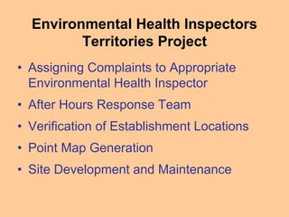
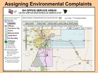
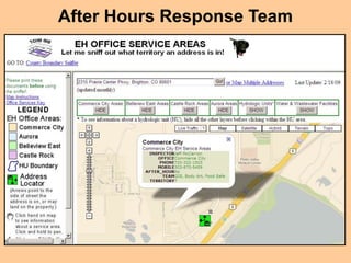
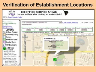
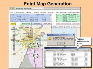
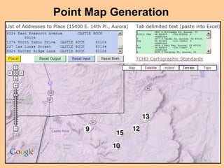
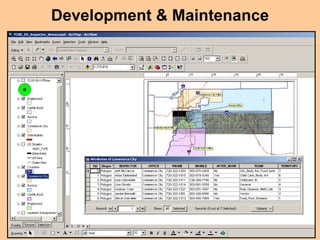
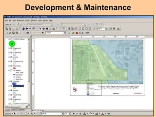
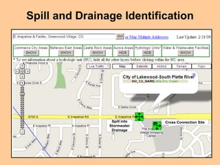
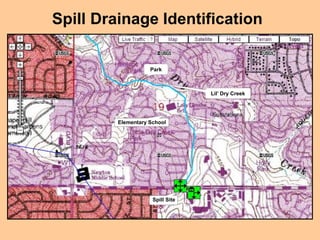
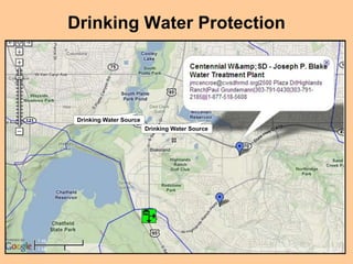
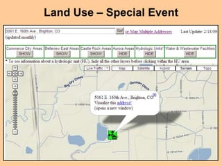
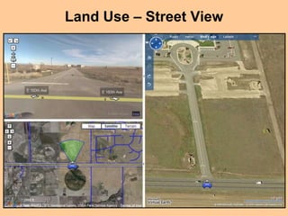
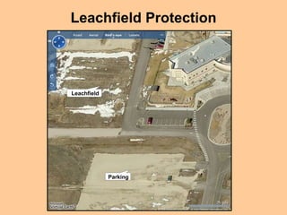
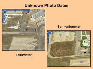
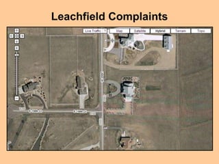
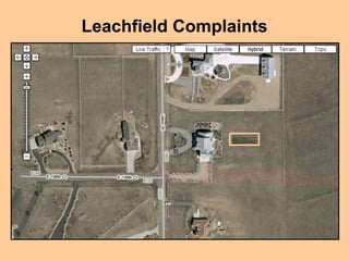
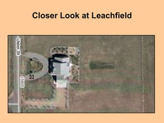
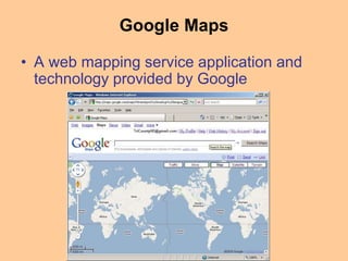
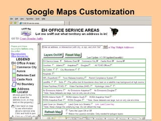
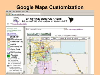
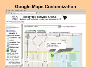
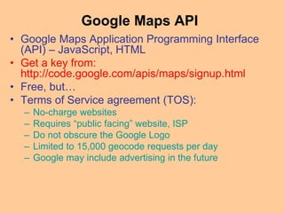
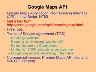
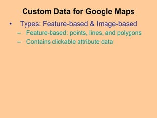
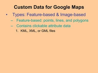
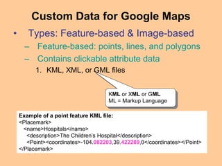
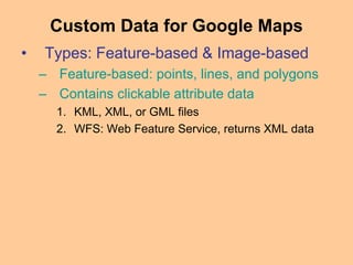
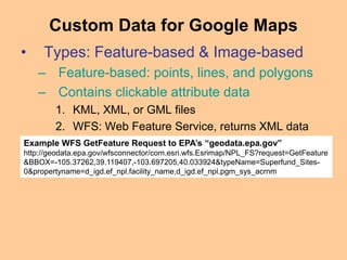
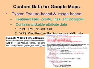
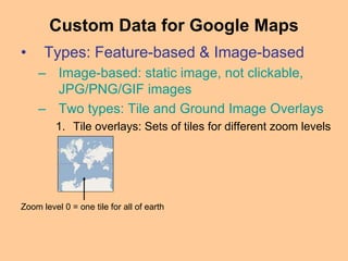
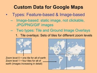
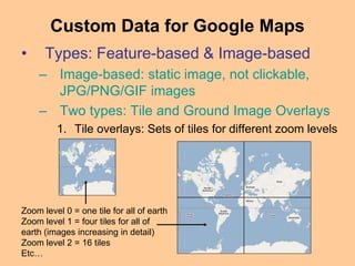
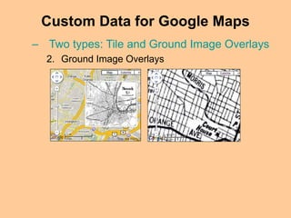
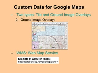
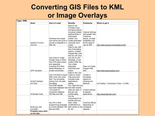
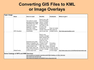
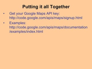
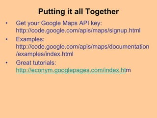
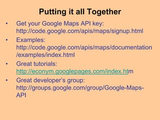
TRI-COUNTY HEALTH DEPARTMENT
Google Maps Internet Mapping Tools
The TCHD “Sniffer”
CHUG, May 7th, 2009
Hope Dalton, Water Specialist
Lara Juliusson, GIS Coordinator
Jeff McCarron, Environmental Health Specialist II
Presentation Outline
• Environmental Health Inspectors
Territories Project
– Jeff McCarron
• Specialized Uses
– Hope Dalton
• Google Maps Application Programming
Interface & Data Integration
– Lara Juliusson
Environmental Health Inspectors
Territories Project
• Assigning Complaints to Appropriate
Environmental Health Inspector
• After Hours Response Team
• Verification of Establishment Locations
• Point Map Generation
• Site Development and Maintenance
Assigning Environmental Complaints
After Hours Response Team
Verification of Establishment Locations
Point Map Generation
Table of
Addresses in
Excel
Point Map Generation
Development & Maintenance
Specialized Uses
• Spill and Drainage Identification
• Drinking Water Protection
• Land Use Reviews
• Leachfield (ISDS Absorption Area)
Complaints
Spill and Drainage Identification
Cross Connection Site
Spill into Stormwater
Drainage
Cross Connection SiteSpill into
Stormwater
Drainage
Spill Drainage Identification
Elementary School
Park
Lil’ Dry Creek
Spill Site
Drinking Water Protection
Drinking Water Source
Land Use – Special Event
Land Use – Street View
Leachfield Protection
Leachfield
Parking
Unknown Photo Dates
Fall/Winter
Spring/Summer
Leachfield Complaints
Closer Look at Leachfield
Google Maps Application Programming
Interface & Data Integration
• Google Maps Overview
• Google Maps API
• Custom Data for Google Maps
• Converting GIS to KML / Image
Overlays
• Summary
Google Maps
• A web mapping service application and
technology provided by Google
Google Maps
• A web mapping service application and
technology provided by Google
• Google Maps includes:
– Street maps from TeleAtlas
– Geocoding service using TeleAtlas data
– High-resolution satellite images (< ~1:34,000)
and aerial photos (> ~1:34,000)
– StreetView service
– Plug-in for live traffic information
Google Maps Customization
How to Do It?
Google Maps API
• Google Maps Application Programming Interface
(API) – JavaScript, HTML
Google Maps API
• Google Maps Application Programming Interface
(API) – JavaScript, HTML
START OF GOOGLE MAPS WEB PAGE HTML CODE
<!DOCTYPE html PUBLIC "-//W3C//DTD XHTML 1.0 Strict//EN"
"http://www.w3.org/TR/xhtml1/DTD/xhtml1-strict.dtd">
<html xmlns="http://www.w3.org/1999/xhtml" xmlns:v="urn:schemas-
microsoft-com:vml">
<head>
<link rel="stylesheet" type="text/css" href="gmap.css" />
<meta http-equiv="content-type" content="text/html; charset=UTF-8"/>
<title>Google Maps</title>
<script
src="http://maps.google.com/maps?file=api&amp;v=2&amp;key=ABQI
AAAAXmHFSoyloculk3L9DqxjtRQmJvD_48Ovm0AfFvsPq1nL1GlxnhQ
k6hwb3Vs2BU0DdyB1KkKSmAQwmg" type="text/javascript"></script>
…….
Google Maps API
• Google Maps Application Programming Interface
(API) – JavaScript, HTML
• Get a key from:
http://code.google.com/apis/maps/signup.html
• Free, but…
Google Maps API
• Google Maps Application Programming Interface
(API) – JavaScript, HTML
• Get a key from:
http://code.google.com/apis/maps/signup.html
• Free, but…
• Terms of Service agreement (TOS):
– No-charge websites
– Requires “public facing” website, ISP
– Do not obscure the Google Logo
– Limited to 15,000 geocode requests per day
– Google may include advertising in the future
• Commercial version: Premier Maps API, starts at
$10,000 per year.
• Types: Feature-based & Image-based
– Feature-based: points, lines, and polygons
– Contains clickable attribute data
Custom Data for Google Maps
• Types: Feature-based & Image-based
– Feature-based: points, lines, and polygons
– Contains clickable attribute data
1. KML, XML, or GML files
Custom Data for Google Maps
• Types: Feature-based & Image-based
– Feature-based: points, lines, and polygons
– Contains clickable attribute data
1. KML, XML, or GML files
Custom Data for Google Maps
KML or XML or GML
ML = Markup Language
Example of a point feature KML file:
<Placemark>
<name>Hospitals</name>
<description>The Children’s Hospital</description>
<Point><coordinates>-104.082203,39.422289,0</coordinates></Point>
</Placemark>
• Types: Feature-based & Image-based
– Feature-based: points, lines, and polygons
– Contains clickable attribute data
1. KML, XML, or GML files
2. WFS: Web Feature Service, returns XML data
Custom Data for Google Maps
• Types: Feature-based & Image-based
– Feature-based: points, lines, and polygons
– Contains clickable attribute data
1. KML, XML, or GML files
2. WFS: Web Feature Service, returns XML data
Custom Data for Google Maps
Example WFS GetFeature Request to EPA’s “geodata.epa.gov”
http://geodata.epa.gov/wfsconnector/com.esri.wfs.Esrimap/NPL_FS?request=GetFeature
&BBOX=-105.37262,39.119407,-103.697205,40.033924&typeName=Superfund_Sites-
0&propertyname=d_igd.ef_npl.facility_name,d_igd.ef_npl.pgm_sys_acrnm
• Types: Feature-based & Image-based
– Image-based: static image, not clickable,
JPG/PNG/GIF images
– Two types: Tile and Ground Image Overlays
1. Tile overlays: Sets of tiles for different zoom levels
Custom Data for Google Maps
Zoom level 0 = one tile for all of earth
• Types: Feature-based & Image-based
– Image-based: static image, not clickable,
JPG/PNG/GIF images
– Two types: Tile and Ground Image Overlays
1. Tile overlays: Sets of tiles for different zoom levels
Custom Data for Google Maps
Zoom level 0 = one tile for all of earth
Zoom level 1 = four tiles for all of
earth (images increasing in detail)
Zoom level 2 = 16 tiles
Etc…
Custom Data for Google Maps
– Two types: Tile and Ground Image Overlays
2. Ground Image Overlays
Custom Data for Google Maps
– Two types: Tile and Ground Image Overlays
2. Ground Image Overlays
– WMS: Web Map Service
Example of WMS for Topos:
http://terraservice.net/ogcmap.ashx?
Converting GIS Files to KML
or Image Overlays
Type: KML
Name How is it used Benefits Drawbacks Where to get it
shp2kml 2.0 from
Zonums
Download and install,
use menus and GUIs to
convert a shapefile to a
KML file
Easy to use,
Provides many
formating options,
including multiple
attribute fields in
information
bubble. Can
create graduated
color/size point
output.
Outputs lat/longs
with greater than
6-decimal
places, so large
shapefiles may
be too large to
use as KML http://www.zonums.com/shp2kml.html
GPS Visualizer
Use online to create
Google maps or KMLs
from GPS data (tracks
and waypoints,
including GPX files),
street addresses, or
simple coordinates.
Easy to use, with
lots of formatting
options. Creates
Google Map code
that you can save
and use on your
webpage, or just
create a KML file.
Can create
graduated
color/size point
output.
Does not create
Polygon KML
files http://www.gpsvisualizer.com/
ArcGIS Desktop,
ArcTools
Use in ArcGIS to export
KMLs from GIS Layer
files. The formatting
derives from the layer
formatting
Easy to use. Can
output an entire
map document.
Includes scale
dependency
setting
Limited in
formatting
options to
showing one
attribute ArcToolbox > Conversion Tools > To KML
ArcScripts Code
The ESRI website
Arcscripts database has
~20 scripts for
conversion between
GIS files and KML
You might find one
that does exactly
what you want, or
that you can
modify easily
Custom tailored
to specific
applications http://arcscripts.esri.com/
Write your own
Converter
Use VB or other
programming language
to convert between GIS
files and KML
Can be
customized to do
exactly what you
want, make
modifications to
field names on the
fly, etc.
Could be difficult
depending on
complexity
required
Probably many other
on the web…
Converting GIS Files to KML
or Image Overlays
Type: Image
Name How is it used Benefits Drawbacks Where to get it
GPS Visualizer
Use online to create
georeferenced Images
(JPG/PNG) from GPS
data (tracks and
waypoints, including
GPX files), street
addresses, or simple
coordinates.
Easy to use, with
lots of formatting
options. Creates
images showing
your data on one
of many map
background
choices. Save and
use on your site.
Does not create
tiled output for
multiple zooms. http://www.gpsvisualizer.com/
GMapCreator
Download and install.
Select a shapefile, and
numeric attribute field to
create shaded color
tiled image output. Set
range of zoom levels to
control output size.
Easy to use.
Creates a Google
Maps website that
you can save the
code from and
load on your site.
Creates a color
legend for the
data. Also creates
image tiles named
for use in Google
Maps.
Formatting
options are
somewhat
limited. No way
to label features
on the images. http://www.casa.ucl.ac.uk/software/gmapcreator.asp
Some Catalogs of WFS and WMS Services:
http://www.ogc-services.net/
http://www.sourcepole.com/2006/9/1/wms-map-server-list
http://pugetsound.epageo.org/index.php5?title=Catalog_of_Web_Services
Putting it all Together
• Get your Google Maps API key:
http://code.google.com/apis/maps/signup.html
Putting it all Together
• Get your Google Maps API key:
http://code.google.com/apis/maps/signup.html
• Examples:
http://code.google.com/apis/maps/documentation
/examples/index.html
Putting it all Together
• Get your Google Maps API key:
http://code.google.com/apis/maps/signup.html
• Examples:
http://code.google.com/apis/maps/documentation
/examples/index.html
• Great tutorials:
http://econym.googlepages.com/index.htm
Putting it all Together
• Get your Google Maps API key:
http://code.google.com/apis/maps/signup.html
• Examples:
http://code.google.com/apis/maps/documentation
/examples/index.html
• Great tutorials:
http://econym.googlepages.com/index.htm
• Great developer’s group:
http://groups.google.com/group/Google-Maps-
API
The End
Questions?
Contact: Lara: ljuliuss@tchd.org
Acknowledgements:
Lance Dias: Gmaps programmer extraordinaire

CHUG_presentation_Hope

  • 1.
    TRI-COUNTY HEALTH DEPARTMENT GoogleMaps Internet Mapping Tools The TCHD “Sniffer” CHUG, May 7th, 2009 Hope Dalton, Water Specialist Lara Juliusson, GIS Coordinator Jeff McCarron, Environmental Health Specialist II
  • 2.
    Presentation Outline • EnvironmentalHealth Inspectors Territories Project – Jeff McCarron • Specialized Uses – Hope Dalton • Google Maps Application Programming Interface & Data Integration – Lara Juliusson
  • 3.
    Environmental Health Inspectors TerritoriesProject • Assigning Complaints to Appropriate Environmental Health Inspector • After Hours Response Team • Verification of Establishment Locations • Point Map Generation • Site Development and Maintenance
  • 4.
  • 5.
  • 6.
  • 7.
    Point Map Generation Tableof Addresses in Excel
  • 8.
  • 9.
  • 10.
  • 11.
    Specialized Uses • Spilland Drainage Identification • Drinking Water Protection • Land Use Reviews • Leachfield (ISDS Absorption Area) Complaints
  • 12.
    Spill and DrainageIdentification Cross Connection Site Spill into Stormwater Drainage Cross Connection SiteSpill into Stormwater Drainage
  • 13.
    Spill Drainage Identification ElementarySchool Park Lil’ Dry Creek Spill Site
  • 14.
    Drinking Water Protection DrinkingWater Source Drinking Water Source
  • 15.
    Land Use –Special Event
  • 16.
    Land Use –Street View
  • 17.
  • 18.
  • 19.
  • 20.
  • 21.
    Closer Look atLeachfield
  • 22.
    Google Maps ApplicationProgramming Interface & Data Integration • Google Maps Overview • Google Maps API • Custom Data for Google Maps • Converting GIS to KML / Image Overlays • Summary
  • 23.
    Google Maps • Aweb mapping service application and technology provided by Google
  • 24.
    Google Maps • Aweb mapping service application and technology provided by Google • Google Maps includes: – Street maps from TeleAtlas – Geocoding service using TeleAtlas data – High-resolution satellite images (< ~1:34,000) and aerial photos (> ~1:34,000) – StreetView service – Plug-in for live traffic information
  • 25.
  • 26.
  • 27.
  • 28.
  • 29.
  • 30.
    Google Maps API •Google Maps Application Programming Interface (API) – JavaScript, HTML
  • 31.
    Google Maps API •Google Maps Application Programming Interface (API) – JavaScript, HTML START OF GOOGLE MAPS WEB PAGE HTML CODE <!DOCTYPE html PUBLIC "-//W3C//DTD XHTML 1.0 Strict//EN" "http://www.w3.org/TR/xhtml1/DTD/xhtml1-strict.dtd"> <html xmlns="http://www.w3.org/1999/xhtml" xmlns:v="urn:schemas- microsoft-com:vml"> <head> <link rel="stylesheet" type="text/css" href="gmap.css" /> <meta http-equiv="content-type" content="text/html; charset=UTF-8"/> <title>Google Maps</title> <script src="http://maps.google.com/maps?file=api&amp;v=2&amp;key=ABQI AAAAXmHFSoyloculk3L9DqxjtRQmJvD_48Ovm0AfFvsPq1nL1GlxnhQ k6hwb3Vs2BU0DdyB1KkKSmAQwmg" type="text/javascript"></script> …….
  • 32.
    Google Maps API •Google Maps Application Programming Interface (API) – JavaScript, HTML • Get a key from: http://code.google.com/apis/maps/signup.html START OF GOOGLE MAPS WEB PAGE HTML CODE <!DOCTYPE html PUBLIC "-//W3C//DTD XHTML 1.0 Strict//EN" "http://www.w3.org/TR/xhtml1/DTD/xhtml1-strict.dtd"> <html xmlns="http://www.w3.org/1999/xhtml" xmlns:v="urn:schemas- microsoft-com:vml"> <head> <link rel="stylesheet" type="text/css" href="gmap.css" /> <meta http-equiv="content-type" content="text/html; charset=UTF-8"/> <title>Google Maps</title> <script src="http://maps.google.com/maps?file=api&amp;v=2&amp;key=ABQI AAAAXmHFSoyloculk3L9DqxjtRQmJvD_48Ovm0AfFvsPq1nL1GlxnhQ k6hwb3Vs2BU0DdyB1KkKSmAQwmg" type="text/javascript"></script> …….
  • 33.
    Google Maps API •Google Maps Application Programming Interface (API) – JavaScript, HTML • Get a key from: http://code.google.com/apis/maps/signup.html • Free, but…
  • 34.
    Google Maps API •Google Maps Application Programming Interface (API) – JavaScript, HTML • Get a key from: http://code.google.com/apis/maps/signup.html • Free, but… • Terms of Service agreement (TOS): – No-charge websites – Requires “public facing” website, ISP – Do not obscure the Google Logo – Limited to 15,000 geocode requests per day – Google may include advertising in the future
  • 35.
    Google Maps API •Google Maps Application Programming Interface (API) – JavaScript, HTML • Get a key from: http://code.google.com/apis/maps/signup.html • Free, but… • Terms of Service agreement (TOS): – No-charge websites – Requires “public facing” website, ISP – Do not obscure the Google Logo – Limited to 15,000 geocode requests per day – Google may include advertising in the future • Commercial version: Premier Maps API, starts at $10,000 per year.
  • 36.
    • Types: Feature-based& Image-based – Feature-based: points, lines, and polygons – Contains clickable attribute data Custom Data for Google Maps
  • 37.
    • Types: Feature-based& Image-based – Feature-based: points, lines, and polygons – Contains clickable attribute data 1. KML, XML, or GML files Custom Data for Google Maps
  • 38.
    • Types: Feature-based& Image-based – Feature-based: points, lines, and polygons – Contains clickable attribute data 1. KML, XML, or GML files Custom Data for Google Maps KML or XML or GML ML = Markup Language Example of a point feature KML file: <Placemark> <name>Hospitals</name> <description>The Children’s Hospital</description> <Point><coordinates>-104.082203,39.422289,0</coordinates></Point> </Placemark>
  • 39.
    • Types: Feature-based& Image-based – Feature-based: points, lines, and polygons – Contains clickable attribute data 1. KML, XML, or GML files 2. WFS: Web Feature Service, returns XML data Custom Data for Google Maps
  • 40.
    • Types: Feature-based& Image-based – Feature-based: points, lines, and polygons – Contains clickable attribute data 1. KML, XML, or GML files 2. WFS: Web Feature Service, returns XML data Custom Data for Google Maps Example WFS GetFeature Request to EPA’s “geodata.epa.gov” http://geodata.epa.gov/wfsconnector/com.esri.wfs.Esrimap/NPL_FS?request=GetFeature &BBOX=-105.37262,39.119407,-103.697205,40.033924&typeName=Superfund_Sites- 0&propertyname=d_igd.ef_npl.facility_name,d_igd.ef_npl.pgm_sys_acrnm
  • 41.
    • Types: Feature-based& Image-based – Feature-based: points, lines, and polygons – Contains clickable attribute data 1. KML, XML, or GML files 2. WFS: Web Feature Service, returns XML data Custom Data for Google Maps Example WFS GetFeature Request to EPA’s “geodata.epa.gov” http://geodata.epa.gov/wfsconnector/com.esri.wfs.Esrimap/NPL_FS?request=GetFeature &BBOX=-105.37262,39.119407,-103.697205,40.033924&typeName=Superfund_Sites- 0&propertyname=d_igd.ef_npl.facility_name,d_igd.ef_npl.pgm_sys_acrnm
  • 42.
    • Types: Feature-based& Image-based – Image-based: static image, not clickable, JPG/PNG/GIF images – Two types: Tile and Ground Image Overlays 1. Tile overlays: Sets of tiles for different zoom levels Custom Data for Google Maps Zoom level 0 = one tile for all of earth
  • 43.
    • Types: Feature-based& Image-based – Image-based: static image, not clickable, JPG/PNG/GIF images – Two types: Tile and Ground Image Overlays 1. Tile overlays: Sets of tiles for different zoom levels Custom Data for Google Maps Zoom level 0 = one tile for all of earth Zoom level 1 = four tiles for all of earth (images increasing in detail)
  • 44.
    • Types: Feature-based& Image-based – Image-based: static image, not clickable, JPG/PNG/GIF images – Two types: Tile and Ground Image Overlays 1. Tile overlays: Sets of tiles for different zoom levels Custom Data for Google Maps Zoom level 0 = one tile for all of earth Zoom level 1 = four tiles for all of earth (images increasing in detail) Zoom level 2 = 16 tiles Etc…
  • 45.
    Custom Data forGoogle Maps – Two types: Tile and Ground Image Overlays 2. Ground Image Overlays
  • 46.
    Custom Data forGoogle Maps – Two types: Tile and Ground Image Overlays 2. Ground Image Overlays – WMS: Web Map Service Example of WMS for Topos: http://terraservice.net/ogcmap.ashx?
  • 47.
    Converting GIS Filesto KML or Image Overlays Type: KML Name How is it used Benefits Drawbacks Where to get it shp2kml 2.0 from Zonums Download and install, use menus and GUIs to convert a shapefile to a KML file Easy to use, Provides many formating options, including multiple attribute fields in information bubble. Can create graduated color/size point output. Outputs lat/longs with greater than 6-decimal places, so large shapefiles may be too large to use as KML http://www.zonums.com/shp2kml.html GPS Visualizer Use online to create Google maps or KMLs from GPS data (tracks and waypoints, including GPX files), street addresses, or simple coordinates. Easy to use, with lots of formatting options. Creates Google Map code that you can save and use on your webpage, or just create a KML file. Can create graduated color/size point output. Does not create Polygon KML files http://www.gpsvisualizer.com/ ArcGIS Desktop, ArcTools Use in ArcGIS to export KMLs from GIS Layer files. The formatting derives from the layer formatting Easy to use. Can output an entire map document. Includes scale dependency setting Limited in formatting options to showing one attribute ArcToolbox > Conversion Tools > To KML ArcScripts Code The ESRI website Arcscripts database has ~20 scripts for conversion between GIS files and KML You might find one that does exactly what you want, or that you can modify easily Custom tailored to specific applications http://arcscripts.esri.com/ Write your own Converter Use VB or other programming language to convert between GIS files and KML Can be customized to do exactly what you want, make modifications to field names on the fly, etc. Could be difficult depending on complexity required Probably many other on the web…
  • 48.
    Converting GIS Filesto KML or Image Overlays Type: Image Name How is it used Benefits Drawbacks Where to get it GPS Visualizer Use online to create georeferenced Images (JPG/PNG) from GPS data (tracks and waypoints, including GPX files), street addresses, or simple coordinates. Easy to use, with lots of formatting options. Creates images showing your data on one of many map background choices. Save and use on your site. Does not create tiled output for multiple zooms. http://www.gpsvisualizer.com/ GMapCreator Download and install. Select a shapefile, and numeric attribute field to create shaded color tiled image output. Set range of zoom levels to control output size. Easy to use. Creates a Google Maps website that you can save the code from and load on your site. Creates a color legend for the data. Also creates image tiles named for use in Google Maps. Formatting options are somewhat limited. No way to label features on the images. http://www.casa.ucl.ac.uk/software/gmapcreator.asp Some Catalogs of WFS and WMS Services: http://www.ogc-services.net/ http://www.sourcepole.com/2006/9/1/wms-map-server-list http://pugetsound.epageo.org/index.php5?title=Catalog_of_Web_Services
  • 49.
  • 50.
    Putting it allTogether • Get your Google Maps API key: http://code.google.com/apis/maps/signup.html
  • 51.
    Putting it allTogether • Get your Google Maps API key: http://code.google.com/apis/maps/signup.html • Examples: http://code.google.com/apis/maps/documentation /examples/index.html
  • 52.
    Putting it allTogether • Get your Google Maps API key: http://code.google.com/apis/maps/signup.html • Examples: http://code.google.com/apis/maps/documentation /examples/index.html • Great tutorials: http://econym.googlepages.com/index.htm
  • 53.
    Putting it allTogether • Get your Google Maps API key: http://code.google.com/apis/maps/signup.html • Examples: http://code.google.com/apis/maps/documentation /examples/index.html • Great tutorials: http://econym.googlepages.com/index.htm • Great developer’s group: http://groups.google.com/group/Google-Maps- API
  • 54.
    The End Questions? Contact: Lara:ljuliuss@tchd.org Acknowledgements: Lance Dias: Gmaps programmer extraordinaire