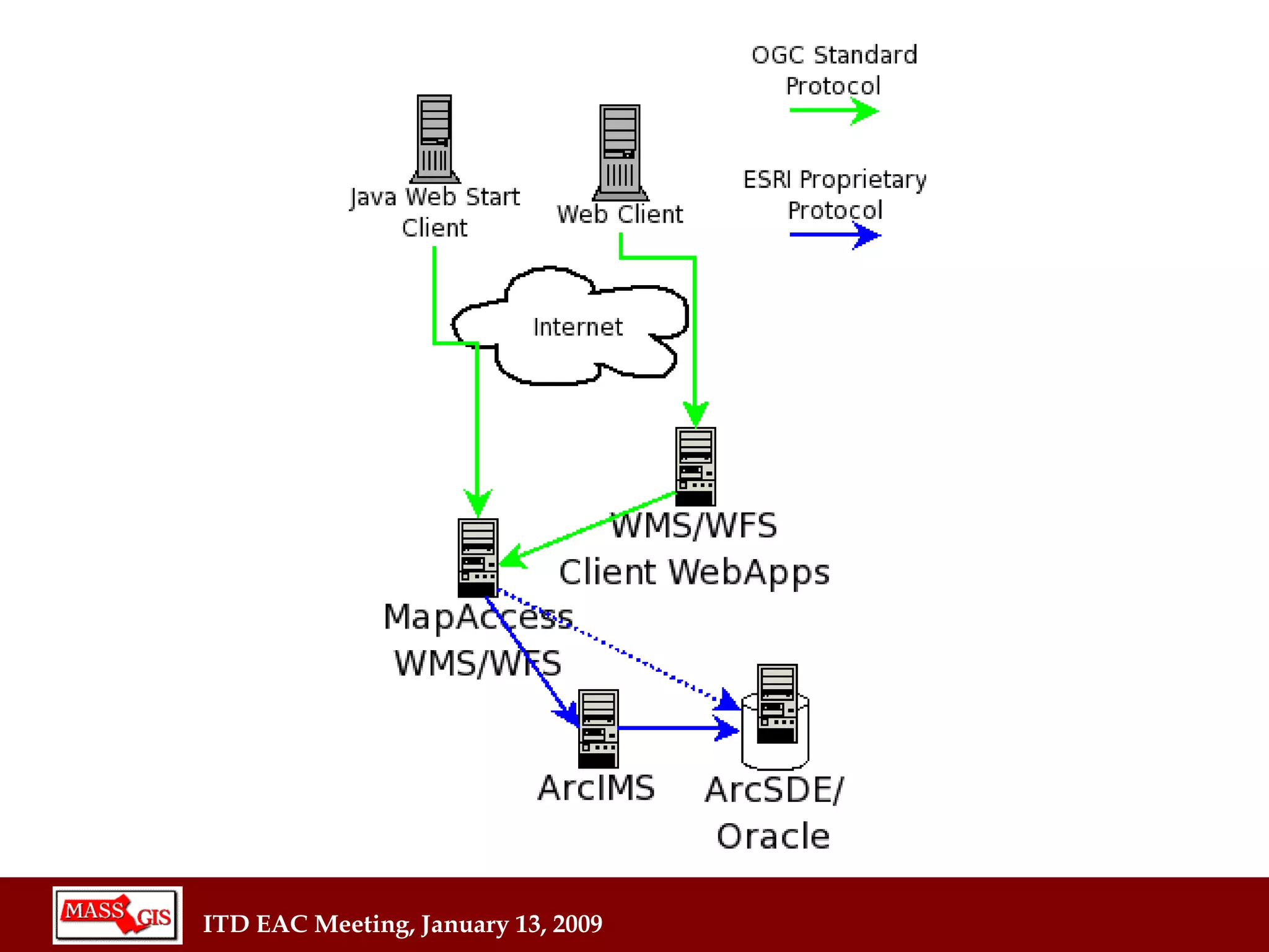
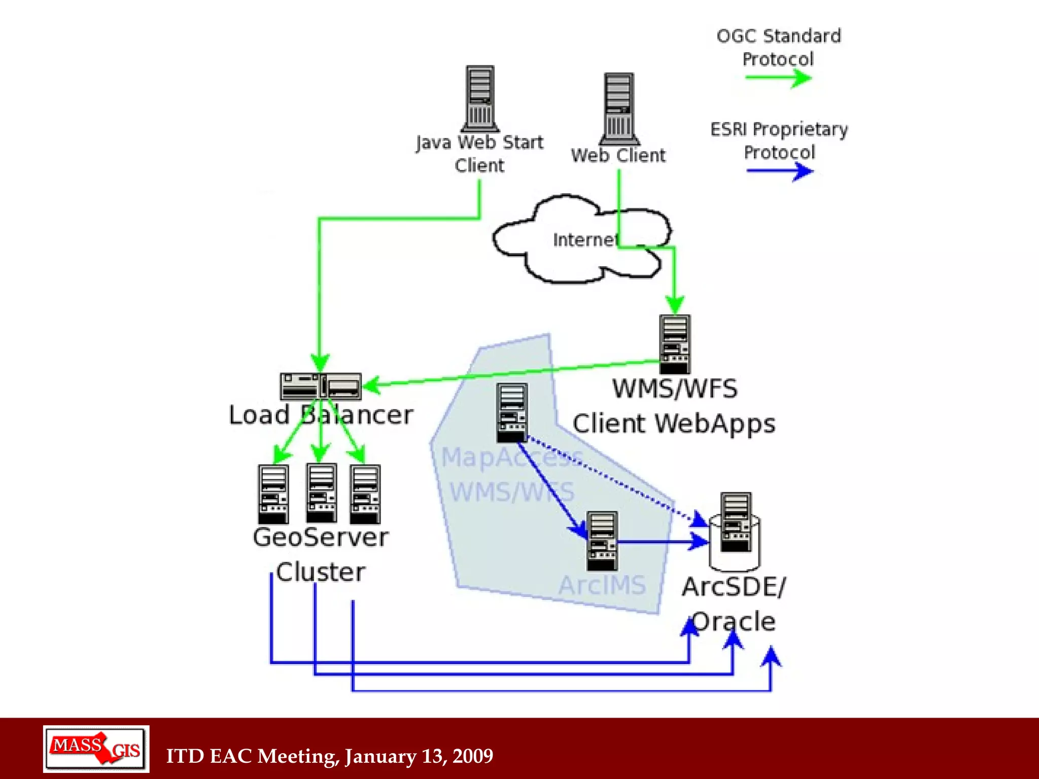
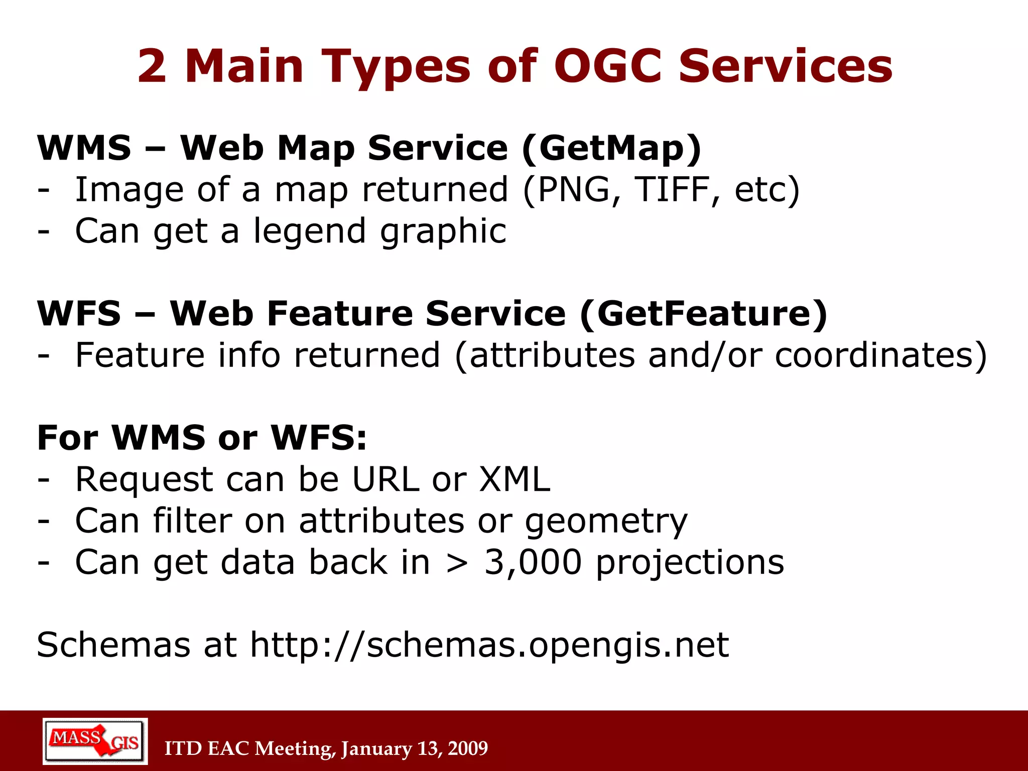
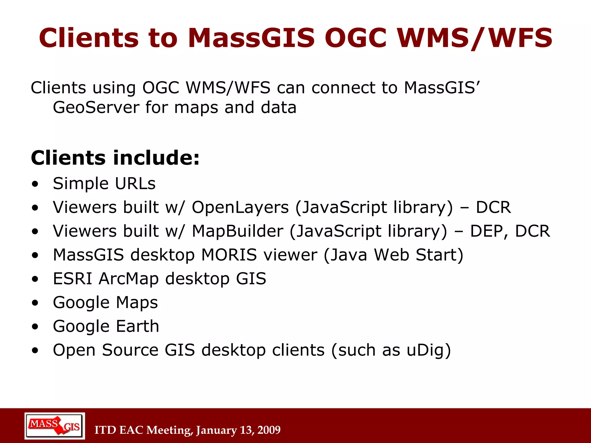
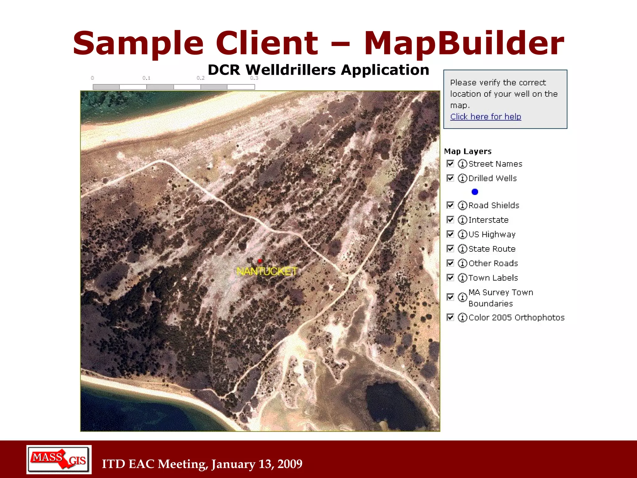
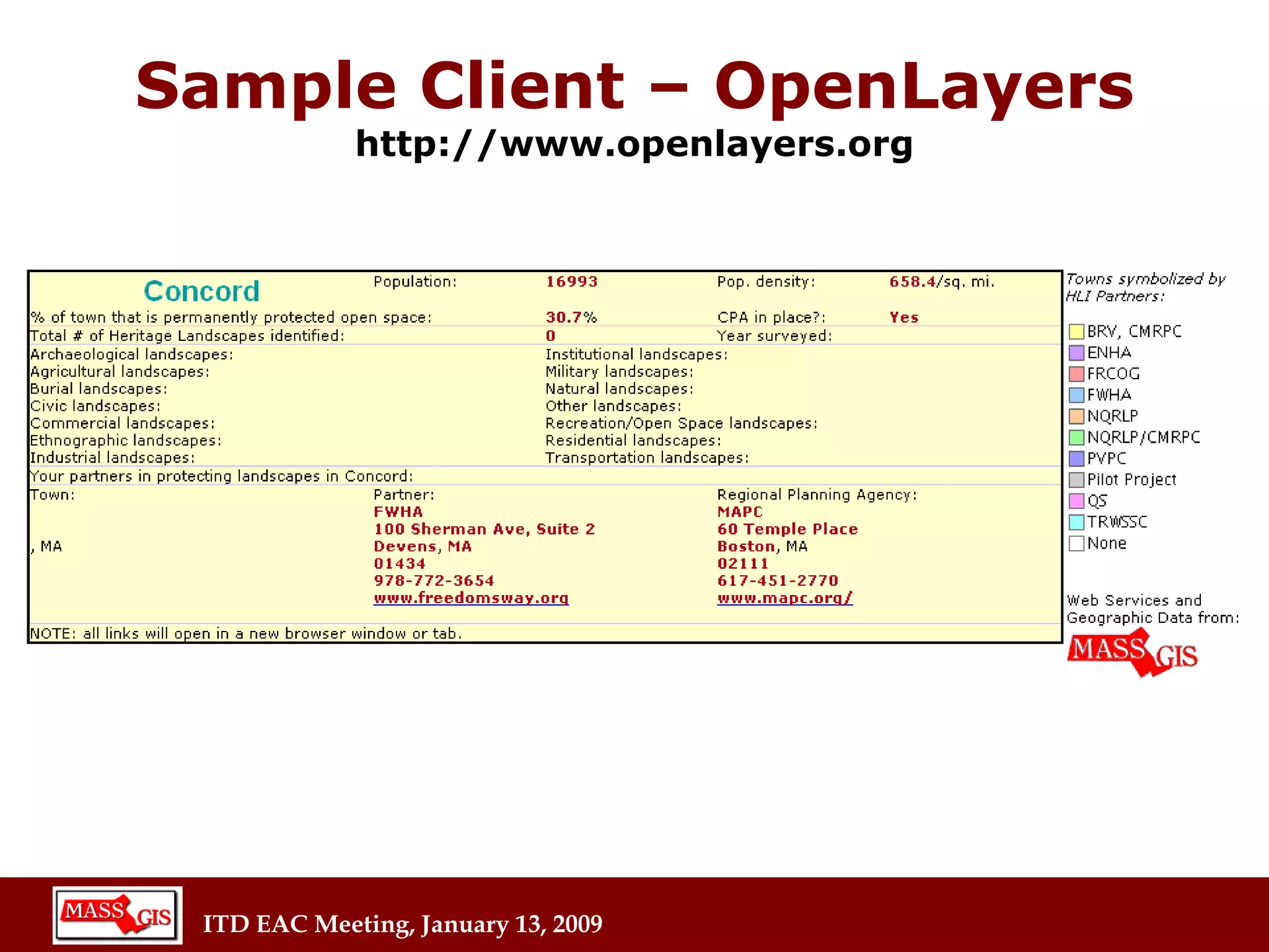
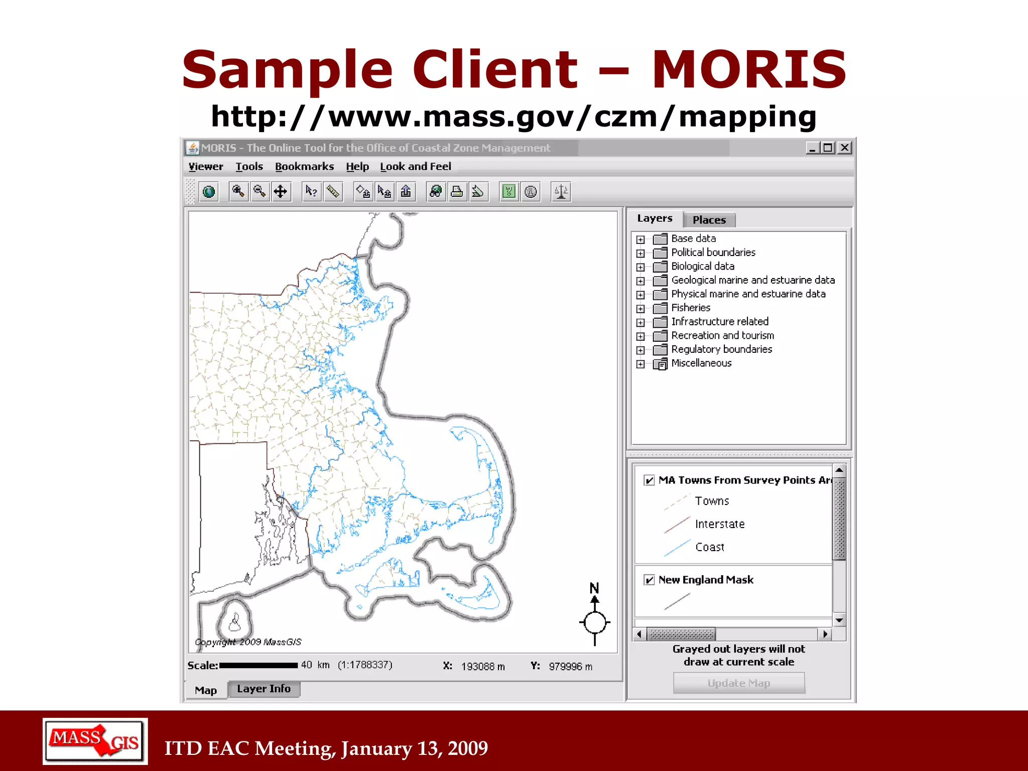
MASSGIS use of OGC Standards Aleda Freeman Office of Geographic and Environmental Information (aka MassGIS) Executive Office of Energy and Environmental Affairs (EOEEA)
Created in 1988 as the GIS office for the Executive Office of Environmental Affairs (EOEA) and its constituent agencies 1999 Legislation (MGL chap 21 sec 4B) established the “Office of Geographic and Environmental Information” in EOEA.  Its mission is very broad: “ Collect, consolidate store and provide geographic and environmental   information in order to improve stewardship of natural resources and the environment, promote economic development and guide land-use planning, risk assessment, emergency response and pollution control.” WHAT IS MASSGIS?
MassGIS Users PUBLIC SECTOR State agencies  Regional planning agencies  Cities and towns Colleges and Universities Federal agencies PRIVATE SECTOR Private non-profit organizations GIS consulting firms Engineering and surveying firms Colleges and Universities Utilities
Data Distributed by MassGIS Over 600 layers includes:  Imagery (aerial photos, topos, sea charts) Roads, Trains Parcels Schools, Town Halls, Hospitals Landuse, Open Space Lakes, Wetlands   Census data   Zoning
MassGIS Web Site  http://www.mass.gov/mgis Web site allows users to browse data layer descriptions, view data on-line, order data and standard maps, and to  download free data
History of Web Mapping Services at MassGIS 1999 Mass.gov E-gov initiative spurs development of mapping service  2002 MassGIS offers OGC standard based WMS/WFS with custom software (MapAccess) (requests translated to ArcIMS XML) 2004 Installation of GeoServer (open source, reference implementation of OGC standards)  http://www.geoserver.org
 
 
2 Main Types of OGC Services WMS – Web Map Service (GetMap) Image of a map returned (PNG, TIFF, etc) Can get a legend graphic WFS – Web Feature Service (GetFeature) Feature info returned (attributes and/or coordinates) For WMS or WFS: Request can be URL or XML Can filter on attributes or geometry Can get data back in > 3,000 projections Schemas at http://schemas.opengis.net
WMS URL Example http://giswebservices.massgis.state.ma.us/geoserver/wms?VERSION=1.1.1&REQUEST=GetMap&SERVICE=WMS&LAYERS=massgis:GISDATA.TOWNS_POLYM,massgis:GISDATA.SCHOOLS_PT&STYLES=Black_Lines,&BBOX=232325.38526025353,898705.3447384972,238934.49648710093,903749.1401484597&SRS=EPSG:26986&WIDTH=570&HEIGHT=435&FORMAT=image/png
WMS Result
WFS URL Example http://giswebservices.massgis.state.ma.us/geoserver/wfs?request=GetFeature&version=1.0.0&service=WFS&propertyname=TOWN,POP2000&typename=massgis:GISDATA.TOWNS_POLYM&CQL_FILTER=POP2000>100000
WFS Result  (partial)
Clients to MassGIS OGC WMS/WFS Clients using OGC WMS/WFS can connect to MassGIS’ GeoServer for maps and data Clients include: Simple URLs Viewers built w/ OpenLayers (JavaScript library) – DCR Viewers built w/ MapBuilder (JavaScript library) – DEP, DCR MassGIS desktop MORIS viewer (Java Web Start) ESRI ArcMap desktop GIS Google Maps Google Earth Open Source GIS desktop clients (such as uDig)
Agencies/Orgs Using MassGIS web map services Programmers doing their own work:   DEP, DCR, DOE, DFG, MassHistoric, Town of Amherst, Merrimack Valley Planning Commission, USGS   Groups getting benefit of MassGIS-created applications Community Preservation Coalition, State Police, CZM
ITD XML Gateway Some agencies (DEP, EOHHS) not allowed to contact MassGIS web services server directly – requests must go through ITD XML Gateway and be validated by schemas   Available through the gateway: WMS WFS Geocoding requests to ArcIMS (AXL, not OGC)
Sample Client – MapBuilder DCR Welldrillers Application
Sample Client – OpenLayers http://www.openlayers.org
Sample Client – MORIS http://www.mass.gov/czm/mapping
GeoServer statistics 661  layers 1,005  SLD styles 14,564  hits/day images served from cache  33%  of the time
Future Plans Current GeoServer upgrades to read all raster image types from SDE database.  Convert last MapAccess viewers and turn off MapAccess Look into increasing performance and caching
MassGIS Webservices Wiki http://lyceum.massgis.state.ma.us Working examples of requests and responses with MassGIS data

Itd Eac 1 13 09

  • 1.
    MASSGIS use ofOGC Standards Aleda Freeman Office of Geographic and Environmental Information (aka MassGIS) Executive Office of Energy and Environmental Affairs (EOEEA)
  • 2.
    Created in 1988as the GIS office for the Executive Office of Environmental Affairs (EOEA) and its constituent agencies 1999 Legislation (MGL chap 21 sec 4B) established the “Office of Geographic and Environmental Information” in EOEA. Its mission is very broad: “ Collect, consolidate store and provide geographic and environmental information in order to improve stewardship of natural resources and the environment, promote economic development and guide land-use planning, risk assessment, emergency response and pollution control.” WHAT IS MASSGIS?
  • 3.
    MassGIS Users PUBLICSECTOR State agencies Regional planning agencies Cities and towns Colleges and Universities Federal agencies PRIVATE SECTOR Private non-profit organizations GIS consulting firms Engineering and surveying firms Colleges and Universities Utilities
  • 4.
    Data Distributed byMassGIS Over 600 layers includes: Imagery (aerial photos, topos, sea charts) Roads, Trains Parcels Schools, Town Halls, Hospitals Landuse, Open Space Lakes, Wetlands Census data Zoning
  • 5.
    MassGIS Web Site http://www.mass.gov/mgis Web site allows users to browse data layer descriptions, view data on-line, order data and standard maps, and to download free data
  • 6.
    History of WebMapping Services at MassGIS 1999 Mass.gov E-gov initiative spurs development of mapping service 2002 MassGIS offers OGC standard based WMS/WFS with custom software (MapAccess) (requests translated to ArcIMS XML) 2004 Installation of GeoServer (open source, reference implementation of OGC standards) http://www.geoserver.org
  • 7.
  • 8.
  • 9.
    2 Main Typesof OGC Services WMS – Web Map Service (GetMap) Image of a map returned (PNG, TIFF, etc) Can get a legend graphic WFS – Web Feature Service (GetFeature) Feature info returned (attributes and/or coordinates) For WMS or WFS: Request can be URL or XML Can filter on attributes or geometry Can get data back in > 3,000 projections Schemas at http://schemas.opengis.net
  • 10.
    WMS URL Examplehttp://giswebservices.massgis.state.ma.us/geoserver/wms?VERSION=1.1.1&REQUEST=GetMap&SERVICE=WMS&LAYERS=massgis:GISDATA.TOWNS_POLYM,massgis:GISDATA.SCHOOLS_PT&STYLES=Black_Lines,&BBOX=232325.38526025353,898705.3447384972,238934.49648710093,903749.1401484597&SRS=EPSG:26986&WIDTH=570&HEIGHT=435&FORMAT=image/png
  • 11.
  • 12.
    WFS URL Examplehttp://giswebservices.massgis.state.ma.us/geoserver/wfs?request=GetFeature&version=1.0.0&service=WFS&propertyname=TOWN,POP2000&typename=massgis:GISDATA.TOWNS_POLYM&CQL_FILTER=POP2000>100000
  • 13.
    WFS Result (partial)
  • 14.
    Clients to MassGISOGC WMS/WFS Clients using OGC WMS/WFS can connect to MassGIS’ GeoServer for maps and data Clients include: Simple URLs Viewers built w/ OpenLayers (JavaScript library) – DCR Viewers built w/ MapBuilder (JavaScript library) – DEP, DCR MassGIS desktop MORIS viewer (Java Web Start) ESRI ArcMap desktop GIS Google Maps Google Earth Open Source GIS desktop clients (such as uDig)
  • 15.
    Agencies/Orgs Using MassGISweb map services Programmers doing their own work: DEP, DCR, DOE, DFG, MassHistoric, Town of Amherst, Merrimack Valley Planning Commission, USGS Groups getting benefit of MassGIS-created applications Community Preservation Coalition, State Police, CZM
  • 16.
    ITD XML GatewaySome agencies (DEP, EOHHS) not allowed to contact MassGIS web services server directly – requests must go through ITD XML Gateway and be validated by schemas Available through the gateway: WMS WFS Geocoding requests to ArcIMS (AXL, not OGC)
  • 17.
    Sample Client –MapBuilder DCR Welldrillers Application
  • 18.
    Sample Client –OpenLayers http://www.openlayers.org
  • 19.
    Sample Client –OpenLayers http://www.openlayers.org
  • 20.
    Sample Client –MORIS http://www.mass.gov/czm/mapping
  • 21.
    GeoServer statistics 661 layers 1,005 SLD styles 14,564 hits/day images served from cache 33% of the time
  • 22.
    Future Plans CurrentGeoServer upgrades to read all raster image types from SDE database. Convert last MapAccess viewers and turn off MapAccess Look into increasing performance and caching
  • 23.
    MassGIS Webservices Wikihttp://lyceum.massgis.state.ma.us Working examples of requests and responses with MassGIS data