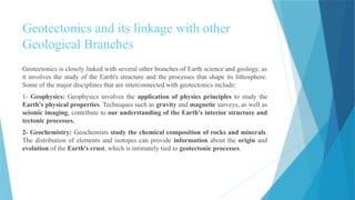
Definition
"Geotectonics" refersto the scientific study of the Earth's structure in relation to tectonic processes.
The word geotectonics is derived from two Greek words ge=earth, and tectonicon=to build. It
consequently means literally the science of the Earth's structure, but such a defnition is too wide since
it embraces, in essence, almost, the whole of geology. We need to give more precision to just what is
the true content of geotectonics.
Tectonics involves the deformation of the Earth's lithosphere (the rigid outer layer of the Earth) and
the interactions between its major components, including the crust and upper mantle.
Being a geological discipline, geotectonics is concerned with the structure, not of the whole Earth, but
mainly of its crust. In truth, however, it is necessary, in order to understand the causes determining the
observed structure of the crust and the patterns of the evolution of its structure, to investigate the
globe's deeper lying envelopes as well, but we are then already outside the scope of geotectonics
proper and are relying on the data of geophysics and geochemistry.
Definition
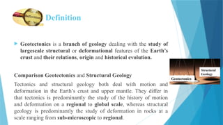
Geotectonics isa branch of geology dealing with the study of
largescale structural or deformational features of the Earth’s
crust and their relations, origin and historical evolution.
Comparison Geotectonics and Structural Geology
Tectonics and structural geology both deal with motion and
deformation in the Earth’s crust and upper mantle. They differ in
that tectonics is predominantly the study of the history of motion
and deformation on a regional to global scale, whereas structural
geology is predominantly the study of deformation in rocks at a
scale ranging from sub-microscopic to regional.
Geotectonics
Structural
Geology
4.
Key concepts andfeatures of geotectonics include:
Overview:
Understanding geotectonics is crucial for explaining the dynamic nature of the Earth's
surface and the geological processes that have shaped and continue to shape the
planet.
Researchers and geologists use a variety of tools and techniques, including
seismology, GPS measurements, and geological mapping, to study and monitor
tectonic activity.
5.
Geotectonics and itslinkage with other
Geological Branches
Geotectonics is closely linked with several other branches of Earth science and geology, as
it involves the study of the Earth's structure and the processes that shape its lithosphere.
Some of the major disciplines that are interconnected with geotectonics include:
1- Geophysics: Geophysics involves the application of physics principles to study the
Earth's physical properties. Techniques such as gravity and magnetic surveys, as well as
seismic imaging, contribute to our understanding of the Earth's interior structure and
tectonic processes.
2- Geochemistry: Geochemists study the chemical composition of rocks and minerals.
The distribution of elements and isotopes can provide information about the origin and
evolution of the Earth's crust, which is intimately tied to geotectonic processes.
6.
Geotectonics and itslinkage with other
Geological Branches
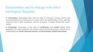
3- Volcanology: Volcanology deals with the study of volcanoes, volcanic activity, and
associated phenomena. Geotectonics is closely tied to the understanding of how and why
volcanoes form at plate boundaries, and the movement of magma beneath the Earth's
surface.
4- Seismology: Seismology is the study of earthquakes and seismic waves. Since
earthquakes are often associated with tectonic activity, seismologists play a crucial role in
understanding the Earth's internal structure and the dynamics of plate interactions.
7.
Geotectonics and itslinkage with other
Geological Branches
5- Paleontology and Stratigraphy: The study of fossils and ancient life forms is often
linked with geotectonics to understand how Earth's changing environments, driven by
tectonic processes, have influenced the evolution and distribution of life over geological
time. Stratigraphy the stratigraphic sequences is arrangement of layers that indicate
whether or not they have been subjected to overturning or a change in direction.
6. Hydrogeology: The study of groundwater and its interaction with geological formations
is influenced by geotectonics. Tectonic activity can affect the distribution of aquifers, the
movement of water, and the formation of geological structures that impact groundwater
flow.
7. Geomorphology: Geomorphologists study the landforms and surface features of the
Earth. Geotectonics influences the creation of various landforms, including mountains,
valleys, and rifts, providing the foundation for many geomorphic processes.
8.
Key concepts andfeatures of geotectonics
include:
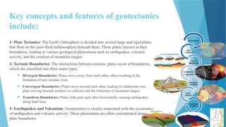
1- Plate Tectonics: The Earth's lithosphere is divided into several large and rigid plates
that float on the semi-fluid asthenosphere beneath them. These plates interact at their
boundaries, leading to various geological phenomena such as earthquakes, volcanic
activity, and the creation of mountain ranges.
2- Tectonic Boundaries: The interactions between tectonic plates occur at boundaries,
which are classified into three main types:
Divergent Boundaries: Plates move away from each other, often resulting in the
formation of new oceanic crust.
Convergent Boundaries: Plates move toward each other, leading to subduction (one
plate moving beneath another) or collision and the formation of mountain ranges.
Transform Boundaries: Plates slide past each other horizontally, causing earthquakes
along fault lines.
3- Earthquakes and Volcanism: Geotectonics is closely associated with the occurrence
of earthquakes and volcanic activity. These phenomena are often concentrated along
plate boundaries.
Geotectonics
Plate
Tectonics
Plate
Boundaries
Earthquakes
& Volcanism
Mountain
Building
Plate
Motions
Geological
Features
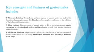
9.
Key concepts andfeatures of geotectonics
include:
4- Mountain Building: The collision and convergence of tectonic plates can lead to the
formation of mountain ranges. The Himalayas, for example, were formed by the collision
of the Indian and Eurasian plates.
5- Plate Motions: The movement of tectonic plates is driven by forces such as mantle
convection, gravitational pull, and the sinking of dense oceanic crust into the mantle at
subduction zones.
6- Geological Features: Geotectonics explains the distribution of various geological
features on Earth's surface, including ocean basins, mountain belts, rift valleys, and mid-
ocean ridges.
10.
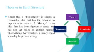
Theories in EarthStructure
Recall that a “hypothesis” is simply a
reasonable idea that has the potential to
explain observations. A “theory” is an
idea that has been rigorously tested and
has not yet failed to explain relevant
observations. Nevertheless, a theory could
someday be proven wrong.
Theory
Hypothesis
Research
Observation
11.
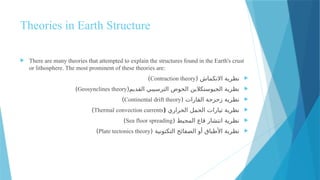
Theories in EarthStructure
There are many theories that attempted to explain the structures found in the Earth's crust
or lithosphere. The most prominent of these theories are:
نظرية
( االنكماش
Contraction theory
)
الحوض الجيوسنكالين نظرية
(القديم الترسيبي
Geosynclines theory
)
( القارات زحزحة نظرية
Continental drift theory
)
الحراري الحمل تيارات نظرية
(
Thermal convection currents
)
( المحيط قاع انتشار نظرية
Sea floor spreading
)
التكتونية الصفائح أو األطباق نظرية
(
Plate tectonics theory
)
12.
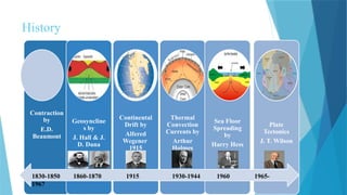
History
Contraction
by
E.D.
Beaumont
Geosyncline
s by
J. Hall& J.
D. Dana
Continental
Drift by
Alfered
Wegener
1915
Thermal
Convection
Currents by
Arthur
Holmes
Sea Floor
Spreading
by
Harry Hess
Plate
Tectonics
J. T. Wilson
1830-1850 1860-1870 1915 1930-1944 1960 1965-
1967
13.
Theories in EarthStructure
The first and second theories are no longer useful today, and they are
considered part of the history of geological scientific knowledge.
As for the third, fourth, and fifth theories, they were brought
together and a lot of new knowledge and evidence was added to
them, represented by paleomagnetism evidence, to create the sixth
theory, which is considered the most accepted theory today in
scientific circles.
14.
Theories in EarthStructure
Prior to the proposal of plate tectonics theory, most geologists had a “fixist” view of
the Earth, in which continents were fixed in position through geologic time.
In this context geologists viewed mountain building to be a consequence
predominantly of vertical motions. Pre–plate tectonics ideas to explain mountain
building included: (1) The contracting Earth hypothesis, which stated that
mountains formed when the Earth cooled, shrank, and wrinkled, much like a
baked apple removed from the oven; (2) The geosyncline hypothesis, which
stated that mountain belts formed out of the deep, elongate sedimentary basins
(known as “geosynclines”) that formed along the margins of continents.
According to this hypothesis, mountain building happened when the floor of a
geosyncline sank deep enough for sediment to melt; the resulting magma rose and in
the process deformed and metamorphosed surrounding rock. Both ideas have been
thoroughly discredited.
15.
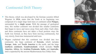
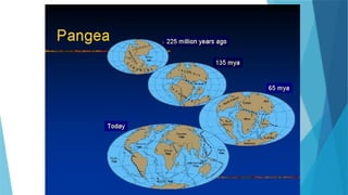
Continental Drift Theory
This theory, which was developed by the German scientist Alfred
Wegener in 1914, states that the Earth at its beginning was
composed of a single large land mass or continent called Pangea,
surrounded by a single ocean. With the passage of geological
time, this mother continent was divided into smaller continents
that began to move and move away from each other. Each other,
and these continents have not taken a fixed position since the
Earth was formed, as they have been moving continuously, but
very slowly, from time immemorial until now.
Wagner explained that this continent was divided into two
continents: the large continent of Eurasia, which includes
Europe, Asia, and North America to the north, and the large
southern continent, Gondwanaland, which includes South
America, Africa, the Arabian Peninsula, India, and Australia,
and is separated by the ancient Mediterranean Sea (Tethys Sea).
Alfred Wegener Overthinking
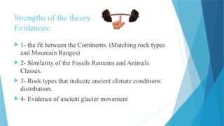
17.
Strengths of thetheory
Evidences:
1- the fit between the Continents. (Matching rock types
and Mountain Ranges)
2- Similarity of the Fossils Remains and Animals
Classes.
3- Rock types that indicate ancient climate conditions
distribution.
4- Evidence of ancient glacier movement
18.
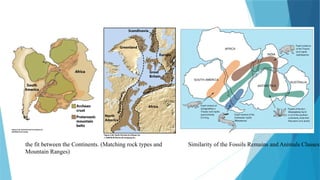
the fit betweenthe Continents. (Matching rock types and
Mountain Ranges)
Similarity of the Fossils Remains and Animals Classes
19.
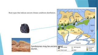
Sandstones may beancient sand
dunes.
Rock types that indicate ancient climate conditions distribution.
20.
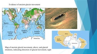
Map of ancientglacial movement, above, and glacial
striations, indicating direction of glacial movement, right
Evidence of ancient glacier movement
21.
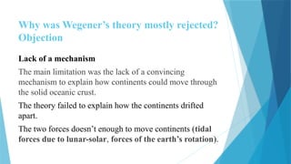
Why was Wegener’stheory mostly rejected?
Objection
Lack of a mechanism
The main limitation was the lack of a convincing
mechanism to explain how continents could move through
the solid oceanic crust.
The theory failed to explain how the continents drifted
apart.
The two forces doesn’t enough to move continents (tidal
forces due to lunar-solar, forces of the earth’s rotation).
22.
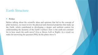
Preface
Before talkingabout the scientific ideas and opinions that led to the concept of
plate tectonics, we must review the physical and chemical properties that make up
the Earth, which contributed to developing a deeper and uniform context for
understanding the dynamic of the Earth’s surface ( how is the earth not constant/
for to how much the earth move? (Up or Down, Left or Right). As a result we
make for answering the question (Why do the plates move?)
Earth Structure
23.
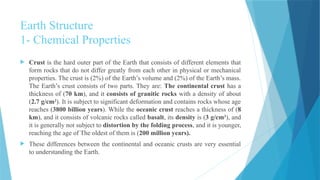
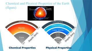
Earth Structure
1- ChemicalProperties
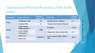
Crust is the hard outer part of the Earth that consists of different elements that
form rocks that do not differ greatly from each other in physical or mechanical
properties. The crust is (2%) of the Earth’s volume and (2%) of the Earth’s mass.
The Earth’s crust consists of two parts. They are: The continental crust has a
thickness of (70 km), and it consists of granitic rocks with a density of about
(2.7 g/cm3
). It is subject to significant deformation and contains rocks whose age
reaches (3800 billion years). While the oceanic crust reaches a thickness of (8
km), and it consists of volcanic rocks called basalt, its density is (3 g/cm3
), and
it is generally not subject to distortion by the folding process, and it is younger,
reaching the age of The oldest of them is (200 million years).
These differences between the continental and oceanic crusts are very essential
to understanding the Earth.
24.
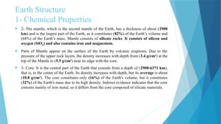
Earth Structure
1- ChemicalProperties
2- The mantle, which is the second mantle of the Earth, has a thickness of about (2900
km) and is the largest part of the Earth, as it constitutes (82%) of the Earth’s volume and
(68%) of the Earth’s mass. Mantle consists of silicate rocks. It consists of silicon and
oxygen (SiO4) and also contains iron and magnesium.
Parts of Mantle appear on the surface of the Earth by volcanic eruptions. Due to the
pressure of the upper rock layers, the density increases with depth from (3.4 g/cm3
) at the
top of the Mantle to (5.5 g/cm3
) near its edge with the core.
3- Core: It is the central part of the Earth that extends from a depth of (2900-6371 km),
that is, to the center of the Earth. Its density increases with depth, but its average is about
(10.8 g/cm3
). The core constitutes only (16%) of the Earth's volume, but it constitutes
(32%) of the Earth's mass due to its high density. Indirect evidence indicates that the core
consists mainly of iron metal, so it differs from the core composed of silicate materials.
25.
Earth Structure
2- PhysicalProperties
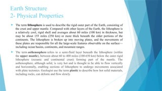
The term lithosphere is used to describe the rigid outer part of the Earth, consisting of
the crust and upper mantle. Compared with other layers of the Earth, the lithosphere is
a relatively cool, rigid shell and averages about 60 miles (100 km) in thickness, but
may be about 155 miles (250 km) or more thick beneath the older portions of the
continents. The lithosphere is broken up into moving plates, and the movements of
these plates are responsible for all the large-scale features observable on the surface—
including ocean basins, continents, and mountain ranges.
The term asthenosphere refers to a semi-fluid layer beneath the lithosphere (within
the upper mantle), between about 60 to 400 miles (100-650 km) below the outer rigid
lithosphere (oceanic and continental crust) forming part of the mantle. The
asthenosphere, although solid, is very hot and is thought to be able to flow vertically
and horizontally, enabling sections of lithosphere to undergo movements associated
with plate tectonics. Geologist use the term plastic to describe how hot solid materials,
including rocks, can deform and flow slowly.
26.
Earth Structure
2- PhysicalProperties
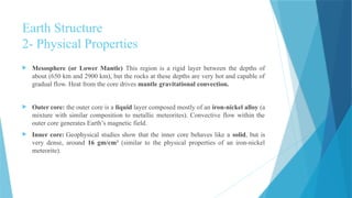
Mesosphere (or Lower Mantle) This region is a rigid layer between the depths of
about (650 km and 2900 km), but the rocks at these depths are very hot and capable of
gradual flow. Heat from the core drives mantle gravitational convection.
Outer core: the outer core is a liquid layer composed mostly of an iron-nickel alloy (a
mixture with similar composition to metallic meteorites). Convective flow within the
outer core generates Earth’s magnetic field.
Inner core: Geophysical studies show that the inner core behaves like a solid, but is
very dense, around 16 gm/cm3
(similar to the physical properties of an iron-nickel
meteorite).
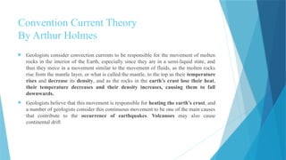
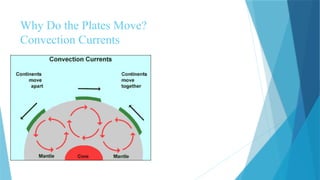
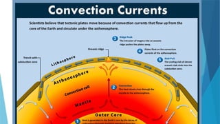
Convention Current Theory
ByArthur Holmes
Geologists consider convection currents to be responsible for the movement of molten
rocks in the interior of the Earth, especially since they are in a semi-liquid state, and
thus they move in a movement similar to the movement of fluids, as the molten rocks
rise from the mantle layer, or what is called the mantle, to the top as their temperature
rises and decrease its density, and as the rocks in the earth’s crust lose their heat,
their temperature decreases and their density increases, causing them to fall
downwards.
Geologists believe that this movement is responsible for heating the earth’s crust, and
a number of geologists consider this continuous movement to be one of the main causes
that contribute to the occurrence of earthquakes. Volcanoes may also cause
continental drift
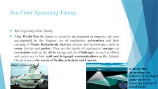
Sea Floor SpreadingTheory
The Beginning of the Theory
After World War II, thanks to scientific development or progress, this was
accompanied by the frequent use of exploratory submarines and their
carrying of Water Bathymetric Surveys devices and technologies, such as
sonar devices and probes. They are the results of exploratory voyages via
submarines such as the Alvin voyage and the Challenger, as well as efforts
and endeavors to link mail and telegraph communications in the Atlantic
Ocean between the coasts of Northern Ireland and Canada.
Alvin Submersible
A device that
determines the
distance of an object
under water by
recording echoes of
sound waves
33.
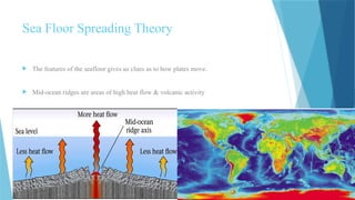
The featuresof the seafloor gives us clues as to how plates move.
Mid-ocean ridges are areas of high heat flow & volcanic activity
Sea Floor Spreading Theory
34.
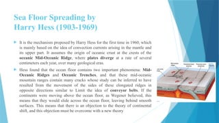
Sea Floor Spreadingby
Harry Hess (1903-1969)
It is the mechanism proposed by Harry Hess for the first time in 1960, which
is mainly based on the idea of convection currents arising in the mantle and
its upper part. It assumes the origin of oceanic crust at the crests of the
oceanic Mid-Oceanic Ridge, where plates diverge at a rate of several
centimeters each year, over many geological eras.
Hess found that the ocean floor contains two important phenomena: Mid-
Oceanic Ridges and Oceanic Trenches, and that these mid-oceanic
mountain ranges contain many cracks whose study can be inferred to have
resulted from the movement of the sides of these elongated ridges in
opposite directions similar to Limit the idea of conveyor belts. If the
continents were moving above the ocean floor, as Wegener believed, this
means that they would slide across the ocean floor, leaving behind smooth
surfaces. This means that there is an objection to the theory of continental
shift, and this objection must be overcome with a new theory
35.
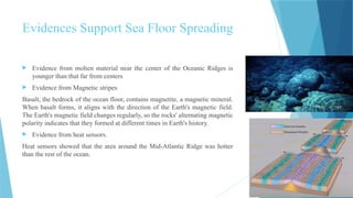
Evidences Support SeaFloor Spreading
Evidence from molten material near the center of the Oceanic Ridges is
younger than that far from centers
Evidence from Magnetic stripes
Basalt, the bedrock of the ocean floor, contains magnetite, a magnetic mineral.
When basalt forms, it aligns with the direction of the Earth's magnetic field.
The Earth's magnetic field changes regularly, so the rocks' alternating magnetic
polarity indicates that they formed at different times in Earth's history.
Evidence from heat sensors.
Heat sensors showed that the area around the Mid-Atlantic Ridge was hotter
than the rest of the ocean.
36.
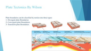
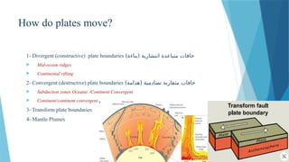
Plate Tectonics ByWilson
Plate boundaries can be classified by motion into three types:
1- Divergent plate Boundaries
2- Convergent plate Boundaries
3- Transform plate Boundaries.
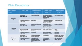
Plate Boundaries
Type ofBoundary
الحافة نوع
Types of Plates Geomorphological
Feature الشكل
الجيومورفولوجي
Geologic Events
الجيولوجية األحداث
Modern Examples
العالم في األمثلة
Divergent
تباعد
Ocean-ocean P.
محيطي-محيطي طبق
Mid-oceanic ridge Sea-floor spreading,
Shallow Earthquakes,
Rising Magma,
Volcanoes.
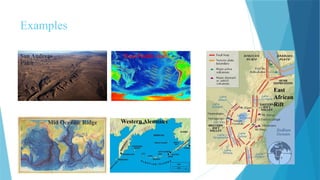
Mid-Atlantic ridge
Continent-continent P.
قاري-قاري طبق
Rift valley Continents torn apart,
Earthquakes, Rising
Magma, Volcanoes
East African rift
Convergent
تصادم
Ocean-ocean P.
محيطي-محيطي طبق
Island arcs and ocean
trenches
Subduction, deep
Earthquakes, rising
Magma, Volcanoes,
deformation of rocks
Western Aleutians
Ocean-continent P.
قاري-محيطيي طبق
Mountains and ocean
trenches
Same Events Above Andes
األنديز جبال
Continent-continent P.
قاري-قاري طبق
Mountains Deep earthquakes,
deformation of rocks
Himalayas
الهماليا جبال
Transform
انتقالي
Ocean-ocean P.
محيطي-محيطي طبق
Major offset of mid-
oceanic ridge axis
Earthquakes Offset of East Pacific
rise in South Pacific
Continent-continent P.
قاري-قاري طبق
Small deformed
mountain ranges,
deformations along
fault
Earthquakes,
deformation of
rocks
San Andreas fault
أندرياس سان فالق