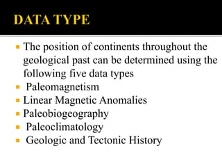
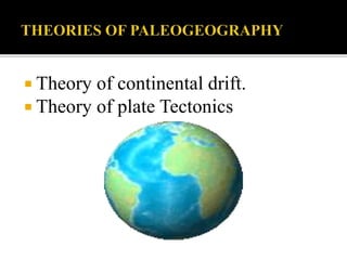
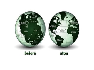
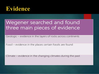
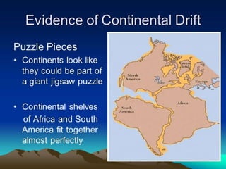
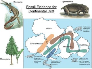
Paleogeography studies the geography of the past by mapping the positions of continents and distribution of land and seas over geological time. The positions of past continents can be determined using data like paleomagnetism, magnetic anomalies, paleobiogeography, paleoclimatology, and geological history. Alfred Wegener first proposed the theory of continental drift in 1915 to explain geological evidence that continents have moved over time, such as matching fossil and rock formations found across separated continents. Plate tectonics later expanded on this theory by proposing that Earth's lithosphere is composed of plates that move over Earth's asthenosphere, causing geological activity along plate boundaries.
Introduction to ArtificiaI Intelligence in Higher Education
Mapping Past Earth: A Guide to Paleogeography
1.
2. Paleogeography is the study of historical
geography or the geography of particular
geological past.
The study of Paleogeography has two
principle goals:
1) Mapping the Past Positions of Continents
2) Mapping the Changing Distribution of
Mountains, Lowlands, Shallow Seas and
Deep Ocean
3. The position of continents throughout the
geological past can be determined using the
following five data types
Paleomagnetism
Linear Magnetic Anomalies
Paleobiogeography
Paleoclimatology
Geologic and Tectonic History
4. How the lands and seas were distributed in past?
Did the world occupy the same position in past as we see
them on map today?
How the map of ancient world look like?
5. Theory of continental drift.
Theory of plate Tectonics
6. German Meteorologist Alfred
Wegner proposed this theory in
1915.
While working on the past climate.
He observed that there are several
places where the present climate
dose not correspond with that of
past.
1. Either the climate has changed
2. The position of the places has
been altered.
7. Continental drift was Wegener’s theory that all
continents had once been joined together in a single
landmass and have drifted apart since.
Wegener named this supercontinent Pangaea.
It explained that the continents seemed to fit together
like puzzles.
8.
9.
10.
11. Rocks of the same age and type
and displaying the same
formations are found in south-
east Brazil and South Africa.
The trends of the mountains in
the eastern USA and north-west
Europe are similar when placed
in their old positions.
Similar glacial deposits are
found in Antarctica, South
America and India, now
thousands of km apart.
12.
13. Parts of Antarctica, North America and the UK all contain coal
deposits of similar age that were formed in tropical conditions.
These areas are no longer in tropical climates which suggests that
they have drifted apart
Glacial Striations can be found that match in Brazil and West
Africa Glacial deposits are also very similar in India, South
America and in the Vaal Valley in South Africa.
These landmarks suggest that although these areas are very far
apart now they once had a very similar climate
14.
15.
16.
17. Plate tectonics is the modern version of continental drift
theory.
In 1960s, this concept was formulated by a Canadian
geophysicist J.Tozo Wilson.
The Earth's lithosphere is composed of seven or eight major
plates depending on how they are defined and many minor
plates.
Lithosphere is outer layer 100km of earth crust.
Below this semi molten or hot material layer known as
asthenosphere.
it is not the continents that are moving, but the “plates” of
lithosphere “floating” in effect on the asthenosphere
18.
19. Earthquakes, volcanicactivity, mountainbuilding
and oceanic trench formation occur along these plate
boundaries.
The relative movement of the plates typically ranges
from zero to 100 mm annually.
Tectonic plates are able to move because the Earth's
lithosphere has greater mechanical strength than the
underlying asthenosphere
20.
21. Two tectonic plates collide
What happens at convergent boundaries depends
on the kind of crust at the leading edge of each
tectonic plate.
As a result of pressure, friction, and plate material
melting in
the mantle, earthquakes and volcanoes are common
near destructive boundaries.
22.
23. The collision between the Eurasian Plate and
the Indian Plate that is forming the Himalayas.
The collision between the Australian Plate and
the Pacific Plate that formed the Southern
Alps in New Zealand
Subduction of the northern part of the Pacific
Plate and the NW North American Plate that is
forming the Aleutian Islands.
Subduction of the Nazca Plate beneath the South
American Plate to form the Andes.
24. Subduction of the Pacific Plate beneath
the Australian Plate and Tonga Plate, forming the
complex New Zealand to New
Guinea subduction/transform boundaries.
Collision of the Eurasian Plate and the African
Plate formed the Pontic Mountains in Turkey.
Mariana Trench
Subduction of the Juan de Fuca Plate beneath
the North American Plate to form the Cascade Range
25. occur where two plates slide apart from each
other.
is a linear feature that exists between two
tectonic plates that are moving away from
each other.
26. Bridge across the Alfagja rift valley in southwest Iceland
that is part of the boundary between the Eurasian and
North American continental tectonic plates.
27. Transform boundaries are places where plates slide sideways
past each other. At transform boundaries lithosphere is neither
created nor destroyed.
Manytransform boundaries are found on the sea floor, where
they connect segments of diverging mid-ocean ridges.
California's San Andreas fault is a transform boundary.