The American Institute of Architects and New England Municipal Sustainability Network convened a Design & Resilience Team with Belchertown, MA to focus on the future of the town.
This document discusses different types of street closures and projects to promote walking and biking, including open streets, car-free days, weekend walks, tactical demonstration projects, and play streets. It provides examples of these projects in Burlington, Vermont and discusses what was learned from demonstration projects on specific streets. These projects engaged the community, allowed data collection on traffic speeds and volumes, and provided evidence that protected bike lanes could reduce speeding. The document advocates putting together a long-term vision and policy framework to further promote livable streets.
DPWES 2016 Award of Excellence: Building Design and ConstructionFairfax County
This document recognizes several projects in Fairfax County, Virginia with an Award of Excellence from the Building Design and Construction Department. It honors Dominion Virginia Power, the Virginia Department of Transportation, Branch and Associates, EE Lyons Construction Company, Sorensen Gross Construction Company, and Moseley Architects for their work on the Herndon Fire Station, Huntington Levee, Stringfellow Road Park & Ride, Lorton VRE Parking Lot, and Pohick Regional Library. The award celebrates these organizations for providing quality, cost-effective buildings and infrastructure for Fairfax County.
Innovations Within Our Means, Presentation 2Trailnet
The document discusses New York City's bicycle and pedestrian programs and projects. It outlines how the NYC Department of Transportation takes both capital project and operational approaches to street design improvements. Capital projects involve full reconstruction and take years, while operational projects use surface treatments and in-house capabilities and can be completed in months. Examples of both types of projects are provided that improved safety and accessibility for bicyclists and pedestrians.
This document provides a grant report on Phase 1 of the Uptown Revitalization project in Martinsville, Virginia. The project involved enhancing pedestrian access and connections in the Uptown area through improvements like shifting Depot Street, adding a new parking area and comfort station, and installing wayfinding signs and gateways. Planning included community input. Funding came from sources like the Harvest Foundation, City of Martinsville, VDOT, and private donations. The project created a more welcoming environment for visitors and residents in Uptown Martinsville.
GWT International Conference 2022 - Powderhall: Building Opportunities for In...Alison Clyde
Robbie Crockatt, City of Edinburgh Council & Carl Baker, Collective Architecture wshare the Powderhall proposals in Edinburgh which will be one of the first in Scotland. They include an intergenerational, Passivhaus facility that combines an Early Learning and Childcare Centre for 128 children with 27 older person’s independent-living homes above. This webinar will introduce the project, setting out its origins and the approach taken by City of Edinburgh Council and by the architects, Collective Architecture in developing the final design.
This document summarizes the winners of the 2006 NSBA/AISC Prize Bridge Competition. It describes seven winning bridge projects in the categories of Major Span (Gateway Boulevard Bridge), Long Span (Appalachian Corridor H), Medium Span (Croton Dam Spillway Bridge), Short Span (Germantown Avenue Bridge), Movable Span (Col. Patrick O'Rourke Bridge), Special Purpose (Liberty Bridge), and Reconstructed (Red Cliff Arch). It provides details on the owners, designers, fabricators, and notable aspects of design and construction for each winning project.
This public event presented design concepts for the preferred trail alignment of the East Don Trail project. Attendees could view panels and presentations about the design concepts and provide feedback. The design concepts were developed by dividing the preferred alignment into segments and considering constraints like topography, trees, and infrastructure. Options were evaluated based on criteria such as environmental impacts, safety, accessibility, and costs. Feedback from the event will be used to select a preliminary preferred design concept.
Fairfax County Commercial and Industrial Property Tax for TransportationFairfax County
The Fairfax County Board of Supervisors approved an ordinance establishing the commercial and industrial property tax for transportation in September 2007. Collection of this revenue source began in 2008 (FY 2009). This revenue is just one source of many revenue sources that are needed to fund transportation improvements.
- Orange County Public Schools is rebuilding Lake Como K-8 and will hold community meetings about the project.
- During construction, Lake Como and Kaley Elementary students will attend school at Kaley Elementary.
- The new Lake Como K-8 will include classrooms, labs, athletic facilities and other educational spaces and accommodate 1,200 students.
- Community input will be gathered during the design process with the goal of opening the new school in May 2018.
This document provides a portfolio of landscape architecture projects completed by Jimmy W. Ashley, ASLA over his career from 1997-2020. It includes over 50 commercial, residential, park/recreation, and master planning projects completed while working with various firms in Raleigh, NC and through his own design studio. The portfolio showcases the wide range of project types and locations Ashley has worked on, with a focus on North Carolina.
UC Berkeley made improvements to accessibility at four sites on campus during summer 2008. The improvements included adding a drop-off area for wheelchairs at the Greek Theatre, upgrading the sidewalk to be wider and made of sustainable materials, repairing uneven and slippery surfaces on pathways, and improving a creek crossing to reduce gradients and improve lighting while respecting the natural environment. Future plans include addressing accessibility on the narrow path between Evans and Bechtel Halls and implementing wayfinding signs to identify accessible routes using universal symbols.
Burke Road Corridor Community Meeting : June 18, 2018Fairfax County
The document summarizes a community meeting held by the Fairfax County Department of Transportation regarding transportation projects along the Burke Road corridor. It discusses the results of a speed study along Burke Road, plans to study the feasibility of installing a mini-roundabout at one intersection, updates on plans for a new bicycle/pedestrian trail and the expansion of a VRE parking lot, and the status of the Burke Road Realignment Project to improve a stream crossing and alleviate flooding.
The document discusses a proposed widening project for US 82 and FM 989 in Nash and Texarkana, Texas. The goals of the project are to relieve congestion by adding lanes, improve mobility for local and through traffic, enhance safety at intersections and for turning movements, and provide for pedestrian and bicycle use. For US 82, the proposal is to widen it to a four-lane divided urban section with sidewalks. For FM 989, the proposal is to widen it to a six-lane divided urban section with sidewalks and a possible multi-use path. Stakeholders that would be involved include adjacent property owners, cities, county, MPO, schools, utilities, and the public. The project
Kimberly Johnson has over 15 years of experience in television, film, and commercial production. She has worked as a set decorator, props assistant, producer, director, editor, and talent coordinator on various TV shows, commercials, music videos, and independent films. Johnson has received several awards for her documentary films at the Sidewalk Film Festival and Red Bull Writers Block contest. She is proficient in editing software such as Adobe Premier, Final Cut Pro, and Avid. Johnson holds a Bachelor's degree in Communications Studies from the University of Alabama at Birmingham.
Georgetown Pike at Dolley Madison Blvd Pedestrian Improvements July 2020 july...Fairfax County
This document provides details about a pedestrian improvement project at the intersection of Georgetown Pike and Dolley Madison Boulevard in Fairfax County, Virginia. The project involved installing sidewalks, shared use trails, and drainage improvements. A contractor completed the work, which included grading areas for the new paths and sidewalks, installing concrete and asphalt, and replacing an existing stormwater pipe. Photos show the improvements which enhanced pedestrian safety and accessibility at the intersection.
This document summarizes the results of a community planning process in Damariscotta, Maine called the Heart and Soul Planning Project. The project identified community values through public engagement activities. These values centered around working and living locally, access to culture and nature, an involved community, and a sense of community. The document outlines specific action items under each value to guide land use planning and policy changes. Next steps discussed include additional community workshops, drafting code amendments including form-based codes, and a town-wide vote on any proposed code changes.
Colter Cothren is seeking a position in the construction industry and has over 15 years of experience as a surveyor and supervisor for pipeline construction projects throughout the US. He has strong technical skills including experience with GPS, data collection, and CAD software. Cothren has a proven track record of safely supervising crews and ensuring quality control on survey documentation.
Citizens Information Meeting: Sleepy Hollow Road Walkway - April 23, 2018Fairfax County
The document summarizes a citizens information meeting about planned improvements to a walkway along Sleepy Hollow Road in Fairfax County, Virginia. It discusses the purpose of adding 4,400 feet of new walkway for pedestrian connectivity and ADA compliance. The project has undergone design changes since the first community meeting, including shifting the sidewalk location between two streets, utilizing the parking lane for part of the sidewalk, and modifying pedestrian crossings and refuge islands. It outlines the project schedule and addresses from the county department of transportation for any additional questions.
Clairemont CPG Ad Hoc Subcommittee MeetingCirculateSD
On Tuesday, May 10, 2016, the project team presented on the study area's existing condition to the Clairemont Community Planning Group Ad Hoc Subcommittee.
The city of Potosi is seeking to improve pedestrian connectivity with a new sidewalk plan. The plan proposes constructing a sidewalk along Jefferson Street from Mill Street to the elementary school, requiring a crosswalk over Park Drive, a busy two lane road. It provides three route options for the sidewalk. The city also wants a long-term master plan to make the city more walkable with interconnected sidewalks. The proposal includes budgets, timelines, and maintenance costs for the different design options.
Leathers & Associates Penny Park Design Day Presentation cityofevanston
This document provides information about L&A, a company that has been designing and building playgrounds for 40 years using recycled plastics. It discusses their materials and design process, which involves gathering community input, creating schematic designs, and getting feedback. Their process is managed by L&A project managers who guide committees through planning and construction.
The Sustainable Design Assessment Team program provides broad assessments to help communities plan for sustainability. It considers environmental stewardship, social equity, and economic development. The SDAT process involves a multi-disciplinary team of outsiders that gather community participation. Their assessment helps frame future policies and solutions regarding the three pillars of sustainability.
This document summarizes planning projects done by high school students in Simsbury, Connecticut and Boston, Massachusetts.
In Simsbury, AP Economics students were tasked with reimagining redevelopment plans for a vacant site. They proposed a variety of uses including parks, retail, offices, housing, and more. In Boston, students helped plan improvements to Mt. Vernon Street by advocating for safer pedestrian and bicycle infrastructure. They shared perspectives as users and helped educate the public. The resulting plan included protected bike lanes, landscaping, and improved crosswalks to create a more livable street for all. Engaging students provided valuable insights and helped advance successful community-oriented projects.
The document discusses plans to improve parks, trails, and recreational facilities in the Willow Fork community. It proposes creating a network of trails connecting parks and schools. Research is cited showing that access to green space and trails increases home values and promotes active lifestyles. Specific projects are outlined, such as expanding existing parks and creating a new community central green space. Funding would come from bonds issued over 7 years without raising taxes.
The document outlines the process and findings from a planning team's visit to Covington, Kentucky. It discusses engaging the community through interviews and tours to understand assets like being resource rich and having trust within institutions. The team identified opportunity sites for housing and a niche in sustainable neighborhoods. Scenarios were created for Randolph Park, including a community school. Next steps discussed further engaging the community to build upon ideas and partnering to take action.
FPC Greensboro, FInal Master Plan Presentation, December 13, 2010fpcadmin
This document provides a facility master plan for First Presbyterian Church of Greensboro. It includes an assessment of the existing campus facilities and programming needs. The master plan proposes a phased renovation and construction plan to address accessibility, connectivity, and space utilization issues. Key elements include renovating existing buildings, removing one building, constructing a new entry building with atrium and classrooms, and expanding parking. The plan aims to create a more cohesive and accessible campus that supports the church's ministries and community outreach goals.
1) The document discusses the Fraser Centre, a proposed mixed-use development project in State College, PA near Penn State University.
2) The project includes 50 units of housing, retail space, classrooms that can also be used as cinema space, and a residents-only parking garage.
3) A key challenge was developing a financial model that worked for the mixed-use concept. Penn State's agreement to sublease the cinema space for classroom use helped address this challenge.
The document summarizes an AIA SDAT process to develop recommendations for strengthening the Court Avenue corridor in Jeffersonville, IN. A team of 6 professionals toured the area, held stakeholder meetings, and brainstormed designs over 3 days. They heard feedback that the corridor feels neglected, unsafe for all users, and empty after 5pm. The team analyzed growth opportunities based on demographics, economic factors, and urban design. Their presentation outlined designing a healthy corridor with best practices for mobility, including pedestrian safety treatments, bike infrastructure, stormwater management, and phased improvements. Immediate next steps included developing an action plan and applying low-cost safety measures.
"Strengthening the City's Civic Spine: The Future of Court Avenue," is the final presentation of the American Institute of Architects Sustainable Design Assessment Team to the community of Jeffersonville, Indiana. A national team of volunteer professionals worked with the community through a 3-day public process to produce a community-driven strategy for the area.
On May 1st the Parks Foundation and Minneapolis Park Board hosted a community open house, unveiling the evolved design concept for Water Works park on the Mississippi riverfront in downtown Minneapolis. At the open house, community members were invited to offer input on the new design concept. This presentation was given by the design team during the open house, highlighting the history of Water Works, project timeline, and cultural resources.
The presentation was given by:
Bruce Chamberlain – Minneapolis Parks Foundation
Kate Lamers - MPRB Water Works Project Manager
Anne Ketz - The 106 Group
Tom Whitlock – Damon Farber Landscape Architects
Joan Soranno – HGA
Max Musicant – The Musicant Group
Learn more about Water Works at https://goo.gl/x03GKe
This document summarizes discussions from a Complete Streets summit regarding rural transportation infrastructure. Key points include: there was general support for Complete Streets where appropriate but not on all rural roads; priorities included connecting gaps in sidewalk networks and linking low-income areas to services; bike routes should stay off-road where possible; and initial costs were a major concern along with maintenance responsibilities. A street typology plan was developed through public input to guide context-sensitive design. Recommendations included traffic calming on lake streets, improving trail connections, and prioritizing "destination streets". Specific projects were discussed, such as improving crosswalks along busy routes, building sidewalks to connect destinations, and enhancing safety at trail crossings.
In early 2019 Habitat for Humanity in Paterson, NJ contacted the APA-NJ chapter to talk about their need for a team of volunteer planners. They wanted to create a concept for a green space along the Passaic River in the Northside Neighborhood of Paterson, NJ. They wanted two types of green space; a walkway along the river, called Riverwalk, and a sports fields in an area along the river dominated by abandoned and marginal industrial and residential properties. The Northside Neighborhood is across the Passaic River from Downtown Paterson.
The document provides information on Robin Massingill's landscape architecture education and experience. It includes a resume with details on her bachelor's degree from the University of Arkansas, study abroad program, phone number, email, and website. It also lists previous positions as a resident assistant, teaching assistant, landscape architect intern, and camp counselor. Coursework, leadership roles, and honors are mentioned. At the end are three project summaries: the Cave Springs Ecology Sanctuary, Queensway Elevated Community, and Vestal Urban Farm.
The document summarizes feedback from a public meeting about the West Park Branch of the Cleveland Public Library. Key recommendations from the community engagement process include expanding parking, addressing maintenance issues, making the downstairs meeting rooms accessible by adding an elevator, overhauling the front entrance and ramp, creating a separate space for teens, and exploring additional types of seating and study areas. The community also recommended using the front lawn area for better signage, landscaping, and lighting along the main road, as well as pursuing collaborations with the neighboring YMCA.
The document discusses elements that contribute to a successful town center, including a cohesive design that creates a unique character, active main streets, beautiful public spaces, good circulation, and practices of sustainability. It then provides an analysis of Montgomery Township in central New Jersey, describing its history, population growth, median incomes, housing values, and potential for solar energy due to climate and solar exposure.
Montgomery Township, NJ Town Planning Presentation FinalCKEARNEY
The document discusses plans for developing a town center in Montgomery Township, New Jersey. It outlines goals of establishing a sense of place and community through creating a cohesive mixed-use development with public spaces, active streets, and preservation of natural areas. Sustainability is also a priority, with plans for LEED-certified buildings, green roofs, permeable paving, and stormwater management.
The document discusses the benefits of smarter growth and development patterns that concentrate new growth in existing communities rather than allowing sprawl. If current trends continue, 800,000 new acres of land would be developed by 2030, much in rural areas. However, better land use, community design and transportation can help address issues like energy use and climate change. Examples are given of areas like Tysons Corner that were retrofitted into more walkable, mixed-use communities with transportation options beyond cars. The vision is to apply these principles more broadly to benefit both the environment and quality of life.
2035 Comprehensive Plan - May Public Workshopssumnerplanning
The document provides an update on Sumner County's 2035 Comprehensive Plan. It summarizes public meetings that were held in May 2010 to review the plan's vision, objectives, and general framework map. The meetings also briefly reviewed the county's transportation system and gathered public input on transportation issues. The document outlines the plan's process and components addressed so far, including natural resources, land use, and transportation. It provides maps of the proposed future land use and discusses transportation trends, components, and safety issues to be addressed in the plan.
This proposal seeks funding to improve pedestrian safety and connectivity along Winston Drive in San Francisco. Winston Drive connects multiple southwest neighborhoods to public transit and recreational areas like Lake Merced and the zoo. The project would install new sidewalks, widen existing sidewalks, improve crosswalks, and add traffic calming measures to benefit pedestrians, cyclists, and transit riders along the corridor. Specifically, it would correct deficiencies, open a closed campus crosswalk, lift a section of road, and add landscaping to improve safety and accessibility for the thousands of pedestrians expected to use the corridor daily.
An AIA Sustainable Design Assessment Team produced a suburban retrofit strategy for the Dale Blvd corridor in Dale City, VA, following a 3-day community process.
Similar to Belchertown, MA Design & Resilience Team (20)
The final presentation of the AIA national design team from its community process in Savannah, Georgia. The team focused on the Canal District and neighborhoods of West Savannah by working in a community driven process led by the Ivory Bay Development Corporation, neighborhood organizations, and elected leaders.
The document discusses democratic urbanism, a method of city building that emphasizes public participation and democratic decision making processes. It finds that poor public engagement is limiting cities' ability to address challenges, and that building capacity for participation is important. Democratic urbanism provides an adaptable model for developing solutions that have broad public support. It advocates for improving processes to meaningfully involve the public and develop collective solutions at the local level.
This document discusses the importance of public participation and democratic urbanism for community health and city planning. It provides examples of how inclusive community engagement processes have led to positive placemaking outcomes, such as transforming derelict areas into active public spaces with gardens and cultural assets. Truly collaborative approaches that involve citizens in decision making from the beginning help address issues of apathy and opposition, build social capital, and create places that reflect community values. In contrast, top-down "smart city" projects and an "orgy of public process" can undermine urban democracy and civic empowerment. When cities leverage culture and citizen ideas, remarkable impacts on people and communities are possible.
Presentation to the Regional/Urban Design Committee Symposium, "Mind the Gap: The Future of Urban Design Education," at the American Institute of Architects, Jan 2019.
Keynote address given to University of South Florida on the occasion of World Health Day, addressing global urbanization and its impact on global health as well as participatory urban design and its contribution to healthy cities.
The document summarizes a report from the Design & Resiliency Team (DART) on creating a resilient future for Southern Nevada. It discusses:
- The members of DART and their backgrounds in planning, sustainability, and resiliency.
- The concept of "hedging bets" and creating redundancy in Southern Nevada's resiliency plan to protect against various risks like drought, heat waves, and storms.
- DART's analysis of Southern Nevada's vulnerabilities and recent weather events that exposed vulnerabilities like drought and extreme heat.
- Frameworks and principles for building resiliency, including involving communities, addressing social and economic equity, using scientific data, and aligning efforts across levels of
Vinalhaven, Maine hosted a Design & Resilience Team (DART) in October 2017 to produce a strategy on adaptation to sea-level rise, downtown revitalization, and livability.
Panel organized for the RECAST conference in Santa Fe, marking the 20th anniversary of the public process that created the Santa Fe Railyard Redevelopment. Panelists included: Joel Mills, Cheryl Morgan, Erin Simmons, and Thea Crum. The panel explored issues facing cities today and multiple democratic methodologies (participatory budgeting, democratic urbanism) for city building.
The American Institute of Architects' Sustainable Design Assessment Team (SDAT) presentation to the Helper, Utah community following a 3 day public process to build revitalization strategies.
The American Institute of Architects and Urban Sustainability Directors Network partnered with the community of Dubuque, Iowa to produce a strategy on climate and resilience in the context of equity and health.
Presentation to the American Planning Association's National Planning Conference, New York City, May 2017. Presenters Wayne Feiden, Joel Mills, Eva Hull.
The final presentation of the Reimagine Dublin One process. From March 9-13, 2017 an American and Irish team of professionals worked with the Dublin One community to develop a series of regeneration strategies for the neighborhood.
The document discusses efforts to redevelop waterfront areas in Washington, DC through large-scale projects like the 30-year, $10 billion Anacostia Waterfront Initiative that involves 19 partners. It highlights some specific projects, including The Wharf mixed-use development, estimated at $2 billion and encompassing 3.2 million square feet on 25 acres with additional water space and amenities. The document also notes the history of the Anacostia River being used as an effective latrine and how the redevelopments aim to correct past mistakes and balance residential, business and ecological concerns.
Final presentation of the American Institute of Architects' Sustainable Design Assessment Team (SDAT) to the community of Oakland, Maryland on strategies for downtown revitalization. November 2016.
Workshop presentation to the International Association for Public Participation (IAP2) annual conference in Montreal framing a discussion about how to spread good P2 practice.
This document summarizes an AIA workshop on community resilience and urban challenges. It discusses trends like globalization, inequality, climate change and governance crises. It emphasizes the importance of participatory design and facilitative leadership skills to address these issues. The document advocates training a new generation of "citizen architects" through curriculum that empowers communities and instills values of democratic and collaborative urban planning. It provides examples of past AIA projects that transformed cities through community-driven design processes.
This document discusses the potential for grassroots civic engagement and public participation (P2) to address issues facing communities. It notes declining trust in government and challenges like climate change, housing, and inequality. However, P2 processes that meaningfully involve the public in decision-making can help communities invest in their future without relying on national government. Examples show how P2 has led to revitalization efforts, land use reforms, and design improvements. The document argues that citizen architects and coalitions can use P2 and advocacy campaigns to drive positive change from the local level up.
Technoblade The Legacy of a Minecraft Legend.Techno Merch
Technoblade, born Alex on June 1, 1999, was a legendary Minecraft YouTuber known for his sharp wit and exceptional PvP skills. Starting his channel in 2013, he gained nearly 11 million subscribers. His private battle with metastatic sarcoma ended in June 2022, but his enduring legacy continues to inspire millions.
Connect Conference 2022: Passive House - Economic and Environmental Solution...TE Studio
Passive House: The Economic and Environmental Solution for Sustainable Real Estate. Lecture by Tim Eian of TE Studio Passive House Design in November 2022 in Minneapolis.
- The Built Environment
- Let's imagine the perfect building
- The Passive House standard
- Why Passive House targets
- Clean Energy Plans?!
- How does Passive House compare and fit in?
- The business case for Passive House real estate
- Tools to quantify the value of Passive House
- What can I do?
- Resources
PDF SubmissionDigital Marketing Institute in NoidaPoojaSaini954651
https://www.safalta.com/online-digital-marketing/advance-digital-marketing-training-in-noidaTop Digital Marketing Institute in Noida: Boost Your Career Fast
[3:29 am, 30/05/2024] +91 83818 43552: Safalta Digital Marketing Institute in Noida also provides advanced classes for individuals seeking to develop their expertise and skills in this field. These classes, led by industry experts with vast experience, focus on specific aspects of digital marketing such as advanced SEO strategies, sophisticated content creation techniques, and data-driven analytics.
Storytelling For The Web: Integrate Storytelling in your Design ProcessChiara Aliotta
In this slides I explain how I have used storytelling techniques to elevate websites and brands and create memorable user experiences. You can discover practical tips as I showcase the elements of good storytelling and its applied to some examples of diverse brands/projects..
Decormart Studio is widely recognized as one of the best interior designers in Bangalore, known for their exceptional design expertise and ability to create stunning, functional spaces. With a strong focus on client preferences and timely project delivery, Decormart Studio has built a solid reputation for their innovative and personalized approach to interior design.
ARENA - Young adults in the workplace (Knight Moves).pdfKnight Moves
Presentations of Bavo Raeymaekers (Project lead youth unemployment at the City of Antwerp), Suzan Martens (Service designer at Knight Moves) and Adriaan De Keersmaeker (Community manager at Talk to C)
during the 'Arena • Young adults in the workplace' conference hosted by Knight Moves.
Fonts play a crucial role in both User Interface (UI) and User Experience (UX) design. They affect readability, accessibility, aesthetics, and overall user perception.
Practical eLearning Makeovers for EveryoneBianca Woods
Welcome to Practical eLearning Makeovers for Everyone. In this presentation, we’ll take a look at a bunch of easy-to-use visual design tips and tricks. And we’ll do this by using them to spruce up some eLearning screens that are in dire need of a new look.
Visual Style and Aesthetics: Basics of Visual Design
Visual Design for Enterprise Applications
Range of Visual Styles.
Mobile Interfaces:
Challenges and Opportunities of Mobile Design
Approach to Mobile Design
Patterns
Explore the essential graphic design tools and software that can elevate your creative projects. Discover industry favorites and innovative solutions for stunning design results.
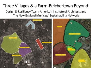
1. Three Villages & a Farm-Belchertown Beyond
Design & Resiliency Team: American Institute of Architects and
The New England Municipal Sustainability Network
2. Three Villages & a Farm- Belchertown Beyond
Design & Resiliency Team
Wayne Feiden, FAICP
Director of Planning and Sustainability, Northampton, MA
Leah Bamberger
Director of Sustainability, Providence
Michael Cavanaugh, AIA LEED AP
Vice president and sustainability leader, CannonDesign, Boston
Jon Ford, PE
Professional engineer, Horsley Witten Group, Providence
Ellen Morosoff Pemrick
Principal, E.M. Pemrick and Company
Erin Simmons (project staff)
Senior Director of Design Assistance, AIA, Washington DC
Dylan Zingg (report layout)
Garrison Gamble (graphics coordinator)
3. Community Voices
“Don’t want us become just
another bedroom at eat at
McDonalds.”
“Belchertown has lots of
amenities, but they are
spread out.”
“[We] grew without a lot of
forethought.”
“We need a hub.”
“…Development IF its good
development.”
“we tend to plan piecemeal”
6. Implementation
• Foley Field
• Jessica’s Boundless Playground
• Route 202 design advancing
• State School planned demolition
• Christopher Heights assisted living
10. Cultural Connections
• Stone House Museum
• Fair
• “Carriage Capital”
• Town Common
• State School
• Local arts and crafts
• Performing Arts Center
• Studio space
• Galleries
• Athletic fields &
playgrounds
• Trails
• Bike Path
• Indoor facilities
• NESFI
• Farmer’s Market
• Community Kitchen
• Farm-to-table / retail
• Agricultural Education
Center
Food Recreation
HistoryArts
12. Food
Lampson Brook
Farm
• Provide food
for schools,
restaurants,
assisted living
facilities
• Anaerobic
Digestion /
Compost
State School
• Ag. Education
Center
• Light Food
Processing
• Community
Kitchen
• Food incubator
space
• Brewery/
Distillery
Town Center
• NESFI Store
• Farm-to-table
restaurants
• B&Bs
14. Recreation
Lampson
Brook Farm
• Nature trails
• Birding
State School
• Active
recreation
• Indoor
recreation
facility
Town Center
• Passive
recreation
• Bike path
19. History
Lampson Brook
Farm
• Environmental
history
• Inception with
the State
School
State School
• Honor
historical
significance
• Preserve
buildings and
tell the site’s
story
Town Center
• Restore
historic value
of the Town
Common and
surrounding
buildings
• Draw in
visitors
21. A Story Worth Telling
• Part of Belchertown’s
history
• Raises awareness for the
developmentally-
disabled
• Demonstrates the
progress made in
understanding and
supporting these
populations
• Personal connections
23. Art
Lampson
Brook Farm
• Drawing
• Painting
• Photography
State School
• Artist
live/work and
studio space
• Shared studio
spaces
Town Center
• Galleries
• Music
• Outdoor
movies
35. TOWN CENTER Streetscape Principles
• Buildings close to the street
• Critical mass, density, diversity of uses
• Windows & doors
• On-street parking
• Narrow, slow-speed streets
• Complete streets = balanced for all users
• Green infrastructure
• Street trees
51. The Farm
Significant Features to preserve:
- Siloes – historical significance/re-use
- Main Barn – Educational hub
- Open Space / Agriculture
- View to Holyoke range and to State School Property
56. CORRIDOR CONNECTIVITY Vehicular Mobility
New State School
Connection
Adds a link to the
network to improve
mobility
Courthouse Bus
Extension
Turn-around at Rt. 21
Future State School stop
Under
evaluation
Under
evaluation
Future
57. Farm to
State Street
New path
connectivity
Nature trails
Lampson Brook
Improve sense
of arrival
ADA loop
around lake
Common to Bridge
5’ concrete sidewalks
both sides
Add street trees
Intersection
Improvements
Consolidate intersection
to eliminate ped.
crossing & add
crosswalk
Alternative path
Explore improvements
to existing path cut-
through to bypass
bridge
Intersection
Improvements
Tighten intersections &
add special crosswalks
Pedestrian Connectivity
Fill gaps to extend to
Courthouse, Playground
& Schools
Bridge
Widen sidewalk
State Street
New buffered shared
use path on north side
Courthouse
New buffered
shared use path
on south side
CORRIDOR CONNECTIVITY Ped/Bike Mobility
Under
evaluation
Under
evaluation
Future
Main St.
On-street lanes
Bike parking
59. State Street at Stadler/Front
• No traffic signal
• Faded Crosswalks
• Undefined corners
• Sidewalks close to
roadway
60. State Street at Stadler/Front
• Four-way Traffic
signal
• New Crosswalks
• Defined, protected
corners
• Sidewalks inboard
from roadway
• Some buildings
closer to street
61. GET STARTED Public Space
• Start building momentum – ALTA is coming
• Restriping for traffic calming & on-street parking
• Temporary parks coordinated with programming & public art
62. GET STARTED Green
• Neighborhood tree plantings
• Green infrastructure demonstration project
• Parking lot retrofits
• Municipal building retrofits
• Green roof bus stops
• Green improvements + gateways/wayfinding
• Pavement to parks
71. Can include:
Agriculture & food systems
Small businesses
Responsible use of resources
Entrepreneurship - "home-grown" businesses
Socially
Responsible
Economically
Viable
Environmentally
Sound
A BALANCED APPROACH TO ECONOMIC DEVELOPMENT
72. Market Analysis Overview
Existing retail primarily serves
local residents
No “regional draw”
Competing shopping venues and
higher traffic counts in nearby
communities
Recent/anticipated population
growth not enough to support
large retail centers
Retail leakage to nearby
communities, workplaces, online
73. The Town Common
Historic and cultural
center
Economic objectives
Retain/support existing
businesses
Address barriers
Provide/enhance cultural
opportunities to restore
vitality
Pursue compatible
business development
and recruitment (long-
term)
74. The Town Common
Cultural opportunities
Arts activities & events at Clapp Memorial Library
Live music at McCarthy’s Pub
Stone House tours & events
Performing Arts Center at United Church of Christ
Town fair, farmers market
Outdoor movie nights
Potential amphitheater on the Common?
75. The Town Common
Compatible business opportunities
B&B or small-scale lodging
Arts space for kids
Old-fashioned general store
Specialty foods and farm products
Restaurants and cafes
Professional services
76. The Town Common
Co-working space
Workspace for individuals
who work from home
“A place to work, network,
learn, and socialize”
Desks or tables and chairs
Meeting space
Copiers
Wi-Fi access
77. Four Corners Area
Highway-oriented retail &
service businesses
Local/convenience goods and
services - e.g., grocery store,
pharmacy
Economic objectives
Retain/support existing businesses
Fill vacancies in existing space
Avoid shifting retail activity
78. State School Area
Master Plan calls for mix of uses… assisted
living, independent living to be developed first
Economic objectives
Continue to meet local needs
Enhance marketability of State School property
Pursue compatible business development and
recruitment (long-term)
79. “Give people a reason to come”
Recreation as a potential
economic driver
Develop/attract a multi-use
recreational facility to serve
residents and attract visitors
Enhance/promote trail networks
Consider drop-in location or rec
center for teens
State School Area
80. Public Sector
Botetourt Sports Complex,
Botetourt County, VA
Recreational “Destinations” Examples
Private Sector
Fore Kicks, Norfolk, MA
81. Considerations
Needs and interests of local users
Programming & facilities should not compete with
existing resources
Potential partnerships - location near schools a
plus
Market analysis
Sound business plan
Financial feasibility
Recreational “Destinations”
84. Regulatory Actions
• Review subdivision and zoning regulations to better
support pedestrians and cyclists
– See resource: “Commentary on Updating Subdivision
Regulations in Massachusetts” – The Trustees of Reservation
• Review zoning regulations to protect agricultural land
– Currently allow residential single-unit dwellings in AG-A zone—
the town’s prime farmland.
• Petition state to transfer Lampson Brook Farm land to the
town or other mission-oriented organization
• Participate in MassDOT’s Complete Streets program to get
access to funding
• Continue application of Commercial Design Guidelines
• Include trails in open space plans to make them eligible for
funding
85. Subdivision Regulations: Sidewalks
• “Bituminous Cement concrete sidewalks shall
be constructed on one both sides of the
roadway when contiguous with other town
sidewalks or if required by the Planning Board.
The Planning Board may require sidewalks to
encourage pedestrian activity and provide
more security for pedestrians.”
• “Be a minimum of four five feet in width.”
86. Subdivision Regulations: Sidewalks
• Sidewalks should extend across driveways
– E.G. “Where driveway aprons cross cement concrete
sidewalks, aprons shall also be constructed with cement
concrete to create continuity with sidewalk areas.”
• Create mix use, commercial, and industrial subdivisions
sidewalk standards
Residential Yield Street Mixed Use Commercial
and Industrial
Sidewalk (cement concrete
only, including where it
crosses driveway)
5’ wide on one side. Both
sides required if traffic
counts > X per day
6’ wide on both sides
Crosswalks Raised to elevation of
sidewalk
Raised to elevation of
sidewalk
87. Subdivision Regulations: Street Trees
“Where, in the opinion of the Planning Board,
the existing trees to remain are not adequate,
provisions for two street trees per lot may be
required for each lot. Species, size and planting
procedures shall be approved, in writing, by the
Planning Board. Street trees shall be planted at
an average interval of 50 30 feet on both sides
of the street separating individual trees or at an
interval required by the Planning Board.”
89. Complete Streets
• Mass DOT Complete Streets Funding Program
– To be eligible for up to $50,000 in technical
assistance and up to $400,000 in construction
funding, a municipality must meet three primary
requirements:
• Attendance of a municipal employee at a Complete
Streets training
• Passage of a Complete Streets Policy
• Development of a Complete Streets Prioritization Plan
– Upon completion of these requirements,
municipality is eligible for construction funds
90. First 100 days?
•Install State St/Rte 202 wayfinding signs
•Advance Rte 202 design concepts w/Alta Design
•Design State St tactical urbanism w/Alta Design
•Adopt MassDOT complete streets policy
•Adopt walk-friendly subdivision regulations
•Draft walk-friendly zoning site plan standards
•Draft NESFI zoning district for only farming uses
•Request UMass Landscape Arch Town Commons Studio
•Second look at four state school buildings
•File legislation-transfer ownership Lampson Brook Farm
91. Thanks-residents and staff
Douglas Albertson; Stephen Williams; LeeAnn
Connolly; Judy Metcalf; Sarah Bankert; Caitlen
Marquis; Pat Berry; Bill Terry; Kurt Steven; Judy Gillan
Thanks-WMAIA & UMass graphics support
Garrison Gable (Graphics Coordinator); Dylan Zingg
(Report Layout); Gabrielle Bernier; Randy Crandon;
Michael Szczerepa; Michael Choudhary; Melody
Tapia, Daniel Fontaine, Amibca Chadha, Shuo LI,
Madison Burke
92. Three Villages & a Farm-Belchertown Beyond
• Vision
• Cultural Story
• Connectivity
Presentation and Final Report
www.DesignResiliency.org
www.aia.org/liv_sdat