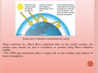
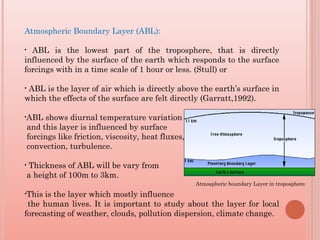
- The atmospheric boundary layer (ABL) is the lowest part of the troposphere directly influenced by the Earth's surface. It exhibits diurnal temperature variations and responds rapidly to surface forcings.
- GPS radio occultation (RO) technique uses GPS signals passed through the atmosphere to determine properties like temperature, pressure, and water vapor in the ABL. Data from the COSMIC satellite constellation has provided global observations of the boundary layer.
- GPS RO is a useful remote sensing technique for studying characteristics of the ABL like refractivity and temperature profiles, with advantages of all-weather capability and global coverage.
Meteorology is a discipline concerned with observational earth sciences and theoretical physics. It has the task of providing an accurate knowledge of the state of the atmosphere. Before the advent of weather satellites the weathermen had been severely handicapped by having only a very limited knowledge of the state of the atmosphere at any given time. Meteorological satellites have to a large extent has enabled to overcome this deficiency.
The earth is the only known planet, on which life exists. The present condition and properties of earth’s atmosphere are one of the main reasons for earth to support life. The atmosphere is the blanket of gases or vapours that surrounds the earth, and held together by the force of gravity.
The density and distribution of climatological stations to be established in a land network within a given area depend on the meteorological elements to be observed, the topography and land use in the area, and the requirements for information about the specific climatic elements concerned. This module highlights all these aspects.
Everywhere you look this is significant innovation occurring in the real estate space. In this session, Mike DelPrete looks at new models that are gaining traction and disrupting real estate agents, and how property portals around the world are adapting to these changes. Finally, Mike dusts off the crystal ball and looks at the future of the online real estate industry.
Upon the completion of this chapter, you will be able to:
Distinguish between weather and climate,
Explain the place to place distribution of temperature and rainfall in Ethiopia,
explain the time to time patterns of temperature and rainfall in Ethiopia,
Analyze climate and its implications on biophysical and socioeconomic aspects,
identify the causes, consequences and response mechanisms of climate change.
5.1 The concept of weather and climate
Both weather and climate are concepts about atmospheric conditions. The basic difference on them is duration and areal coverage.
Weather is atmospheric condition observed in a very specific area with a short term fluctuation, while
Climate is a prolonged(30-35years) atmospheric condition observed in a relatively wider geographic area.
Weather condition likely changed hour to hour, in a daily base or weakly but climate is relatively permanent.
Elements of Weather and Climate
Elements(components) of weather and climate are the following variables
Atmospheric temperature (how cold or hot is the atmosphere)
Precipitation (any kind of moisture falling from the atmosphere to the ground, mostly rainfall)
Air pressure (the weight exerted by the air)
Humidity (the level or proportion of water vapor within the atmosphere)
Sunshine (the duration and intensity of solar heat as well as light)
Wind (horizontal motion of air)
The Ozone Layer: Formation and DepletionKamran Ansari
This presentation explains the Earth's atmosphere and its composition and variation of temperature and pressure in different layers of the atmosphere. It contains atmospheric circulation in troposphere and stratosphere. It explains the process of ozone formation and how its stability affects by the other chemical components which lead to the ozone depletion and ozone hole. It also contains the cosmic ray theory of ozone hole.
The Earth’s climate is dynamic and characterised by trends, aberrations and quasi-periodic oscillations varying over a broad range of time-scales [1], which are governed by external (extraterrestrial systems) and/or internal(ocean, atmosphere and land system). Trends are largely controlled by plate tectonics, and thus to change gradually on million year time scale. Aberrations occur when the certain thresholds are passed and are manifested in the geological record as the unusual rapid (less than a few thousands of years) or extreme change in climate. The quasi-periodic oscillations are mostly astronomically paced; they are driven by astronomical perturbations that affect the earth’s orbit around the sun and the orientation of earth’s rotation axis with respect to its orbital plane. These perturbations are described by the three main astronomical cycles: eccentricity, precession and obliquity, which together determine the spatial and seasonal pattern of insolation received by the earth [2], eventually resulting in climatic oscillations of ten to hundreds of thousands of year [3].Sun being the main source of energy for the earth system controls the climate of it. Variation in solar activity and cosmic ray intensity has direct influence over climatic features such as cloudiness, temperature and rainfall [4]. Volcanic eruptions also force all elements of the climatic systems up to a varying degree but producing long term climatic signals in the ocean. The cumulative volcanic cooling effect at present offsets about one third of anthropogenic warming [5].Other than these causes paleoclimatologists also relates the past climate changes with movement of solar system[6], interplanetary dusts and influence of asteroids[7].However the recent variability in climate what earth is experiencing is unlikely due to any of the individual above factors rather it is due to the compound effect of complex interactions of all the natural as well as anthropogenic forcings.
References:
1. J. C. Zachos, M. Pagani, L. Sloan, E. Thomas, K. Billups, Science 292 (2001) 686-693.
2. G. Kukla, Nature (London) 253, 600 (1975).
3. J. D. Hays, J. Imbrie, N. J. Shackleton, Science 194 (1876) 1121-1132.
4. N. Marsh, H. Swensmark, Space Sci. Rev. 94 (2000) 215-230.
5. T. L. Delworth, V. Ramaswamy, G. L. Stenchikov, Geophys. Res. Lett. 32 (2005) L24709.
6. K. Fuhrer, E. W. Wolf, S. J. Johnsen, J. Geophys. Res. 104(D24) (1999) 31043-31052
7. P. Hut, W. Alvarez, W. P. Elder, T. Hansen, E. G. Kauffman, G. Keller, E. M. Shoemaker & P. R. Weissman, Nature Vol. 329, 10 September, 1987
Operation “Blue Star” is the only event in the history of Independent India where the state went into war with its own people. Even after about 40 years it is not clear if it was culmination of states anger over people of the region, a political game of power or start of dictatorial chapter in the democratic setup.
The people of Punjab felt alienated from main stream due to denial of their just demands during a long democratic struggle since independence. As it happen all over the word, it led to militant struggle with great loss of lives of military, police and civilian personnel. Killing of Indira Gandhi and massacre of innocent Sikhs in Delhi and other India cities was also associated with this movement.
How to Split Bills in the Odoo 17 POS ModuleCeline George
Bills have a main role in point of sale procedure. It will help to track sales, handling payments and giving receipts to customers. Bill splitting also has an important role in POS. For example, If some friends come together for dinner and if they want to divide the bill then it is possible by POS bill splitting. This slide will show how to split bills in odoo 17 POS.
We all have good and bad thoughts from time to time and situation to situation. We are bombarded daily with spiraling thoughts(both negative and positive) creating all-consuming feel , making us difficult to manage with associated suffering. Good thoughts are like our Mob Signal (Positive thought) amidst noise(negative thought) in the atmosphere. Negative thoughts like noise outweigh positive thoughts. These thoughts often create unwanted confusion, trouble, stress and frustration in our mind as well as chaos in our physical world. Negative thoughts are also known as “distorted thinking”.
This is a presentation by Dada Robert in a Your Skill Boost masterclass organised by the Excellence Foundation for South Sudan (EFSS) on Saturday, the 25th and Sunday, the 26th of May 2024.
He discussed the concept of quality improvement, emphasizing its applicability to various aspects of life, including personal, project, and program improvements. He defined quality as doing the right thing at the right time in the right way to achieve the best possible results and discussed the concept of the "gap" between what we know and what we do, and how this gap represents the areas we need to improve. He explained the scientific approach to quality improvement, which involves systematic performance analysis, testing and learning, and implementing change ideas. He also highlighted the importance of client focus and a team approach to quality improvement.
Students, digital devices and success - Andreas Schleicher - 27 May 2024..pptxEduSkills OECD
Andreas Schleicher presents at the OECD webinar ‘Digital devices in schools: detrimental distraction or secret to success?’ on 27 May 2024. The presentation was based on findings from PISA 2022 results and the webinar helped launch the PISA in Focus ‘Managing screen time: How to protect and equip students against distraction’ https://www.oecd-ilibrary.org/education/managing-screen-time_7c225af4-en and the OECD Education Policy Perspective ‘Students, digital devices and success’ can be found here - https://oe.cd/il/5yV
Instructions for Submissions thorugh G- Classroom.pptxJheel Barad
This presentation provides a briefing on how to upload submissions and documents in Google Classroom. It was prepared as part of an orientation for new Sainik School in-service teacher trainees. As a training officer, my goal is to ensure that you are comfortable and proficient with this essential tool for managing assignments and fostering student engagement.
Unit 8 - Information and Communication Technology (Paper I).pdfThiyagu K
This slides describes the basic concepts of ICT, basics of Email, Emerging Technology and Digital Initiatives in Education. This presentations aligns with the UGC Paper I syllabus.
How to Create Map Views in the Odoo 17 ERPCeline George
The map views are useful for providing a geographical representation of data. They allow users to visualize and analyze the data in a more intuitive manner.
Model Attribute Check Company Auto PropertyCeline George
In Odoo, the multi-company feature allows you to manage multiple companies within a single Odoo database instance. Each company can have its own configurations while still sharing common resources such as products, customers, and suppliers.
2. Outline of talk:
• Earth’s Atmosphere
• Atmospheric Boundary Layer (ABL) Definition
and importance
• Diurnal variations of ABL
• Mechanisms or processes taking place in ABL
• GPS RO technique
• GPS RO technique usage for ABL
3. Atmosphere:
• Atmosphere is a layer of gases, aerosols and hydrometeors that covers the
earth and protects the earth from ultraviolet radiation of sun and the
temperature extremes are changing from day to night.
• Sun is the main source of the atmosphere. Gases, aerosols and
hydrometeors in the atmosphere absorbs some amount of solar radiation
which leads to the variation of thermal structure in atmosphere with
altitude.
• Atmosphere consists of 4 layers depending on its thermal structure.
1.Troposphere
2.Stratosphere
3.Mesosphere
4.Thermosphere
4. •Solar radiation (ie., Short Wave radiation) falls on the earth’s surface, the
surface gets heated up and it reradiates or reemits Long Wave radiation
(LWR).
• The LWR and convection plays a major role in the weather and climate of
lower atmosphere.
Long wave radiation reemission by earth
5. Atmospheric Boundary Layer (ABL):
• ABL is the lowest part of the troposphere, that is directly
influenced by the surface of the earth which responds to the surface
forcings with in a time scale of 1 hour or less. (Stull) or
• ABL is the layer of air which is directly above the earth’s surface in
which the effects of the surface are felt directly (Garratt,1992).
•ABL shows diurnal temperature variation
and this layer is influenced by surface
forcings like friction, viscosity, heat fluxes,
convection, turbulence.
• Thickness of ABL will be vary from
a height of 100m to 3km.
•This is the layer which mostly influence
the human lives. It is important to study about the layer for local
forecasting of weather, clouds, pollution dispersion, climate change.
Atmospheric boundary Layer in troposphere
6. Diurnal variations of ABL:
Fig 1: Diurnal variation of ABL showing different layers (1)
7. •Earth usually responds to changes of the radiative forcing which leads
to the diurnal variation of ABL.
•The solar heating will creates the thermal plumes, this plumes rises
and expands adiabatically up to reaching an equilibrium state.
•This rising of plumes and sinking of cool air will transport the
moisture, heat and aerosols.
•ABL has again divided into sub layers:
•Stable layer
•Surface layer
•Mixed layer and residual layer.
•ABL is driven by various mechanisms like radiative forcings, friction,
turbulence. The physical quantities like wind flow velocity, temperature
and moisture rapid fluctuations are strongly seen in the ABL
8. •The surface of the atmosphere encounters obstacles like trees, buildings
etc., which will reduce the velocity of the flow of air molecules which will
be stable called as stable layer.
•The layer in which the wind, temperature and humidity rapidly varying
with altitude due to turbulence will starts is known as ‘Surface layer’. It
will be up to few tens of meters.
•Due to the thermal or convective eddies rising from the surface layer and
associated turbulence, causes the well mixing of fluid (air) which is known
as ‘Mixed layer’.
•The flow of fluid near the surface will be changed by the interaction
earth’s topography in the form of Viscosity ie., molecular viscosity, which
transfers momentum due to random motions of molecules. The molecular
interaction/motion will creates disturbance, this triggered disturbance will
form the ‘Turbulence’.
•During day time Wind shear turbulence and convective generated
turbulence will exists. During Night time only wind shear will be
available.
9. •This random motions causes turbulence in ABL. This turbulent flow is
generated due to wind and temperature variations of eddies. Turbulent flow
fluid is responsible for mixing in the ABL.
•Aerosol concentration will be more in the atmospheric boundary layer then it
gradually decreases.
• Potential temperature showing in the figure is maximum at ground level
where the heat is delivered and then shows a uniformity across the Convective
boundary layer which indicates the higher mixing.
Fig: Typical vertical profile of Potential temperature and Aerosol
concentration on day time Boundary layer (Garratt, 1992)
10. Importance of ABL and different instruments for ABL studies:
• Study of ABL is important because of these processes affect our lives directly
or indirectly (influencing the weather).
• Most of the weather processes will occur in ABL only like turbulence,
Friction, Winds, Vertical transport of momentum and energy.
• Different instruments will be used for the ABL studies, which are insitu
measurements and Remote measurements.
• Insitu measurement instruments like cup anemometer, Hygrometer,
resistance thermometer etc., these sensors will be mounted on a tower to
collect the data. Remotely measuring instruments like SODAR, Lower
Atmospheric Wind profiler, LIDAR etc., Satellite based measurements such
GPS RO technique is widely used to study the boundary layer characteristics.
11. GPS RO Technique:
• GPS satellites are primarily using for positioning and navigation. The GPS
satellites emits radio signals at L1(1.57 GHz) and L2(1.22 GHz).
• A Low Earth Orbit satellite contains an RO instrument and observes GPS
satellites in the limb. As the density varies with height in atmosphere which
will refract or bent the GPS signal. This bending signal magnitude and angle
depends on the refractivity gradient of the atmosphere.
GPS Radio occultation. (photo : PlanetiQ)
• A constellation of satellites COSMIC using GPS RO technique provides radio
refractivity information with global coverage. Radio Occultation technique
based on Satellite, gives a global studies on ABL.
12. • On 15 April 2006, the joint Taiwan - U.S. Constellation Observing System
for Meteorology, Ionosphere, and Climate (COSMIC)/Formosa Satellite
Mission 3 (COSMIC/FORMOSAT-3, hereafter COSMIC) mission, a
constellation of six microsatellites, was launched into a 512-km orbit.
•GPS RO technique needs no active calibration, it is weather independent
and global coverage is possible.
Features of GPS Radio Occultation: (COSMIC website)
• Assured long-term stability
• All-weather operation
• Global 3-D coverage: 40 km to the surface
• Vertical resolution: ~100 m in the lower troposphere
• Independent height, pressure, and temperature data
• A compact, low-power, low-cost sensor
• High accuracy: Averaged profiles to < 0.1 K
13. • Studies using GPS RO technique has been carried out by Kursinski et
al(1996), ware etal (1996), Rocken etal., (1997), Ratnam etal(2010)
previously.
•From GPS Ro gives the information of Phase delay which provides,
Temperature
Pressure
Water vapor
Ionic density
Refractivity
Bending angle
Atmospheric refractive index where is the light velocity
in a vacuum and v is the light velocity in the atmosphere
Refractivity
P=Pressure, T= Temperature, ew= water vapor content
)1(106
−= nN
vcn /= c
2
5
1073.36.77
T
e
T
P
N w
×+=
14. •GPS RO provides a valuable global view of the height-resolved refractivity
or moisture structure of ABL. The information about the refractivity from
which one can derive the atmospheric properties in the Boundary layer.
• Atmospheric Boundary Layer studies using satellite based measurements
and ground based measurements like Lidar, radiosondes etc.,
comparatively provides an accurate information about the properties of the
ABL.
• GPS RO and Lidar techniques are used to know the information of the
most reliable characterization of the ABL has to be carry out.
15. References:
• R.B.Stull (1999), An introduction to boundary layer meteorology, Kluwer Aca
demic Publishers, London.
•Garratt, J. R. (1994), The Atmospheric Boundary Layer, 315 pp., Cambridge
Univ. Press, New York.
• Air Pollution Training Institute website (APTI)
www.shodor.org/os411/courses/411c/module06/unit01/page01.html.
• Lidar.ssec.wisc.edu/papers/akp_thes/node6.html
• S. Sokolovskiy, Monitoring the atmospheric boundary layer by GPS radio
occultation signals recorded in the open-loop mode, Geophysical research letters,
Vol:33, L12813, 2006.
•COSMIC website http://www.cosmic.ucar.edu/ro.html
•Kursinski et al. 1996: Initial results of RO observations of Earth’s atmosphere using the
GPS. Science, 271, 1107-1110.
• Ware et al. 1996: GPS sounding of the atmosphere from low earth orbit: preliminary results.
Bull. Amer. Meteor. Soc., 77, 19-40.
• Rocken et al. 1997: Analysis and validation of GPS/MET data in the neutral atmosphere. J.
Geophys.Res., 102, 29849-29866.