SlideShare a Scribd company logo
International Journal of Engineering Science Invention
ISSN (Online): 2319 – 6734, ISSN (Print): 2319 – 6726
www.ijesi.org ||Volume 4 Issue 11|| November 2015 || PP.54-59
www.ijesi.org 54 | Page
Application of GIS in Evaluationof Coastal River Bathymetry,
A Case Study of OpoboChannel, Rivers State, Nigeria
Ezeugwu M. U1
, Idhoko K.E2
, Nnamah, P.O3
and Ofuenyi J. O4
Department of Surveying and Geo-informatics, Faculty of Environmental Sciences, Nnamdi
AzikiweUnversity, Awka. Nigeria.
ABSTRACT :Opobo Channel is the lower section of Imo River-II, adjoining the Estuary into the Atlantic.
The channel connects two important towns, Opobo in Rivers State and IkotAbasiin AkwaIbom of Nigeria. The
unexplored socio-economic potential of these towns has been hindered by poor navigability of the only marine
channel from the sea. OpoboChannel was only and lastly dredged in 1996 when Aluminium Smelting
Company of Nigeria (ALSCON) became operational. A marine vessel delivering petroleum products to
Synergy Tank Farm in IkotAbasiran aground in 2014 at the Estuary due to reduced channel bathymetry and
estuarine accretion.A bathymetry survey was conducted in February 2015 to determine the existing water
depth profile of the 14km (7.64nautical miles) channel from the Estuary to IkotAbasi, hence its
navigability.Computer assisted data analysis using Geographical Information System (GIS) was employed
toassess and evaluate the acquired bathymetric data. Based on planned deployment of 8m maximum draft
vessel, 45% of the channel, was discovered to be deeper than 8m while the rest is less. This shows that for
safeyear-round navigation, 55% of the channelrequires dredging. The data was further used to create a
dredge limit of 12m water depth and the total volume of material to be dredged was computed. It’s
recommended that periodic bathymetric survey be planned to continuously monitor rate of siltation along the
Channel, including the Estuary and the Fair-way sections. It’s expected that with further bathymetric data
acquisition and analysis, it will be possible to predict when subsequent maintenance dredging shall be
conducted to keep the channel open and free for safe all-year-round navigation.
Keywords:-bathymetric survey, morphology, accretion, siltation, sediment budget, estuaries, hydrography,
water depth, GIS.
I. INTRODUCTION
Opobo Channel is the main marine link from two major coastal towns,IkotAbasiand Opoboto the Atlantic.
Opobo is land locked with no motorable land access, while IkotAbasi is not. The geographical location of
IkotAbasi has a great untapped socio-economic potential,which is hindered by poor navigability of the marine
channel from the sea. Due to the existing dual carriage express road leading to the nearest capital cities of Port
Harcourt and Uyo, if fully developed, IkotAbasi could serve as the next major sea-port (inland) in the south-
south region of Nigeria.
The main objective of the hydrographic survey is to assess the existing water depth and its suitability for safe
navigationbetween IkotAbasi and the Opobo Channel estuary.According to (Payoyo, 1994), coastal and marine
areas are ever increasing in value to the welfare of nations and her citizens. These areas provide natural, social
and economic functions that contribute toincreased quality of life. In addition to the aforementioned, the coastal
environment is instrumental in determining climate thatbeneficially affects all life on Earth. Some social and
economicfunctions include tourism, commercial and recreational fishing, oil and gasdevelopment, and
construction (Eckert, 1979; Prescott, 1985; Gomes, 1998).It is clear therefore that coastal and marine areas are
of vital importance to human life and the nation as a whole, which IkotAbasi could be explored to full
benefit.The facts that approximately 71% of the planet‟s surface is covered with water and that these are as rich
and productive as the land in terms of food and transport, increase the importance of hydrographic
measurements (Erkaya and Hoşbaş, 1998; Ozgen and Algul, 1977).
The navigability of Opobo channel is the key to unlock the potential of IkotAbasi leading to development of a
port that will not only add to thenation‟srevenue but also improve the life of impoverished indigenes of
IkotAbasi and environ. The backbone to this is the morphological characteristics of the channel, i.e., the channel
width and water depth. The channel width ranges from 1m to 1.7km, which is of no concern, irrespective of
morphological changes over time. The main concern is water depth which is a function of the sediment
Application of GIS in Evaluation of Coastal…
www.ijesi.org 55 | Page
dynamics and the resulting hydrographic profile of the channel bed. In today‟s dynamic world of advancing
technology, computer assisted data analysis currently plays an important role in creating a graphical
representation of scenes for easy understanding and appreciation by its audience. This serves as a vital key in
decision-making for coastal protection, development and management, especially of national and natural
resources of great help to man-kind.
Geographic Information System (GIS) is a computer-based information management system used to digitally
represent and analyze geo-spatial features. It is used to input, store, manipulate, analyze and output spatially
referenced data (Burrough and McDonnell, 1998). A GIS can be distinguished from database management
systems or from visualization packages through its specialized capability for spatial analysis. The use of GIS for
coastal zone management has expanded rapidly during the past decade and references are numerous (Durand,
1994; Populus, 2000; Wright and Bartlett, 2000). GISiscommonly used in efficient and effective data
management for hydrographic data (Millett and Evans, 2009). This computer assisted data analysis tool, was
considered as best fit and therefore, used to manipulate the acquired bathymetric data to create a visual
representation of channel water depth profile in different forms. Such as:-
1. Existing water depth and bottom profile, between IkotAbasiand the estuary.
2. Considering maximum vessel draft of 8m, section with sufficient depth was shown, including section
with insufficient water depth that will require dredging.
3. A threshold water depth limit of 12m was assumed for uniform dredging, and then the volume of
material to be dredged was computation.
II. STUDY AREA
Opobo Channel is the lower section Imo River-II, located south-south region of Nigeria. It‟s tidal and connects
both IkotAbasi and Opobocoastal towns to the Atlantic. Numerous creek and creek-lets connected the channel,
includingJaja Creek, Fine Face Creek and Strong Face Creeks. Imo River-11 is the administrative boundary
between AkwaIbomand Rivers Statesof Nigeria. It‟s located between Latitude 040
33‟ 55.31‟‟ and 040
28‟
30.04‟‟Northof Equatorand Longitude 070
31‟ 31.63‟‟ and 070
35‟ 35.38‟‟ East of Greenwich.
Figure 2 :- Map of Nigeria, AkwaIbom and Rivers State, and Opobo Channel.
Application of GIS in Evaluation of Coastal…
www.ijesi.org 56 | Page
III. BATHYMETRIC DATA AQUISITION
(I) Bathymetric Measurements
Hydrography is an aspect systematic measurement in marine environment to determine the topographic status of
the bed for many purposes including water depth, which amongst other uses, informs the navigability of the
surveyed area. Duringbathymetric survey, water depth and position measurements were
conductedsimultaneously to provide spatial definition of each survey point in both horizontal and vertical
planes.
(II)Navigation and Positioning System
The navigation and positioning on the survey boat,fitted with the depth sounding equipment was with
Hemisphere VS100 dual frequency DGPS system. Thesewere setup on the survey vessel with offset
measurementsbetween the GPS antenna and echosound transducer positions, made and registered in the survey
navigation software EivaNavipac. This enabled position co-ordinate determination of the E/S transducerposition
for every sounding point. The survey computer runs the EivaNavipac navigation software, which was
configured to received and log raw data in real-time from the interfaced DGPS, gyro compass and Echo Sounder
systems.The software also transformed the logged raw GPS co-ordinate from WGS-84 format to local grid
reference to Nigeria Mid Belt co-ordinate system using a set of 7 datum shift parameters. The real-time output
data were local grid co-ordinate and uncorrected water depth at all annotated fix points, including screen display
of the GPS data health statistics.
(III) Water Depth Measurements Process
A single beam, Dual Frequency E/S was used to measure the water depths along the channel center line.
However, only the acquired high frequency data was used for the water depth reduction during post processing.
The measured echo signal displayed digitally, while the digital raw depth data, logs automatically in the
interfaced survey computer for every annotated fix-points.
Prior to commencement of the actual survey and measurements, a bar-check was conducted to calibrate the echo
sounder anddetermine the sound speed in water. At reconciled water depth setting of 2 and 3m, the velocity of
sound in water was noted and set as 1530m/s for the survey. Total Tide Software was used to simulate the
predicted tide from Admiralty Tide Table for the nearestOpobo river entrance standard port. The simulated tidal
difference against observed time was developed and used to correct all measured depths for tidal fluctuation,
using LAT (Least Astronomical Tide) as Datum.
All acquired data were post-processed, resulting in the x,y,z coordinate listing of all bathymetric survey points.
These were the primary data and used to plot the water depth profile using ArcGIS software.
Table of GPS/Echo Sounder Data point Quantity
Survey Date Bathymetric Survey
Method
Chart Datum Port Ref for Tidal
Correction.
Data Point Quantity
12 February 2015 GPS/Echo Sounder LAT OpoboRiver
Entrance Port.
430
III. BATHYMETRIC DATA ANALYSES USING GEOGRAPHIC INFORMATION
SYSTEMS (GIS)
GIS provides a stable platform with facilities for the data integration, sophisticated analysis, manipulation and
cross-examination ofdata and its associated derivatives. It enhances display and visualization of data to awider
audience.According to Yomralıoğlu, 2005, a geographical information system is an information system for the
acquisition, preservation, analysis and presentation of graphical and non-graphical data, based on its spatial
attributes. This also implies that GIS could be used for data analysis in a wide range of applications. In deriving
attribute information required for the geographical information systems, reliable data acquisition process is one
of the most important phases, requiring huge time and cost.
(I) Gathering Attribute Information
Attribute information for evaluating the water depth and river bed profile were derived from the result of the
bathymetric survey of Opobo channel. The post processed co-ordinate listing and reduced water depth were the
primary data. These were used to plot the water depth profile of Opobo Channel from IkotAbasi to the Estuary.
The initial water depth chart was produced from these primary data, which formed the bases for further data
manipulations.
Application of GIS in Evaluation of Coastal…
www.ijesi.org 57 | Page
(II) Integration and manipulation of Bathymetric Data to GIS Medium
The attribute spatial data of the study area was integrated into ArcGIS 10 software. Firstly, the bathymetric data
(x,y,h) were exported to ArcGIS 10 software in ESRI shape format. Then, adigital water depth model of the
study area was produced using the TIN (Triangulated IrregularNetwork) and the 2D Analyst module. The initial
river bed was modelled showing existing water depth, with indication of sections deeper and shallower than 8m.
Different scenarios were then created from the given attribute data in different layers. A chart showing section
with water depth less than 8m, which will require dredging, was created. Then,another chart with a
recommended uniform water depth of about 12m was created with the computation of volume of anticipated
dredged material to be removed for a width of 200m.
Figure 2:- Composite Water Depth Chart of Opobo Channel (IkotAbasi to the Estuary)
Figure 3:- Composite Water DepthProfile of Opobo Channel (IkotAbasi to the Estuary)
Application of GIS in Evaluation of Coastal…
www.ijesi.org 58 | Page
IV. RESULTS AND DISCUSSION
Within the scope of this study, digital water depth models and bathymetric chart of Opobo Channel was
obtained using ArcGIS 10 software (Figure 3.1 and 3.2).The available water depth that will support safe
navigation and possible dredging requirement, including dredged volumes were examined using the ArcGIS 10
utilities.
These results showed reduced water depth that will not support safe navigation within the channel. About 54%
of the channel is shallower than 8m water depth and will require dredging. Due to high sediment dynamics of
typical coastal rivers, a threshold of 12m was recommended as uniform dredge limit.Based on this water depth
limit, the material volume to be dredged was computed using Cut-and-Fill utility in the GIS software. The
volumetric model boundary for the computation was set for 200m width and 14km long. The derived volume of
29,000,000 cubic meters was compared with another computation method using Surface Difference. The
correlation was more than 98%.
Unfortunately, it was not possible to get the bathymetric data of 1996 dredging works in the channel. This
would have enable the evaluation of rate of sedimentation. However, the current bathymetric works will serve as
baseline for future assessment and determination of sedimentation rate. With this information, time for
subsequent maintenance dredging could be predicted and planned for. Also the anticipated dredge volume will
enable budgetary planning.
V. CONCLUSIONS
The GIS utilities have shown to be a reliable tool for effective management of bathymetric data that will provide
a realistic overview of water depth information for safe navigation in Opobo Channel. This is a key decision-
making tool for planning the dredging works within the channel.
In addition, there is need for continuousstudy and update of hydro-morphological characteristics within the
channel and especially around the estuary, which has more sedimentation dynamics. With this continuous
information, an updated co-ordinate listing that defines safe route will be made available to
mariners/vesselsarriving the channel.
Forproper budgetary planning and financial management, the availability of GIS enables a prediction tool, with
information on time, volume and cost of future maintenance dredging works. This added value of theGISwill
provide a prediction tool with high level of confidence for safe navigation, especially, when one considers the
huge cost of vessel beachment.
Geographic Information Systems (GIS) technology hasallowed Opobo Channel bathymetry to be two-
dimensionally modelled, analyzed and displayed. By deploying such information manipulation tool, the
efficiencyand effectiveness of coastal river channel management may be considerably augmented for optimal
effect.Once the channel is free for year-round safe navigation, other developmental processes can now key-in.
This assures the realization of the ultimate goal of exploring and exploiting the socio-economic potential of
IkotAbasi and environ, including Nigeria as a country.
Due to multiple influent creeks and creek-lets along the channel, including the downstream estuarine sediment
yield, there is need for a detailed morphological research on the evolution of sediment dynamics and
characteristics of Opobo Channel. This will bring history to the fore and create a reliable baseline for
management of the channel.
VI. Acknowledgements
The authors would like to thank the Managing Director of SckopemateKonsult Limited, ChigboOkeke
(FNIS), for providing and authorizing the use of bathymetric data and charts of Opobo Channel.Also,
NwekeChukwuemeka, who, in addition to his very busy schedule, willingly made out time to assist in
resourcing technical materials. We thank you all and may God reward you abundantly.
Application of GIS in Evaluation of Coastal…
www.ijesi.org 59 | Page
REFERENCES
[1] Lutz, E. and M. Munasinghe (1994),Environmental accounting and valuation in themarine sector. InOcean Governance:
Sustainable development of the Seas,edited by Payoyo, P.B., (Tokyo, New York, Paris: United Nations UniversityPress).
[2] Eckert, R. D. (979),The Enclosure of Ocean Resources: Economics and the Lawof the Sea, (Stanford: Hoover Institution Press).
[3] Erkaya, H., Hoşbaş, R. G. (1998).“Hydrographic Surveying Course Notes”,Yıldız TechnicalUniversity, Geomatic Engineering
department, İstanbul.
[4] Millett, G. N., Evans, S. (2009). “Hydrographic Data Management Using GIS Technologies.”,Environmental Systems Research
Institute, New York, USA.
[5] Burrough, P. and McDonnell, R. (1997), Principles of Geographical InformationSystems, (Oxford: Oxford University
Press).Carter, R.W.G., 1988, Coastal Environments,
[6] Durand H., et al. (1994),An example of GIS potentiality for coastal zonemanagement: Pre-selection of submerged oyster culture
areas near MarennesOléron (France).EARSEL Workshop on Remote Sensing and GIS for CoastalZone Management. Delft, The
Netherlands, 24 - 26 Oct.
[7] Populus J. and Loubersac L. (2000),Geomatics and coastalenvironment. (Brest: Éditions de l‟Ifremer).
[8] Wright D. and Bartlett D. (2000),Marine and Coastal Geographical InformationSystems. (London: Taylor and Francis).© 2005
[9] Yomralıoğlu, T. (2005).“Geographic Information Systems: Basic Concepts and Applications.”İBER Ofset Publisher, Trabzon,
32-148.Central Anatolian 12th.District Office of Mineral Research.
[10] Wheeler, P. (2005).„Bathymetric Evolution at a Coastal Inlet after Channel-edge GroyneEmplacement‟.Applied GIS, Vol. 1, No.
2, 2005. pp. 28.1–28.34. DOI: 10.2104/ag050028.
[11] Nnamah, P. (2005), Baseline Data Determination for the Study of Dynamics of Sediment Redistribution over the Delta
Formation at Bonny/Finima River Confluence, Bonny – Nigeria.Unpublished,M.Phil. (Hydrographic Engineering), thesis,
Institute of Geoscience and Space Technology, University of Science and Technology Port Harcourt. Nigeria.

More Related Content

What's hot

IDENTIFICATION OF GROUNDWATER POTENTIAL ZONES USING REMOTE SENSING AND GEOGRA...
IDENTIFICATION OF GROUNDWATER POTENTIAL ZONES USING REMOTE SENSING AND GEOGRA...IDENTIFICATION OF GROUNDWATER POTENTIAL ZONES USING REMOTE SENSING AND GEOGRA...
IDENTIFICATION OF GROUNDWATER POTENTIAL ZONES USING REMOTE SENSING AND GEOGRA...
IAEME Publication
 
Remote Sensing & GIS based drainage morphometry
Remote Sensing & GIS based drainage morphometryRemote Sensing & GIS based drainage morphometry
Remote Sensing & GIS based drainage morphometry
Akshay Wakode
 
Quantitative evaluation and analysis of morphometric parameters derived from ...
Quantitative evaluation and analysis of morphometric parameters derived from ...Quantitative evaluation and analysis of morphometric parameters derived from ...
Quantitative evaluation and analysis of morphometric parameters derived from ...
AM Publications
 
OMONIYI_2008_B.TECH_PROJECT
OMONIYI_2008_B.TECH_PROJECTOMONIYI_2008_B.TECH_PROJECT
OMONIYI_2008_B.TECH_PROJECT
Omoniyi Itamuko
 
Eom_2011_final-part1.pptx
Eom_2011_final-part1.pptxEom_2011_final-part1.pptx
Eom_2011_final-part1.pptx
grssieee
 
Uganda investment forum_-_natural_resources_-_keith_winning_-_cbi
Uganda investment forum_-_natural_resources_-_keith_winning_-_cbiUganda investment forum_-_natural_resources_-_keith_winning_-_cbi
Uganda investment forum_-_natural_resources_-_keith_winning_-_cbi
Willy Mutenza
 

What's hot (20)

Applicability Study on the Optical Remote Sensing Techniques in a River
Applicability Study on the Optical Remote Sensing Techniques in a RiverApplicability Study on the Optical Remote Sensing Techniques in a River
Applicability Study on the Optical Remote Sensing Techniques in a River
 
50120140501011
5012014050101150120140501011
50120140501011
 
IDENTIFICATION OF GROUNDWATER POTENTIAL ZONES USING REMOTE SENSING AND GEOGRA...
IDENTIFICATION OF GROUNDWATER POTENTIAL ZONES USING REMOTE SENSING AND GEOGRA...IDENTIFICATION OF GROUNDWATER POTENTIAL ZONES USING REMOTE SENSING AND GEOGRA...
IDENTIFICATION OF GROUNDWATER POTENTIAL ZONES USING REMOTE SENSING AND GEOGRA...
 
Remote Sensing & GIS based drainage morphometry
Remote Sensing & GIS based drainage morphometryRemote Sensing & GIS based drainage morphometry
Remote Sensing & GIS based drainage morphometry
 
MORPHOMETRIC ANALYSIS OF SUKE SUB-WATERSHED OF TAWA RESERVOIR CATCHMENT AREA ...
MORPHOMETRIC ANALYSIS OF SUKE SUB-WATERSHED OF TAWA RESERVOIR CATCHMENT AREA ...MORPHOMETRIC ANALYSIS OF SUKE SUB-WATERSHED OF TAWA RESERVOIR CATCHMENT AREA ...
MORPHOMETRIC ANALYSIS OF SUKE SUB-WATERSHED OF TAWA RESERVOIR CATCHMENT AREA ...
 
Quantitative evaluation and analysis of morphometric parameters derived from ...
Quantitative evaluation and analysis of morphometric parameters derived from ...Quantitative evaluation and analysis of morphometric parameters derived from ...
Quantitative evaluation and analysis of morphometric parameters derived from ...
 
Identification of Groundwater Potential Zones in Vaippar Basin, Tamil Nadu, I...
Identification of Groundwater Potential Zones in Vaippar Basin, Tamil Nadu, I...Identification of Groundwater Potential Zones in Vaippar Basin, Tamil Nadu, I...
Identification of Groundwater Potential Zones in Vaippar Basin, Tamil Nadu, I...
 
The Niger Delta Province - Petroleum System
The Niger Delta Province - Petroleum SystemThe Niger Delta Province - Petroleum System
The Niger Delta Province - Petroleum System
 
OMONIYI_2008_B.TECH_PROJECT
OMONIYI_2008_B.TECH_PROJECTOMONIYI_2008_B.TECH_PROJECT
OMONIYI_2008_B.TECH_PROJECT
 
Eom_2011_final-part1.pptx
Eom_2011_final-part1.pptxEom_2011_final-part1.pptx
Eom_2011_final-part1.pptx
 
Application of GIS and RS in Watershed Management
Application of GIS and RS in Watershed ManagementApplication of GIS and RS in Watershed Management
Application of GIS and RS in Watershed Management
 
Morphometric Analysis to Identify Erosion Prone Areas on the Upper Blue Nile ...
Morphometric Analysis to Identify Erosion Prone Areas on the Upper Blue Nile ...Morphometric Analysis to Identify Erosion Prone Areas on the Upper Blue Nile ...
Morphometric Analysis to Identify Erosion Prone Areas on the Upper Blue Nile ...
 
Topographic attributes control groundwater flow and groundwater
Topographic attributes control groundwater flow and groundwaterTopographic attributes control groundwater flow and groundwater
Topographic attributes control groundwater flow and groundwater
 
Application of RS and GIS in Groundwater Prospects Zonation
Application of RS and GIS in Groundwater Prospects ZonationApplication of RS and GIS in Groundwater Prospects Zonation
Application of RS and GIS in Groundwater Prospects Zonation
 
Morphometric analysis of vrishabhavathi watershed using remote sensing and gis
Morphometric analysis of vrishabhavathi watershed using remote sensing and gisMorphometric analysis of vrishabhavathi watershed using remote sensing and gis
Morphometric analysis of vrishabhavathi watershed using remote sensing and gis
 
REMOTE SENSING & GIS APPLICATIONS IN WATERSHED MANAGEMENT
REMOTE SENSING & GIS APPLICATIONS IN WATERSHED MANAGEMENT REMOTE SENSING & GIS APPLICATIONS IN WATERSHED MANAGEMENT
REMOTE SENSING & GIS APPLICATIONS IN WATERSHED MANAGEMENT
 
Estimation of surface runoff in nallur amanikere
Estimation of surface runoff in nallur amanikereEstimation of surface runoff in nallur amanikere
Estimation of surface runoff in nallur amanikere
 
Assessment of Ground Water Potential Zones by GIS – Perundurai Taluk
Assessment of Ground Water  Potential Zones  by GIS – Perundurai TalukAssessment of Ground Water  Potential Zones  by GIS – Perundurai Taluk
Assessment of Ground Water Potential Zones by GIS – Perundurai Taluk
 
Gnd water
Gnd waterGnd water
Gnd water
 
Uganda investment forum_-_natural_resources_-_keith_winning_-_cbi
Uganda investment forum_-_natural_resources_-_keith_winning_-_cbiUganda investment forum_-_natural_resources_-_keith_winning_-_cbi
Uganda investment forum_-_natural_resources_-_keith_winning_-_cbi
 

Viewers also liked

румянцев иван работа с Power point
румянцев иван работа с Power pointрумянцев иван работа с Power point
румянцев иван работа с Power point
Staar876
 
Hanging Gardens - bangalore5.com
Hanging Gardens - bangalore5.comHanging Gardens - bangalore5.com
Hanging Gardens - bangalore5.com
Bangalore Property
 
Safety_Melgar_EEII_2011
Safety_Melgar_EEII_2011Safety_Melgar_EEII_2011
Safety_Melgar_EEII_2011
Andres Galvis
 

Viewers also liked (11)

Estimation of Spatial Variability of Land Surface Temperature using Landsat 8...
Estimation of Spatial Variability of Land Surface Temperature using Landsat 8...Estimation of Spatial Variability of Land Surface Temperature using Landsat 8...
Estimation of Spatial Variability of Land Surface Temperature using Landsat 8...
 
SAAAAVE
SAAAAVESAAAAVE
SAAAAVE
 
румянцев иван работа с Power point
румянцев иван работа с Power pointрумянцев иван работа с Power point
румянцев иван работа с Power point
 
BUSINESS ENVIRONMENT
BUSINESS ENVIRONMENTBUSINESS ENVIRONMENT
BUSINESS ENVIRONMENT
 
Edinburgh's Garden District Presentation Nov 2015
Edinburgh's Garden District Presentation Nov 2015Edinburgh's Garden District Presentation Nov 2015
Edinburgh's Garden District Presentation Nov 2015
 
Hanging Gardens - bangalore5.com
Hanging Gardens - bangalore5.comHanging Gardens - bangalore5.com
Hanging Gardens - bangalore5.com
 
Bảng đánh giá nhu cầu học sinh
Bảng đánh giá nhu cầu học sinhBảng đánh giá nhu cầu học sinh
Bảng đánh giá nhu cầu học sinh
 
Multiple order email magento extension
Multiple order email magento extensionMultiple order email magento extension
Multiple order email magento extension
 
Multiculturalismo ulises ortiz
Multiculturalismo ulises ortizMulticulturalismo ulises ortiz
Multiculturalismo ulises ortiz
 
Aceros edificio y casa1
Aceros edificio y casa1Aceros edificio y casa1
Aceros edificio y casa1
 
Safety_Melgar_EEII_2011
Safety_Melgar_EEII_2011Safety_Melgar_EEII_2011
Safety_Melgar_EEII_2011
 

Similar to Application of GIS in Evaluationof Coastal River Bathymetry, A Case Study of OpoboChannel, Rivers State, Nigeria

Multidimensional analysis of data from Bari Harbour: a GIS based tool for the...
Multidimensional analysis of data from Bari Harbour: a GIS based tool for the...Multidimensional analysis of data from Bari Harbour: a GIS based tool for the...
Multidimensional analysis of data from Bari Harbour: a GIS based tool for the...
SIGEA Puglia
 
Rate of sediment yield in the conveyance canals of kano river irrigation proj...
Rate of sediment yield in the conveyance canals of kano river irrigation proj...Rate of sediment yield in the conveyance canals of kano river irrigation proj...
Rate of sediment yield in the conveyance canals of kano river irrigation proj...
Alexander Decker
 
Evaluations of Stream Flow Response to Land use and Land Cover Changes in Wab...
Evaluations of Stream Flow Response to Land use and Land Cover Changes in Wab...Evaluations of Stream Flow Response to Land use and Land Cover Changes in Wab...
Evaluations of Stream Flow Response to Land use and Land Cover Changes in Wab...
IJCMESJOURNAL
 
Bv31291295
Bv31291295Bv31291295
Bv31291295
IJMER
 
Manuscript_IPA15-E-143
Manuscript_IPA15-E-143Manuscript_IPA15-E-143
Manuscript_IPA15-E-143
Yudi Syahnur
 

Similar to Application of GIS in Evaluationof Coastal River Bathymetry, A Case Study of OpoboChannel, Rivers State, Nigeria (20)

Multidimensional analysis of data from Bari Harbour: a GIS based tool for the...
Multidimensional analysis of data from Bari Harbour: a GIS based tool for the...Multidimensional analysis of data from Bari Harbour: a GIS based tool for the...
Multidimensional analysis of data from Bari Harbour: a GIS based tool for the...
 
Variations in Groundwater Flow Potential in Parts of Imo State, Niger Delta ...
Variations in Groundwater Flow Potential in Parts of Imo State,  Niger Delta ...Variations in Groundwater Flow Potential in Parts of Imo State,  Niger Delta ...
Variations in Groundwater Flow Potential in Parts of Imo State, Niger Delta ...
 
Aptitude of Ground waters for Irrigation in the South-East Coastal Region of ...
Aptitude of Ground waters for Irrigation in the South-East Coastal Region of ...Aptitude of Ground waters for Irrigation in the South-East Coastal Region of ...
Aptitude of Ground waters for Irrigation in the South-East Coastal Region of ...
 
Sedimentation assessment of a small reservoir at afaka forest reserve, kaduna...
Sedimentation assessment of a small reservoir at afaka forest reserve, kaduna...Sedimentation assessment of a small reservoir at afaka forest reserve, kaduna...
Sedimentation assessment of a small reservoir at afaka forest reserve, kaduna...
 
Rate of sediment yield in the conveyance canals of kano river irrigation proj...
Rate of sediment yield in the conveyance canals of kano river irrigation proj...Rate of sediment yield in the conveyance canals of kano river irrigation proj...
Rate of sediment yield in the conveyance canals of kano river irrigation proj...
 
Rate of sediment yield in the conveyance canals of kano river irrigation proj...
Rate of sediment yield in the conveyance canals of kano river irrigation proj...Rate of sediment yield in the conveyance canals of kano river irrigation proj...
Rate of sediment yield in the conveyance canals of kano river irrigation proj...
 
Ijciet 10 01_014
Ijciet 10 01_014Ijciet 10 01_014
Ijciet 10 01_014
 
L03401071075
L03401071075L03401071075
L03401071075
 
Evaluations of Stream Flow Response to Land use and Land Cover Changes in Wab...
Evaluations of Stream Flow Response to Land use and Land Cover Changes in Wab...Evaluations of Stream Flow Response to Land use and Land Cover Changes in Wab...
Evaluations of Stream Flow Response to Land use and Land Cover Changes in Wab...
 
Remote sensing and Geographical Information System using for Water Resources ...
Remote sensing and Geographical Information System using for Water Resources ...Remote sensing and Geographical Information System using for Water Resources ...
Remote sensing and Geographical Information System using for Water Resources ...
 
Seawater Intrusion Vulnerability Assessment of a Coastal Aquifer: North Coast...
Seawater Intrusion Vulnerability Assessment of a Coastal Aquifer: North Coast...Seawater Intrusion Vulnerability Assessment of a Coastal Aquifer: North Coast...
Seawater Intrusion Vulnerability Assessment of a Coastal Aquifer: North Coast...
 
Com'è cambiato il Delta del Po
Com'è cambiato il Delta del PoCom'è cambiato il Delta del Po
Com'è cambiato il Delta del Po
 
Delta del Po e cambiamento climatico, lo studio della Regione
Delta del Po e cambiamento climatico, lo studio della RegioneDelta del Po e cambiamento climatico, lo studio della Regione
Delta del Po e cambiamento climatico, lo studio della Regione
 
Inundation and Hazard Mapping on River Asa, using GIS
Inundation and Hazard Mapping on River Asa, using GISInundation and Hazard Mapping on River Asa, using GIS
Inundation and Hazard Mapping on River Asa, using GIS
 
Bv31291295
Bv31291295Bv31291295
Bv31291295
 
Analysis of the Fatality Rates of Boat and Ferry Accident on Inland Waterways...
Analysis of the Fatality Rates of Boat and Ferry Accident on Inland Waterways...Analysis of the Fatality Rates of Boat and Ferry Accident on Inland Waterways...
Analysis of the Fatality Rates of Boat and Ferry Accident on Inland Waterways...
 
EFFECTS OF INCREASED LAND USE CHANGES ON RUNOFF AND SEDIMENT YIELD IN THE UPP...
EFFECTS OF INCREASED LAND USE CHANGES ON RUNOFF AND SEDIMENT YIELD IN THE UPP...EFFECTS OF INCREASED LAND USE CHANGES ON RUNOFF AND SEDIMENT YIELD IN THE UPP...
EFFECTS OF INCREASED LAND USE CHANGES ON RUNOFF AND SEDIMENT YIELD IN THE UPP...
 
Suitability of egyptian deserts for sustainable urban development
Suitability of egyptian deserts for sustainable urban developmentSuitability of egyptian deserts for sustainable urban development
Suitability of egyptian deserts for sustainable urban development
 
Manuscript_IPA15-E-143
Manuscript_IPA15-E-143Manuscript_IPA15-E-143
Manuscript_IPA15-E-143
 
D3602026041
D3602026041D3602026041
D3602026041
 

Recently uploaded

Digital Signal Processing Lecture notes n.pdf
Digital Signal Processing Lecture notes n.pdfDigital Signal Processing Lecture notes n.pdf
Digital Signal Processing Lecture notes n.pdf
AbrahamGadissa
 
Antenna efficency lecture course chapter 3.pdf
Antenna  efficency lecture course chapter 3.pdfAntenna  efficency lecture course chapter 3.pdf
Antenna efficency lecture course chapter 3.pdf
AbrahamGadissa
 
power quality voltage fluctuation UNIT - I.pptx
power quality voltage fluctuation UNIT - I.pptxpower quality voltage fluctuation UNIT - I.pptx
power quality voltage fluctuation UNIT - I.pptx
ViniHema
 
Automobile Management System Project Report.pdf
Automobile Management System Project Report.pdfAutomobile Management System Project Report.pdf
Automobile Management System Project Report.pdf
Kamal Acharya
 
Laundry management system project report.pdf
Laundry management system project report.pdfLaundry management system project report.pdf
Laundry management system project report.pdf
Kamal Acharya
 

Recently uploaded (20)

Event Management System Vb Net Project Report.pdf
Event Management System Vb Net  Project Report.pdfEvent Management System Vb Net  Project Report.pdf
Event Management System Vb Net Project Report.pdf
 
weather web application report.pdf
weather web application report.pdfweather web application report.pdf
weather web application report.pdf
 
shape functions of 1D and 2 D rectangular elements.pptx
shape functions of 1D and 2 D rectangular elements.pptxshape functions of 1D and 2 D rectangular elements.pptx
shape functions of 1D and 2 D rectangular elements.pptx
 
Explosives Industry manufacturing process.pdf
Explosives Industry manufacturing process.pdfExplosives Industry manufacturing process.pdf
Explosives Industry manufacturing process.pdf
 
İTÜ CAD and Reverse Engineering Workshop
İTÜ CAD and Reverse Engineering WorkshopİTÜ CAD and Reverse Engineering Workshop
İTÜ CAD and Reverse Engineering Workshop
 
Digital Signal Processing Lecture notes n.pdf
Digital Signal Processing Lecture notes n.pdfDigital Signal Processing Lecture notes n.pdf
Digital Signal Processing Lecture notes n.pdf
 
ENERGY STORAGE DEVICES INTRODUCTION UNIT-I
ENERGY STORAGE DEVICES  INTRODUCTION UNIT-IENERGY STORAGE DEVICES  INTRODUCTION UNIT-I
ENERGY STORAGE DEVICES INTRODUCTION UNIT-I
 
ASME IX(9) 2007 Full Version .pdf
ASME IX(9)  2007 Full Version       .pdfASME IX(9)  2007 Full Version       .pdf
ASME IX(9) 2007 Full Version .pdf
 
Final project report on grocery store management system..pdf
Final project report on grocery store management system..pdfFinal project report on grocery store management system..pdf
Final project report on grocery store management system..pdf
 
Halogenation process of chemical process industries
Halogenation process of chemical process industriesHalogenation process of chemical process industries
Halogenation process of chemical process industries
 
Vaccine management system project report documentation..pdf
Vaccine management system project report documentation..pdfVaccine management system project report documentation..pdf
Vaccine management system project report documentation..pdf
 
Antenna efficency lecture course chapter 3.pdf
Antenna  efficency lecture course chapter 3.pdfAntenna  efficency lecture course chapter 3.pdf
Antenna efficency lecture course chapter 3.pdf
 
power quality voltage fluctuation UNIT - I.pptx
power quality voltage fluctuation UNIT - I.pptxpower quality voltage fluctuation UNIT - I.pptx
power quality voltage fluctuation UNIT - I.pptx
 
Automobile Management System Project Report.pdf
Automobile Management System Project Report.pdfAutomobile Management System Project Report.pdf
Automobile Management System Project Report.pdf
 
A CASE STUDY ON ONLINE TICKET BOOKING SYSTEM PROJECT.pdf
A CASE STUDY ON ONLINE TICKET BOOKING SYSTEM PROJECT.pdfA CASE STUDY ON ONLINE TICKET BOOKING SYSTEM PROJECT.pdf
A CASE STUDY ON ONLINE TICKET BOOKING SYSTEM PROJECT.pdf
 
NO1 Pandit Amil Baba In Bahawalpur, Sargodha, Sialkot, Sheikhupura, Rahim Yar...
NO1 Pandit Amil Baba In Bahawalpur, Sargodha, Sialkot, Sheikhupura, Rahim Yar...NO1 Pandit Amil Baba In Bahawalpur, Sargodha, Sialkot, Sheikhupura, Rahim Yar...
NO1 Pandit Amil Baba In Bahawalpur, Sargodha, Sialkot, Sheikhupura, Rahim Yar...
 
Courier management system project report.pdf
Courier management system project report.pdfCourier management system project report.pdf
Courier management system project report.pdf
 
Cloud-Computing_CSE311_Computer-Networking CSE GUB BD - Shahidul.pptx
Cloud-Computing_CSE311_Computer-Networking CSE GUB BD - Shahidul.pptxCloud-Computing_CSE311_Computer-Networking CSE GUB BD - Shahidul.pptx
Cloud-Computing_CSE311_Computer-Networking CSE GUB BD - Shahidul.pptx
 
Online resume builder management system project report.pdf
Online resume builder management system project report.pdfOnline resume builder management system project report.pdf
Online resume builder management system project report.pdf
 
Laundry management system project report.pdf
Laundry management system project report.pdfLaundry management system project report.pdf
Laundry management system project report.pdf
 

Application of GIS in Evaluationof Coastal River Bathymetry, A Case Study of OpoboChannel, Rivers State, Nigeria

  • 1. International Journal of Engineering Science Invention ISSN (Online): 2319 – 6734, ISSN (Print): 2319 – 6726 www.ijesi.org ||Volume 4 Issue 11|| November 2015 || PP.54-59 www.ijesi.org 54 | Page Application of GIS in Evaluationof Coastal River Bathymetry, A Case Study of OpoboChannel, Rivers State, Nigeria Ezeugwu M. U1 , Idhoko K.E2 , Nnamah, P.O3 and Ofuenyi J. O4 Department of Surveying and Geo-informatics, Faculty of Environmental Sciences, Nnamdi AzikiweUnversity, Awka. Nigeria. ABSTRACT :Opobo Channel is the lower section of Imo River-II, adjoining the Estuary into the Atlantic. The channel connects two important towns, Opobo in Rivers State and IkotAbasiin AkwaIbom of Nigeria. The unexplored socio-economic potential of these towns has been hindered by poor navigability of the only marine channel from the sea. OpoboChannel was only and lastly dredged in 1996 when Aluminium Smelting Company of Nigeria (ALSCON) became operational. A marine vessel delivering petroleum products to Synergy Tank Farm in IkotAbasiran aground in 2014 at the Estuary due to reduced channel bathymetry and estuarine accretion.A bathymetry survey was conducted in February 2015 to determine the existing water depth profile of the 14km (7.64nautical miles) channel from the Estuary to IkotAbasi, hence its navigability.Computer assisted data analysis using Geographical Information System (GIS) was employed toassess and evaluate the acquired bathymetric data. Based on planned deployment of 8m maximum draft vessel, 45% of the channel, was discovered to be deeper than 8m while the rest is less. This shows that for safeyear-round navigation, 55% of the channelrequires dredging. The data was further used to create a dredge limit of 12m water depth and the total volume of material to be dredged was computed. It’s recommended that periodic bathymetric survey be planned to continuously monitor rate of siltation along the Channel, including the Estuary and the Fair-way sections. It’s expected that with further bathymetric data acquisition and analysis, it will be possible to predict when subsequent maintenance dredging shall be conducted to keep the channel open and free for safe all-year-round navigation. Keywords:-bathymetric survey, morphology, accretion, siltation, sediment budget, estuaries, hydrography, water depth, GIS. I. INTRODUCTION Opobo Channel is the main marine link from two major coastal towns,IkotAbasiand Opoboto the Atlantic. Opobo is land locked with no motorable land access, while IkotAbasi is not. The geographical location of IkotAbasi has a great untapped socio-economic potential,which is hindered by poor navigability of the marine channel from the sea. Due to the existing dual carriage express road leading to the nearest capital cities of Port Harcourt and Uyo, if fully developed, IkotAbasi could serve as the next major sea-port (inland) in the south- south region of Nigeria. The main objective of the hydrographic survey is to assess the existing water depth and its suitability for safe navigationbetween IkotAbasi and the Opobo Channel estuary.According to (Payoyo, 1994), coastal and marine areas are ever increasing in value to the welfare of nations and her citizens. These areas provide natural, social and economic functions that contribute toincreased quality of life. In addition to the aforementioned, the coastal environment is instrumental in determining climate thatbeneficially affects all life on Earth. Some social and economicfunctions include tourism, commercial and recreational fishing, oil and gasdevelopment, and construction (Eckert, 1979; Prescott, 1985; Gomes, 1998).It is clear therefore that coastal and marine areas are of vital importance to human life and the nation as a whole, which IkotAbasi could be explored to full benefit.The facts that approximately 71% of the planet‟s surface is covered with water and that these are as rich and productive as the land in terms of food and transport, increase the importance of hydrographic measurements (Erkaya and Hoşbaş, 1998; Ozgen and Algul, 1977). The navigability of Opobo channel is the key to unlock the potential of IkotAbasi leading to development of a port that will not only add to thenation‟srevenue but also improve the life of impoverished indigenes of IkotAbasi and environ. The backbone to this is the morphological characteristics of the channel, i.e., the channel width and water depth. The channel width ranges from 1m to 1.7km, which is of no concern, irrespective of morphological changes over time. The main concern is water depth which is a function of the sediment
  • 2. Application of GIS in Evaluation of Coastal… www.ijesi.org 55 | Page dynamics and the resulting hydrographic profile of the channel bed. In today‟s dynamic world of advancing technology, computer assisted data analysis currently plays an important role in creating a graphical representation of scenes for easy understanding and appreciation by its audience. This serves as a vital key in decision-making for coastal protection, development and management, especially of national and natural resources of great help to man-kind. Geographic Information System (GIS) is a computer-based information management system used to digitally represent and analyze geo-spatial features. It is used to input, store, manipulate, analyze and output spatially referenced data (Burrough and McDonnell, 1998). A GIS can be distinguished from database management systems or from visualization packages through its specialized capability for spatial analysis. The use of GIS for coastal zone management has expanded rapidly during the past decade and references are numerous (Durand, 1994; Populus, 2000; Wright and Bartlett, 2000). GISiscommonly used in efficient and effective data management for hydrographic data (Millett and Evans, 2009). This computer assisted data analysis tool, was considered as best fit and therefore, used to manipulate the acquired bathymetric data to create a visual representation of channel water depth profile in different forms. Such as:- 1. Existing water depth and bottom profile, between IkotAbasiand the estuary. 2. Considering maximum vessel draft of 8m, section with sufficient depth was shown, including section with insufficient water depth that will require dredging. 3. A threshold water depth limit of 12m was assumed for uniform dredging, and then the volume of material to be dredged was computation. II. STUDY AREA Opobo Channel is the lower section Imo River-II, located south-south region of Nigeria. It‟s tidal and connects both IkotAbasi and Opobocoastal towns to the Atlantic. Numerous creek and creek-lets connected the channel, includingJaja Creek, Fine Face Creek and Strong Face Creeks. Imo River-11 is the administrative boundary between AkwaIbomand Rivers Statesof Nigeria. It‟s located between Latitude 040 33‟ 55.31‟‟ and 040 28‟ 30.04‟‟Northof Equatorand Longitude 070 31‟ 31.63‟‟ and 070 35‟ 35.38‟‟ East of Greenwich. Figure 2 :- Map of Nigeria, AkwaIbom and Rivers State, and Opobo Channel.
  • 3. Application of GIS in Evaluation of Coastal… www.ijesi.org 56 | Page III. BATHYMETRIC DATA AQUISITION (I) Bathymetric Measurements Hydrography is an aspect systematic measurement in marine environment to determine the topographic status of the bed for many purposes including water depth, which amongst other uses, informs the navigability of the surveyed area. Duringbathymetric survey, water depth and position measurements were conductedsimultaneously to provide spatial definition of each survey point in both horizontal and vertical planes. (II)Navigation and Positioning System The navigation and positioning on the survey boat,fitted with the depth sounding equipment was with Hemisphere VS100 dual frequency DGPS system. Thesewere setup on the survey vessel with offset measurementsbetween the GPS antenna and echosound transducer positions, made and registered in the survey navigation software EivaNavipac. This enabled position co-ordinate determination of the E/S transducerposition for every sounding point. The survey computer runs the EivaNavipac navigation software, which was configured to received and log raw data in real-time from the interfaced DGPS, gyro compass and Echo Sounder systems.The software also transformed the logged raw GPS co-ordinate from WGS-84 format to local grid reference to Nigeria Mid Belt co-ordinate system using a set of 7 datum shift parameters. The real-time output data were local grid co-ordinate and uncorrected water depth at all annotated fix points, including screen display of the GPS data health statistics. (III) Water Depth Measurements Process A single beam, Dual Frequency E/S was used to measure the water depths along the channel center line. However, only the acquired high frequency data was used for the water depth reduction during post processing. The measured echo signal displayed digitally, while the digital raw depth data, logs automatically in the interfaced survey computer for every annotated fix-points. Prior to commencement of the actual survey and measurements, a bar-check was conducted to calibrate the echo sounder anddetermine the sound speed in water. At reconciled water depth setting of 2 and 3m, the velocity of sound in water was noted and set as 1530m/s for the survey. Total Tide Software was used to simulate the predicted tide from Admiralty Tide Table for the nearestOpobo river entrance standard port. The simulated tidal difference against observed time was developed and used to correct all measured depths for tidal fluctuation, using LAT (Least Astronomical Tide) as Datum. All acquired data were post-processed, resulting in the x,y,z coordinate listing of all bathymetric survey points. These were the primary data and used to plot the water depth profile using ArcGIS software. Table of GPS/Echo Sounder Data point Quantity Survey Date Bathymetric Survey Method Chart Datum Port Ref for Tidal Correction. Data Point Quantity 12 February 2015 GPS/Echo Sounder LAT OpoboRiver Entrance Port. 430 III. BATHYMETRIC DATA ANALYSES USING GEOGRAPHIC INFORMATION SYSTEMS (GIS) GIS provides a stable platform with facilities for the data integration, sophisticated analysis, manipulation and cross-examination ofdata and its associated derivatives. It enhances display and visualization of data to awider audience.According to Yomralıoğlu, 2005, a geographical information system is an information system for the acquisition, preservation, analysis and presentation of graphical and non-graphical data, based on its spatial attributes. This also implies that GIS could be used for data analysis in a wide range of applications. In deriving attribute information required for the geographical information systems, reliable data acquisition process is one of the most important phases, requiring huge time and cost. (I) Gathering Attribute Information Attribute information for evaluating the water depth and river bed profile were derived from the result of the bathymetric survey of Opobo channel. The post processed co-ordinate listing and reduced water depth were the primary data. These were used to plot the water depth profile of Opobo Channel from IkotAbasi to the Estuary. The initial water depth chart was produced from these primary data, which formed the bases for further data manipulations.
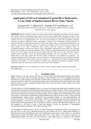
  • 4. Application of GIS in Evaluation of Coastal… www.ijesi.org 57 | Page (II) Integration and manipulation of Bathymetric Data to GIS Medium The attribute spatial data of the study area was integrated into ArcGIS 10 software. Firstly, the bathymetric data (x,y,h) were exported to ArcGIS 10 software in ESRI shape format. Then, adigital water depth model of the study area was produced using the TIN (Triangulated IrregularNetwork) and the 2D Analyst module. The initial river bed was modelled showing existing water depth, with indication of sections deeper and shallower than 8m. Different scenarios were then created from the given attribute data in different layers. A chart showing section with water depth less than 8m, which will require dredging, was created. Then,another chart with a recommended uniform water depth of about 12m was created with the computation of volume of anticipated dredged material to be removed for a width of 200m. Figure 2:- Composite Water Depth Chart of Opobo Channel (IkotAbasi to the Estuary) Figure 3:- Composite Water DepthProfile of Opobo Channel (IkotAbasi to the Estuary)
  • 5. Application of GIS in Evaluation of Coastal… www.ijesi.org 58 | Page IV. RESULTS AND DISCUSSION Within the scope of this study, digital water depth models and bathymetric chart of Opobo Channel was obtained using ArcGIS 10 software (Figure 3.1 and 3.2).The available water depth that will support safe navigation and possible dredging requirement, including dredged volumes were examined using the ArcGIS 10 utilities. These results showed reduced water depth that will not support safe navigation within the channel. About 54% of the channel is shallower than 8m water depth and will require dredging. Due to high sediment dynamics of typical coastal rivers, a threshold of 12m was recommended as uniform dredge limit.Based on this water depth limit, the material volume to be dredged was computed using Cut-and-Fill utility in the GIS software. The volumetric model boundary for the computation was set for 200m width and 14km long. The derived volume of 29,000,000 cubic meters was compared with another computation method using Surface Difference. The correlation was more than 98%. Unfortunately, it was not possible to get the bathymetric data of 1996 dredging works in the channel. This would have enable the evaluation of rate of sedimentation. However, the current bathymetric works will serve as baseline for future assessment and determination of sedimentation rate. With this information, time for subsequent maintenance dredging could be predicted and planned for. Also the anticipated dredge volume will enable budgetary planning. V. CONCLUSIONS The GIS utilities have shown to be a reliable tool for effective management of bathymetric data that will provide a realistic overview of water depth information for safe navigation in Opobo Channel. This is a key decision- making tool for planning the dredging works within the channel. In addition, there is need for continuousstudy and update of hydro-morphological characteristics within the channel and especially around the estuary, which has more sedimentation dynamics. With this continuous information, an updated co-ordinate listing that defines safe route will be made available to mariners/vesselsarriving the channel. Forproper budgetary planning and financial management, the availability of GIS enables a prediction tool, with information on time, volume and cost of future maintenance dredging works. This added value of theGISwill provide a prediction tool with high level of confidence for safe navigation, especially, when one considers the huge cost of vessel beachment. Geographic Information Systems (GIS) technology hasallowed Opobo Channel bathymetry to be two- dimensionally modelled, analyzed and displayed. By deploying such information manipulation tool, the efficiencyand effectiveness of coastal river channel management may be considerably augmented for optimal effect.Once the channel is free for year-round safe navigation, other developmental processes can now key-in. This assures the realization of the ultimate goal of exploring and exploiting the socio-economic potential of IkotAbasi and environ, including Nigeria as a country. Due to multiple influent creeks and creek-lets along the channel, including the downstream estuarine sediment yield, there is need for a detailed morphological research on the evolution of sediment dynamics and characteristics of Opobo Channel. This will bring history to the fore and create a reliable baseline for management of the channel. VI. Acknowledgements The authors would like to thank the Managing Director of SckopemateKonsult Limited, ChigboOkeke (FNIS), for providing and authorizing the use of bathymetric data and charts of Opobo Channel.Also, NwekeChukwuemeka, who, in addition to his very busy schedule, willingly made out time to assist in resourcing technical materials. We thank you all and may God reward you abundantly.
  • 6. Application of GIS in Evaluation of Coastal… www.ijesi.org 59 | Page REFERENCES [1] Lutz, E. and M. Munasinghe (1994),Environmental accounting and valuation in themarine sector. InOcean Governance: Sustainable development of the Seas,edited by Payoyo, P.B., (Tokyo, New York, Paris: United Nations UniversityPress). [2] Eckert, R. D. (979),The Enclosure of Ocean Resources: Economics and the Lawof the Sea, (Stanford: Hoover Institution Press). [3] Erkaya, H., Hoşbaş, R. G. (1998).“Hydrographic Surveying Course Notes”,Yıldız TechnicalUniversity, Geomatic Engineering department, İstanbul. [4] Millett, G. N., Evans, S. (2009). “Hydrographic Data Management Using GIS Technologies.”,Environmental Systems Research Institute, New York, USA. [5] Burrough, P. and McDonnell, R. (1997), Principles of Geographical InformationSystems, (Oxford: Oxford University Press).Carter, R.W.G., 1988, Coastal Environments, [6] Durand H., et al. (1994),An example of GIS potentiality for coastal zonemanagement: Pre-selection of submerged oyster culture areas near MarennesOléron (France).EARSEL Workshop on Remote Sensing and GIS for CoastalZone Management. Delft, The Netherlands, 24 - 26 Oct. [7] Populus J. and Loubersac L. (2000),Geomatics and coastalenvironment. (Brest: Éditions de l‟Ifremer). [8] Wright D. and Bartlett D. (2000),Marine and Coastal Geographical InformationSystems. (London: Taylor and Francis).© 2005 [9] Yomralıoğlu, T. (2005).“Geographic Information Systems: Basic Concepts and Applications.”İBER Ofset Publisher, Trabzon, 32-148.Central Anatolian 12th.District Office of Mineral Research. [10] Wheeler, P. (2005).„Bathymetric Evolution at a Coastal Inlet after Channel-edge GroyneEmplacement‟.Applied GIS, Vol. 1, No. 2, 2005. pp. 28.1–28.34. DOI: 10.2104/ag050028. [11] Nnamah, P. (2005), Baseline Data Determination for the Study of Dynamics of Sediment Redistribution over the Delta Formation at Bonny/Finima River Confluence, Bonny – Nigeria.Unpublished,M.Phil. (Hydrographic Engineering), thesis, Institute of Geoscience and Space Technology, University of Science and Technology Port Harcourt. Nigeria.