Downloaded 40 times

![Journal of Environment and Earth Science www.iiste.org
ISSN 2224-3216 (Paper) ISSN 2225-0948 (Online)
Vol 2, No.8, 2012
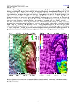
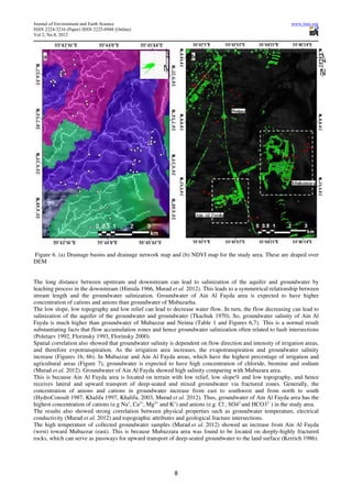
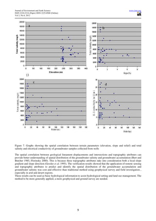
Table 1. Topographic attributes at each groundwater well and corresponding hydrological data collected from
groundwater samples
Topographic attributes at each groundwater well Hydrological analysis of each
groundwater sample [2]
N E Elev.(m) Slope (%) Aspect Relief (m) EC Isosalinity SAR
24.15627 55.69863 245 0.43 294.8 4 5 2200 5
24.10611 55.75008 286.09 1.81 360 60 15 8000 19
24.10112 55.75029 298.35 0.98 90 103 11 7000 18
24.10071 55.75348 324.44 11.25 278.3 184 12 6000 16
24.10228 55.74836 310.4 11.03 69.9 55 16 9000 20
24.10816 55.7499 286.39 2.83 255.2 47 15 8000 19
24.16312 55.71134 250 0.41 208.4 4 6 4000 12
24.16676 55.70859 250.15 0.8 257 5 7 3000 5
24.16012 55.70387 246.46 0.58 199.8 5 5 3100 6
24.16187 55.70241 247.56 0.54 180 4 6 3200 5
24.1569 55.70406 246 5 8 4000 6
24.15921 55.69988 245.55 0.61 287.1 5 5 3000 6
24.15833 55.69957 245.55 0.59 270 5 7 2500 7
24.15424 55.70121 245.19 0.41 208.4 4 6 2000 6
24.15643 55.70103 246.02 0.27 227.2 4 5 2300 8
24.1117 55.7521 292.38 2.52 315.8 53 21 12000 26
24.11625 55.75349 289.55 2.41 283 32 16 8000 18
24.11416 55.7484 284.03 1.23 331.6 25 24 13000 30
24.10601 55.75615 326.9 7.36 287.1 106 5 4100 16
24.1135 55.75719 301.69 3.7 331.6 40 14 7500 19
24.11821 55.75922 294.58 1.29 294.8 21 11 5100 11
24.1175 55.7629 299.76 1.8 300 39 13 5200 10
24.11899 55.7656 313.03 5.96 280.5 72 13 5300 8
24.12132 55.76334 299.39 5.09 265.9 54 8 5000 13
24.10993 55.76936 347.43 6 289.3 86 6 5600 5
24.1244 55.76347 301.56 6.27 275 58 5 5000 15
24.15521 55.69545 244.21 0.67 324.2 5 6 6600 9
24.15346 5.695627 245.25 0.53 312.8 5 4 2000 6
24.15214 55.69644 245.96 0.27 132.8 4 5 2300 5
24.15402 55.69354 243.32 1.12 299 6 6 2100 6
24.15082 55.69613 244.38 0.54 180 6 5 3200 7
24.10073 55.72011 241.35 1.19 261.2 13 4 4000 4
24.09459 55.70469 233 0.27 132.8 5 16 8800 16
24.06922 55.72202 235.39 0.61 252.9 6 27 17000 21
24.08673 55.71243 235 0.27 227.2 10 12 7800 22
24.08704 55.71338 235 0.54 180 10 28 17000 19
24.09218 55.71509 237.24 0.61 252.9 8 22 18000 22
24.09289 55.71205 236.63 0.61 287.1 7 25 16000 16
24.13392 55.70924 241.77 1.04 249.7 8 15 12000 15
24.07387 55.73522 246.7 1.9 247.7 14 11 6000 43
24.07988 55.73453 250.13 1.47 248.4 14 7 7500 14
24.10959 55.72769 250 0.75 195.1 12 8 7600 13
24.13323 55.71388 246.26 1.04 290.3 7 18 8500 25
24.12692 55.71314 246.34 1.38 262.5 8 13 7300 13
24.09052 55.72644 243 0.53 227.2 11 7 4000 17
24.07954 55.72942 242.17 0.59 270 16 11 3500 17
24.11203 55.72112 245.86 1.12 241 9 14 7000 15
24.15232 55.71768 247.05 1.38 238.4 8 12 7400 16
24.14061 55.71956 247 0.27 227.2 5 13 8000 17
10](https://image.slidesharecdn.com/topographicattributescontrolgroundwaterflowandgroundwater-121009022958-phpapp02/85/Topographic-attributes-control-groundwater-flow-and-groundwater-10-320.jpg)
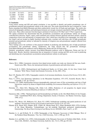


This document summarizes a study that investigated the relationship between topographic attributes and groundwater accumulation and salinity in the southwest part of Al Ain, United Arab Emirates. The study used digital elevation models and remote sensing data to calculate topographic attributes like slope, aspect, relief, and flow accumulation. It found that topographic attributes and hydrological elements are strongly controlled by geological fractures trending northwest and northeast. Areas with high flow accumulation and intersections of geological fractures had greater groundwater accumulation and higher salinity. The study concluded that topographic attributes can help predict sites of high groundwater accumulation and salinity in arid regions.


