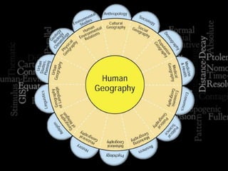
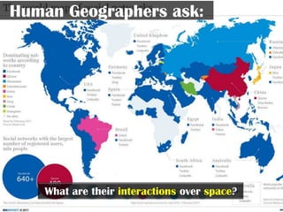
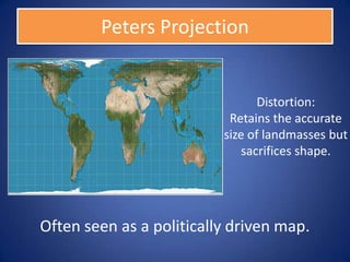
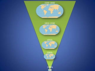
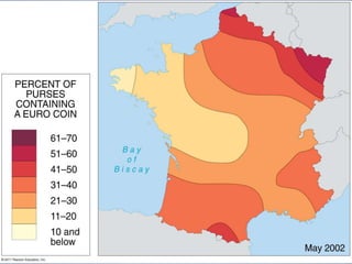
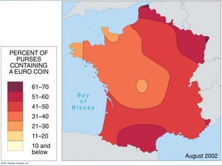
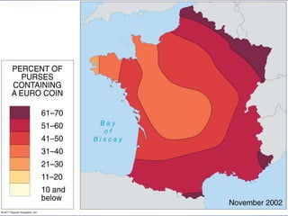
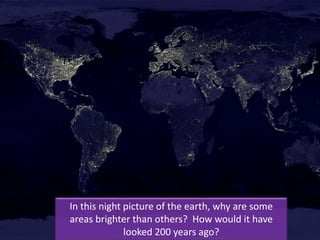
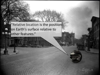
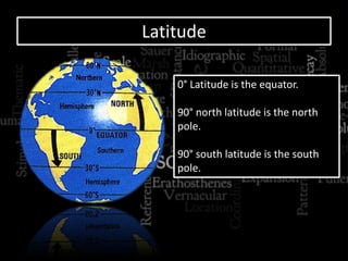
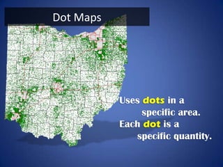
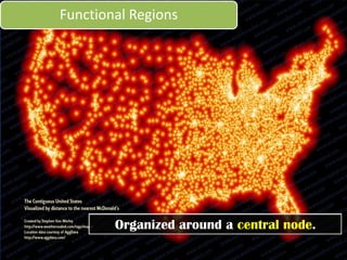
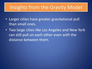
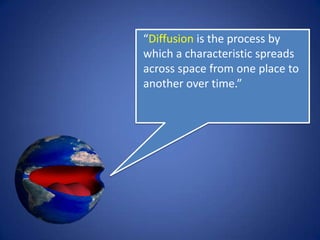
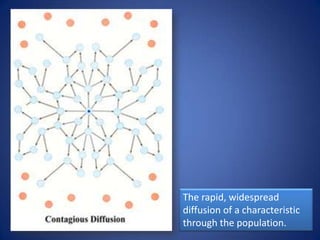
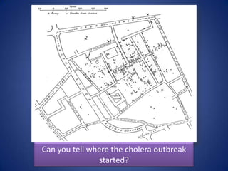
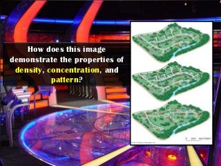
This image demonstrates the properties of density, concentration, and pattern in the following ways:
Density - The number of dots per square unit of space shows the density is highest in the center and decreases moving outwards.
Concentration - The dots are most closely packed together in the center, showing high concentration, and become more dispersed towards the edges, demonstrating lower concentration.
Pattern - The dots are arranged in a circular pattern, with the highest density and concentration forming a circle in the center, and the density and concentration decreasing in concentric circles as you move outwards from the center.
So in summary, this image uses the spatial distribution of dots to illustrate concepts of density, concentration, and pattern that are key to
AP Human Geography: Unit 2 Powerpoint: Population and Migration (Sample)Daniel Eiland
Here is a sample from my Advanced Placement Human Geography Unit 2 Powerpoint I will be using to teach my classes this year. It is on Population and Migration. You can find the full version at http://tinyurl.com/eilandunit2.
Physical Geography Lecture 01 - What Is Geography 092616angelaorr
Introduction to Physical Geography. What is Geography? 5 Fundamental spatial concepts of Geography. Geography is holistic. Subdivisions of Geography. Systems science. Earth's 4 spheres. Review.
Geography is an interesting subject for all. It deals with location, space, patterns and distribution of life, landforms, resources, environment and development. Human geography is the study of human use and understanding of the whole world and the processes which have affected it. This module explains about the importance of human geography.
In broad terms, cultural geography examines the cultural values, practices, discursive and material expressions and artefacts of people, the cultural diversity and plurality of society.
It also emphasizes on how cultures are distributed over space, how places and identities are produced, how people make sense of places and build senses of place, and how people produce and communicate knowledge and meaning.
By going through this presentation, students will be able to understand the diversity within Geography. Introductory and comprehensive details have been given about each branch of Geography.
AP Human Geography: Unit 3 - Cultural Geography: Part 1 SampleDaniel Eiland
This sample of Part 1 of the AP Human Geography Unit 3 Powerpoint includes 114 slides of information introducing concepts of culture, popular culture, and folk culture. It includes maps, higher-order thinking questions, vocabulary words, mind-mapping tools, and other resources to help educate your students on all of the necessary concepts for the AP Test.
Topics Covered: Cultural Geography, Cultural Ecology, Cultural Landscapes, Environmental Determinism, Possibilism, Environmental Perception, Cultural Determinism, Cultural Traits, Cultural Complex, Culture System, Culture Region, Cultural Realm, Cultural Hearths, Independent Inventions, Folk Culture Regions, Indigenous Cultures, Folk Music, Folk Architecture, Effects of Popular Culture and many others.
This is a revised & updated version of a really great resource to help Geography teachers start the new year in style. As always, any comments & feedback is really useful.
Thanks, simon
Lets start off the new school year in style! This is a re-imagining of an older resource designed to introduce the subject to new students in a highly visual manner. Feel free to use & share it. Check out the links.
As always, any feedback would be really useful.
Thanks, Simon
What is Geophagy?
Themes of Geography
Traditions of Geography
Tools of Geography.
• MAPS
• ATLAS
• GLOBE
• AERIAL PHOTOGRAPHS
• SATELLITE PHOTOGRAPHS
• INFORMATION GRAPHICS
• GEOGRAPHIC INFORMATION SYSTEM
Cartography is the science of map making related to geography, mathematics, geodesy, and human habitat, economy and society. Its a discipline developed during the early period of human civilization. With the development of science and technology, it has changed its paradigm twice. Its been digital, more integrated and very useful global media for communication.
Data analysis in geography simply concerns the methodology for collecting, analyzing, and presenting data. It frequently involves the application of statistical techniques useful in several ways ― first, these help summarize the findings of studies (example: total rainfall during a period in a state), second, these help understanding of the phenomenon under study (example: rainfall is more in the southern districts), third, these help forecast the state of variables (example: draught is likely during the next year), fourth, these help evaluate performance of certain activity (example: more rainfall means more rice production), fifth, these help decision making (example: finding out the best location for a H.S. School), sixth, they also help to establish whether relationships between the characteristics of a set of observations are genuine or not, and finally, certainly all these can show that the results of the analysis make a valuable contribution to the body of geographical knowledge.
Statistical techniques and procedures are applied in all fields of academic research; wherever data are collected and summarized or wherever any numerical information is analyzed or research is conducted, statistics are needed for sound analysis and interpretation of results. Geographers primarily use statistics in the following ways: to describe and summarize spatial data, to make generalizations concerning complex spatial patterns, to estimate the probability of outcomes for an event at a given location, to use samples of geographic data to infer characteristics for a larger set of geographic data (population), to determine if the magnitude or frequency of some phenomenon differs from one location to another, and to learn whether an actual spatial pattern matches some expected pattern.
The French Revolution, which began in 1789, was a period of radical social and political upheaval in France. It marked the decline of absolute monarchies, the rise of secular and democratic republics, and the eventual rise of Napoleon Bonaparte. This revolutionary period is crucial in understanding the transition from feudalism to modernity in Europe.
For more information, visit-www.vavaclasses.com
How to Split Bills in the Odoo 17 POS ModuleCeline George
Bills have a main role in point of sale procedure. It will help to track sales, handling payments and giving receipts to customers. Bill splitting also has an important role in POS. For example, If some friends come together for dinner and if they want to divide the bill then it is possible by POS bill splitting. This slide will show how to split bills in odoo 17 POS.
Ethnobotany and Ethnopharmacology:
Ethnobotany in herbal drug evaluation,
Impact of Ethnobotany in traditional medicine,
New development in herbals,
Bio-prospecting tools for drug discovery,
Role of Ethnopharmacology in drug evaluation,
Reverse Pharmacology.
Read| The latest issue of The Challenger is here! We are thrilled to announce that our school paper has qualified for the NATIONAL SCHOOLS PRESS CONFERENCE (NSPC) 2024. Thank you for your unwavering support and trust. Dive into the stories that made us stand out!
2024.06.01 Introducing a competency framework for languag learning materials ...Sandy Millin
http://sandymillin.wordpress.com/iateflwebinar2024
Published classroom materials form the basis of syllabuses, drive teacher professional development, and have a potentially huge influence on learners, teachers and education systems. All teachers also create their own materials, whether a few sentences on a blackboard, a highly-structured fully-realised online course, or anything in between. Despite this, the knowledge and skills needed to create effective language learning materials are rarely part of teacher training, and are mostly learnt by trial and error.
Knowledge and skills frameworks, generally called competency frameworks, for ELT teachers, trainers and managers have existed for a few years now. However, until I created one for my MA dissertation, there wasn’t one drawing together what we need to know and do to be able to effectively produce language learning materials.
This webinar will introduce you to my framework, highlighting the key competencies I identified from my research. It will also show how anybody involved in language teaching (any language, not just English!), teacher training, managing schools or developing language learning materials can benefit from using the framework.
The Indian economy is classified into different sectors to simplify the analysis and understanding of economic activities. For Class 10, it's essential to grasp the sectors of the Indian economy, understand their characteristics, and recognize their importance. This guide will provide detailed notes on the Sectors of the Indian Economy Class 10, using specific long-tail keywords to enhance comprehension.
For more information, visit-www.vavaclasses.com
14. Aristotle (384 BCE – 322 BCE)
I was the first person
to demonstrate that
the Earth was
spherical.
15. Eratosthenes (3rd Century BCE)
I accurately calculated
the circumference of
the earth using
geometry and was the
first known person to
use the word
geography.
16.
17. Claudius Ptolemy (CE 90 – CE 168)
I wrote a book called
Geography and
designed the
forerunner to
longitude and
latitude lines.
18.
19. Abu Abd Allah Muhammad al-Idrisi al-Qurtubi al-Hasani al-Sabti
Al Idrisi (1099–1165)
I’m an Arabic
geographer who
worked for the King of
Sicily to create an
accurate
representation of the
world.
23. George Perkins Marsh (1801-1882)
I first described how
natural systems are
impacted by human
actions. I am considered
the first modern
environmentalist
24. Carl Sauer (1889-1975)
In 1925, I argued that
cultural landscapes, the
interactions between
people and their
environment, should be
the focus of geographic
study.
25. How did the maps change between
Eratosthenes and Ortelius? Why?
41. Qualitative Data
Examines cultural or regional Uses rigorous mathematical
geography. techniques to examine hard
Gathered through numerical data.
observations, interviews, and
the interpretations of texts.
Quantitative Data
42. Idiographic
Facts and Concepts that
figures unique are universally
to a particular applicable
place or
region
Nomothetic
76. “Latitude is the numbering
system that enumerates
parallels, circles drawn around
the globe parallel to the
equator and at right angles to
the meridians.”
77. Latitude
0° Latitude is the equator.
90° north latitude is the north
pole.
90° south latitude is the south
pole.
81. “The International Date Line is an
imaginary line on the surface of the
Earth, that runs from the north to
the south pole and demarcates one
calendar day from the next.”
82. A traveler crossing the
International Date Line
eastbound subtracts
one day, or 24 hours, so
that the calendar date
to the west of the line
is repeated.
97. For Your Consideration
Imagine that you are a researcher using GIS to
determine information. What is a question that
you might be able to answer using the
technologies available?
142. “Movement is the way that
people, products, information
and ideas move from one place
to another.”
143. Compare how long it would take you to get
from school to the mall (6.2 Miles) using
the following forms of transportation.
1) Walking (3.1 MPH)
2) Horse (15 MPH)
3) Car (45 MPH)
4) Helicopter (100 MPH)
144. How has the time it takes to travel
changed through the years? Why?
158. “The Gravity Model says that
the interaction between two
places is equal to the product
of the places’ population
divided by the square of their
distance apart.”
160. Insights from the Gravity Model
1) Larger cities have greater gravitational pull
than small ones.
2) Two large cities like Los Angeles and New York
can still pull on each other even with the
distance between them.
166. Core: The “most pure” area
that possesses all cultural
traits used to define a region.
Domain: The area in which the
culture is dominant but less
intense.
Sphere: The zone of outer
influence where people with
the culture traits can even be a
minority in another region.
187. How does the
big affect the
small?
What
characteristics
of the small are
Scale How does the
small affect the
characteristics
of the big? Asks big?
What
characteristics
of the big are
part of the
small?
188. How does your perception of cancer rates change
when you look at a country and state level map?
196. “Human-Environmental
Interaction is how humans
modify, adapt to, and depend
on their environment. Cultural
Ecology is the study of human-
environment relationships.”
197. Environmental Determinism
How a People have
physical the ability to
environment adjust to
causes social their
development. environment.
Possibilism