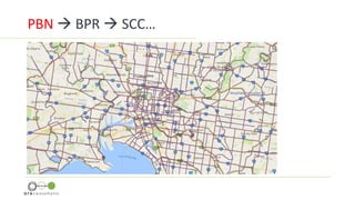
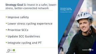
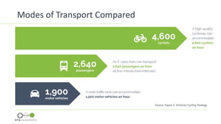
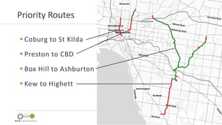
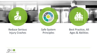
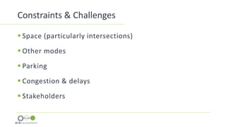
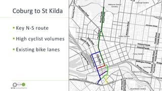
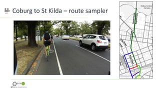
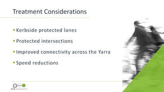
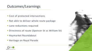
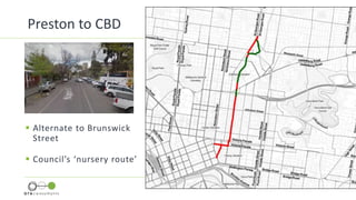
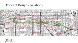
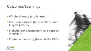
Strategic Cycling Corridors
How are we travelling?
Phil Gray
AITPM Conference, Perth | July 2018
Image: Dissing+WeitlingArchitects
Cycling Utopia?
 Victorian Cycling Strategy
 Catalyst for works (TAC & VicRoads)
 GTA project involvement
 Process and Outcomes
 Learnings
Content
PBN  BPR  SCC…
 $100 million Safer Cyclists
and Pedestrian Fund
 Election commitment
 Includes regional locations
Funding
Strategy Goal 1: Invest in a safer, lower-
stress, better-connected network
 Improve safety
 Lower stress cycling experience
 Prioritise SCCs
 Update SCC Guidelines
 Integrate cycling and PT
Modes of Transport Compared
Source: Figure 5, Victorian Cycling Strategy
Priority Routes
 Coburg to St Kilda
 Preston to CBD
 Box Hill to Ashburton
 Kew to Highett
Reduce Serious
Injury Crashes
Safe System
Principles
Best Practice, All
Ages & Abilities
Constraints & Challenges
 Space (particularly intersections)
 Other modes
 Parking
 Congestion & delays
 Stakeholders
Coburg to
St Kilda
Project Example
 Key N-S route
 High cyclist volumes
 Existing bike lanes
Coburg to St Kilda
Coburg to St Kilda – route sampler
 Kerbside protected lanes
 Protected intersections
 Improved connectivity across the Yarra
 Speed reductions
Treatment Considerations
‘Dutch Experts’
Protected Intersection
CONCEPT ONLY
Protected Intersection
CONCEPT ONLY
 Cost of protected intersections
 Not able to deliver whole route package
 Lane reductions required
 Directness of route (Spencer St vs William St)
 Haymarket Roundabout
 Heritage on Royal Parade
Outcomes/Learnings
Preston to
CBD
Project Example
Preston to CBD
 Alternate to Brunswick
Street
 Council’s ‘nursery route’
Concept Design - Locations
Protected Intersection
CONCEPT ONLY
4m1.7m 1.7m
Bicycle Boulevard Concept Development
Bicycle Boulevard
Signalised Intersection
CONCEPT ONLY
Signalised Crossing
CONCEPT ONLY
 Whole of route (study area)
 Focus on barriers (intersections) and
bicycle priority
 Stakeholder engagement and support
important
 Route connectivity (beyond the CBD)
Outcomes/Learnings
How are we travelling?
• Process has started
• Coordinated approach req
• A lot more to do
What is Stopping Us?
 Political will and commitment
 Tough decisions regarding prioritising cycling as a
preferred mode
 The way we allocate road space – car-dominant
 Funding – investment in infrastructure planning and
resourcing ATV
Strategic Cycling Corridors in Melbourne
How are we travelling?
Phil Gray
(Vulnerable Road User Program Coordinator)
Phil.Gray@roads.vic.gov.au
Thank You

AITPM Conference Presentation - phil gray

Editor's Notes

  • #2 Introduce myself (transport engineer specialising in active transport and road safety projects – also a regular commuter cyclist) Today I will be discussing some work that GTA completed on Strategic Cycling Corridors in Melbourne. The work was completed for VicRoads – who I am now working for
  • #3 Melbourne is planning for a cycling renaissance through the establishment of a metropolitan-wide network of high quality strategic cycling corridors. This is an ambitious approach with a large-scale network. If delivered in its entirety it would provide the framework for a truly connected commuter network and pave the way for the prioritisation of cycling infrastructure and the beginning of a truly liveable city! While we are long way from reaching Danish cycling nirvana, the cycling conversation is beginning to escalate and that can only be a good thing.
  • #4 This presentation asks the question of whether Melbourne is ready to make this level of commitment – both at a political and financial level In considering the question I will provide an overview of my involvement working in the feasibility and design of selected SCCs The general content I will cover is shown here, beginning with some context around the derivation of SCCs, the catalyst for GTA’s involvement, examples of the design outputs and some of the learnings from the work
  • #5 First a quick lesson in acronyms and cycle network naming in Melbourne… The overarching network is the Principal Bicycle Network which is a network of existing and proposed cycle routes identified to help people ride to major destinations around metropolitan Melbourne. A subset of the PBN is the Bicycle Priority Routes (BPR) which are priority sections identified in VicRoads SmartRoads that should be elevated to a higher order of priority. The SCC’s are also a sub-set of the PBN and have been identified as part of the initiative in Plan Melbourne to ‘Support Walking and Cycling in Central Melbourne’,. The corridors are developed to improve cycling to and around major activity centres in metropolitan Melbourne and are prioritised on the basis of the corridors that achieve greatest benefits to cyclists and the whole community.
  • #6 SCCs have been developing in collaboration with Councils over the past four years or so, but it was not until funding became available through the $100 million Safer Cyclists and Pedestrians Fund that actual feasibility and designs commenced on selected corridors. Through this fund, VicRoads and the TAC were tasked with prioritising and investing in safe system infrastructure that keeps cyclists and pedestrians safe.
  • #7 Other items include: Work with Councils to address SCC gaps Cycling infrastructure in major transport projects Improve outcomes for cyclists in planning
  • #9 GTA was engaged to complete feasibility studies of discreet sections of four SCCs – two inner city routes and two in the outer eastern suburbs:   Preston to CBD Coburg to St Kilda Kew to Highett Box Hill to Ashburton The routes were pre-determined by VicRoads using a MCA  Long sections of the outer suburban routes included off-road shared paths and the focus was on the treatment of the road crossings, however the inner city routes were primarily on-road and are the focus of this presentation. While the complete routes are quite long, due to various constraints (including time and money), a focus was given to addressing the challenges associated within the CBD.
  • #10 Goals To reduce the occurrence of serious injury crashes, while balancing the requirements of all network users Apply Safe System principles with a focus on achieving physical separation or shared roads with low speed/volumes Follow best practice design principles and seek to cater for users of all ages and abilities
  • #11 To create separated facilities in a constrained CBD environment presents significant challenges: Space (within the road reservation and particularly at intersections) Other modes – primarily trams and cars, but also buses and pedestrians Increased congestion and delays – it is noted that the Councils were generally happy with increased delays Multiple stakeholders involved, including PTV, VicRoads, TAC, ATV, SSRIP, Yarra Trams, Councils
  • #13 Characteristics include: High cyclist volumes Existing buffered bike lanes on some sections Key N-S Route to CBD Main Constraints are: Intersections (includes Haymarket roundabout and lack of space makes it difficult to provide physical protection) Heritage overlays on Royal Parade CBD route alignment – multiple options including future changes along Spencer Street (to be more pedestrian-focussed) Connections south of Yarra River – no established safe routes
  • #16 To assist in the options development and to gain some international insights, VicRoads brought over Dutch cycling ‘experts’ who shared their design experience during a workshop for developing a protected intersection. Discuss main treatment approaches: Initially kerbside protected bike lanes, but these were subsequently only proposed on Spencer Street Protected intersections – considered a key opportunity to trial one of these at Clarendon Street/Whiteman Street Improvements to the connectivity at the river, however the ultimate route alignment was questioned Dutch ‘experts’ were brought over from VicRoads and they shared design experience during a workshop for developing a protected intersection
  • #19 In the end, due to the various challenges, the high cost of the works, the relatively low crash history at the treatment sites and the fact that the treatments were not a continuous corridor treatment – the treatments for this route were not funded.
  • #21 Characteristics High cyclist volumes Existing well-used shared path and low volume, low speed roads Main Constraints are: Space constraints on St Georges Road and connection with St Georges Road shared path Intersections – unsignalised crossings of arterial roads (Queens Parade and Gertrude Street in particular), and unprotected intersections CBD route alignment – no good east-west connections once route hits Spring Street
  • #22 The main treatments adopted for this route include: Retention of the existing shared path to the north New cycle crossing at the St Georges Road intersection Bicycle boulevard style line marking treatments with improvements to local roundabouts and side entry treatments New signalised intersections Protected intersections
  • #23 Albert St/Lansdowne St Achieved by removing an off-peak traffic lane in the N-S direction and includes removal of separate, short left-turn lanes on the Albert Street approaches to provide a continuous separated treatment.
  • #24 One of the ideas for creating more of a bike boulevard Buffered line marking with contrasting surface to narrow road and provide protection from parked cars Remove centre line Bike priority (vehicles to use buffered areas to pass Not preferred by Council, since route is used as a ‘nursery route’ and riders may not feel as comfortable riding in the narrow centre lane and might choose to ride in the buffered area
  • #30 Commitment from the top-down There can also be a tendency to bundle cycle projects with major infrastructure projects (e.g. EastLink and West Gate Tunnel proposal) rather than provide them on their own merits and the health benefits to be achieved