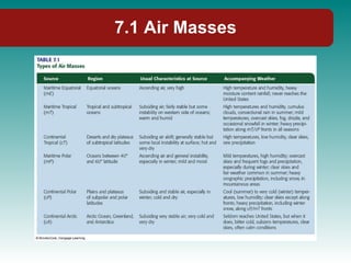
Chapter 7: Air Masses and Weather Systems Physical Geography Ninth Edition Robert E. Gabler James. F. Petersen L. Michael Trapasso Dorothy Sack
Ch. 7: Air Masses and Weather Systems
7.1 Air Masses Air Mass: large body of air whose temperature and moisture characteristics are similar. Due to General Atmospheric Circulation, air masses move and cause changing weather. Source Region: m = maritime (sea) c = continental (land) E = Equatorial (very warm) T = Tropical (warm) P = Polar (cold) A = Arctic (very cold)
7.1 Air Masses
7.1 Air Masses Q: Which air mass affect your location?  Are there seasonal variations?
7.1 Air Masses Air Mass Modification cP or CA moves over Great Lakes and picks up moisture, and may cause Lake effect snow.
7.1 Air Masses Continental Arctic (cA): Dry and very cold occasionally impacts U.S. in the winter it often produces record breaking cold. Continental Polar (cP): Dry and cold.  May reach Gulf of Mexico in winter.  Rarely affects west coast.  Maritime Polar (mP): moist and cool Westerlies bring air mass to west coast, especially in winter.  Occasionally affects east U.S.
7.1 Air Masses Maritime Tropical (mT): moist and warm May originates in Gulf of Mexico Major impact on central and eastern U.S T-storms in the summer Clashes with cP Continental Tropical (cT): dry and hot Small source region (SW deserts and N. Mexico Dry line Smallest player in U.S. weather
7.2 Fronts Fronts clash between air masses Generally move with westerlies 3-dimensional Frontal uplift
7.2 Fronts Cold Front: Cold air moves in on warm air Warm air (less dense) rises above cold air Steep slope Cumulonimbus may form a Squall line Sharp changes in temperature, pressure, and wind
7.2 Fronts Warm Front: Warm air moves in on cooler air Warm air (less dense) rises above cold air Slope is not as steep Light precipitation which may last longer Usher in warmer conditions
7.2 Fronts Stationary Front Boundary between air masses that is not moving Extended period of light precipitation and occasionally strong T-storms Occluded Front Cold air is overtaking warm air Dying storm
7.2 Fronts Four Major Frontal Symbols used on weather maps.
7.3 Atmospheric Disturbances Middle Latitude Cyclones Common location for a clash between cold, polar air and warm, subtropical air Convergence Guided by polar jet stream Variable weather
7.3 Atmospheric Disturbances Cyclones (L) Move with jet stream/westerlies Converging, rising air Fronts Precipitation Anticyclone (H) Move with path of westerlies Divergence, sinking air Dry weather
7.3 Atmospheric Disturbances Horizontal and Vertical Structure of pressure systems Where would the strongest and weakest winds be?
7.3 Atmospheric Disturbances Common track of storms (mid-latitude cyclones) What storm track (jet stream) influences your location?
7.3 Atmospheric Disturbances Stages in the development of a mid-latitude cyclone Q: Where would you expect precipitation.  Why?
7.3 Atmospheric Disturbances Cyclones and Local Weather Q: Describe the front(s), temp, air mass type, wind direction, and precip. at Des Moines, St Louis, and Pittsburg.
7.3 Atmospheric Disturbances Cyclones and Upper Air Flow Polar jet stream Major impact on temperature and precip. Q: Where would you expect storms to develop?
7.3 Atmospheric Disturbances Polar Jet Stream Analysis Anticyclones Q: Which country does most of this pattern occupy?  Where is an anticyclone?
7.3 Atmospheric Disturbances Hurricanes Circular, cyclonic storm with wind speeds greater than 74 mph (118 km/hr) Smaller than mid-latitude cyclone Same air mass type More destructive Also called tropical cyclones
7.3 Atmospheric Disturbances Cross section of a hurricane
7.3 Atmospheric Disturbances Storm Surge Q: Why is the timing of landfall so critical to coastal areas?
7.3 Atmospheric Disturbances Major “Hurricane Alleys” Which coastlines seem unaffected by these tracks?
7.3 Atmospheric Disturbances Hurricane development Warm water (>25 o C or 77 o F) Most air Coriolis force (do not form or survive near equator) Stages of Development Tropical disturbance Tropical depression Tropical Storm (become named) Hurricane (categorized by Saffir-Simpson Scale)
7.3 Atmospheric Disturbances Saffir-Simpson Scale
7.3 Atmospheric Disturbances Three hurricane tracks Subtropical High (Bermuda High)
7.3 Atmospheric Disturbances Hurricane Strikes Q: What areas of our coasts seem to have escaped landfall?
7.3 Atmospheric Disturbances Snow Storms and blizzards Mid and high latitudes Blizzard Severe weather event Heavy snow and strong winds (55 km/hr or 35 mph) Visibility reduced
7.3 Atmospheric Disturbances Thunderstorms Low and mid latitudes Lightning: intense discharge of electricity Thunder: sonic boom created by the expansion of air around the lightning bolt Usually cover a small area
7.3 Atmospheric Disturbances Types of Thunderstorms Convective (thermal) Orographic Frontal
7.3 Atmospheric Disturbances Tornadoes Occur almost anywhere but are most common in North America (Tornado Alley) Small intense, cyclonic storm of low pressure, violent winds, and converging air
7.3 Atmospheric Disturbances Destruction caused by an F5 tornado in Greensburg, Kansas on May 16, 2007
7.3 Atmospheric Disturbances Average annual # of tornadoes  and seasonal variation
7.3 Atmospheric Disturbances Doppler radar: improves tornado detection and forecasting Able to determine wind speed and direction Q: How many squall lines can you see on this image?
7.3 Atmospheric Disturbances Fujita Scale (F-0 to F-5) Enhanced Fujita Scale (EF-0 to EF-5)
7.3 Atmospheric Disturbances Weak tropical Disturbances Easterly Wave Polar Outbreak
7.3 Atmospheric Disturbances Weather Forecasting Doppler radar Weather satellites (e.g. GOES East) High speed computers Improving!
Physical Geography End of Chapter 7: Air Masses and Weather Systems

7

  • 1.
    Chapter 7: AirMasses and Weather Systems Physical Geography Ninth Edition Robert E. Gabler James. F. Petersen L. Michael Trapasso Dorothy Sack
  • 2.
    Ch. 7: AirMasses and Weather Systems
  • 3.
    7.1 Air MassesAir Mass: large body of air whose temperature and moisture characteristics are similar. Due to General Atmospheric Circulation, air masses move and cause changing weather. Source Region: m = maritime (sea) c = continental (land) E = Equatorial (very warm) T = Tropical (warm) P = Polar (cold) A = Arctic (very cold)
  • 4.
  • 5.
    7.1 Air MassesQ: Which air mass affect your location? Are there seasonal variations?
  • 6.
    7.1 Air MassesAir Mass Modification cP or CA moves over Great Lakes and picks up moisture, and may cause Lake effect snow.
  • 7.
    7.1 Air MassesContinental Arctic (cA): Dry and very cold occasionally impacts U.S. in the winter it often produces record breaking cold. Continental Polar (cP): Dry and cold. May reach Gulf of Mexico in winter. Rarely affects west coast. Maritime Polar (mP): moist and cool Westerlies bring air mass to west coast, especially in winter. Occasionally affects east U.S.
  • 8.
    7.1 Air MassesMaritime Tropical (mT): moist and warm May originates in Gulf of Mexico Major impact on central and eastern U.S T-storms in the summer Clashes with cP Continental Tropical (cT): dry and hot Small source region (SW deserts and N. Mexico Dry line Smallest player in U.S. weather
  • 9.
    7.2 Fronts Frontsclash between air masses Generally move with westerlies 3-dimensional Frontal uplift
  • 10.
    7.2 Fronts ColdFront: Cold air moves in on warm air Warm air (less dense) rises above cold air Steep slope Cumulonimbus may form a Squall line Sharp changes in temperature, pressure, and wind
  • 11.
    7.2 Fronts WarmFront: Warm air moves in on cooler air Warm air (less dense) rises above cold air Slope is not as steep Light precipitation which may last longer Usher in warmer conditions
  • 12.
    7.2 Fronts StationaryFront Boundary between air masses that is not moving Extended period of light precipitation and occasionally strong T-storms Occluded Front Cold air is overtaking warm air Dying storm
  • 13.
    7.2 Fronts FourMajor Frontal Symbols used on weather maps.
  • 14.
    7.3 Atmospheric DisturbancesMiddle Latitude Cyclones Common location for a clash between cold, polar air and warm, subtropical air Convergence Guided by polar jet stream Variable weather
  • 15.
    7.3 Atmospheric DisturbancesCyclones (L) Move with jet stream/westerlies Converging, rising air Fronts Precipitation Anticyclone (H) Move with path of westerlies Divergence, sinking air Dry weather
  • 16.
    7.3 Atmospheric DisturbancesHorizontal and Vertical Structure of pressure systems Where would the strongest and weakest winds be?
  • 17.
    7.3 Atmospheric DisturbancesCommon track of storms (mid-latitude cyclones) What storm track (jet stream) influences your location?
  • 18.
    7.3 Atmospheric DisturbancesStages in the development of a mid-latitude cyclone Q: Where would you expect precipitation. Why?
  • 19.
    7.3 Atmospheric DisturbancesCyclones and Local Weather Q: Describe the front(s), temp, air mass type, wind direction, and precip. at Des Moines, St Louis, and Pittsburg.
  • 20.
    7.3 Atmospheric DisturbancesCyclones and Upper Air Flow Polar jet stream Major impact on temperature and precip. Q: Where would you expect storms to develop?
  • 21.
    7.3 Atmospheric DisturbancesPolar Jet Stream Analysis Anticyclones Q: Which country does most of this pattern occupy? Where is an anticyclone?
  • 22.
    7.3 Atmospheric DisturbancesHurricanes Circular, cyclonic storm with wind speeds greater than 74 mph (118 km/hr) Smaller than mid-latitude cyclone Same air mass type More destructive Also called tropical cyclones
  • 23.
    7.3 Atmospheric DisturbancesCross section of a hurricane
  • 24.
    7.3 Atmospheric DisturbancesStorm Surge Q: Why is the timing of landfall so critical to coastal areas?
  • 25.
    7.3 Atmospheric DisturbancesMajor “Hurricane Alleys” Which coastlines seem unaffected by these tracks?
  • 26.
    7.3 Atmospheric DisturbancesHurricane development Warm water (>25 o C or 77 o F) Most air Coriolis force (do not form or survive near equator) Stages of Development Tropical disturbance Tropical depression Tropical Storm (become named) Hurricane (categorized by Saffir-Simpson Scale)
  • 27.
    7.3 Atmospheric DisturbancesSaffir-Simpson Scale
  • 28.
    7.3 Atmospheric DisturbancesThree hurricane tracks Subtropical High (Bermuda High)
  • 29.
    7.3 Atmospheric DisturbancesHurricane Strikes Q: What areas of our coasts seem to have escaped landfall?
  • 30.
    7.3 Atmospheric DisturbancesSnow Storms and blizzards Mid and high latitudes Blizzard Severe weather event Heavy snow and strong winds (55 km/hr or 35 mph) Visibility reduced
  • 31.
    7.3 Atmospheric DisturbancesThunderstorms Low and mid latitudes Lightning: intense discharge of electricity Thunder: sonic boom created by the expansion of air around the lightning bolt Usually cover a small area
  • 32.
    7.3 Atmospheric DisturbancesTypes of Thunderstorms Convective (thermal) Orographic Frontal
  • 33.
    7.3 Atmospheric DisturbancesTornadoes Occur almost anywhere but are most common in North America (Tornado Alley) Small intense, cyclonic storm of low pressure, violent winds, and converging air
  • 34.
    7.3 Atmospheric DisturbancesDestruction caused by an F5 tornado in Greensburg, Kansas on May 16, 2007
  • 35.
    7.3 Atmospheric DisturbancesAverage annual # of tornadoes and seasonal variation
  • 36.
    7.3 Atmospheric DisturbancesDoppler radar: improves tornado detection and forecasting Able to determine wind speed and direction Q: How many squall lines can you see on this image?
  • 37.
    7.3 Atmospheric DisturbancesFujita Scale (F-0 to F-5) Enhanced Fujita Scale (EF-0 to EF-5)
  • 38.
    7.3 Atmospheric DisturbancesWeak tropical Disturbances Easterly Wave Polar Outbreak
  • 39.
    7.3 Atmospheric DisturbancesWeather Forecasting Doppler radar Weather satellites (e.g. GOES East) High speed computers Improving!
  • 40.
    Physical Geography Endof Chapter 7: Air Masses and Weather Systems

Editor's Notes