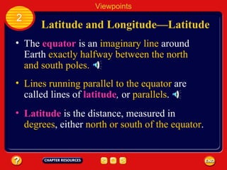
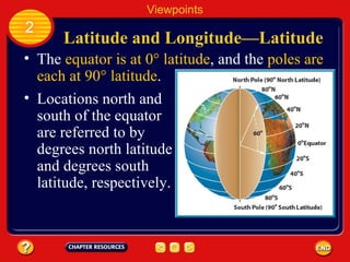
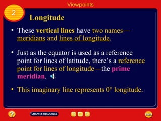
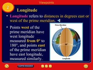
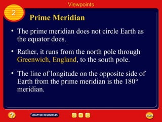
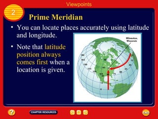
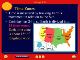
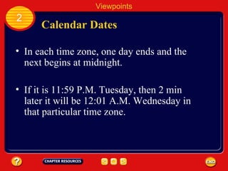
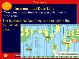
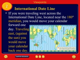
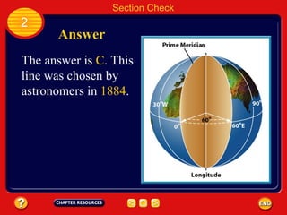
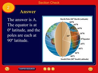
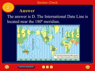
Chapter:  Views of Earth Table of Contents Section 3:  Maps Section 1:  Landforms Section 2:  Viewpoints
Latitude and Longitude —Latitude The  equator   is an  imaginary line  around Earth  exactly halfway between the north and south poles. Lines running parallel to the equator  are called lines of  latitude ,  or  parallels .   Latitude  is the distance, measured in  degrees , either  north or south of the equator . Viewpoints 2
Latitude and Longitude —Latitude The  equator is at 0° latitude , and the  poles are each at 90° latitude . Locations north and south of the equator are referred to by degrees north latitude and degrees south latitude, respectively. Viewpoints 2
Longitude These   vertical lines   have  two names — meridians  and  lines of longitude . Just as the equator is used as a reference point for lines of latitude, there’s a  reference point for lines of longitude— the  prime meridian . Viewpoints 2 This imaginary line represents 0° longitude.
Longitude Longitude  refers to  distances in degrees east or west of the prime meridian . Viewpoints 2 Points  west  of the prime meridian have west longitude measured  from 0°  to 180°, and points  east  of the prime meridian have east longitude, measured similarly.
Prime Meridian The prime meridian does not circle Earth as the equator does. Viewpoints 2 Rather, it runs from the north pole through  Greenwich, England , to the south pole. The line of longitude on the opposite side of Earth from the prime meridian is the 180° meridian.
Prime Meridian You can locate places accurately using latitude and longitude. Viewpoints 2 Note that  latitude position always comes first  when a location is given.
Time Zones Time is measured by tracking Earth’s movement in relation to the Sun. Viewpoints 2 Each day has 24 h, so Earth is divided into 24 time zones.   Each time zone is about 15° of longitude wide.
Calendar Dates In each time zone, one day ends and the next begins at midnight. Viewpoints 2 If it is 11:59 P.M. Tuesday, then 2 min later it will be 12:01 A.M. Wednesday in that particular time zone.
International Date Line You gain or lose time when you enter a new time zone. Viewpoints 2 The International Date Line is the transition line  for calendar days.
International Date Line Viewpoints 2 If you were traveling west across the International Date Line, located near the  180 °  meridian , you would move your calendar  forward one day.  Traveling east, (against the sun) you would move your calendar back one day.
Section Check 2 Question 1 The imaginary line representing 0º longitude is the ________. A. equator B. International Date Line C. prime meridian D. time zone transition line
Section Check 2 Answer The answer is  C . This line was chosen by astronomers in  1884 .
Section Check 2 Question 2 What imaginary line separates Earth into the northern and southern hemispheres? A. equator B. International Date Line C. prime meridian D. time zone transition line
Section Check 2 Answer The answer is A. The equator is at 0º latitude, and the poles are each at 90º latitude.
Section Check 2 Question 3 What location is nearest to the transition line for calendar days? A. 0º latitude B. 0º longitude C. 180º latitude D. 180º meridian
Section Check 2 Answer The answer is D. The International Date Line is located near the 180º meridian.

Chapter 2:2 Views of Earth- Viewpoints

  • 1.
  • 2.
    Chapter: Viewsof Earth Table of Contents Section 3: Maps Section 1: Landforms Section 2: Viewpoints
  • 3.
    Latitude and Longitude—Latitude The equator is an imaginary line around Earth exactly halfway between the north and south poles. Lines running parallel to the equator are called lines of latitude , or parallels . Latitude is the distance, measured in degrees , either north or south of the equator . Viewpoints 2
  • 4.
    Latitude and Longitude—Latitude The equator is at 0° latitude , and the poles are each at 90° latitude . Locations north and south of the equator are referred to by degrees north latitude and degrees south latitude, respectively. Viewpoints 2
  • 5.
    Longitude These vertical lines have two names — meridians and lines of longitude . Just as the equator is used as a reference point for lines of latitude, there’s a reference point for lines of longitude— the prime meridian . Viewpoints 2 This imaginary line represents 0° longitude.
  • 6.
    Longitude Longitude refers to distances in degrees east or west of the prime meridian . Viewpoints 2 Points west of the prime meridian have west longitude measured from 0° to 180°, and points east of the prime meridian have east longitude, measured similarly.
  • 7.
    Prime Meridian Theprime meridian does not circle Earth as the equator does. Viewpoints 2 Rather, it runs from the north pole through Greenwich, England , to the south pole. The line of longitude on the opposite side of Earth from the prime meridian is the 180° meridian.
  • 8.
    Prime Meridian Youcan locate places accurately using latitude and longitude. Viewpoints 2 Note that latitude position always comes first when a location is given.
  • 9.
    Time Zones Timeis measured by tracking Earth’s movement in relation to the Sun. Viewpoints 2 Each day has 24 h, so Earth is divided into 24 time zones. Each time zone is about 15° of longitude wide.
  • 10.
    Calendar Dates Ineach time zone, one day ends and the next begins at midnight. Viewpoints 2 If it is 11:59 P.M. Tuesday, then 2 min later it will be 12:01 A.M. Wednesday in that particular time zone.
  • 11.
    International Date LineYou gain or lose time when you enter a new time zone. Viewpoints 2 The International Date Line is the transition line for calendar days.
  • 12.
    International Date LineViewpoints 2 If you were traveling west across the International Date Line, located near the 180 ° meridian , you would move your calendar forward one day. Traveling east, (against the sun) you would move your calendar back one day.
  • 13.
    Section Check 2Question 1 The imaginary line representing 0º longitude is the ________. A. equator B. International Date Line C. prime meridian D. time zone transition line
  • 14.
    Section Check 2Answer The answer is C . This line was chosen by astronomers in 1884 .
  • 15.
    Section Check 2Question 2 What imaginary line separates Earth into the northern and southern hemispheres? A. equator B. International Date Line C. prime meridian D. time zone transition line
  • 16.
    Section Check 2Answer The answer is A. The equator is at 0º latitude, and the poles are each at 90º latitude.
  • 17.
    Section Check 2Question 3 What location is nearest to the transition line for calendar days? A. 0º latitude B. 0º longitude C. 180º latitude D. 180º meridian
  • 18.
    Section Check 2Answer The answer is D. The International Date Line is located near the 180º meridian.