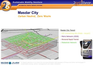
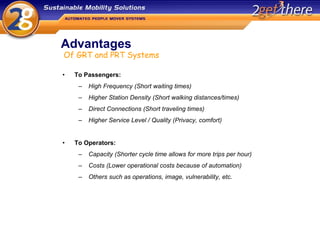
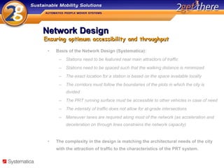
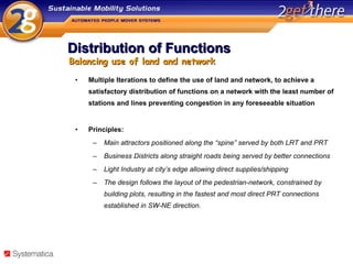
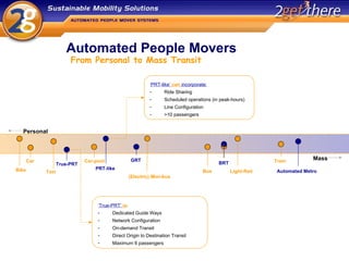
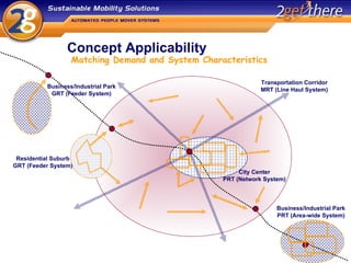
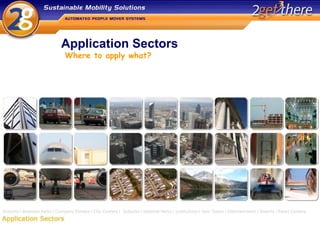
Towards Sustainable Transportation
The Future is NOW! Unknown doesn’t mean it doesn’t exist
Personal Rapid Transit Personal Rapdi Transit (PRT) a transport method that offers personal, on-demand non-stop transportation between any two points on a network of specially built guide-ways. Basically: automated taxi service True PRT vs. PRT like systems Ride Sharing during peak hours makes sense (?) to decrease the fleet size required and the capital costs associated with projects To what degree is a separate infrastructure required? In existing build up areas there is not much space available and elevated systems are often met with objections of visual intrusion? Automated Taxi Service
Introducing PRT Carbon Neutral = Zero Cars Masdar City will feature public transit with a private character (PRT) alongside light-rail, metro and other environmentally friendly means of transit (e.g. Segway). Mobility and accessibility are ensured, but not at the expense of space and living comfort. Urban Planning A dedicated, grade separated guide way ensures system throughput, safety and availability of space at grade for other purposes. An ‘undercroft’ (with a raised pedestrian level) was selected over an elevated or underground infrastructure, as a result of the thickness of the network, the (visual) impact  on the fabric of the city and the improvement of energy efficiency with the system sheltered from the elements. To the Sustainable City
Masdar City  Carbon Neutral, Zero Waste
Advantages To Passengers: High Frequency (Short waiting times) Higher Station Density (Short walking distances/times) Direct Connections (Short traveling times) Higher Service Level / Quality (Privacy, comfort)  To Operators: Capacity (Shorter cycle time allows for more trips per hour) Costs (Lower operational costs because of automation) Others such as operations, image, vulnerability, etc.  Of GRT and PRT Systems
Network Design Basis of the Network Design (Systematica): Stations need to be featured near main attractors of traffic Stations need to be spaced such that the walking distance is minimized The exact location for a station is based on the space available locally The corridors must follow the boundaries of the plots in which the city is divided The PRT running surface must be accessible to other vehicles in case of need The intensity of traffic does not allow for at-grade intersections Maneuver lanes are required along most of the network (as acceleration and deceleration on through lines constrains the network capacity) The complexity in the design is matching the architectural needs of the city with the attraction of traffic to the characteristics of the PRT system. Ensuring optimum accessibility and throughput
Distribution of Functions Multiple Iterations to define the use of land and network, to achieve a satisfactory distribution of functions on a network with the least number of stations and lines preventing congestion in any foreseeable situation Principles: Main attractors positioned along the “spine” served by both LRT and PRT Business Districts along straight roads being served by better connections Light Industry at city’s edge allowing direct supplies/shipping  The design follows the layout of the pedestrian-network, constrained by building plots, resulting in the fastest and most direct PRT connections established in SW-NE direction.  Balancing use of land and network
How Automated are we already? Technology History
Automated People Movers From Personal to Mass Transit Personal Mass True-PRT PRT-like GRT BRT Automated Metro Bike Car Taxi Car-pool Train (Electric) Mini-bus Bus Light-Rail ‘ True-PRT’  is : Dedicated Guide Ways  Network Configuration On-demand Transit Direct Origin to Destination Transit Maximum 6 passengers ‘ PRT-like’  can  incorporate: Ride Sharing Scheduled operations (in peak-hours)  Line Configuration >10 passengers
Concept Applicability Function  Local Area Transit / Feeder System / Corridor Transportation System  Intensity of transportation  Required capacity / Minimum headways possible / Station capacity & lay-out Spreading in time  Transportation Request Pattern Spreading in Space 5. Spatial planning  Spatial limitations in construction of the track and stations Customer requirements / preferences Application environment characteristics Noise and air pollution regulations / Visual Intrusion Application Specific Issues 3 rd  Party Interests / Political Influences Costs Factors to determine (the most) suitable system(s)
Concept Applicability Matching Demand and System Characteristics Business/Industrial Park PRT (Area-wide System) Business/Industrial Park GRT (Feeder System) Transportation Corridor MRT (Line Haul System) Residential Suburb GRT (Feeder System) City Center PRT (Network System)
Application Sectors Where to apply what?
Outlook Systems that combines the characteristics and the service of the car with the qualities of public transit, have the potential to alter the way cities (and private developments like e.g. airports) are planned, designed and build. Despite its small footprint, integration in the spatial planning and finding a balance between architectural design and system optimization are key for both greenfield and brownfield applications. The technology is here, studies are performed; which customer has the ‘guts’ to make a decision and move forward with PRT? From the perspective of sustainability and costs: will PRT in its most pure form ever be realized? Ride sharing during peak hours makes sense! PRT and the Sustainable City

Ilmastotalkoot: Robbert Lohmann

  • 1.
  • 2.
    The Future isNOW! Unknown doesn’t mean it doesn’t exist
  • 3.
    Personal Rapid TransitPersonal Rapdi Transit (PRT) a transport method that offers personal, on-demand non-stop transportation between any two points on a network of specially built guide-ways. Basically: automated taxi service True PRT vs. PRT like systems Ride Sharing during peak hours makes sense (?) to decrease the fleet size required and the capital costs associated with projects To what degree is a separate infrastructure required? In existing build up areas there is not much space available and elevated systems are often met with objections of visual intrusion? Automated Taxi Service
  • 4.
    Introducing PRT CarbonNeutral = Zero Cars Masdar City will feature public transit with a private character (PRT) alongside light-rail, metro and other environmentally friendly means of transit (e.g. Segway). Mobility and accessibility are ensured, but not at the expense of space and living comfort. Urban Planning A dedicated, grade separated guide way ensures system throughput, safety and availability of space at grade for other purposes. An ‘undercroft’ (with a raised pedestrian level) was selected over an elevated or underground infrastructure, as a result of the thickness of the network, the (visual) impact on the fabric of the city and the improvement of energy efficiency with the system sheltered from the elements. To the Sustainable City
  • 5.
    Masdar City Carbon Neutral, Zero Waste
  • 6.
    Advantages To Passengers:High Frequency (Short waiting times) Higher Station Density (Short walking distances/times) Direct Connections (Short traveling times) Higher Service Level / Quality (Privacy, comfort) To Operators: Capacity (Shorter cycle time allows for more trips per hour) Costs (Lower operational costs because of automation) Others such as operations, image, vulnerability, etc. Of GRT and PRT Systems
  • 7.
    Network Design Basisof the Network Design (Systematica): Stations need to be featured near main attractors of traffic Stations need to be spaced such that the walking distance is minimized The exact location for a station is based on the space available locally The corridors must follow the boundaries of the plots in which the city is divided The PRT running surface must be accessible to other vehicles in case of need The intensity of traffic does not allow for at-grade intersections Maneuver lanes are required along most of the network (as acceleration and deceleration on through lines constrains the network capacity) The complexity in the design is matching the architectural needs of the city with the attraction of traffic to the characteristics of the PRT system. Ensuring optimum accessibility and throughput
  • 8.
    Distribution of FunctionsMultiple Iterations to define the use of land and network, to achieve a satisfactory distribution of functions on a network with the least number of stations and lines preventing congestion in any foreseeable situation Principles: Main attractors positioned along the “spine” served by both LRT and PRT Business Districts along straight roads being served by better connections Light Industry at city’s edge allowing direct supplies/shipping The design follows the layout of the pedestrian-network, constrained by building plots, resulting in the fastest and most direct PRT connections established in SW-NE direction. Balancing use of land and network
  • 9.
    How Automated arewe already? Technology History
  • 10.
    Automated People MoversFrom Personal to Mass Transit Personal Mass True-PRT PRT-like GRT BRT Automated Metro Bike Car Taxi Car-pool Train (Electric) Mini-bus Bus Light-Rail ‘ True-PRT’ is : Dedicated Guide Ways Network Configuration On-demand Transit Direct Origin to Destination Transit Maximum 6 passengers ‘ PRT-like’ can incorporate: Ride Sharing Scheduled operations (in peak-hours) Line Configuration >10 passengers
  • 11.
    Concept Applicability Function Local Area Transit / Feeder System / Corridor Transportation System Intensity of transportation Required capacity / Minimum headways possible / Station capacity & lay-out Spreading in time Transportation Request Pattern Spreading in Space 5. Spatial planning Spatial limitations in construction of the track and stations Customer requirements / preferences Application environment characteristics Noise and air pollution regulations / Visual Intrusion Application Specific Issues 3 rd Party Interests / Political Influences Costs Factors to determine (the most) suitable system(s)
  • 12.
    Concept Applicability MatchingDemand and System Characteristics Business/Industrial Park PRT (Area-wide System) Business/Industrial Park GRT (Feeder System) Transportation Corridor MRT (Line Haul System) Residential Suburb GRT (Feeder System) City Center PRT (Network System)
  • 13.
  • 14.
    Outlook Systems thatcombines the characteristics and the service of the car with the qualities of public transit, have the potential to alter the way cities (and private developments like e.g. airports) are planned, designed and build. Despite its small footprint, integration in the spatial planning and finding a balance between architectural design and system optimization are key for both greenfield and brownfield applications. The technology is here, studies are performed; which customer has the ‘guts’ to make a decision and move forward with PRT? From the perspective of sustainability and costs: will PRT in its most pure form ever be realized? Ride sharing during peak hours makes sense! PRT and the Sustainable City