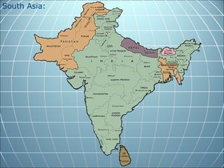
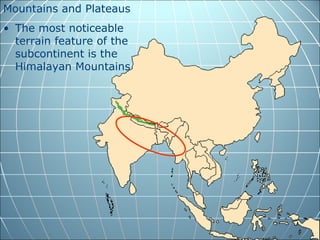
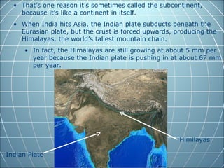
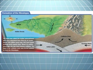
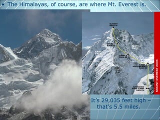
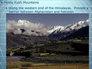
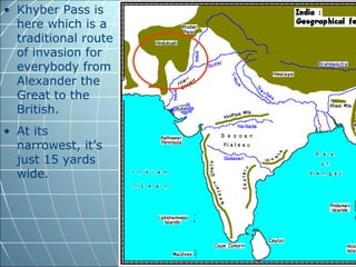
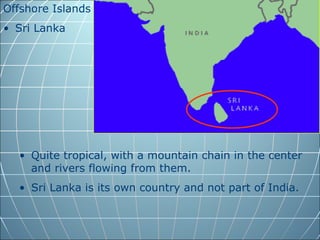
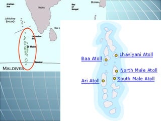
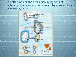
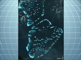
South Asia:
Landforms and Resources

     Indian Awesomeness
South Asia:
Mountains and Plateaus
• The most noticeable
  terrain feature of the
  subcontinent is the
  Himalayan Mountains.
• That’s one reason it’s sometimes called the subcontinent,
    because it’s like a continent in itself.
  • When India hits Asia, the Indian plate subducts beneath the
    Eurasian plate, but the crust is forced upwards, producing the
    Himalayas, the world’s tallest mountain chain.
     • In fact, the Himalayas are still growing at about 5 mm per
       year because the Indian plate is pushing in at about 67 mm
       per year.


                                                      Himilayas

Indian Plate
• The Himalayas, of course, are where Mt. Everest is.


                                It’s 29,035 feet high –
                                   that’s 5.5 miles.
• Hindu Kush Mountains
  • Along the western end of the Himalayas. Provide a
    barrier between Afghanistan and Pakistan.
Former Taliban and
Osama bin Laden used
the Hindu Kush
mountains as hiding
places.
• Khyber Pass is
  here which is a
  traditional route
  of invasion for
  everybody from
  Alexander the
  Great to the
  British.
• At its
  narrowest, it’s
  just 15 yards
  wide.
Khyber Pass, looking from Afghanistan to Pakistan
• The rivers carry a great deal of alluvial soil (silt) that
  gets deposited on the alluvial plains and makes for an
  exceptionally fertile area.
   • These plains support a massive population. Most of
     India’s 1 billion people live around here.
Population Density
United States
 281,422,000 people          1,002,142,000 people
 3,787,319 square miles      1,195,063 square miles

   74.3 ppl/ sq mile         839 ppl/ sq mile
Offshore Islands
• Sri Lanka


  • Quite tropical, with a mountain chain in the center
    and rivers flowing from them.
  • Sri Lanka is its own country and not part of India.
• The Maldives
  • A collection of 1,200 islands that make up an
    archipelago (a collection of islands).
  • The islands are actually the tops of volcanoes
    surrounded by coral to make up smaller atolls.
  • They’re short too. The highest point of the island
    country is 7.5 feet above sea level.
  • The total land area is only 115 square miles, but has
    400 miles of coastline.
  • Of the 1,200 islands, only about 200 are inhabited.
• A better look at the atolls (low-lying tops of
  submerged volcanoes, surrounded by coral reefs and
  shallow lagoons).
Natural Resources
• There’s a lot that’s dependent on water and soil.
  • Those rivers and their soil provide for a lot of
    irrigation and rich farmland.
  • That makes for a lot of agriculture as well as river-
    based products like fish in addition to sea fishing.
  • The navigable rivers and the coastlines are good for
    transportation.
• Forests
  • The timber industry is big.
  • Rain forests produce teak, bamboo, and
    sandalwood.
  • Highland forests produce pine, fir, and others.
  • Deforestation is a big problem, however.
• Minerals
  • Coal, iron, uranium, diamonds, rubies, sapphires.
Chapter 24, sec. 1 questions

1. Name the largest country in South Asia.
2. What is a subcontinent?
3. How many people live in India?
4. Name the mountain range that serves as the
   border between the Indian subcontinent and
   China.
5. Name the mountains that lie at the west end of
   the Himalayas.
6. What is an archipelago?
7. What is an atoll?

24.1 south asia-landforms and resources

  • 1.
    South Asia: Landforms andResources Indian Awesomeness
  • 2.
  • 3.
    Mountains and Plateaus •The most noticeable terrain feature of the subcontinent is the Himalayan Mountains.
  • 4.
    • That’s onereason it’s sometimes called the subcontinent, because it’s like a continent in itself. • When India hits Asia, the Indian plate subducts beneath the Eurasian plate, but the crust is forced upwards, producing the Himalayas, the world’s tallest mountain chain. • In fact, the Himalayas are still growing at about 5 mm per year because the Indian plate is pushing in at about 67 mm per year. Himilayas Indian Plate
  • 7.
    • The Himalayas,of course, are where Mt. Everest is. It’s 29,035 feet high – that’s 5.5 miles.
  • 9.
    • Hindu KushMountains • Along the western end of the Himalayas. Provide a barrier between Afghanistan and Pakistan.
  • 10.
    Former Taliban and Osamabin Laden used the Hindu Kush mountains as hiding places.
  • 11.
    • Khyber Passis here which is a traditional route of invasion for everybody from Alexander the Great to the British. • At its narrowest, it’s just 15 yards wide.
  • 12.
    Khyber Pass, lookingfrom Afghanistan to Pakistan
  • 13.
    • The riverscarry a great deal of alluvial soil (silt) that gets deposited on the alluvial plains and makes for an exceptionally fertile area. • These plains support a massive population. Most of India’s 1 billion people live around here.
  • 14.
    Population Density United States 281,422,000 people  1,002,142,000 people  3,787,319 square miles  1,195,063 square miles  74.3 ppl/ sq mile  839 ppl/ sq mile
  • 15.
    Offshore Islands • SriLanka • Quite tropical, with a mountain chain in the center and rivers flowing from them. • Sri Lanka is its own country and not part of India.
  • 17.
    • The Maldives • A collection of 1,200 islands that make up an archipelago (a collection of islands). • The islands are actually the tops of volcanoes surrounded by coral to make up smaller atolls. • They’re short too. The highest point of the island country is 7.5 feet above sea level. • The total land area is only 115 square miles, but has 400 miles of coastline. • Of the 1,200 islands, only about 200 are inhabited.
  • 19.
    • A betterlook at the atolls (low-lying tops of submerged volcanoes, surrounded by coral reefs and shallow lagoons).
  • 23.
    Natural Resources • There’sa lot that’s dependent on water and soil. • Those rivers and their soil provide for a lot of irrigation and rich farmland. • That makes for a lot of agriculture as well as river- based products like fish in addition to sea fishing. • The navigable rivers and the coastlines are good for transportation.
  • 24.
    • Forests • The timber industry is big. • Rain forests produce teak, bamboo, and sandalwood. • Highland forests produce pine, fir, and others. • Deforestation is a big problem, however.
  • 25.
    • Minerals • Coal, iron, uranium, diamonds, rubies, sapphires.
  • 26.
    Chapter 24, sec.1 questions 1. Name the largest country in South Asia. 2. What is a subcontinent? 3. How many people live in India? 4. Name the mountain range that serves as the border between the Indian subcontinent and China. 5. Name the mountains that lie at the west end of the Himalayas. 6. What is an archipelago? 7. What is an atoll?