Downloaded 49 times


![“ him” [snow] “ aalaya” [home] Mt. Everest is 29,035 feet. It is the highest mt. peak in the world. The Himalayas](https://image.slidesharecdn.com/sageography-091002130315-phpapp01-111104103257-phpapp01/85/Sageography-091002130315-phpapp01-9-320.jpg)


![The Deccan Plateau 31,800 square miles in size. Elevation range: 2,000 – 8,000 feet high. From the Sanskrit word, “dakshina” [“the south”].](https://image.slidesharecdn.com/sageography-091002130315-phpapp01-111104103257-phpapp01/85/Sageography-091002130315-phpapp01-14-320.jpg)


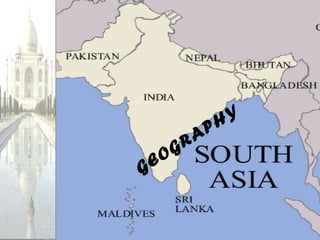
South Asia consists of 7 countries located on the Indian subcontinent, which is a large landmass that rests on its own tectonic plate. The region has diverse landforms including mountains, rivers, deserts, and plateaus. The northern border is defined by three mountain systems - the Hindu Kush, Himalaya, and Karakoram ranges. The Himalayas are the highest mountains in the world and have kept South Asia isolated. South of the mountains are wide fertile plains watered by major rivers like the Indus, Ganges, and Brahmaputra. The southern region contains mountain chains and plateaus like the Deccan Plateau, as well as deserts like the Thar.


![[Slideshare-Downloader-la]-649a802f32a57.pptx](https://cdn.slidesharecdn.com/ss_thumbnails/slideshare-downloader-la-649a802f32a57-230714063120-43bfbf18-thumbnail.jpg?width=640&height=640&fit=bounds)


