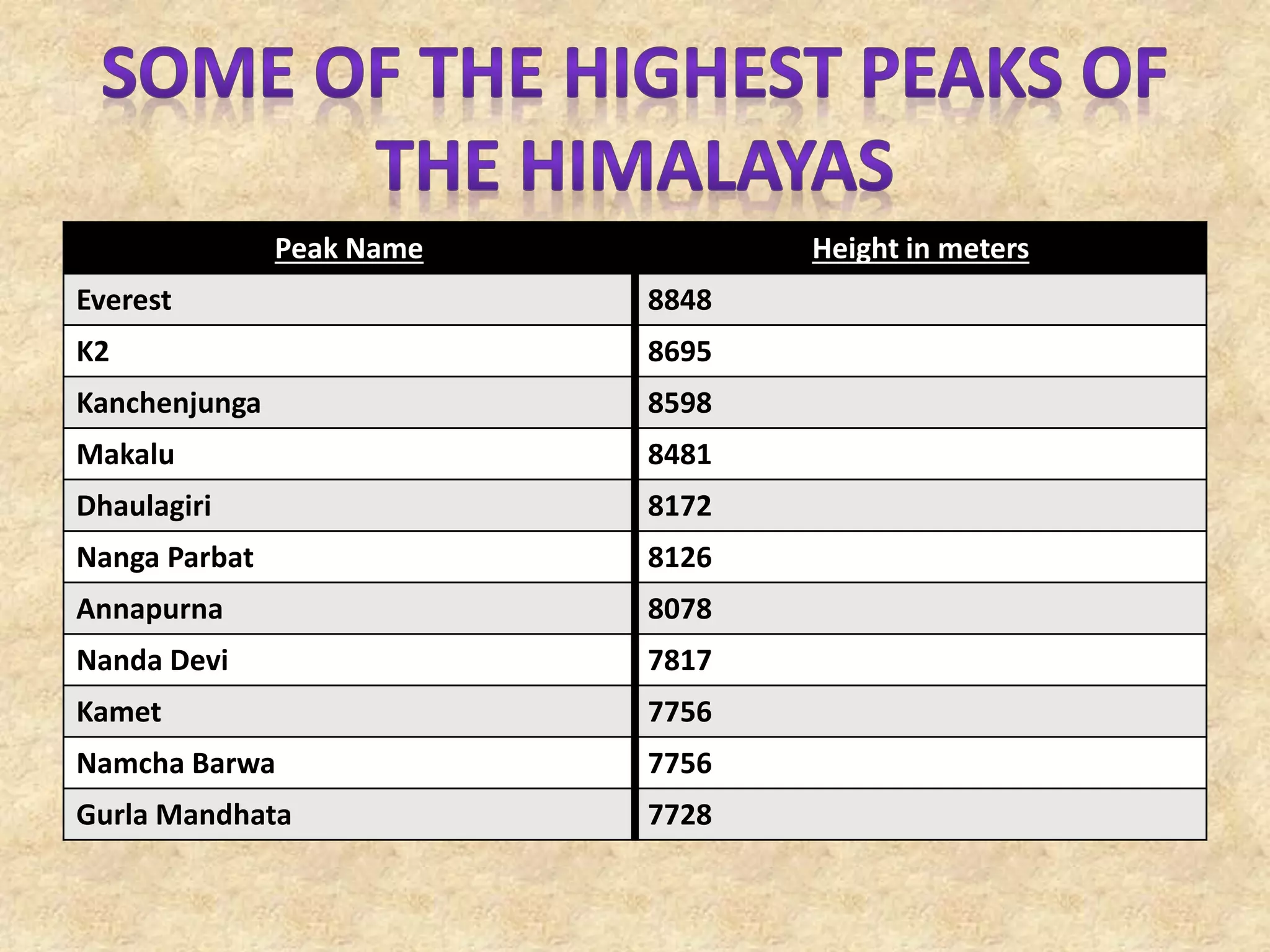
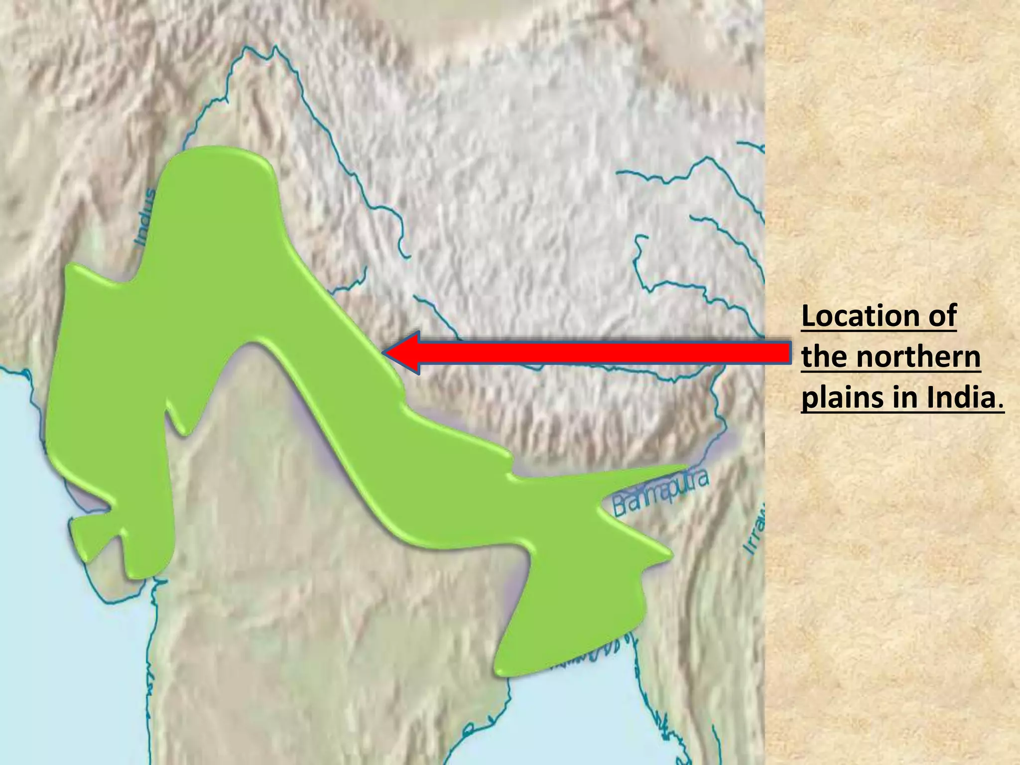
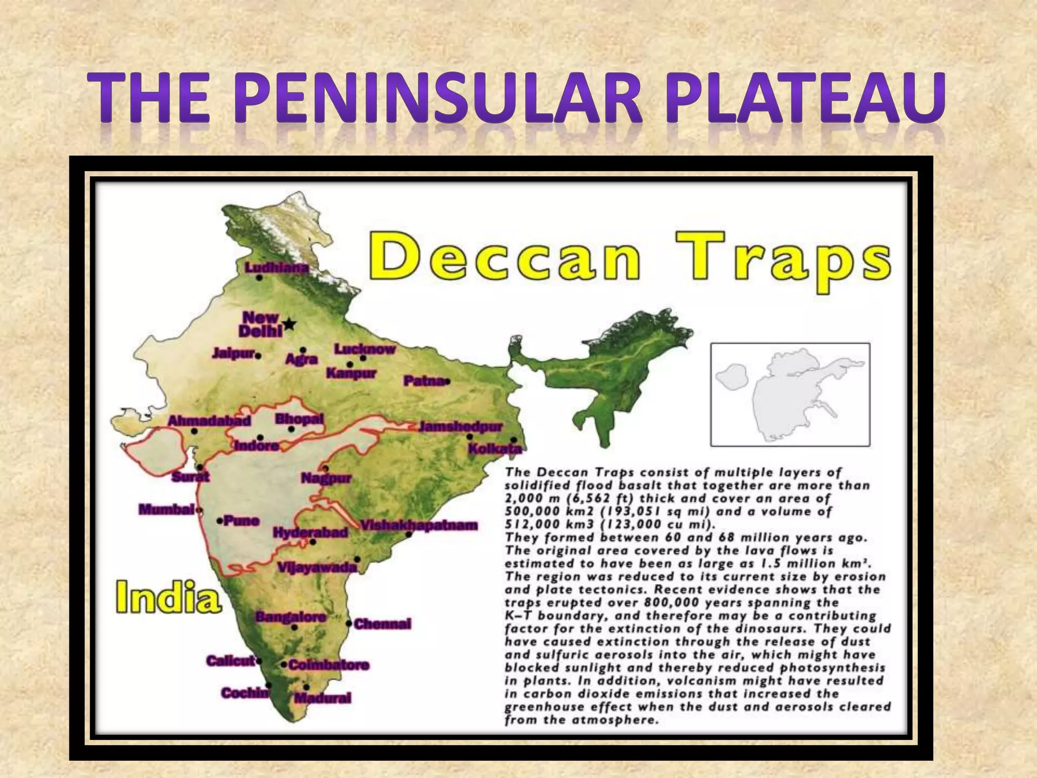
India is a vast country with varied landforms.
Our country has practically all major physical
features of the Earth i.e. Mountains, Plains,
Deserts, Plateaus and Islands. India is a large
landmass formed during different geological
periods which has influenced her relief its
present form. The movement of the plates
results in building up of stresses within the
plates and the continental rocks above,
leading to folding, faulting and volcanic
activity.
• Plate movements are classified into three types.
• They are; Convergent Boundary While some plates
come towards each other and form convergent
boundary.
• Divergent Boundary some plates move away from
each other and form divergent boundary.
• Transform Boundary In the event of two plates
coming together they may either collide and
crumble, or one may slide under the other. At
times, they may also move horizontally past each
other and form transform boundary.
• The oldest landmass, (the Peninsula part), was a part of the
Gondwana land.
• The Gondwana land included India, Australia, South Africa
and South America as one single land mass.
• The convectional currents split the crust into a number of
pieces, thus leading to the drifting of the Indo-Australian
plate after being separated from the Gondwana land,
towards north.
• The northward drift resulted in the collision of the plate
with the much larger Eurasian Plate.
• Due to this collision, the sedimentary rocks which were
accumulated in the geosyncline known as the Tethys were
folded to form the mountain system of western Asia and
Himalaya.
• The Himalayan Mountains
• The Northern Plains
• The Peninsular Plateau
• The Indian Desert
• The Coastal Plains
• The Islands
• The Himalayas are geologically young and
structurally fold mountains which stretch
over the northern borders of India.
• These mountain ranges run in a west–east
direction from Indus to Brahmaputra.
• Himalayas covers a distance of about
2400km. Their width varies from 400km in
Kashmir to 150km in Arunachal Pradesh.
The Himalaya consist of three parallel ranges in its
longitudinal extent.
 The northern most range is known as the inner Himalayas
or the Himadri . It is most continuous range consisting of
the loftiest peaks with an average height of 6000m . It
consist of all prominent Himalayan peaks.
 The range lying to the south of Himadri forms the most
rugged mountain system and is also known as Himachal or
lesser Himalaya . The altitude varies between 3700 and
4500m and the average width is of 50 km . This range is
famous for hill station like Kangra and Kullu valley.
 The outer most range of the Himalayas is called the
Shiwaliks . They extend over a width of 10-50km and have
an altitude varying between 900 – 1100m . This range is
famous for duns like dehra dun kotli dun etc .
• The Himalaya has been divided on the basis of regions from
west to east .
• The part of Himalaya lying between Indus and satluj has been
traditionally known as Punjab Himalayas .
• The part of Himalayas lying between satluj and kali rivers is
known as kumoun Himalayas . The kali and the tista rivers
demarcate the Nepal Himalayas .
• And the Himalayas lying between tista and dihang rivers is
known as Assam Himalayas . The Himalayas which spread
along the eastern boarders of India is known as purvachal .
Peak Name Height in meters
Everest 8848
K2 8695
Kanchenjunga 8598
Makalu 8481
Dhaulagiri 8172
Nanga Parbat 8126
Annapurna 8078
Nanda Devi 7817
Kamet 7756
Namcha Barwa 7756
Gurla Mandhata 7728
• The northern plain has been formed by the interplay of three major
river systems ; the Indus, the Brahmaputra,the Ganga along with
their tributaries.
• This plain is formed of alluvial soil .The deposition of alluvium in a
vast basin lying at the foothills of the Himalaya over millions of years,
formed this fertile plain.
• It spreads over an area of 7 lakh sq.km . The plain being about
2400km long and 240 to 320 km broad, is a densely populated
physiographic division.
• With a rich soil cover combined with adequate water supply and
favorable climate it is agriculturally a very productive part of India.
Location of
the northern
plains in India.
• The peninsular plateau is a table land composed
of the old crystalline, igneous and metamorphic
rocks.
• It was formed due to the breaking and drifting
of Gondwana land and thus making it a part of
the oldest landmass.
• This plateau consist of 2 broad divisions:
The Central Highlands
The Deccan Plateau
• The part of the peninsular plateau lying to the
north of Narmada river covering a major area of
Malwa plateau is known as Central highlands.
• The Deccan plateau is a triangular landmass
lying to the south of river Narmada . The
Satpura range flanks its broad base in the north
while the Mahadev, the Kaimur hills and the
Maikal range form its eastern extensions.
• Western Ghats lie parallel to the western coast .
They are continues and can be crossed through
passes only.
• The Western Ghats are higher than the Eastern
Ghats . Their average elevation is 900 to 1600m.
• The western Ghats cause orographic rain by
facing the rain bearing moist winds to rise along
the western slopes of then Ghats.
• The western Ghats are known by different local
names . The highest peaks include Anai mudi
and the Doda betta.
• Eastern Ghats are lower than Western Ghats
elevation of Ghats. The average Eastern
Ghats is 600m.
• The Eastern Ghats stretch from the
Mahanadi Valley to the Nigiris in the south.
The Eastern Ghats are discontinuous and
irregular and dissected by river draining into
the Bay of Bengal. Mahindragiri is the highest
peak in the Eastern Ghats.
• The Indian deserts The Indian Deserts lies towards
the western margins of the Aravali hills .
• It is an undulating sandy plain covered with sandunes
this region receives very low rainfall below 150 mm
per year .
• It has arid climate with low vegetation cover .
Streams appear during the rainy season . Soon after
they disappear into the sand as they do not have
enough water to reach the sea .
• Luni is the only large river in this region . Barchans
cover larger areas but longitudinal dunes become
more prominent near the indo – Pakistan boundary .
• The coastal plains the Peninsular plateau is flanked by stretch of
narrow coastal strips , running along the Arabian sea on the west
and the Bay of Bengal on the east.
• The Western coast, sandwiched between the western Ghats and
the Arabian sea is a narrow plain . It consist of three sections.
• The northern part of the coast is called the Konkan , the central
stretch is called the Kannad plain while southern is referred to as
the Malabar coast the plains along the bay of Bengal are wide and
level in the northern part , it is referred to as the northern Circar ,
while the southern part is known as Koramandal coast.
• Large rivers such as the Mahanadi , the Godavari , the Krishna and
the Kaveri have former extensive delta on this coast.
• Lake Chilka is an important feature along the eastern coast
• Besides a vast main land , India has also 2
groups of islands.
• The Lakshadweep islands close to the Malabar
coast of Kerala is composed of small coral
islands. It covers small area of 32 sq.Km and
Kavarathi island is the administrative head
quarters.
• This island group has great diversity of flora and
fauna the pity island , which is uninhabited, has
a bird sanctuary .
• Andaman and Nicobar The Andaman and
Nicobar islands is located in the bay of Bengal
they are bigger in size and are more numerous
and scattered.
• The entire group of islands is divided into 2
broad categories the Andaman in the north and
the Nicobar in the south.
• These islands lie close to equator and
experience equatorial climate and has thick
forest cover .
Physical features of india

Physical features of india

  • 3.
    India is avast country with varied landforms. Our country has practically all major physical features of the Earth i.e. Mountains, Plains, Deserts, Plateaus and Islands. India is a large landmass formed during different geological periods which has influenced her relief its present form. The movement of the plates results in building up of stresses within the plates and the continental rocks above, leading to folding, faulting and volcanic activity.
  • 4.
    • Plate movementsare classified into three types. • They are; Convergent Boundary While some plates come towards each other and form convergent boundary. • Divergent Boundary some plates move away from each other and form divergent boundary. • Transform Boundary In the event of two plates coming together they may either collide and crumble, or one may slide under the other. At times, they may also move horizontally past each other and form transform boundary.
  • 6.
    • The oldestlandmass, (the Peninsula part), was a part of the Gondwana land. • The Gondwana land included India, Australia, South Africa and South America as one single land mass. • The convectional currents split the crust into a number of pieces, thus leading to the drifting of the Indo-Australian plate after being separated from the Gondwana land, towards north. • The northward drift resulted in the collision of the plate with the much larger Eurasian Plate. • Due to this collision, the sedimentary rocks which were accumulated in the geosyncline known as the Tethys were folded to form the mountain system of western Asia and Himalaya.
  • 8.
    • The HimalayanMountains • The Northern Plains • The Peninsular Plateau • The Indian Desert • The Coastal Plains • The Islands
  • 10.
    • The Himalayasare geologically young and structurally fold mountains which stretch over the northern borders of India. • These mountain ranges run in a west–east direction from Indus to Brahmaputra. • Himalayas covers a distance of about 2400km. Their width varies from 400km in Kashmir to 150km in Arunachal Pradesh.
  • 11.
    The Himalaya consistof three parallel ranges in its longitudinal extent.  The northern most range is known as the inner Himalayas or the Himadri . It is most continuous range consisting of the loftiest peaks with an average height of 6000m . It consist of all prominent Himalayan peaks.  The range lying to the south of Himadri forms the most rugged mountain system and is also known as Himachal or lesser Himalaya . The altitude varies between 3700 and 4500m and the average width is of 50 km . This range is famous for hill station like Kangra and Kullu valley.  The outer most range of the Himalayas is called the Shiwaliks . They extend over a width of 10-50km and have an altitude varying between 900 – 1100m . This range is famous for duns like dehra dun kotli dun etc .
  • 12.
    • The Himalayahas been divided on the basis of regions from west to east . • The part of Himalaya lying between Indus and satluj has been traditionally known as Punjab Himalayas . • The part of Himalayas lying between satluj and kali rivers is known as kumoun Himalayas . The kali and the tista rivers demarcate the Nepal Himalayas . • And the Himalayas lying between tista and dihang rivers is known as Assam Himalayas . The Himalayas which spread along the eastern boarders of India is known as purvachal .
  • 13.
    Peak Name Heightin meters Everest 8848 K2 8695 Kanchenjunga 8598 Makalu 8481 Dhaulagiri 8172 Nanga Parbat 8126 Annapurna 8078 Nanda Devi 7817 Kamet 7756 Namcha Barwa 7756 Gurla Mandhata 7728
  • 15.
    • The northernplain has been formed by the interplay of three major river systems ; the Indus, the Brahmaputra,the Ganga along with their tributaries. • This plain is formed of alluvial soil .The deposition of alluvium in a vast basin lying at the foothills of the Himalaya over millions of years, formed this fertile plain. • It spreads over an area of 7 lakh sq.km . The plain being about 2400km long and 240 to 320 km broad, is a densely populated physiographic division. • With a rich soil cover combined with adequate water supply and favorable climate it is agriculturally a very productive part of India.
  • 16.
  • 18.
    • The peninsularplateau is a table land composed of the old crystalline, igneous and metamorphic rocks. • It was formed due to the breaking and drifting of Gondwana land and thus making it a part of the oldest landmass. • This plateau consist of 2 broad divisions: The Central Highlands The Deccan Plateau
  • 19.
    • The partof the peninsular plateau lying to the north of Narmada river covering a major area of Malwa plateau is known as Central highlands. • The Deccan plateau is a triangular landmass lying to the south of river Narmada . The Satpura range flanks its broad base in the north while the Mahadev, the Kaimur hills and the Maikal range form its eastern extensions.
  • 20.
    • Western Ghatslie parallel to the western coast . They are continues and can be crossed through passes only. • The Western Ghats are higher than the Eastern Ghats . Their average elevation is 900 to 1600m. • The western Ghats cause orographic rain by facing the rain bearing moist winds to rise along the western slopes of then Ghats. • The western Ghats are known by different local names . The highest peaks include Anai mudi and the Doda betta.
  • 21.
    • Eastern Ghatsare lower than Western Ghats elevation of Ghats. The average Eastern Ghats is 600m. • The Eastern Ghats stretch from the Mahanadi Valley to the Nigiris in the south. The Eastern Ghats are discontinuous and irregular and dissected by river draining into the Bay of Bengal. Mahindragiri is the highest peak in the Eastern Ghats.
  • 23.
    • The Indiandeserts The Indian Deserts lies towards the western margins of the Aravali hills . • It is an undulating sandy plain covered with sandunes this region receives very low rainfall below 150 mm per year . • It has arid climate with low vegetation cover . Streams appear during the rainy season . Soon after they disappear into the sand as they do not have enough water to reach the sea . • Luni is the only large river in this region . Barchans cover larger areas but longitudinal dunes become more prominent near the indo – Pakistan boundary .
  • 25.
    • The coastalplains the Peninsular plateau is flanked by stretch of narrow coastal strips , running along the Arabian sea on the west and the Bay of Bengal on the east. • The Western coast, sandwiched between the western Ghats and the Arabian sea is a narrow plain . It consist of three sections. • The northern part of the coast is called the Konkan , the central stretch is called the Kannad plain while southern is referred to as the Malabar coast the plains along the bay of Bengal are wide and level in the northern part , it is referred to as the northern Circar , while the southern part is known as Koramandal coast. • Large rivers such as the Mahanadi , the Godavari , the Krishna and the Kaveri have former extensive delta on this coast. • Lake Chilka is an important feature along the eastern coast
  • 27.
    • Besides avast main land , India has also 2 groups of islands. • The Lakshadweep islands close to the Malabar coast of Kerala is composed of small coral islands. It covers small area of 32 sq.Km and Kavarathi island is the administrative head quarters. • This island group has great diversity of flora and fauna the pity island , which is uninhabited, has a bird sanctuary .
  • 28.
    • Andaman andNicobar The Andaman and Nicobar islands is located in the bay of Bengal they are bigger in size and are more numerous and scattered. • The entire group of islands is divided into 2 broad categories the Andaman in the north and the Nicobar in the south. • These islands lie close to equator and experience equatorial climate and has thick forest cover .