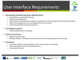
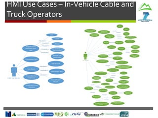
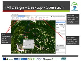
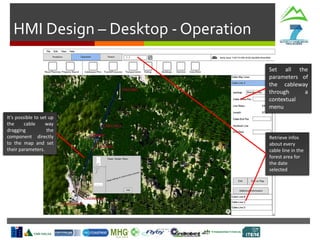
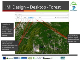
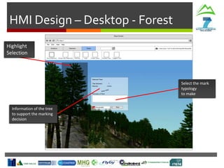
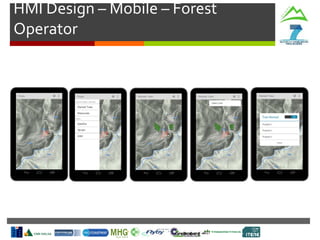
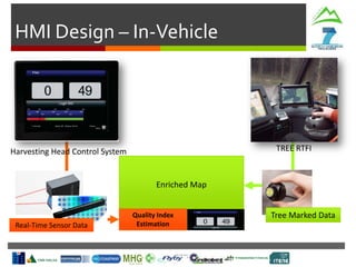
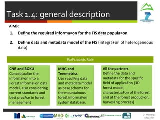
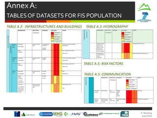
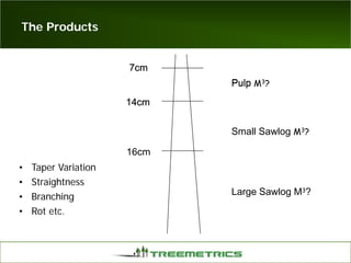
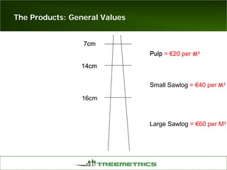
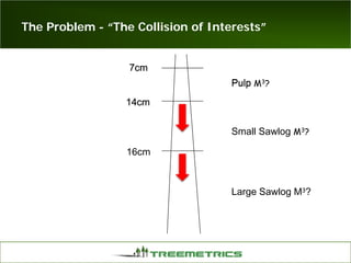
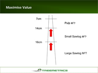
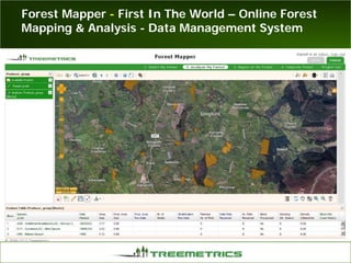
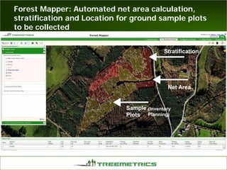
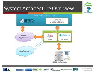
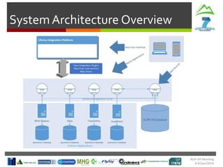
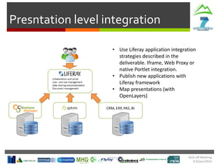
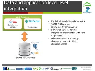
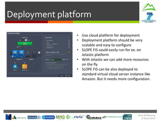
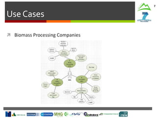
- Weather
- Production Targets
- Contingency Plans
Harvesting Head
Control Interface
Production
Statistics
Machine
Parameters
Tree Detection
& Recognition
SLOPE
In-Vehicle
Interface
Machine
Monitoring
Route
Planning
Cable Crane
Control
Risks and Mitigation Actions
Technical Meeting
2-4/Jul/2014
Risks:
- Integration with existing systems (MHG, TREE) not seamless
- Mobile/In-Vehicle interfaces not robust enough for field conditions
- User acceptance of new interfaces
Mitigation Actions:
- Early prototyping and testing with end users
- Modular design allowing independent development
The document discusses the development of a forest information system called Project SLOPE. It involves 5 work packages, including the development of a database to support novel inventory data (WP5.1), a platform for near real-time control of forest operations (WP5.2), and an online purchasing/invoicing system for industrial timber and biomass (WP5.3). It will also include the development of modules for short-term optimization (WP5.4) and mid-long term optimization/strategic planning (WP5.5). The system will integrate data on timber quality, quantities, and origin to optimize procedures and avoid delays. It will also facilitate long-term forest planning, simulations, optimization, and
The document provides an overview of activities for piloting the SLOPE demonstrator. It summarizes preparations for demonstrators in Sover, Italy in spring 2016 and Annaberg, Austria in autumn 2016. It describes the survey site in Annaberg including the characteristics of the forest stand and outlines activities already performed at the site. It then presents prospective plans for the harvesting demo in Annaberg, including marking trees with RFIDs, felling, extracting and processing trees. An agreement with Austrian Federal Forests to support the demo is also summarized.
The document summarizes the work completed for Task 1.3 of defining the human-machine interfaces for the SLOPE system. It describes the process undertaken which included analyzing existing interfaces from consortium partners and defining requirements based on user needs. Interface designs were then created for desktop, mobile, in-vehicle, and ERP systems with the desktop interface having tools for analytics, operations, and forest management. The interfaces were designed based on usability principles and to integrate with existing partner systems.
This document discusses Project SLOPE's Work Package 7, which focuses on piloting the SLOPE demonstrator. Task 7.1 involves defining an evaluation methodology for testing two forest supply chains. Task 7.2 prepares demonstrators by developing experimental designs and guidelines. Task 7.3 conducts trials and validation, evaluating data collection methods, processes, and the overall performance of the supply chains. Task 7.4 provides training to operators. The goals are to demonstrate models, systems, stakeholder involvement and on-the-job training. Partners will trial and validate the framework in Austria, Italy and Norway between 2014-2016.
Project SLOPE is developing a forest information system to optimize timber harvesting and supply chain operations. The system will integrate real-time data on tree sizes, product distributions, and harvesting machine positions. It aims to develop modules for inventory data, real-time supply chain control, online purchasing and invoicing, and short and long-term optimization. Partners will utilize existing solutions like MHG Biomass Manager and develop new applications to track harvesting data, manage transportation logistics, and facilitate online commerce between producers and buyers. The system seeks to strengthen industry linkages and competitiveness through information sharing.
The document describes Project SLOPE which aims to develop intelligent systems for tree marking, felling, hauling, and processing in mountain forests. It outlines the tasks, participants, goals, challenges, and timeline for Task 3.1 which focuses on developing an intelligent system for tree marking using RFID tags, GPS, and a rugged tablet computer to store and access forest inventory data and mark trees efficiently in mountainous terrain. The key challenges are ensuring the systems are ergonomic for mountain forest conditions and have high tag survival and reading rates to enable full traceability.
The document summarizes the status of Project SLOPE's Task 6.1 on system integration. It describes the development of an integrated forest management system through three main integration steps. The first step focuses on connecting forest inventory and harvesting software and hardware. It discusses the development of alpha versions 1.0 through 1.2 and plans to validate the initial integration and fill the system's database with real-time pilot data. Overall, the integration work is progressing well and establishing guidelines for efficient continuous integration of the various project components.
The document provides a mid-term review of work being done on Project SLOPE. It summarizes the status of tasks relating to developing an intelligent cable crane system. The TECNO self-propelled carriage has been completed mechanically and is stored, with only the electric box and wiring remaining. Work is ongoing to integrate sensors into the software over the next few months to develop deliverables due. Chokers and a synthetic rope launcher are also being developed as part of creating an intelligent cable harvesting system for steep terrain forest operations.
Slope Final Review Meeting - Introduction SLOPE Project
This document summarizes the agenda and objectives of a final review meeting for the SLOPE project. The SLOPE project aims to develop integrated processing and control systems to improve sustainability in mountain forest production. The meeting agenda covers reviewing progress on tasks in areas like requirements analysis, forest data collection, intelligent harvesting systems, quality control, and system integration. The objectives of the meeting are to evaluate fulfillment of deliverables, continued relevance of objectives, resource use, contributions of partners, and plans for impact and results dissemination. The review involves 10 partners across several European countries working for 36 months on developing and testing new forest monitoring and harvesting technologies.
This document summarizes a kick-off meeting for Project SLOPE. The project involves developing methods for remote sensing-based forest inventory and 3D modeling to evaluate harvesting technologies in mountain forests. Task 2.1 will design an automatic method for satellite-based forest inventory. Task 2.4 will generate a detailed 3D model of the forest to simulate harvesting plans and evaluate equipment. The model will integrate remote sensing, field measurements, and a web-based planning system to optimize harvesting in mountain areas.
The document outlines tasks related to defining requirements for Project SLOPE. Task 1.1 involves identifying user requirements through questionnaires. Task 1.2 defines hardware and equipment needs based on user requirements. Task 1.3 focuses on defining human-machine interfaces for different scenarios like planning, harvesting, and resource management. The tasks involve various partners contributing expertise in areas like 3D modeling, inventory, harvesting, and enterprise resource planning.
This work package aims to develop an automated grading system using multi-sensor data to improve log segregation and supply chain efficiency in mountain forests, including using near infrared spectroscopy, hyperspectral imaging, acoustic measurements, and cutting power analysis to estimate log quality and classify logs into quality classes.
WP 1 of the Project SLOPE was completed and focused on defining requirements for the system. It identified user needs through questionnaires, defined the necessary hardware, equipment and sensors, specified the user interface guidelines for desktop, mobile and in-vehicle access, developed a data and metadata model for storing forest information, and designed a scalable system architecture based on service-oriented principles. All deliverables were finalized and submitted on schedule, though some partners left the project early on. The work specified what was needed to develop the SLOPE Forest Information System.
The SLOPE project aims to optimize forest production through a 3D virtual forest system to support harvesting operations in mountainous areas. The system will integrate data from forest surveys, digital terrain and forest models, and real-time sensor data to create a digital model of the forest. This model will then support various harvesting planning and monitoring tasks, such as cableway deployment planning, working area setup, and tree felling monitoring. The system is being developed as a web-based application to allow easy access and integration with other services. It will track the entire process from tree tagging to sawmill processing.
This work package involves developing methods for quality control of mountain forest products using multi-sensor models. It has six subtasks: 1) using 3D modeling and sensors to develop a quality index for standing and felled trees, 2) evaluating near infrared spectroscopy to determine quality indexes, 3) using hyperspectral imaging to evaluate quality, 4) analyzing stress wave propagation to determine quality thresholds, 5) measuring cutting power to develop quality models, and 6) implementing the quality control system and algorithms.
The document discusses progress on Work Package 7 of the Project SLOPE, which involves piloting the SLOPE timber harvesting demonstrator. Key points discussed include:
- Potential harvesting sites have been identified in Austria and Italy for demonstrating the SLOPE system.
- Tasks include developing process flow charts, identifying bottlenecks, selecting evaluation methods, and planning demonstration activities from 2015-2018.
- Process/data flow charts will be created to visualize and compare the conventional and SLOPE timber supply chains. This will help identify strengths and risks of the new system.
The document summarizes work being done for Task 7.02 of the Project SLOPE, which involves preparing demonstrators to assess the technical and economic feasibility of the proposed SLOPE timber harvesting system compared to current methods. Activities being defined for the demonstrators include forest inventory, harvest planning, harvest operations, and logistics/storage/sale. Data will be collected from pilot studies on time consumption, productivity, costs, and other metrics to enable comparison between the innovative SLOPE methods and conventional approaches. Flow charts are provided as an example of how work cycles will be documented for analysis.
The document provides a mid-term review of Project SLOPE, which aims to develop innovative technologies for forestry operations in mountainous areas. It summarizes the status and results of Work Package 8 on dissemination and engagement activities over the first 18 months of the 36 month project. Key activities included developing dissemination strategies and materials, establishing a website and social media presence, organizing conferences and workshops, and initiating an Industrial Advisory Board with members from the forestry industry. The review indicates that dissemination goals have been achieved so far in raising awareness of the project and that focus should now turn to specific technical areas and maintaining engagement over the remainder of the project.
The Task 5.3 aims to design and develop an online purchasing and invoicing platform for industrial timber and biomass. Activities completed include benchmarking existing e-trading solutions in Finland and globally, and identifying key elements for the new platform such as material identification, negotiation, bidding, and market analysis functions. The platform will facilitate trade between forest owners and buyers in a digital environment.
The document summarizes work from Project SLOPE Task 2.1 on remote sensing and multispectral analysis of forest sites in Ireland and Italy. Key points include:
- Participants in Task 2.1 defined approaches to monitor tree growth and health using different vegetation indexes derived from satellite, UAV, and ground instrumentation data.
- Analysis of vegetation indexes at different scales (satellite, UAV, laser scanner) allowed estimation of biological parameters and increasingly detailed information.
- A case study in Ireland using RapidEye satellite imagery to calculate NDVI, NDRE, and CCCI showed relationships between the indices and chlorophyll levels over time.
- UAV and terrestrial laser scanner data provided more
This document summarizes the progress of various tasks under Work Package 3 of the Project SLOPE, which aims to integrate novel intelligent harvesting systems operating in mountain areas.
Task 3.1 on intelligent tree marking has tested RFID tags on trees and developed a roadmap for the tagging process. Equipment for tagging and reading tags is available but the GPS capacity may need improvement.
Task 3.2 on processor head selection has defined requirements, requested offers from manufacturers, and selected a model, but the processor head has not yet been purchased. Re-engineering work is planned.
Task 3.5 on intelligent transport trucks is adding RFID reading, GPS, and data transmission capabilities to trucks to track timber and optimize
This document discusses progress on Task 2.1 of Project SLOPE. It outlines the participants in the task and their roles in collecting and analyzing forest information using remote sensing. Work completed so far includes acquiring satellite imagery of test sites, conducting trials combining aerial imagery and laser scanning in Ireland, and identifying additional test sites in Trento and Austria. The next steps are to get permission to fly in Italy, test equipment at new sites, finalize the methodology, and disseminate results.
The document summarizes work package 1, task 1.5 on defining the system architecture for Project SLOPE. The task leader defined the system architecture to integrate various partner applications and technologies. Key elements included specifying design principles based on service-oriented architecture, and defining integration technologies and components like Liferay, web services, and GeoServer. The system architecture overview and component diagram were included to illustrate how the different partner systems would integrate on a deployment platform.
The document summarizes a technical meeting held from 19-21 January 2015 for Project SLOPE. The meeting agenda covered work package goals, tasks and roles, timelines, deliverables, task details, risks and mitigation actions. Key integration tasks through 2016 were outlined to achieve a complete integration of SLOPE platform components from different work packages. Regular meetings and deliverables were scheduled to track integration progress.
The document provides an overview of activities for the Project SLOPE trials and validation cycle. It describes two survey sites in Austria and Italy where the SLOPE system will be piloted and tested. Activities performed at the sites so far include UAV and TLS surveys, tree marking, and data collection. Plans for upcoming harvesting demonstrations at each site in autumn 2016 are presented, including extraction and processing scenarios. Metrics that will be used to evaluate the efficiency of the new SLOPE system are also discussed.
The document summarizes the work done in Project SLOPE for system integration (WP6). It discusses the three main integration tasks: 1) integrating forest inventory and harvesting systems, 2) integrating forest management systems, and 3) validating the integrated system. Each integration task involved defining components, timelines, and test scenarios. Functional and non-functional requirements were tested across nine software versions, with over 90% of tests passed. The work package developed an integrated SLOPE system ready for pilot demonstrations and field testing.
This document summarizes an update on Project SLOPE's Task 3.6 on data management and backup. The task aims to develop a system for exchanging data between field hardware and a central computer, and provide a data backup strategy. It is led by CNR and involves several partners. The current status is 50% complete. A key output is a prototype portable and internally powered "black box" for daily/weekly data backups and transmitting data from areas without network coverage, due by Month 25.
Project SLOPE aims to disseminate results from sustainable forest production widely among stakeholders. Work Package 8 focuses on dissemination, exploitation of results, and standardization contributions. Key activities include developing dissemination materials, maintaining a project website and using social media, organizing workshops and a final conference, contributing to standards, and establishing an industrial advisory board. Progress will be monitored through regular reporting templates.
This document summarizes the mid-term review of Task 5.2 to develop a platform for near real-time control of forest operations. The task is on schedule and involves designing a module to integrate harvesting plan data with real-time data from an intelligent processing head to analyze harvested versus predicted timber and enable adjustments to storage and logistics. Key activities completed include defining the workflow and involved actors. Upcoming activities are agreeing the module architecture, developing the near real-time control platform, and testing it in a demonstration area.
The document discusses dissemination activities for Project SLOPE, including:
1. An overview of the dissemination plan with activities like brochures, website, social media, newsletters, and workshops.
2. Updates on dissemination tasks completed in the last period like the dissemination plan, project website, and first newsletter.
3. Upcoming dissemination events and deadlines like the next press release in April 2015 and workshops planned for 2015-2016.
SLOPE Final Conference - intelligent truckSLOPE Project
- ITENE presented their work on the iTruck system, which uses RFID tags and GPS to track trucks transporting logs and send this logistic data to the SLOPE system.
- The iTruck hardware uses a Raspberry Pi connected to GPS, GPRS, and an RFID reader to automatically record tracking data as trucks are loaded and travel routes.
- Testing of the iTruck system occurred in forest areas in Spain in 2016, demonstrating its ability to optimize logistic planning and transportation of logs.
SLOPE Final Conference - intelligent machinesSLOPE Project
This document discusses the design and development of sensor systems to be installed on a harvester head as part of the SLOPE project. It describes taking measurements of an existing harvester head using scanning and 3D modeling techniques. The document outlines plans to design new subsystems that include a scanning bar for cameras, sensors to measure cutting and debarking forces, systems for evaluating stress waves in wood using lasers and accelerometers, and an RFID tagging system. The goal is to integrate these new sensor systems and hardware into the harvester head to enable machine control and data collection for research.
The document summarizes a technical meeting to discuss the status and plans for Work Package 6 of the Project SLOPE, which aims to integrate various forest management systems through three main tasks, and provides updates on the progress of Tasks 6.02 involving the integration of forest inventory and harvesting systems and 6.03 on the integration of forest management systems.
WP7 tested the SLOPE harvesting system across two pilot sites in Italy and Austria. At the Italian site in Sover, RFID-tagged trees were felled and extracted using cable yarding. Some technical issues were encountered but valuable lessons were learned. The system was improved and demonstrated again at the Austrian site in Annaberg, where the whole supply chain was tested and productivity was higher. Comprehensive data was collected across operations and sites to validate system performance and identify areas for further improvement.
The goals of the project are to develop automated quality control systems for mountain forest production using multi-sensor models. Work Package 4 involves developing various quality indices using technologies like 3D scanning, near infrared spectroscopy, hyperspectral imaging, stress wave measurements, and analysis of cutting power to optimize log and biomass segregation. The resources planned and utilized, as well as any problems and solutions, are monitored for each method.
The document summarizes a technical meeting for Project SLOPE to discuss system integration tasks and timelines. It outlines the goals of Work Package 6 to build an integrated forest management system through three stages: integrating inventory and harvesting systems; adding forest management; and validating the full system. Task 6.2 aims to integrate forest inventory with harvesting measurement and planning tools over 14 months. Testing shows progress but some requirements and use cases remain untested. An action plan was defined to complete integration and address delays.
The document discusses dissemination activities for the SLOPE project from January 2016. It provides an overview of dissemination activities planned from 2014-2016, including brochures, newsletters, conferences, and trade fairs. It also summarizes dissemination activities and results from the last 6 months of 2015, including publications, conferences attended, and trade fairs/demonstrations participated in by various project partners.
This document summarizes discussions from a July 2014 meeting of the Project SLOPE working group on openness with other activities, dissemination, and exploitation of results (WP8). Key discussion points included: overall guidelines for awareness, networking and dissemination activities; contributing to social networking platforms like LinkedIn, Facebook, and Twitter; a dissemination plan and calendar; and linking with other projects. Partners provided updates on dissemination tasks including developing a brochure, launching the project website and social media channels, releasing the first newsletter, and distributing initial press releases. An overview of relevant conferences and trade fairs for disseminating project results was also presented.
SLOPE Final Conference - electronic marking of treesSLOPE Project
This document discusses electronic marking of trees and timber using RFID tags for traceability purposes. It examines different RFID tag types and their suitability for long-term exposure to forest environments. Testing showed that UHF RFID tags attached using staples survived well on trees for over two years. Tag and reader positioning tests demonstrated the influence of moisture content, distance, angle and other factors on readability. RFID tags were also found to survive logging and transport processes with high reliability, making them suitable for traceability from standing trees to end products.
Work Package 4, Task 2 aims to evaluate near infrared (NIR) spectroscopy as a tool for determining log and biomass quality indices in mountain forests. The task leader CNR will coordinate partners to collect NIR spectra at different stages of the harvesting chain and develop guidelines for proper data collection. CNR will also develop a "NIR quality index" and evaluate NIR spectroscopy for characterizing forest resources. Partners BOKU, KESLA, GREIFENBERG, and FLYBY will support CNR by providing laboratory measurements, spectra collection in the field, and calibration transfers between lab and portable equipment. The task will establish chemometric models to predict quality indicators from spectra and classify logs based on quality.
This document summarizes a review meeting for Project SLOPE Work Package 2 on forest information collection and analysis. The task involved defining a methodology to characterize forest status using remote sensing data from multiple sensors. Partners completed the task of determining useful vegetation indices from satellite, UAV, and laser scanning data to estimate biological parameters. The group analyzed parameters with increasing detail and resolved issues related to selecting case study sites with comparable satellite and UAV data. They concluded that the work established an integrated system to monitor forests and provided detailed tree-level information for management using different data sources.
SLOPE Final Conference - online purchase of timber and biomassSLOPE Project
Wuudis is an online marketplace that allows buyers and sellers to connect for the purchase of timber and biomass. The marketplace provides a simple process where sellers can create offer requests that buyers can browse, bid on, and eventually create trade contracts for accepted offers. The system also includes features for managing forestry data and real-time operations at the stand level. The goal of the Wuudis platform is to provide an easy to use system that facilitates timber and biomass trading online.
This document details the development of an intelligent transport truck as part of Project SLOPE. Technologies like RFID, GPS, and GPRS will be added to trucks to identify harvested trees and transmit location data. Partners will develop a control unit over months 12-24 to interface sensors with a database. A communication scheme will be tested and the system installed in pilot trucks to evaluate performance.
Task 1.1 – users and system requirements (by itene)SLOPE Project
This document outlines the plan for Task 1.1 of the Project SLOPE, which aims to identify user requirements for the SLOPE tools. The plan includes identifying key user groups, developing questionnaires, gathering feedback from users, and analyzing the results. Partners will assist with requirements related to their areas of expertise and help contact relevant users. Questionnaires will target groups like logistics operators, landowners, and end users. The work will be done between Months 1-3, with a requirements report due at the end. Specific methodologies will guide the user research. A time schedule is included but not detailed. Contact information is provided for the task leaders at ITENE.
This document outlines Work Package 1 for the SLOPE project which will take place from January to June 2014. The objectives are to define requirements, analyze the system, identify user needs, review current processes, define necessary data and sensors, and specify the system architecture and interfaces. Task 1.3 focuses on defining the Human Machine Interface (HMI) requirements, especially for on-field devices. It will be led by Graphitech and involve several other partners to mockup interfaces for different scenarios like planning, harvesting, and resource management. The HMI will need to support tasks like 3D forest visualization, machine operation, and an online enterprise resource planning system.
Bridging the gap to facilitate selection and image analysis activities for la...Phidias
PHIDIAS organised it's third and final PHIDIAS Webinar of the series, this time dedicated to Use Case 2: Big Data Earth Observations (EO), took place on 18 February 2021 at 15:00 CET, showcasing how PHIDIAS is taking advantage of HPC architecture to facilitate selection and image analysis activities for land surface monitoring.
This document summarizes the FIspace project, which aims to facilitate seamless cross-organizational collaboration, transparency, and development of customized applications in various industries including agri-food, transport, and logistics using Internet-connected sensors and machine-to-machine communication. The FIspace platform will allow real-time B2B collaboration and trials across Europe. The project has associated partners from various countries and industries and plans three development and validation cycles to release platform updates and domain applications.
Task 3.1 intelligent tree marking (by cnr)SLOPE Project
This document outlines tasks related to intelligent tree marking (Task 3.1) as part of a larger project. It involves developing a system using RFID tags, a programming tool, and insertion device to effectively mark trees in a forest for harvesting. The system aims to be easy to use, robust, and integrate with other tasks like felling and processing trees. Challenges include developing a non-cumbersome system that can reliably mark and identify trees over time as part of improving traceability in the forestry process.
European Green IT Webinar 2014 - Erasmus Mundus Master PERCCOMGreenLabCenter
The document describes the PERCCOM program, the first Erasmus Mundus Master's program in green information and communication technologies (ICT). The program includes four semesters across multiple European universities focused on eco-design, green networking, computing and services, and smart systems. It offers scholarships and results in three national master's degrees. The program aims to provide an international experience for students of various nationalities and connections to companies and organizations in the ICT field.
Smart Urban Planning Support through Web Data Science on Open and Enterprise ...Gloria Re Calegari
Prediction of expensive datasets starting from a set of cheap heterogeneous information sources in smart city scenarios.
Prediction of the population and land use of Milano starting from data about Points Of Interest and phone activity.
Getting to the Edge – Exploring 4G/5G Cloud-RAN Deployable SolutionsRadisys Corporation
View these slides, presented by Prakash Siva, VP, Technology & Strategy, hosted by Intel Network Builders, around the subject of Mobile Edge Computing.
The document discusses Task 5.5 of Project SLOPE, which aims to develop a mid-long term optimization and strategic planning module for the Forest Information System (FIS). It will utilize the IPTIM software tool to produce optimal harvesting and sales plans over 1-10 years. Key points discussed include: using growth models and stand simulations to create realistic plans; setting goals to minimize costs or maximize profits; including spatial and temporal clustering to improve efficiency; and enabling continuous adaptation of plans based on new supply chain data integrated into the FIS. The results will include demo harvesting plans, process models, planning indicators and guidelines to aid mid-long term optimization.
An end-to-end standard oneM2M infrastructure for the Smart Home - Andre Bottaromfrancis
OSGi Community Event 2015
A new world of applications emerges in the home from the growing variety of things – devices, sensors, actuators – potentially available. Several application domains are considered, e.g., security, energy efficiency, comfort, ambient assisted living, multimedia communication. The Smart Home is slowly taking off.</p>
Several actors exploit a new technical and economic opportunity to catalyze this market. This opportunity is based on the re-use of the infrastructure that telecom operators have deployed for today classic Internet and TV services. It raises technical and business challenges: Telecom operators have to open their home infrastructure to third-party applications while guaranteeing application security and consistency to all home business actors using this infrastructure.
Telecom operators have to open APIs at least two levels of their architecture: APIs in the cloud and APIs on an embedded device environment. This end-to-end infrastructure between the home network and service platforms has also to provide security at several levels, especially a consistent access right management.
The presentation will provide a vision of an open end-to-end architecture providing APIs in the cloud and in a home box to host any application and connect to any device in the Home. Among the standard organizations and industrial alliances, oneM2M standard specifications are making a reference architecture emerge. The implementation of oneM2M standard features in OSGi technology will be detailed, especially the end-to-end access right management discriminating both applications and users when accessing devices.
This infrastructure is currently prototyped thanks to the integration of open source software bricks provided by <a>Open the Box</a>, <a>Eclipse SmartHome</a> and <a>Eclipse OM2M</a> open initiatives.
The document summarizes work from Project SLOPE's Work Package 5 on developing a forest information system. It discusses five tasks related to creating different modules for the system. The tasks focused on developing a database, real-time operations platform, online purchasing platform, and short and long-term optimization modules. All prototypes were completed and delivered by month 36. The system integrates forest data and provides tools to support planning, operations management, sales and optimization across timescales. It represents an innovative approach to developing a modern, integrated digital system for the forest sector.
This document summarizes work to define hardware and equipment needs based on user requirements. Questionnaires were distributed to forest owners, contractors, mills and others to understand needs. Key defined requirements included integrating an RFID reader into the harvester head to track each processed log in real time along with GPS and log marking systems. Combining this data in a single system would allow for analysis across the procurement chain. Potential hardware combinations are assessed for a scenario involving Norway Spruce harvesting, including a Kesla 25RHS-II head mounted on an excavator or rubber track base machine. Limitations for modifications to the harvester head include size, weight tolerance, and protection from environmental factors.
Proof of concepts and use cases with IoT technologiesHeikki Ailisto
Set of proof of concept and use cases with internet of things technologies are presented with one sliders. In each case, the IoT challenge, result, benefits and use case example are given.
The Future Internet for Agri-Food Business CollaborationSjaak Wolfert
This document discusses the future role of information and communication technologies (ICT) in the agri-food sector. It summarizes several ongoing and past EU projects that aim to develop ICT solutions for agriculture and food supply chains. These include using sensors, cloud services, and social media to connect stakeholders and enable precision agriculture, monitoring of supply chains, and tailored information for consumers. The document outlines the FI-PPP initiative and several projects under it including SmartAgriFood and FIspace, which are developing ICT platforms and pilots cases across the agri-food sector to improve collaboration, transparency, and innovation through a future internet approach.
This is the presentation I use as a support for a nine-hour talk to future IoT project leaders. Several dimensions are addressed: functionalities, technologies (devices, embedded software, positioning, communications, etc.), project management, ecosystem structure, etc.
The MMI Device Ontology: Enabling Sensor IntegrationCarlos Rueda
The document summarizes a presentation about the MMI Device Ontology project. The project aims to develop an ontology of marine devices to help integrate sensor data. It involves defining classes and properties to characterize devices, measurements, and deployments. The ontology is being developed through use cases and community input, with the goal of enabling discovery and integration of sensor and observation data.
M2M in Transportation, Mining and AgricultureEurotech
Eurotech's M2M Offering for Transportation and Mobility
Rugged Devices and Solutions for Vehicles
Vertical Market Applications for Transportation, Agriculture and Mining.
This document discusses the PA DIM (Process Automation Device Information Model) presentation. It introduces PA DIM as a standardized information model for accessing device data via OPC-UA. PA DIM is based on NAMUR requirements and reuses interfaces from the OPC UA Device Integration model. It allows mapping device information contained in packages like FDI to OPC-UA clients, providing access to signals, functions and health of devices nearly independently of the physical communication protocol. The presentation also provides an overview of common device driver types like EDD, FDT/DTM and FDI and how OPC-UA supports information modeling and both client-server and publish-subscribe communication mechanisms.
IRJET- Information Logging and Investigation of Control Framework Utilizing D...IRJET Journal
This document discusses the design and implementation of an information logging and investigation system using different communication protocols. The system is designed to automatically and configurable log fault data packets from various sensors to monitor system performance. It uses LabVIEW software to design program codes to read, monitor, and display system parameters in real-time from sensors measuring temperature, humidity, etc. The system has hardware components like a microcontroller and sensors, and can interface with devices using protocols like UART, CAN, Ethernet to extract and log data and transmit it to an end user.
Fin fest 2014 - Internet of Things and APIsRobert Greiner
An overview of the core concepts behind the ultra-hyped Internet of Things. We start the presentation with an overview and slight re-classification of what the Internet of Things is. Then, we jump into how to *serve* the internet of things - discussing a homebrew project using the RaspberryPi and Microsoft Azure.
The document summarizes the results of WP8 Task 8.1 on dissemination planning and publications. It describes the dissemination activities carried out, including developing dissemination materials, maintaining a project website and social media presence, organizing workshops and conferences, engaging with other related projects, publishing scientific papers and articles, and issuing press releases to promote the project results. The task was completed over the full 36-month project period and ensured visibility of the project activities and wide dissemination of the technical results.
The document describes work done in Task 4.4 to optimize acoustic measurement protocols and develop prediction models for characterizing wood quality using stress wave tests, with the goals of determining two quality indices: an index (SW#1) relating stress wave velocity to overall log quality, and an index (SW#2) relating free vibration frequency to external log quality. Sensors were integrated with a forest harvester to measure stress waves and vibrations, and algorithms were developed to compute the quality indices from the acoustic data.
The document summarizes the work done for Task 3.4 of the SLOPE project. An intelligent processor head was developed that can perform grading and marking of logs. Sensors were added to measure stress waves, cutting forces, near infrared spectra and hyperspectral images. The processor head can determine wood properties and mark each log with an RFID tag containing collected information. All systems were designed, implemented and tested on the processor head prototype, fulfilling the objectives of the task.
This document summarizes the final meeting of the WP2 Slope Project in Brussels on February 1, 2017. It discusses the completion of deliverables, data collection from various partners, tree classification and detection methods, estimation of environmental parameters, combining data sets from different sources, logistics modeling, and analytics. The meeting highlights that the project has proven the concept of combining data from remote sensing, UAVs, and TLS to map up to 1,000 hectares in a single flight and provide useful data for both harvesting and long-term forest management - providing a solution beyond the state of the art.
1) Researchers evaluated RFID UHF tags for electronically marking standing trees by testing different tag models attached using screws, staples, or other methods. Tags attached using staples on the underside of bark performed best, with all tags still functioning after one year.
2) The study examined how factors like tag and reader position, moisture content, and dynamic reading influence RFID readability. Distance between tag and reader, moisture content, and angle had significant effects on readability, while tag position on or within the tree also impacted performance.
3) Preliminary results found that moisture content reduction to 40% improved readability by 20%, and tag readability decreased with increasing distance between tag and reader, but
Researchers tested the durability of RFID UHF tags during timber harvesting operations. They applied two types of tags - Wintag Flexytag and Smartrac Shortdipole - using single or double stapling. The tags were applied to trees and logs in three sites undergoing cable yarding and tractor transport. They found an overall 97% survival rate for tags, with 91% surviving in the site with the steepest terrain. Tag survival was slightly lower for shortdipole tags stapled singly compared to tags stapled doubly or Wintag tags. The researchers concluded RFID tags can successfully endure forest operations and provide traceability, though visibility may decrease over longer transport distances.
SLOPE Final Conference - innovative cable yarderSLOPE Project
This document discusses innovations in cable yarding machinery developed through the SLOPE project, which received EU funding. It describes new automated machines like the TECNO self-propelled carriage, which can transport loads of up to 3.2 tons at 4.5 meters/second and automatically unload. An automatic chocker system and rope launcher are also presented, which aim to increase efficiency and safety in cable logging operations. The overall goal of these new technologies is to automate processes and facilitate communication within the logging workflow.
SLOPE Final Conference - sensors for timber grading in forestSLOPE Project
The document discusses a project that aims to develop an automated timber grading system using multiple sensors. The goals are to optimize log segregation, improve supply chain efficiency, and provide data to refine growth models. Sensors will assess quality indexes for properties like density, knots, and decay. Models will predict grade based on sensor data. A combined quality index will determine suitability for different end uses, integrating indexes from different sensors. The system will help match logs to their best uses and increase value recovered from forests.
SLOPE Final Conference - remote sensing systemsSLOPE Project
This document discusses Coastway's involvement in the SLOPE project, which tested the use of unmanned aerial vehicles (UAVs) and remote sensing to support forest inventory work. As part of Work Package 2, Coastway captured aerial imagery using fixed-wing drones across several test sites in Ireland. The drones tested different camera payloads, including RGB, multispectral, and near-infrared cameras. The goal was to create digital terrain models, digital elevation models, and digital canopy models, and to combine the UAV data with terrestrial laser scans and satellite imagery. The document describes the flight planning, site preparation, and data processing methods used to generate orthomosaics, point clouds, and models of the
This document discusses using near infrared (NIR) spectroscopy to characterize bio-materials. It outlines how NIR can be used to determine the chemical composition, physical properties, and anatomical features of materials like wood and paper. Specific applications mentioned include identifying wood species and origin, assessing virgin wood, characterizing particleboards, selecting biomass for conversion processes, and developing calibration models to predict the chemical composition of willows. The document highlights the benefits of NIR including its non-destructive nature, speed, and ability to determine multiple components simultaneously.
The document provides an overview of near infrared (NIR) spectroscopy and its applications for wood science and technology. It discusses the history and principles of NIR spectroscopy. Specific topics covered include the electromagnetic spectrum, molecular vibrations, instrumentation, sample presentation, calibration and validation strategies, and applications for measuring various wood characteristics. The document serves to introduce NIR technology and its use for analyzing wood.
The document discusses processor heads for logging machines and quality assessment of logs. Processor heads are used for felling, delimbing, and crosscutting trees. Sensors can measure diameter, length, and position. Marking and sorting by volume, length, and assortment allows for simplified logistics. Quality is assessed visually in the forest and with sensors in sawmills. A concept for an intelligent processor head includes sensors like NIR, hyperspectral imaging, RFID, and stress waves to interact with databases, measure loads and volumes, and provide full traceability and quality assessment of individual logs. RFID marking associates quality indexes to logs for full traceability of timber products.
This document provides an introduction to multivariate image analysis (MIA). It describes how MIA analyzes images with multiple variables at each pixel, such as hyperspectral images, and discusses tools for visualizing and extracting information from such images. TrendTool allows investigating multivariate data through simple univariate measurements, while Image Manager facilitates manipulating and analyzing image groups. Factorial techniques aid in enhancing signal-to-noise when many variables are present.
This document summarizes a hyperspectral camera and its applications for precision agriculture. It describes the camera as the world's smallest and lightest hyperspectral imaging sensor. The camera provides high resolution spectral and spatial data to help farmers monitor crop health and development, identify issues like diseases or nutrient deficiencies, optimize resource use, and forecast yields. It also helps foresters with tasks like species identification and inventory, detecting diseases or water stress, estimating timber volume, and mapping clear-cut or burned areas. The document outlines the camera's data acquisition and processing methodology, as well as examples of vegetation indices and applications for precision agriculture and forestry management.
Main Java[All of the Base Concepts}.docxadhitya5119
This is part 1 of my Java Learning Journey. This Contains Custom methods, classes, constructors, packages, multithreading , try- catch block, finally block and more.
How to Manage Your Lost Opportunities in Odoo 17 CRMCeline George
Odoo 17 CRM allows us to track why we lose sales opportunities with "Lost Reasons." This helps analyze our sales process and identify areas for improvement. Here's how to configure lost reasons in Odoo 17 CRM
A workshop hosted by the South African Journal of Science aimed at postgraduate students and early career researchers with little or no experience in writing and publishing journal articles.
How to Add Chatter in the odoo 17 ERP ModuleCeline George
In Odoo, the chatter is like a chat tool that helps you work together on records. You can leave notes and track things, making it easier to talk with your team and partners. Inside chatter, all communication history, activity, and changes will be displayed.
How to Build a Module in Odoo 17 Using the Scaffold MethodCeline George
Odoo provides an option for creating a module by using a single line command. By using this command the user can make a whole structure of a module. It is very easy for a beginner to make a module. There is no need to make each file manually. This slide will show how to create a module using the scaffold method.
it describes the bony anatomy including the femoral head , acetabulum, labrum . also discusses the capsule , ligaments . muscle that act on the hip joint and the range of motion are outlined. factors affecting hip joint stability and weight transmission through the joint are summarized.
How to Fix the Import Error in the Odoo 17Celine George
An import error occurs when a program fails to import a module or library, disrupting its execution. In languages like Python, this issue arises when the specified module cannot be found or accessed, hindering the program's functionality. Resolving import errors is crucial for maintaining smooth software operation and uninterrupted development processes.
This presentation includes basic of PCOS their pathology and treatment and also Ayurveda correlation of PCOS and Ayurvedic line of treatment mentioned in classics.
বাংলাদেশের অর্থনৈতিক সমীক্ষা ২০২৪ [Bangladesh Economic Review 2024 Bangla.pdf] কম্পিউটার , ট্যাব ও স্মার্ট ফোন ভার্সন সহ সম্পূর্ণ বাংলা ই-বুক বা pdf বই " সুচিপত্র ...বুকমার্ক মেনু 🔖 ও হাইপার লিংক মেনু 📝👆 যুক্ত ..
আমাদের সবার জন্য খুব খুব গুরুত্বপূর্ণ একটি বই ..বিসিএস, ব্যাংক, ইউনিভার্সিটি ভর্তি ও যে কোন প্রতিযোগিতা মূলক পরীক্ষার জন্য এর খুব ইম্পরট্যান্ট একটি বিষয় ...তাছাড়া বাংলাদেশের সাম্প্রতিক যে কোন ডাটা বা তথ্য এই বইতে পাবেন ...
তাই একজন নাগরিক হিসাবে এই তথ্য গুলো আপনার জানা প্রয়োজন ...।
বিসিএস ও ব্যাংক এর লিখিত পরীক্ষা ...+এছাড়া মাধ্যমিক ও উচ্চমাধ্যমিকের স্টুডেন্টদের জন্য অনেক কাজে আসবে ...
LAND USE LAND COVER AND NDVI OF MIRZAPUR DISTRICT, UPRAHUL
This Dissertation explores the particular circumstances of Mirzapur, a region located in the
core of India. Mirzapur, with its varied terrains and abundant biodiversity, offers an optimal
environment for investigating the changes in vegetation cover dynamics. Our study utilizes
advanced technologies such as GIS (Geographic Information Systems) and Remote sensing to
analyze the transformations that have taken place over the course of a decade.
The complex relationship between human activities and the environment has been the focus
of extensive research and worry. As the global community grapples with swift urbanization,
population expansion, and economic progress, the effects on natural ecosystems are becoming
more evident. A crucial element of this impact is the alteration of vegetation cover, which plays a
significant role in maintaining the ecological equilibrium of our planet.Land serves as the foundation for all human activities and provides the necessary materials for
these activities. As the most crucial natural resource, its utilization by humans results in different
'Land uses,' which are determined by both human activities and the physical characteristics of the
land.
The utilization of land is impacted by human needs and environmental factors. In countries
like India, rapid population growth and the emphasis on extensive resource exploitation can lead
to significant land degradation, adversely affecting the region's land cover.
Therefore, human intervention has significantly influenced land use patterns over many
centuries, evolving its structure over time and space. In the present era, these changes have
accelerated due to factors such as agriculture and urbanization. Information regarding land use and
cover is essential for various planning and management tasks related to the Earth's surface,
providing crucial environmental data for scientific, resource management, policy purposes, and
diverse human activities.
Accurate understanding of land use and cover is imperative for the development planning
of any area. Consequently, a wide range of professionals, including earth system scientists, land
and water managers, and urban planners, are interested in obtaining data on land use and cover
changes, conversion trends, and other related patterns. The spatial dimensions of land use and
cover support policymakers and scientists in making well-informed decisions, as alterations in
these patterns indicate shifts in economic and social conditions. Monitoring such changes with the
help of Advanced technologies like Remote Sensing and Geographic Information Systems is
crucial for coordinated efforts across different administrative levels. Advanced technologies like
Remote Sensing and Geographic Information Systems
9
Changes in vegetation cover refer to variations in the distribution, composition, and overall
structure of plant communities across different temporal and spatial scales. These changes can
occur natural.
3. Scope
3
This task aimed to:
Identify users that will use SLOPE tools
Understand their needs of SLOPE
Understand the system requirements so it is useful for users
Status: Finished
Al information included in “D1.01 user requirements report”
Finished.
Partners involved: all
ITENE (leader), GRAPHITECH, CNR, KESLA, COAST, MHG,
BOKU, FLY, GRE, TRE
6. Process
6
1. Identifying user
groups
2. Defining SLOPE
functionalities
3. Creating
relation matrix
4. Developing
questions from
functionalities
5. Finalised
questionnaires
6. Contacts with
end users
7. Analysis of
results
9. Specifications
9
Planning
For selecting a harvesting area, the system should:
Consider cost and demand as a factor to select a harvesting area
Determine the volume of timber available in the harvesting zone
Allow to know the age of trees
Measure tree’s height
Determine slope and roughness of the terrain
Determine accessibility of the zone (road placement…)
For marking a tree, the system should:
Measure dimensions of trees
Determine quality of wood
Register specie and age of trees
Be able of read all this information just before marking a tree
Identify trees unmistakably
10. Specifications
10
For cable corridors placing, the system should:
Allow the estimation of total amount of timber to be harvested.
Consider the slope of the cable.
Allow the selection of the intermediate support.
For landing placement determination, the system should:
Measure and locate available extensions for landing.
In order to obtain cost estimations, the system should:
Calculate costs of harvesting, cable corridor installation and
marking of tress.
Integrate individual costs related to machine, labour, overhead,
transport, infrastructures costs and others like clearing meadows or
watersides, artificial anchors, locking public roads.
11. Specifications
11
For planning a forest road, the system should:
Determine access points to the forest area.
Estimate the amount of timber available.
Consider other activities in the forest beneficiaries of the construction.
Calculate necessary parameters of the road: width, layers, curve radio,
maximum longitudinal slope and maximum transversal slope.
Exploitation
For harvesting monitoring and tree identification, the system should:
Obtain and predict the weather conditions.
Estimate market demands.
Obtain values of productivity and statistics of development of harvesting
activities (related to the plan).
Detect unmistakably each tree, accordingly to how it was marked.
Show tree data before harvesting operation.
12. Specifications
12
For define traceability, the system should:
Determine main characteristics of logs and locate them in the
forest.
Have a complete traceability system (all stages) or at least extend
traceability to transport activities (outside the forest).
Update data with a desirable minimum frequency of 10 minutes.
For developing contingency plans, the system should:
Predict possible failures or breakages
Obtain and predict the weather conditions.
13. Specifications
13
Information and Sales module
For implementing online purchases, the system should:
Measure dimensions of logs and humidity
Determine quality of wood
Register species of trees
Develop a platform including mentioned characteristics and specifying
provenance of logs.
For inventory logs, the system should:
Identify logs in different states (standing, ready to be harvested or harvested)
Determine accessibility of the zone (road placement…)
Determine quality of wood
For demand determination, the system should:
Measure dimensions of logs and humidity
Determine quality of wood
17. Project SLOPE
17
T 1.2 - Hardware and equipment definition
• Tracking systems (ITENE)
Mikkeli, July 2th, 2014
18. Truck
18
TruckTruck
Commercial RFID Fixed
UHF
Truck with a Control Unit
RS232 /
ethernet
SLOPE FIS SystemGPRS
Need to be programmed to
control reader, to measure
GPS and send data GPRS
In charge: ITENE
Need to be programmed to
receive and store data
In charge: MHG?
Leads WP5 FIS
Development
Commercial Firmware
IF2 from INTERMEC
4 external antennas
Ethernet
Serial Port
ISO 18000-6C
EPC Class 1 Gen 2
12V DC, 30W
4 input, 4 outputs
MCU (rpi)
Ethernet
USB
Serial port (UART)
GPS and GPRS (through
board SIM908)
GPIO
HDMI
512M RAM
BRI commands
XML
20. Tree Marking
20
Tree Marking
Commercial RFID
handheld UHF
Smartphone
Base station with wifi
installed in forest
BLUETOOTH
WIFI SLOPE FIS SystemGPRS
Need to be programmed /
developed
In charge: CNR?
Leads 3.1 Tree Marking
Software included
Need an app to be
programmed
In charge: CNR?
Leads 3.1 Tree Marking
GPRS
Need to be programmed to
receive and store data
In charge: MHG?
Leads WP5 FIS
Development
C-qID from CAEN
IP54
USB, Bluetooth
ISO 18000-6C
EPC Class 1 Gen 2
L9 from LG
Bluetooth
NFC (not needed)
21. Crane
21
CraneCrane
Commercial RFID Fixed
UHF
CRANE
RS232 /
Ethernet
SLOPE FIS SystemGPRS
Need to be programmed to
control reader and to
store / send received data
In charge: GRE?
Leads 3.3 intelligent crane
Need to be programmed to
receive and store data
In charge: MHG?
Leads WP5 FIS
Development
Commercial Firmware
IF2 from INTERMEC
4 external antennas
Ethernet
Serial Port
ISO 18000-6C
EPC Class 1 Gen 2
12V DC, 30W
4 input, 4 outputs
BRI commands
XML
22. Processor
22
ProcessorProcessor
Commercial RFID Fixed
UHF
Processor
RS232 /
ethernet
SLOPE FIS SystemGPRS
Need to be programmed to
control reader and to
store / send received data
BRI comands
In charge: GRE?
Need to be programmed to
receive and store data
In charge: MHG?
Leads WP5 FIS
Development
Commercial Firmware
IF2 from INTERMEC
4 external antennas
Ethernet
Serial Port
ISO 18000-6C
EPC Class 1 Gen 2
12V DC, 30W
4 input, 4 outputs
BRI commands
XML
23. SLOPE
Integrated proceSsing and controL systems fOr sustainable forest Production in mountain arEas
Technical Meeting
2-4/Jul/2014
WORK PACKAGE 1: DEFINITION OF
REQUIREMENTS AND SYSTEM ANALYSIS
TASK: 1.3 HUMAN MACHINE INTERFACE (HMI) DEFINITION
THEME:
Integrated processing and Control Systems for
Sustainable Production in Farms and Forests
Duration: 36 Months
Partners: 10
Coordinating institution: Fondazione Graphitech
Coordinator: Dr. Raffaele De Amicis
24. Technical Meeting
2-4/Jul/2014
Agenda
• Tasks Overview
• User Interface Analysis
• User Interface Requirements
• From D.1.1
• Use Cases
• Human Machine Interfaces
• Desktop, Mobile, In-Vehicle
• Risks and Mitigation Actions
• Questions
25. Task Overview
Technical Meeting
2-4/Jul/2014
Start: February 2014
End: April 2014
Leader: GRAPHITECH
Partners: KESLA, MHG, GRE, RTE, ITENE
Define user interface for the whole SLOPE system:
• Specify user interface needs
• Specify web user interface requirements
• Specify user interface in-vehicle and on field devices
The FIS will be accessed and edited using several devices (mobile, web, in-vehicle unit) into different conditions (office planning, on field
harvest operation). Due to these very wide requirements a detailed investigation of the possible interactions and of the design of the
different machine interfaces should be performed specially in terms of views and usability. The aim is to create demos from specified
views, in different conditions and purposes. Particular attention will be paid to the mobile and on vehicle interface for ease of access and
usability into on-field conditions (GRAPHITECH). The mobile and web interface will be designed by MHG and TRE to allow forestry data
analysis and synthesis using charts, diagrams and maps on specific database views.
26. User Interface Analysis
Technical Meeting
2-4/Jul/2014
“Human-Machine Interfaces can be seen as the parts, software or
hardware handling the interaction between humans and machines
[…] Computer can have several different purposes ending in an
open-ended dialog between users and computer.”
27. User Interface Analysis
Technical Meeting
2-4/Jul/2014
Analysis of each available interface and classification against
different types of HMI:
• Direct manipulation interface
• Graphical user interface (GUI)
• Web User interfaces (WUI)
• Command Line Interfaces
• Touch User Interfaces
• Hardware User Interfaces
• Batch Interfaces
• Gesture interfaces
• Intelligent User Interfaces
• Non-Command User interfaces
• Object Oriented User interfaces
• Tangible User Interfaces
• Task-Focused Interfaces
• Text based interfaces
• Zero Input Interfaces
28. User Interface Analysis
Technical Meeting
2-4/Jul/2014
Forestry Resource Planning System (MHG)
• Graphical user interface
• Web-based interface
• Touch user interface (Mobile)
Forest Analysis and Monitoring (TREE)
• Graphical User Interface
• Web-based user interface
• Touch User Interface (Mobile)
• Hardware Interface
• Batch Interface
Intelligent Harvesting Heads
• Graphical User interface
• Touch user interface (In-Vehicle)
• Intelligent user interface
29. User Interface Analysis
Technical Meeting
2-4/Jul/2014
Cable Crane System (GRE)
• Direct manipulation interface
• Hardware interface
• Task focused interface
Geographical Information System for Environmental Planning
(GRAPHITECH)
• Graphical User Interface
• Web-based Interface
• Touch User Interface (Mobile)
• Gesture Interface (Mobile)
• Task focused interface
30. User Interface Requirements
Technical Meeting
2-4/Jul/2014
• From user requirements report (D.1.1)
• Requirements list
• From reference SLOPE scenario
• HMI focused Use Case Diagrams
• By End User
• By Desktop/Mobile/In-Vehicle
31. User Interface Requirements
• Selecting and planning harvesting area
• Provide trees information (height, age)
• Provide area information (available timber volume, )
• Determine slope and roughness of the terrain
• Determine accessibility of the zone (road placement, road width, road slope, landing areas…)
• Tree marking
• Register specie and age of trees
• Be able of read all this information just before marking a tree
• Cable Corridors
• Allow the estimation of total amount of timber to be harvested.
• Allow the selection of the intermediate support.
• Cost Estimations
• Show harvesting costs based on user’s planning choices
• Traceability
• Provide location of logs
32. User Interface Requirements
• Harvesting monitoring/tree identification
• Show weather conditions and forecast.
• Estimate market demands.
• Obtain values of productivity and statistics of development of harvesting activities (related to the plan).
• Detect unmistakably each tree, accordingly to how it was marked.
• Show tree data before harvesting operation.
• Contingency plans
• Show possible failures or breakages
• Online Purchases
• Register species of trees
• Develop a platform including mentioned characteristics and specifying provenance of logs
• Inventory
• Show logs in different states (standing, ready to be harvested or harvested)
• Show accessibility of the zone (road placement…)
• Show quality of wood
35. HMI Use Cases – Mobile OnThe Field
Harvesting Operator and Forestry Expert
36. HMI Use Cases – In-Vehicle Cable and
Truck Operators
37. Human Machine Interfaces Design
• Based on principle of least astonishment
• human beings can only pay attention to one thing at one time
• exploit users' pre-existing knowledge as a way to minimize the learning
curve
• functionally similar or analogous programs with which your users are
likely to be familiar
• Takes in account a conservative sector like Forestry
• Takes in account MHG and TREE platforms
38. HMI Design - Desktop
• Web based application (HTML5/WebGL Based or Java Applet)
• Final Technology TBD on T.1.5 System Architecture
• Can be easily included into MHG system as a Life-Ray widget
• TREE integration/connection to be understand
• Needs access to the SLOPE DB
39. HMI Design - Desktop
Menu bar with
common fucntions for
the Slope System like
editing or open/save
the project
Toolbar with the
different typology
of functions
Tools related to the
category of function
selected
Information
Hub. With data
about climate
and weather
Operation
Calendar
3D Area
40. HMI Design - Desktop
Main Functionalities:
• Analytics: set of tools to retrieve geometrical and geophysical (like
slopeness and soil components) information about the property and about
the places of interest for determined operation or dataset
• Operation: tools to manage different operation related to harvesting and to
plan them in determined temporal interval
• Forest: Tools to inspect the forestry inventory datasets and all the operation
related to forest resource planning.
41. HMI Design - Desktop - Analytics
Get information
and graphics
about slopeness
of the terrain
Inspect
Soil/Terrain
information
with graphics
and view on
the map
Boundaries
and Property
infos of the
forest area
43. HMI Design – Desktop - Analytics
View of the
Ground lidar
scan or images
of a POI
Inspect datasheet
and chart about a
forestry operation
area identified in a
determined point
of interest
44. HMI Design – Desktop - Operation
Road
construction
and set
property
boundary
Add a new
operation to the
scenario by
adding the actors
involved
Insert in the
scenario all the
structure to plan
the operation
45. HMI Design – Desktop - Operation
It’s possible to set up
the cable way
dragging the
component directly
to the map and set
their parameters.
Set all the
parameters of
the cableway
through a
contextual
menu
Retrieve infos
about every
cable line in the
forest area for
the date
selected
46. HMI Design – Desktop -Forest
Inspect resources
information for
standing/harvested tree
or from logs in the
forest area
Possibility to
inspect
information
about single tree
to help a more
accurated virtual
marking Inspect effeclty
physical tagged
tree and marked
virtually tree
47. HMI Design – Desktop - Forest
Information of the tree
to support the marking
decision
Select the mark
typology
to make
Highlight
Selection
48. HMI Design - Mobile
Main Functionalities:
• Subset of desktop functionalities
• Exploits mobile device capabilities (e.g. GPS, Camera)
• 2D (3D/AR modes optional)
• Tagging support for Forest Operators
• Can work in parallel with MHG and TREE mobile systems (Android
OS).
50. HMI Design – In-Vehicle
Main Functionalities:
• Enrich already existing In-Vehicle systems
• Based on:
• TREE RTFI: Harvest Production Monitoring & Control
• In-Vehicle Harvesting Head control system
• Feasibility to be assessed
• To be finalized
51. HMI Design – In-Vehicle
Real-Time Sensor Data
Tree Marked Data
Enriched Map
Quality Index
Estimation
Harvesting Head Control System TREE RTFI
52. Risks and Mitigations
Pending Items
• D.1.2 Human Machine Interfaces To Be Completed
• 75% Completed
• Some Mock-ups Refinements Needed
• Mobile
• In-Vehicle
Remedial Actions
• D.1.2 Human Machine Interfaces Ready by 8.07.14
• Mock-ups revised by 8.07.14
57. Task 1.4: general description
AIMs:
1. Define the required informa=on for the FIS data popula=on
2. Define data and metadata model of the FIS (integraFon of heterogeneous
data)
CNR and BOKU
Conceptualize the
informaFon into a
Forest InformaFon data
model, also considering
current standards and
best pracFce in forest
management
MHG and
Treemetrics
Use resulFng data
and metadata model
as base schema for
the mountainous
forest informaFon
system database.
All the partners
Define the data and
metadata for the specific
field of applicaFon (3D
forest model,
characterizaFon of the forest
and of the forest producFon,
harvesFng process)
ParFcipants Role
58. Task 1.4: delivered output
• Deliverable D1.03 (month 6 – June 2014) :
Data and Metadata Model Report
Report delivered on the 30th of June 2014
Final reviewed version will be issued on the 11th of July2014
59. D1.0.3 / Table ofContents
1
2
3
4
5
6
Introduc=on
Data formats and standards
Integrated models
Overview of exis=ng databases/services
Required informa=on to populate the Forest Inventory System
References
Annex A:
Tables of datasets for FIS popula2on
Annex B:
Tables of data on forest produc2on quality and availability
Annex C:
Tables of data derived from the FIS
60. Chapter 2 :
Data formats and standards
Spa2al Data
Standards for Openness and Technical Interoperability – INSPIRE
Spectral data
Data collected by the harves2ng machines
Sensor standards
Forestry related standards
AutomaEc IdenEficaEon and data capture
Standards in EnEty IdenEficaEon
Geographic Standards
61. Chapter 2 :
Data formats and standards
Spa2al Data
Analysing the SLOPE requirements, several
typologies of spa=al data are related to the
forest informaFon system. We can include: forest
and trees features, land parcels, road network
and landing areas sawmills posiFons, elevaFon
and slope of a certain region etc. How these
informaFon would be geometrically represented
and in relaFon to this, how they will be modelled
according to acquisiFon system used to retrieve
the informaFon?
In SLOPE project we will have different source of
geographic informa=on and each of these
produce different typologies of spaFal data,
which a`er a processing step will generate new
spaFal data.
62. Chapter 2 :
Data formats and standards
Spectral Data
Several typologies of spectral data are
related to the forest informaFon system.
We can include (rela=ng to the
characteriza=on scale): forest features,
single tree characterisFcs, log quality,
early ring properFes, sub structural
morphology of wood cell wall.
Various sources affect the spectral data
representaFon.
Different spectral analysis methods are
covered in this secFon: spectroscopyfor
the analysis of wood chemical-‐physical
properFes, hyperspectral imaging of
wood, hyperspectral imaging of forest.
63. Chapter 2 :
Data formats and standards
Data collected by the harves2ng machines Relevant variables, represenFng the
characterisFcs of the harvesFng system in the SLOPE scenario, will be measured with
transducers/sensors. Some of the measured variables aim at monitoring machine’s
parameters, enabling security, energy-‐saving, real-‐Fmecontrol and automaFon
funcFonaliFes. Some machine’s parameters will be also correlated to quality indices of
the harvested material (e.g. cudng qualityindex).
Another series of data are those collected by the sensors to determine parameters
related to the wooden material characteris=cs (i.e. data from NIR and hyperspectral
sensors, data from stress wave tests) or to measure geometrical features of the logs.
64. Chapter 3 :
Integrated models
Mul2source data
Mul2scala data
Mul2temporal data
The realizaFon of forest inventories is strongly
related to the harmoniza=on of different data
provided by different sources (different
remote sensing or ground-‐based
measurements) with different scales (different
spaFal and temporal resoluFons) and different
units. This process can be performed by means
of dedicated elaboraFons and databases with
geographical referencing funcFonaliFes (GIS).
65. Chapter 4 :
Overview of existing databases/services
• EU forest datasets
• Datasets available in the SLOPE pilot areas
ITALY–TrentoProvince
AUSTRIA–Salzburg
66. Chapter 5 :
Required information to populate the FIS
to develop an interac2ve system for
cableway posi2oning simula2on (CwPT)
to assist tree marking – forestry
measurements es2ma2ons (TMT)
to define technology layers (harvest
parameters) (TLT)
to support novel inventory data
content (IDC)
68. AnnexA:
TABLESOF DATASETS FOR FIS POPULATION
TABLE A 2: INFRASTRUCTURES AND BUILDINGS TABLE A 3: HYDROGRAPHY
TABLE A.5: RISK FACTORS
TABLE A.5: COMMUNICATION
69. Annex B: TABLES OF DATA ON FOREST
PRODUCTION QUALITY ANDAVAILABILITY
71. Conclusions
2° MeeFng
Report D1.03 is a reference for the implementaFon of:
D2.01 Remote Sensing data and analysis
D2.02 UAV data and analysis
D2.03 TLS data and analysis
D2.04 the Harvest simulaFon tool
D2.05 the Road and logisFc simulaFon module
Data and metadata model defined in the D1.03 will be the base for the implementaFon of
the mountainous forest informaFon system database (WP5)
The report D1.03 defines also data acquired by means of non-‐destrucFve or semi-‐
destrucFve tesFng techniques, for the mulF-‐sensorcharacterizaFon of the harvested
material. A prerequisite for this is the definiFon of the technical characterisFcs of the
hardware/sensors instrumenFng the harvesFng machines (Task 1.2 – D1.04).
72. Thanks to:
2° MeeFng
CONTRIBUTORS and REVIEWERS:
Juan de Dios Diaz (ITENE)
Barbara Hinterstoisser (BOKU)
Enda Keane (Treemetrics)
MarFn Kühmaier (BOKU)
Andrea Masini (Flyby)
Enda Nolan (Coastway)
David O’ Reilly (Coastway)
Gianni Picchi (CNR)
Federico Prandi (Graphitech)
Anna Sandak (CNR)
Jakub Sandak (CNR)
Veli-‐Mad Plosila (MHG)
73. Mariapaola Riggio, PhD
CNR-‐IVALSA
NaFonal Research Council of Italy
Trees and Timber InsFtute
Via Biasi 75, 38010 San Michele all'Adige (TN)
Italy
Tel. +39 0461 660232
Fax. +39 0461 650045
E.mail:riggio@ivalsa.cnr.it
Thanks!
74. Month 6 Meeting
2-4/july/2014
D1.04Technical requirements report
Fleet management systems
Kühmaier M, Holzleitner F
Institute of Forest Engineering
University of Natural Resources and Life Sciences, Vienna
2 July 2014
89. Forest Mapper - First In The World – Online Forest
Mapping & Analysis - Data Management System
90. Forest Mapper: Automated net area calculation,
stratification and Location for ground sample plots
to be collected
Sample
Plots
Net Area
Stratification
(Inventory
Planning)
91. Terrestrial Laser Scanning Forest Measurement System
(AutoStem Forest)
Automated 3D Forest
Measurement System
97. WP1T1.5 - System Architecture
Task leader: MHG
Deliverable: D1.05 System Architecture Specifications
Designed delivery time: M6
Deliverable status: In progress, 60% ready
Estimated delivery time: 31th July 2014
Situation: Draft is ready. Waiting partner’s input about integrations
and technologies. Interface specifications need to be done. Goal is
to finalize deliverable on July 2014.
Mikkeli
02-04 July 2014
98. T1.5 Objectives
Mikkeli
02-04 July 2014
• Design the technology specification of the system
architecture
• Specify applications and technologies to be used
• Use service oriented architecture design principles
• Design model and interfaces for application
integrations in different integration levels
• Design deployment platform
99. Kick-off Meeting
8-9/jan/2014
T 1.5 Key points of the design
• SLOPE architecture should respect SOA design
• Architecture should use open source technologies
• Partner’s applications should be easily integrated
to the SLOPE platform
• Maximal use of partner’s existing applications and
technologies
• Use flexible and agile integration technologies
• Use standards if available
• Use ready components if available
102. Kick-off Meeting
8-9/jan/2014
Presntation level integration
• Use Liferay application integration
strategies described in the
deliverable. Iframe, Web Proxy or
native Portlet integration.
• Publish new applications with
Liferay framework
• Map presentations (with
OpenLayers)
104. Kick-off Meeting
8-9/jan/2014
Data and application level level
integration
• Publish all needed interfaces to the
SLOPE FIS Database
• GeoServer for GIS services
• SOAP web services for data
integration implemented with Java
EE patterns.
• All communication should go
through services. No direct
database access.
105. Kick-off Meeting
8-9/jan/2014
Deployment platform
• Use cloud platform for deployment
• Deployment platform should be very
scalable and easy to configure
• SLOPE FIS could easily run for ex. on
Jelastic platform
• With Jelastic we can add more resources
on the fly
• SLOPE FIS can be also deployed to
standard virtual cloud server instance like
Amazon. But it needs more configuration.
106. Kick-off Meeting
8-9/jan/2014
Summary
• Task deliverable will be finalized on July-August 2014
• Deliverable is waiting for partners input
• Designed architecture will be very flexible and easy to understand
Thank you!
107. WP1. Definition of Requirements
and System Architecture
Mikkeli
02-04 July 2014
•Task 1.1 - Users and System requirements – ITENE
• Partners: GRAPHITECH, CNR, KESLA, COAST, MHG, BOKU, FLY, GRE, TRE
• Task 1.2 Hardware and equipment definition – KESLA
• Partners: CNR, COAST, MHG, BOKU, FLY, GRE, ITENE
• Task 1.3 Human Machine Interface (HMI) definition – GRAPHITECH
• Partners: KESLA, MHG, GRE, TRE, ITENE
• Task 1.4 Mountainous Forest inventory data model definition – CNR
• Partners: GRAPHITECH, COAST, MHG, BOKU, FLY, GRE, TRE
• Task 1.5 - System Architecture - MHG
• Partners: GRAPHITECH, FLY, TRE, ITENE
108. WP1. Objectives
Mikkeli
02-04 July 2014
• Identify the users and specifically their needs and
requirements.
• Define processes
• Detail the data and metadata model covering the use of
SLOPE
• Define the hardware, equipment, sensors and mobile
devices
• Define the Human Machine Interface requirements
• Define the system architecture to be used.
• Define the technical requirements
109. WP1 Orginal timeline andWP1
situation– M01-M06
January February March April May June
ITENE:
Task 1.1: D1.01
Users
Requirements
Report
KESLA:
Task 1.2: D1.04
Technical
Requirements
Report
Project
meeting in
Mikkeli
GRAPHITECH:
Task 1.3: D1.02
Human
Machine
Interface
CNR:
Task 1.4: D1.03
Data and Meta
Data model
Report
MHG:
Task 1.5: D1.05
System
Architecture
Specifications
Mikkeli
02-04 July 2014
110. WP1Task 1.1 - Users and System
requirements
Task leader: ITENE
Deliverable: D1.01 Users Requirements Report
Designed deliverable time: M3
Deliverable status: Ready
Summary: No big issues. Delay from partner’s input. Finished
correctly. Deliverable can be found from final deliverables folder in
Dropbox.
Mikkeli
02-04 July 2014
111. WP1Task 1.2 - Hardware and
equipment definition
Task leader: KESLA (resigned from consortium on 25th May 2014)
Will be finalized by all partners with GRAPHITECH lead.
Deliverable: D1.04 Technical Requirements Report
Designed deliverable time: M3
Estimated delivery time: 11th July 2014
Deliverable status: In progress
Summary: Very late from the timetable. Task leader left from the
consortium. Anyway deliverable is in pretty good situation.
Partners will finalize this task together.
Mikkeli
02-04 July 2014
112. WP1Task 1.3 - Human Machine
Interface (HMI) definition
Task leader: GRAPHITECH
Deliverable: D1.02 Human Machine Interface
Designed delivery time: M4
Deliverable status: In progress, 80% ready
Estimated delivery time: 7-8 July 2014
Summary: Late but almost ready. 2 months in delay due to initial
lack of feedbacks from some partners.
Mikkeli
02-04 July 2014
113. WP1Task 1.4 - Mountainous Forest
inventory data model definition
Task leader: CNR
Deliverable: D1.03 Data and Meta Data model Report
Designed delivery time: M6
Estimated delivery time: 11th July 2014
Deliverable status: In progress, 80% ready
Summary: Final version will be ready on the 11th of July, after the
meeting in Mikkeli, where some technical issues will be discussed.
It is fundamental to receive feedback of the involved partners in
time.
Mikkeli
02-04 July 2014
114. WP1 1.5 - System Architecture
Task leader: MHG
Deliverable: D1.05 System Architecture Specifications
Designed delivery time: M6
Deliverable status: In progress, 60% ready
Estimated delivery time: 31th July 2014
Summary: Draft is ready. Waiting partner’s input about
integrations and technologies. Goal is to finalize deliverable on July
2014.
Mikkeli
02-04 July 2014
115. Kick-off Meeting
8-9/jan/2014
WP1 Summary
• Will be finished in July 2014
• Partner’s input and active communication is needed to finalize
all tasks correctly!
Thank you! Let’s move to task leader presentations.