
Recommended
More Related Content
What's hot
What's hot (20)
More from saragalanbiogeo
More from saragalanbiogeo (20)
Recently uploaded
Recently uploaded (20)
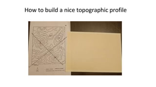
Drawing a profile
- 1. How to build a nice topographic profile
- 2. Mark initial point 2 cm away from the margin
- 3. Fold the margin Fix your letter A with the one in the map and mark final point (B) in the graph paper
- 4. Mark in the margin every contour line that you come accross
- 5. Mark the elevations that you know looking at the countour lines
- 6. Complete the information for every mark
- 7. Unfold the graph paper again. Use the horizontal scale to calculate the space needed to represent your profile Make sure your highest elevation will be included in the graph Leave 2 or 3 cm and draw the grids of your graph including letters A and B
- 8. Mark the height represented in the axis of the graph (including the units).
- 9. Locate each dot in the graph considering its elevation
- 10. Join the dots together forming a natural profile. Do not ignore the original map, especially to complete the edges and to mark the top of the hills
- 11. Write down the scale
- 12. Draw a nice graphic scale