SlideShare a Scribd company logo
1 of 2
Download to read offline
Let's Try       For U & Me


 Map-Making
with QGIS                                                                                                          ­Part—1

Have you ever wondered how maps are made? In this article, we will take our first step towards
making maps from spatial data using Quantum Geographic Information System (QGIS).


Q
         GIS is one of the most
         widely used open source
         desktop tools for map-
making and basic GIS analysis.
You can download it from http://
download.qgis.org. QGIS is useful
for visualising and editing spatial
data, and for querying its features.
Features are the geographical objects
in the layer, e.g., each individual
airport is a feature in the airports
layer. A feature will have attributes
describing it, such as the geometry,
name, category, etc.
    QGIS has a Map Composer,
which allows you to add the essential
map elements and get the map print-       Figure 1: Alaska and Airports shapefiles
ready. QGIS comes with dozens
of handy plug-ins, and a Python
console, just in case developers want
to interact with the data through the
command interface. For this tutorial,
we will be using version 1.7.3 with
the Alaska dataset available at http://
download.osgeo.org/qgis/data/qgis_
sample_data.zip.

Visualise shapefiles
QGIS supports most common vector
file formats—Shapefile, KML,
GML, GPX, etc. The procedure to
open the files is the same for all
formats:
1.	 On the menu, click Add Vector
    Layer.                                Figure 2: Layer styles


                                                                                     www.LinuxForU.com  | LINUX For You  | JUNE 2012  |  31
For U & Me              Let's Try

2.	 Browse to the source (for our
    example, the qgis_sample_data/
    shapefiles directory).
3.	 Select the files (in our case, alaska.
    shp and airports.shp). Figure 1
    shows the Map Canvas with the
    Alaska and Airports layers.

Layer styles
Styling allows us to set fill colours,
patterns, borders, icons, etc, for the
features in the layer:
1.	 Right click the Airport layer in the
    Layers panel and select Properties.
2.	 Under the Style tab you can
    change the symbol and colour,
    the size of the symbol, set
    transparency, and categorise the
    features (see Figure 2).

Layer labels
                                                Figure 3: Feature labels
Labels are text identifiers for features in
the layer. QGIS allows you to choose the
attribute you want to show as the label,
and set its style too (see Figure 3):
1.	 Right click the Airport layer and
     select Properties.
2.	 Under the Labels tab, check mark
     Display Labels.
3.	 Select the Field Containing Label; this
     is the text to be shown on the layer.
4.	 Set the font size, colour, type, and
     the text position with respect to the
     feature location.

Attributes table
Attributes describe the features in
a layer. The attribute values can be
edited and queried. To view attribute
names and data, right click the Airport
layer and choose Open Attribute Table.
     To query features of your interest,
add the text to filter the data in the Look     Figure 4: Feature selection
For text box, and select the desired field.
For instance: look for ‘Military’ in the        format as ESRI Shapefile and save.            publish a map, plot custom data and
field ‘Cat’. Then hit Search. You will             In Part II, we will learn how to           perform geoprocessing.
find that all military airports are selected
and highlighted in the Attribute Table,           By: Sagar Arlekar & Niket Narang
as in Figure 4, and on the map. For               The authors are researchers at the Center for Study of Science, Technology
complex queries, try Advanced Search.             and Policy (CSTEP), Bengalore. They work in the fields of GIS and Agent-Based
     Selected features can be saved as            Simulation. At CSTEP they have built a web-based GIS framework to simulate and
                                                  visualize disaster impact. They love working with open source tools and are active
a new shapefile: click Layer > Save
                                                  contributors to Openstreetmaps.
Selection as vector file. Select the


32  |  JUNE 2012  | LINUX For You  |  www.LinuxForU.com

More Related Content

What's hot

ePOM - Intro to Ocean Data Science - Raster and Vector Data Formats
ePOM - Intro to Ocean Data Science - Raster and Vector Data FormatsePOM - Intro to Ocean Data Science - Raster and Vector Data Formats
ePOM - Intro to Ocean Data Science - Raster and Vector Data FormatsGiuseppe Masetti
 
Data Models - GIS I
Data Models - GIS IData Models - GIS I
Data Models - GIS IJohn Reiser
 
Exploring spatial data in GIS Environment
Exploring spatial data in GIS Environment Exploring spatial data in GIS Environment
Exploring spatial data in GIS Environment NAXA-Developers
 
Ahmad Mauliddin Vol Of Water In Bili Bili
Ahmad Mauliddin Vol Of Water In Bili BiliAhmad Mauliddin Vol Of Water In Bili Bili
Ahmad Mauliddin Vol Of Water In Bili BiliHartanto Sanjaya
 
Analytic mapping 2013
Analytic mapping 2013Analytic mapping 2013
Analytic mapping 2013David Herzog
 
Introduction to ArcGIS 10.1
Introduction to ArcGIS 10.1Introduction to ArcGIS 10.1
Introduction to ArcGIS 10.1Claudio Montoni
 
First GIS Software that Convert GIS Shape files to HTML Google Map Web Site a...
First GIS Software that Convert GIS Shape files to HTML Google Map Web Site a...First GIS Software that Convert GIS Shape files to HTML Google Map Web Site a...
First GIS Software that Convert GIS Shape files to HTML Google Map Web Site a...Gis Gis
 
Plugins in QGIS and its uses
Plugins in QGIS and its usesPlugins in QGIS and its uses
Plugins in QGIS and its usesMayuresh Padalkar
 
QGIS Module 3
QGIS Module 3QGIS Module 3
QGIS Module 3CAPSUCSF
 
Module for principles and application of precision agriculture
Module for principles and application of precision agricultureModule for principles and application of precision agriculture
Module for principles and application of precision agricultureJAWI Herbs Centre
 
Digitization and 3d modelling of a mine plan
Digitization and 3d modelling of a mine planDigitization and 3d modelling of a mine plan
Digitization and 3d modelling of a mine planSafdar Ali
 
Integrating Geospatial Data to your Applications
Integrating Geospatial Data to your ApplicationsIntegrating Geospatial Data to your Applications
Integrating Geospatial Data to your ApplicationsIan Panganiban
 

What's hot (20)

QGIS training class 1
QGIS training class 1QGIS training class 1
QGIS training class 1
 
ePOM - Intro to Ocean Data Science - Raster and Vector Data Formats
ePOM - Intro to Ocean Data Science - Raster and Vector Data FormatsePOM - Intro to Ocean Data Science - Raster and Vector Data Formats
ePOM - Intro to Ocean Data Science - Raster and Vector Data Formats
 
Data Models - GIS I
Data Models - GIS IData Models - GIS I
Data Models - GIS I
 
Exploring spatial data in GIS Environment
Exploring spatial data in GIS Environment Exploring spatial data in GIS Environment
Exploring spatial data in GIS Environment
 
survey paper 2
survey paper 2survey paper 2
survey paper 2
 
QGIS Tutorial 1
QGIS Tutorial 1QGIS Tutorial 1
QGIS Tutorial 1
 
Ahmad Mauliddin Vol Of Water In Bili Bili
Ahmad Mauliddin Vol Of Water In Bili BiliAhmad Mauliddin Vol Of Water In Bili Bili
Ahmad Mauliddin Vol Of Water In Bili Bili
 
Analytic mapping 2013
Analytic mapping 2013Analytic mapping 2013
Analytic mapping 2013
 
Introduction to ArcGIS 10.1
Introduction to ArcGIS 10.1Introduction to ArcGIS 10.1
Introduction to ArcGIS 10.1
 
Google Earth
Google EarthGoogle Earth
Google Earth
 
What is gis
What is gisWhat is gis
What is gis
 
First GIS Software that Convert GIS Shape files to HTML Google Map Web Site a...
First GIS Software that Convert GIS Shape files to HTML Google Map Web Site a...First GIS Software that Convert GIS Shape files to HTML Google Map Web Site a...
First GIS Software that Convert GIS Shape files to HTML Google Map Web Site a...
 
QGIS training class 3
QGIS training class 3QGIS training class 3
QGIS training class 3
 
Plugins in QGIS and its uses
Plugins in QGIS and its usesPlugins in QGIS and its uses
Plugins in QGIS and its uses
 
QGIS Module 3
QGIS Module 3QGIS Module 3
QGIS Module 3
 
Module for principles and application of precision agriculture
Module for principles and application of precision agricultureModule for principles and application of precision agriculture
Module for principles and application of precision agriculture
 
Digitization and 3d modelling of a mine plan
Digitization and 3d modelling of a mine planDigitization and 3d modelling of a mine plan
Digitization and 3d modelling of a mine plan
 
functions of GIS
functions of GISfunctions of GIS
functions of GIS
 
Integrating Geospatial Data to your Applications
Integrating Geospatial Data to your ApplicationsIntegrating Geospatial Data to your Applications
Integrating Geospatial Data to your Applications
 
Case study of goggle map
Case study of goggle mapCase study of goggle map
Case study of goggle map
 

Viewers also liked

Rails Plugins - Linux For You, March 2011 Issue
Rails Plugins - Linux For You, March 2011 IssueRails Plugins - Linux For You, March 2011 Issue
Rails Plugins - Linux For You, March 2011 IssueSagar Arlekar
 
Rails and twitter #twtr_hack
Rails and twitter #twtr_hackRails and twitter #twtr_hack
Rails and twitter #twtr_hacki7a
 
Map Making with QGIS - Part II
Map Making with QGIS - Part IIMap Making with QGIS - Part II
Map Making with QGIS - Part IISagar Arlekar
 

Viewers also liked (8)

Rails Plugins - Linux For You, March 2011 Issue
Rails Plugins - Linux For You, March 2011 IssueRails Plugins - Linux For You, March 2011 Issue
Rails Plugins - Linux For You, March 2011 Issue
 
Rails e suas Gems
Rails e suas GemsRails e suas Gems
Rails e suas Gems
 
Rails and twitter #twtr_hack
Rails and twitter #twtr_hackRails and twitter #twtr_hack
Rails and twitter #twtr_hack
 
Ruby gems
Ruby gemsRuby gems
Ruby gems
 
Map Making with QGIS - Part II
Map Making with QGIS - Part IIMap Making with QGIS - Part II
Map Making with QGIS - Part II
 
Omniauth
OmniauthOmniauth
Omniauth
 
Some OAuth love
Some OAuth loveSome OAuth love
Some OAuth love
 
APIs for mobile
APIs for mobileAPIs for mobile
APIs for mobile
 

Similar to Map Making with QGIS

Nycct GIS_primer tutorial
Nycct  GIS_primer tutorialNycct  GIS_primer tutorial
Nycct GIS_primer tutorialNYCCTfab
 
RS and GIS TW- 1&2.pdf
RS and GIS TW- 1&2.pdfRS and GIS TW- 1&2.pdf
RS and GIS TW- 1&2.pdfSatishKhadse3
 
Concepts and Methods of Embedding Statistical Data into Maps
Concepts and Methods of Embedding Statistical Data into MapsConcepts and Methods of Embedding Statistical Data into Maps
Concepts and Methods of Embedding Statistical Data into MapsMohammad Liton Hossain
 
QGIS Training.pptx
QGIS Training.pptxQGIS Training.pptx
QGIS Training.pptxSeemaAjay7
 
ArcGIS API for Javascript Tutorial
ArcGIS API for Javascript TutorialArcGIS API for Javascript Tutorial
ArcGIS API for Javascript TutorialMohammed Mahmoud
 
Introduction to gis
Introduction to gisIntroduction to gis
Introduction to gisJay_mittal
 
GIS 5103 – Fundamentals of GISLecture 83D GIS.docx
GIS 5103 – Fundamentals of GISLecture 83D GIS.docxGIS 5103 – Fundamentals of GISLecture 83D GIS.docx
GIS 5103 – Fundamentals of GISLecture 83D GIS.docxshericehewat
 
SD-miner System to Retrieve Probabilistic Neighborhood Points in Spatial Dat...
SD-miner System to Retrieve Probabilistic Neighborhood Points  in Spatial Dat...SD-miner System to Retrieve Probabilistic Neighborhood Points  in Spatial Dat...
SD-miner System to Retrieve Probabilistic Neighborhood Points in Spatial Dat...IOSR Journals
 
Manual to basic gis
Manual to basic gisManual to basic gis
Manual to basic gisQust04
 
Concepts and Methods of Embedding Statistical Data into Maps
Concepts and Methods of Embedding Statistical Data into MapsConcepts and Methods of Embedding Statistical Data into Maps
Concepts and Methods of Embedding Statistical Data into MapsMohammad Liton Hossain
 
Concepts and Methods of Embedding Statistical Data into Maps
Concepts and Methods of Embedding Statistical Data into Maps Concepts and Methods of Embedding Statistical Data into Maps
Concepts and Methods of Embedding Statistical Data into Maps IJSRP Journal
 
GIS Ppt 5.pptx: SPACIAL DATA ANALSYSISIS
GIS Ppt 5.pptx: SPACIAL DATA ANALSYSISISGIS Ppt 5.pptx: SPACIAL DATA ANALSYSISIS
GIS Ppt 5.pptx: SPACIAL DATA ANALSYSISISmulugeta48
 
2017 PLSC Track: Using a Standard Version of ArcMap with External VRS Recieve...
2017 PLSC Track: Using a Standard Version of ArcMap with External VRS Recieve...2017 PLSC Track: Using a Standard Version of ArcMap with External VRS Recieve...
2017 PLSC Track: Using a Standard Version of ArcMap with External VRS Recieve...GIS in the Rockies
 
Opensource gis development - part 5
Opensource gis development - part 5Opensource gis development - part 5
Opensource gis development - part 5Andrea Antonello
 
Feature Analyst Extraction of Lockheed Martin building using ArcGIS
Feature Analyst Extraction of Lockheed Martin building using ArcGISFeature Analyst Extraction of Lockheed Martin building using ArcGIS
Feature Analyst Extraction of Lockheed Martin building using ArcGISAriez Reyes
 

Similar to Map Making with QGIS (20)

Nycct GIS_primer tutorial
Nycct  GIS_primer tutorialNycct  GIS_primer tutorial
Nycct GIS_primer tutorial
 
RS and GIS TW- 1&2.pdf
RS and GIS TW- 1&2.pdfRS and GIS TW- 1&2.pdf
RS and GIS TW- 1&2.pdf
 
Geoprocessing
GeoprocessingGeoprocessing
Geoprocessing
 
Concepts and Methods of Embedding Statistical Data into Maps
Concepts and Methods of Embedding Statistical Data into MapsConcepts and Methods of Embedding Statistical Data into Maps
Concepts and Methods of Embedding Statistical Data into Maps
 
QGIS Training.pptx
QGIS Training.pptxQGIS Training.pptx
QGIS Training.pptx
 
ArcGIS API for Javascript Tutorial
ArcGIS API for Javascript TutorialArcGIS API for Javascript Tutorial
ArcGIS API for Javascript Tutorial
 
Introduction to gis
Introduction to gisIntroduction to gis
Introduction to gis
 
GIS_Intro_March_2014
GIS_Intro_March_2014GIS_Intro_March_2014
GIS_Intro_March_2014
 
GIS 5103 – Fundamentals of GISLecture 83D GIS.docx
GIS 5103 – Fundamentals of GISLecture 83D GIS.docxGIS 5103 – Fundamentals of GISLecture 83D GIS.docx
GIS 5103 – Fundamentals of GISLecture 83D GIS.docx
 
SD-miner System to Retrieve Probabilistic Neighborhood Points in Spatial Dat...
SD-miner System to Retrieve Probabilistic Neighborhood Points  in Spatial Dat...SD-miner System to Retrieve Probabilistic Neighborhood Points  in Spatial Dat...
SD-miner System to Retrieve Probabilistic Neighborhood Points in Spatial Dat...
 
Manual to basic gis
Manual to basic gisManual to basic gis
Manual to basic gis
 
Concepts and Methods of Embedding Statistical Data into Maps
Concepts and Methods of Embedding Statistical Data into MapsConcepts and Methods of Embedding Statistical Data into Maps
Concepts and Methods of Embedding Statistical Data into Maps
 
Concepts and Methods of Embedding Statistical Data into Maps
Concepts and Methods of Embedding Statistical Data into Maps Concepts and Methods of Embedding Statistical Data into Maps
Concepts and Methods of Embedding Statistical Data into Maps
 
GIS Ppt 5.pptx: SPACIAL DATA ANALSYSISIS
GIS Ppt 5.pptx: SPACIAL DATA ANALSYSISISGIS Ppt 5.pptx: SPACIAL DATA ANALSYSISIS
GIS Ppt 5.pptx: SPACIAL DATA ANALSYSISIS
 
02+ +step+by+step+qgis
02+ +step+by+step+qgis02+ +step+by+step+qgis
02+ +step+by+step+qgis
 
2017 PLSC Track: Using a Standard Version of ArcMap with External VRS Recieve...
2017 PLSC Track: Using a Standard Version of ArcMap with External VRS Recieve...2017 PLSC Track: Using a Standard Version of ArcMap with External VRS Recieve...
2017 PLSC Track: Using a Standard Version of ArcMap with External VRS Recieve...
 
A practical guide to GIS in Civil 3D
A practical guide to GIS in Civil 3DA practical guide to GIS in Civil 3D
A practical guide to GIS in Civil 3D
 
High res cartographic modeling lab
High res cartographic modeling labHigh res cartographic modeling lab
High res cartographic modeling lab
 
Opensource gis development - part 5
Opensource gis development - part 5Opensource gis development - part 5
Opensource gis development - part 5
 
Feature Analyst Extraction of Lockheed Martin building using ArcGIS
Feature Analyst Extraction of Lockheed Martin building using ArcGISFeature Analyst Extraction of Lockheed Martin building using ArcGIS
Feature Analyst Extraction of Lockheed Martin building using ArcGIS
 

More from Sagar Arlekar

PostgreSQL Modules Tutorial - chkpass, hstore, fuzzystrmach, isn
PostgreSQL Modules Tutorial - chkpass, hstore, fuzzystrmach, isn PostgreSQL Modules Tutorial - chkpass, hstore, fuzzystrmach, isn
PostgreSQL Modules Tutorial - chkpass, hstore, fuzzystrmach, isn Sagar Arlekar
 
Foodlets in Business Goa Magazine
Foodlets in Business Goa MagazineFoodlets in Business Goa Magazine
Foodlets in Business Goa MagazineSagar Arlekar
 
The Foodlets Business Plan Released
The Foodlets Business Plan ReleasedThe Foodlets Business Plan Released
The Foodlets Business Plan ReleasedSagar Arlekar
 
Foodlets Team Interview - Navhind Times
Foodlets Team Interview - Navhind TimesFoodlets Team Interview - Navhind Times
Foodlets Team Interview - Navhind TimesSagar Arlekar
 
Getting Started - Creating products and services that make life better
Getting Started - Creating products and services that make life betterGetting Started - Creating products and services that make life better
Getting Started - Creating products and services that make life betterSagar Arlekar
 
Getting Started - Going out and creating a change
Getting Started - Going out and creating a changeGetting Started - Going out and creating a change
Getting Started - Going out and creating a changeSagar Arlekar
 

More from Sagar Arlekar (6)

PostgreSQL Modules Tutorial - chkpass, hstore, fuzzystrmach, isn
PostgreSQL Modules Tutorial - chkpass, hstore, fuzzystrmach, isn PostgreSQL Modules Tutorial - chkpass, hstore, fuzzystrmach, isn
PostgreSQL Modules Tutorial - chkpass, hstore, fuzzystrmach, isn
 
Foodlets in Business Goa Magazine
Foodlets in Business Goa MagazineFoodlets in Business Goa Magazine
Foodlets in Business Goa Magazine
 
The Foodlets Business Plan Released
The Foodlets Business Plan ReleasedThe Foodlets Business Plan Released
The Foodlets Business Plan Released
 
Foodlets Team Interview - Navhind Times
Foodlets Team Interview - Navhind TimesFoodlets Team Interview - Navhind Times
Foodlets Team Interview - Navhind Times
 
Getting Started - Creating products and services that make life better
Getting Started - Creating products and services that make life betterGetting Started - Creating products and services that make life better
Getting Started - Creating products and services that make life better
 
Getting Started - Going out and creating a change
Getting Started - Going out and creating a changeGetting Started - Going out and creating a change
Getting Started - Going out and creating a change
 

Recently uploaded

Software Engineering Methodologies (overview)
Software Engineering Methodologies (overview)Software Engineering Methodologies (overview)
Software Engineering Methodologies (overview)eniolaolutunde
 
The byproduct of sericulture in different industries.pptx
The byproduct of sericulture in different industries.pptxThe byproduct of sericulture in different industries.pptx
The byproduct of sericulture in different industries.pptxShobhayan Kirtania
 
1029-Danh muc Sach Giao Khoa khoi 6.pdf
1029-Danh muc Sach Giao Khoa khoi  6.pdf1029-Danh muc Sach Giao Khoa khoi  6.pdf
1029-Danh muc Sach Giao Khoa khoi 6.pdfQucHHunhnh
 
Paris 2024 Olympic Geographies - an activity
Paris 2024 Olympic Geographies - an activityParis 2024 Olympic Geographies - an activity
Paris 2024 Olympic Geographies - an activityGeoBlogs
 
Russian Call Girls in Andheri Airport Mumbai WhatsApp 9167673311 💞 Full Nigh...
Russian Call Girls in Andheri Airport Mumbai WhatsApp  9167673311 💞 Full Nigh...Russian Call Girls in Andheri Airport Mumbai WhatsApp  9167673311 💞 Full Nigh...
Russian Call Girls in Andheri Airport Mumbai WhatsApp 9167673311 💞 Full Nigh...Pooja Nehwal
 
The basics of sentences session 2pptx copy.pptx
The basics of sentences session 2pptx copy.pptxThe basics of sentences session 2pptx copy.pptx
The basics of sentences session 2pptx copy.pptxheathfieldcps1
 
9548086042 for call girls in Indira Nagar with room service
9548086042  for call girls in Indira Nagar  with room service9548086042  for call girls in Indira Nagar  with room service
9548086042 for call girls in Indira Nagar with room servicediscovermytutordmt
 
Introduction to Nonprofit Accounting: The Basics
Introduction to Nonprofit Accounting: The BasicsIntroduction to Nonprofit Accounting: The Basics
Introduction to Nonprofit Accounting: The BasicsTechSoup
 
Nutritional Needs Presentation - HLTH 104
Nutritional Needs Presentation - HLTH 104Nutritional Needs Presentation - HLTH 104
Nutritional Needs Presentation - HLTH 104misteraugie
 
Grant Readiness 101 TechSoup and Remy Consulting
Grant Readiness 101 TechSoup and Remy ConsultingGrant Readiness 101 TechSoup and Remy Consulting
Grant Readiness 101 TechSoup and Remy ConsultingTechSoup
 
CARE OF CHILD IN INCUBATOR..........pptx
CARE OF CHILD IN INCUBATOR..........pptxCARE OF CHILD IN INCUBATOR..........pptx
CARE OF CHILD IN INCUBATOR..........pptxGaneshChakor2
 
microwave assisted reaction. General introduction
microwave assisted reaction. General introductionmicrowave assisted reaction. General introduction
microwave assisted reaction. General introductionMaksud Ahmed
 
Arihant handbook biology for class 11 .pdf
Arihant handbook biology for class 11 .pdfArihant handbook biology for class 11 .pdf
Arihant handbook biology for class 11 .pdfchloefrazer622
 
Presentation by Andreas Schleicher Tackling the School Absenteeism Crisis 30 ...
Presentation by Andreas Schleicher Tackling the School Absenteeism Crisis 30 ...Presentation by Andreas Schleicher Tackling the School Absenteeism Crisis 30 ...
Presentation by Andreas Schleicher Tackling the School Absenteeism Crisis 30 ...EduSkills OECD
 
Disha NEET Physics Guide for classes 11 and 12.pdf
Disha NEET Physics Guide for classes 11 and 12.pdfDisha NEET Physics Guide for classes 11 and 12.pdf
Disha NEET Physics Guide for classes 11 and 12.pdfchloefrazer622
 
Measures of Central Tendency: Mean, Median and Mode
Measures of Central Tendency: Mean, Median and ModeMeasures of Central Tendency: Mean, Median and Mode
Measures of Central Tendency: Mean, Median and ModeThiyagu K
 
Accessible design: Minimum effort, maximum impact
Accessible design: Minimum effort, maximum impactAccessible design: Minimum effort, maximum impact
Accessible design: Minimum effort, maximum impactdawncurless
 
Student login on Anyboli platform.helpin
Student login on Anyboli platform.helpinStudent login on Anyboli platform.helpin
Student login on Anyboli platform.helpinRaunakKeshri1
 

Recently uploaded (20)

Software Engineering Methodologies (overview)
Software Engineering Methodologies (overview)Software Engineering Methodologies (overview)
Software Engineering Methodologies (overview)
 
Advance Mobile Application Development class 07
Advance Mobile Application Development class 07Advance Mobile Application Development class 07
Advance Mobile Application Development class 07
 
The byproduct of sericulture in different industries.pptx
The byproduct of sericulture in different industries.pptxThe byproduct of sericulture in different industries.pptx
The byproduct of sericulture in different industries.pptx
 
1029-Danh muc Sach Giao Khoa khoi 6.pdf
1029-Danh muc Sach Giao Khoa khoi  6.pdf1029-Danh muc Sach Giao Khoa khoi  6.pdf
1029-Danh muc Sach Giao Khoa khoi 6.pdf
 
Paris 2024 Olympic Geographies - an activity
Paris 2024 Olympic Geographies - an activityParis 2024 Olympic Geographies - an activity
Paris 2024 Olympic Geographies - an activity
 
INDIA QUIZ 2024 RLAC DELHI UNIVERSITY.pptx
INDIA QUIZ 2024 RLAC DELHI UNIVERSITY.pptxINDIA QUIZ 2024 RLAC DELHI UNIVERSITY.pptx
INDIA QUIZ 2024 RLAC DELHI UNIVERSITY.pptx
 
Russian Call Girls in Andheri Airport Mumbai WhatsApp 9167673311 💞 Full Nigh...
Russian Call Girls in Andheri Airport Mumbai WhatsApp  9167673311 💞 Full Nigh...Russian Call Girls in Andheri Airport Mumbai WhatsApp  9167673311 💞 Full Nigh...
Russian Call Girls in Andheri Airport Mumbai WhatsApp 9167673311 💞 Full Nigh...
 
The basics of sentences session 2pptx copy.pptx
The basics of sentences session 2pptx copy.pptxThe basics of sentences session 2pptx copy.pptx
The basics of sentences session 2pptx copy.pptx
 
9548086042 for call girls in Indira Nagar with room service
9548086042  for call girls in Indira Nagar  with room service9548086042  for call girls in Indira Nagar  with room service
9548086042 for call girls in Indira Nagar with room service
 
Introduction to Nonprofit Accounting: The Basics
Introduction to Nonprofit Accounting: The BasicsIntroduction to Nonprofit Accounting: The Basics
Introduction to Nonprofit Accounting: The Basics
 
Nutritional Needs Presentation - HLTH 104
Nutritional Needs Presentation - HLTH 104Nutritional Needs Presentation - HLTH 104
Nutritional Needs Presentation - HLTH 104
 
Grant Readiness 101 TechSoup and Remy Consulting
Grant Readiness 101 TechSoup and Remy ConsultingGrant Readiness 101 TechSoup and Remy Consulting
Grant Readiness 101 TechSoup and Remy Consulting
 
CARE OF CHILD IN INCUBATOR..........pptx
CARE OF CHILD IN INCUBATOR..........pptxCARE OF CHILD IN INCUBATOR..........pptx
CARE OF CHILD IN INCUBATOR..........pptx
 
microwave assisted reaction. General introduction
microwave assisted reaction. General introductionmicrowave assisted reaction. General introduction
microwave assisted reaction. General introduction
 
Arihant handbook biology for class 11 .pdf
Arihant handbook biology for class 11 .pdfArihant handbook biology for class 11 .pdf
Arihant handbook biology for class 11 .pdf
 
Presentation by Andreas Schleicher Tackling the School Absenteeism Crisis 30 ...
Presentation by Andreas Schleicher Tackling the School Absenteeism Crisis 30 ...Presentation by Andreas Schleicher Tackling the School Absenteeism Crisis 30 ...
Presentation by Andreas Schleicher Tackling the School Absenteeism Crisis 30 ...
 
Disha NEET Physics Guide for classes 11 and 12.pdf
Disha NEET Physics Guide for classes 11 and 12.pdfDisha NEET Physics Guide for classes 11 and 12.pdf
Disha NEET Physics Guide for classes 11 and 12.pdf
 
Measures of Central Tendency: Mean, Median and Mode
Measures of Central Tendency: Mean, Median and ModeMeasures of Central Tendency: Mean, Median and Mode
Measures of Central Tendency: Mean, Median and Mode
 
Accessible design: Minimum effort, maximum impact
Accessible design: Minimum effort, maximum impactAccessible design: Minimum effort, maximum impact
Accessible design: Minimum effort, maximum impact
 
Student login on Anyboli platform.helpin
Student login on Anyboli platform.helpinStudent login on Anyboli platform.helpin
Student login on Anyboli platform.helpin
 

Map Making with QGIS

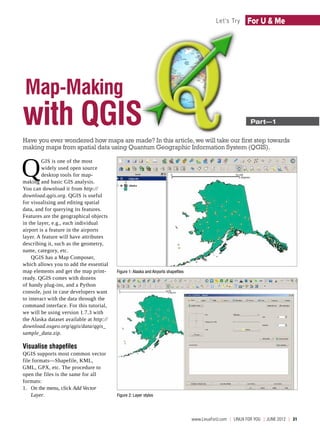
  • 1. Let's Try For U & Me Map-Making with QGIS ­Part—1 Have you ever wondered how maps are made? In this article, we will take our first step towards making maps from spatial data using Quantum Geographic Information System (QGIS). Q GIS is one of the most widely used open source desktop tools for map- making and basic GIS analysis. You can download it from http:// download.qgis.org. QGIS is useful for visualising and editing spatial data, and for querying its features. Features are the geographical objects in the layer, e.g., each individual airport is a feature in the airports layer. A feature will have attributes describing it, such as the geometry, name, category, etc. QGIS has a Map Composer, which allows you to add the essential map elements and get the map print- Figure 1: Alaska and Airports shapefiles ready. QGIS comes with dozens of handy plug-ins, and a Python console, just in case developers want to interact with the data through the command interface. For this tutorial, we will be using version 1.7.3 with the Alaska dataset available at http:// download.osgeo.org/qgis/data/qgis_ sample_data.zip. Visualise shapefiles QGIS supports most common vector file formats—Shapefile, KML, GML, GPX, etc. The procedure to open the files is the same for all formats: 1. On the menu, click Add Vector Layer. Figure 2: Layer styles www.LinuxForU.com  | LINUX For You  | JUNE 2012  |  31
  • 2. For U & Me Let's Try 2. Browse to the source (for our example, the qgis_sample_data/ shapefiles directory). 3. Select the files (in our case, alaska. shp and airports.shp). Figure 1 shows the Map Canvas with the Alaska and Airports layers. Layer styles Styling allows us to set fill colours, patterns, borders, icons, etc, for the features in the layer: 1. Right click the Airport layer in the Layers panel and select Properties. 2. Under the Style tab you can change the symbol and colour, the size of the symbol, set transparency, and categorise the features (see Figure 2). Layer labels Figure 3: Feature labels Labels are text identifiers for features in the layer. QGIS allows you to choose the attribute you want to show as the label, and set its style too (see Figure 3): 1. Right click the Airport layer and select Properties. 2. Under the Labels tab, check mark Display Labels. 3. Select the Field Containing Label; this is the text to be shown on the layer. 4. Set the font size, colour, type, and the text position with respect to the feature location. Attributes table Attributes describe the features in a layer. The attribute values can be edited and queried. To view attribute names and data, right click the Airport layer and choose Open Attribute Table. To query features of your interest, add the text to filter the data in the Look Figure 4: Feature selection For text box, and select the desired field. For instance: look for ‘Military’ in the format as ESRI Shapefile and save. publish a map, plot custom data and field ‘Cat’. Then hit Search. You will In Part II, we will learn how to perform geoprocessing. find that all military airports are selected and highlighted in the Attribute Table, By: Sagar Arlekar & Niket Narang as in Figure 4, and on the map. For The authors are researchers at the Center for Study of Science, Technology complex queries, try Advanced Search. and Policy (CSTEP), Bengalore. They work in the fields of GIS and Agent-Based Selected features can be saved as Simulation. At CSTEP they have built a web-based GIS framework to simulate and visualize disaster impact. They love working with open source tools and are active a new shapefile: click Layer > Save contributors to Openstreetmaps. Selection as vector file. Select the 32  |  JUNE 2012  | LINUX For You  |  www.LinuxForU.com