Cavities detection with ground penetrating radar in limestone dominated rock formation

As one of geophysical method ground penetrating radar uses electromagnetic wave propagation to detecting the anomaly object, the strong relationship between the physical properties of geological material and their electromagnetic properties enable to identification of physical structures in the sub surface. Cavities in limestone dominated rock formation sometimes made problem when construction build above in this area, as prevention to the damage affected by cavities, before construction starting to build we have to identified the possible cave location to preparing special treatment to minimize the risk. Present of cavities give electromagnetic anomaly event and the reflection signal representing changing of electrical properties when we use ground penetrating radar. We applied attributes extraction adopted from seismic method to extracting information about cavities. We use sweetness attribute extraction to identified present of cavities in limestone dominated rock formation

Recommended
Recommended
More Related Content
What's hot
What's hot (20)
Similar to Cavities detection with ground penetrating radar in limestone dominated rock formation
Similar to Cavities detection with ground penetrating radar in limestone dominated rock formation (20)
Recently uploaded
Recently uploaded (20)
Cavities detection with ground penetrating radar in limestone dominated rock formation
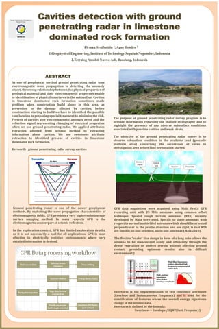
- 1. ABSTRACT As one of geophysical method ground penetrating radar uses electromagnetic wave propagation to detecting the anomaly object, the strong relationship between the physical properties of geological material and their electromagnetic properties enable to identification of physical structures in the sub surface. Cavities in limestone dominated rock formation sometimes made problem when construction build above in this area, as prevention to the damage affected by cavities, before construction starting to build we have to identified the possible cave location to preparing special treatment to minimize the risk. Present of cavities give electromagnetic anomaly event and the reflection signal representing changing of electrical properties when we use ground penetrating radar. We applied attributes extraction adopted from seismic method to extracting information about cavities. We use sweetness attribute extraction to identified present of cavities in limestone dominated rock formation. Keywords : ground penetrating radar survey, cavities Firman Syaifuddin 1, Agus Hendro 2 1.Geophysical Engineering, Institute of Technology Sepuluh Nopember, Indonesia 2.Terralog Amukti Nuswa Adi, Bandung, Indonesia Sweetness is the implementation of two combined attributes (Envelope and Instantaneous Frequency) and is used for the identification of features where the overall energy signatures change in the seismic data. Sweetness is defined by the formula: Sweetness = Envelope / SQRT(Inst. Frequency) The purpose of ground penetrating radar survey program is to provide information regarding the shallow stratigraphy and to highlight the presence of any adverse subsurface conditions associated with possible cavities and weak strata. The objective of the ground penetrating radar survey is to observe subsurface condition in the available land (geocycle platform area) concerning the occurrence of caves in investigation area before land preparation started. Ground penetrating radar is one of the newer geophysical methods. By exploiting the wave propagation characteristics of electromagnetic fields, GPR provides a very high resolution sub- surface mapping method. In many respects GPR is the electromagnetic counterpart of seismic reflection. In the exploration context, GPR has limited exploration depths, so it is not necessarily a tool for all applications. GPR is most effective in electrically resistive environments where very detailed information is desired. GPR data acquisition were acquired using Mala ProEx GPR recording unit with 25 MHz antennas using common offset technique. Special rough terrain antennas (RTA) recently developed by Mala were used. Specific to these antennas with respect to normal unshielded antennas which should be oriented perpendicular to the profile direction and are rigid, is that RTA are flexible, in-line oriented, all-in-one antennas (Mala 2010). The flexible “snake” like design in form of a long tube allows the antenna to be maneuvered easily and efficiently through the dense vegetation or uneven terrain without affecting ground contact, providing optimum results also in difficult environment.)
- 2. The guide for identification of occurrence of cavities in limestone environment refer to the fact that between the karst cavities with the low velocity within the dense limestone with high-velocity may generate strong reflection. In this study we applied the sweetness to detect occurrences of cavities. In general, karst cavities in limestone environment mainly occur below or near the erosion surface and an interference phenomenon may occur between strong reflection of the erosion surface and the reflection of the cavity formation. To asses the capabilities of low frequency GPR and to investigate the possible existence of unknown cave galleries, we planned 24 profiles oriented in N–S direction and 18 profiles in W-E direction. Acquisition parameters are summarized in Table below. Sampling interval was 1 ns and the acquisition window length 1024 ns. The surface soil layer and limestone beneath were therefore relatively dry. High sweetness marked by magenta to pink color and the low sweetness value marked by blue color. Range relative value of sweetness is 0 up to 1. The phenomenon of cavities in carbonate (limestone) environment occur with the strong reflection (high contrast impendence) give higher envelope amplitude and low frequency. The sweetness sections were also used to display the energy distribution of the traces as shown in the figures of all the profiles. The phenomenon of cavities in carbonate (limestone) environment occur with the strong reflection (high contrast impendence) give higher envelope amplitude and low frequency. Fluid filled in limestone makes absorbed high frequency component of radar data. On other word phenomenon of occurrence cavities will be have high sweetness value. Ground-penetrating radar was successfully utilized to map the occurrence of cavities or fissure at this Platform area. Digital processing and modeling of georadar data enhanced the interpretation of cavities and provided detailed information of position and distribution of cavity at the project site. 43 of cavities with various dimension and depth have been identified and geometry of caves can be presented on 2D map