
Recommended
More Related Content
Similar to Ground Penetrating Radar Survey
Similar to Ground Penetrating Radar Survey (20)
More from NeerajMudgil1
More from NeerajMudgil1 (20)
Recently uploaded
Recently uploaded (20)
Ground Penetrating Radar Survey
- 1. Ground Penetrating Radar Survey | GPR | SUE Survey in India EpitomeGS is a Ground Penetrating Radar Survey company in India. Our Services are GPR, SUE, Underground Utility, Underground Scanning & Mapping survey in India. GPR is: A geophysical- approach that is, precise, fast and high-resolution for subsurface investigation. Non-invasive, non-destructive and completely safe procedure. One and only possible non-intrusive method capable of accurately locating non- metallic subsurface features and utilities (example- clay, concrete, fiberglass, PVC conduits or fiber-optic cables). A geophysical survey technique based on transmitting pulsed electromagnetic (EM) energy into the subsurface and ascertaining the strength of the reflected energy. Effective in case enough contrast in material properties (dielectric permittivity) between a buried target and its surroundings exists. Applied by Epitome in order to detect and map buried pipes, cables, structural reinforcement, voids, disturbed ground, material degradation, subsurface layers and buried objects. Gained by use of transmitting and receiving antennae which can be mounted on a cart, skid plate or vehicle, or can be hand-held. A technique that allows skilled and experienced personnel to attain distinct survey data and geophysical expertise to process and interpret the results.
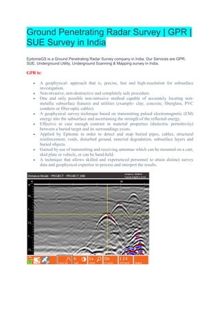
- 2. GPR METHOD Ground Penetrating Radar operates by transmitting high-frequency radio waves pulses down into the ground through an antenna. Ground Penetrating Radar is distinctly able at not only mapping buried structures but also relatively measuring their depth, and supplying an all-important thorough detail. The antenna is moved over the surface to be inspected. The transmitter redirects a diverging beam of energy which is reflected in various underground objects or different contacts between different earth materials. The radargram measured on the vertical scale is in units of the two-way travel time, that’s the time taken by the EM wave to travel down to a reflector and back to the surface. The travel time then is transformed into depth by relating it to on-site measurements or assumptions about the velocity of radar waves in the subsurface material under investigation. Radar wave speeds vary between 60–175 mm/ns for most geological materials. GPR waves can travel almost 30 meters deep in low conductivity material, as in case of dry sand or granite. Clays, shale, and other high conductivity materials may lessen or absorb GPR signals, leading to the reduction in depth of penetration to 1 meter or less. The GPR antenna can determine the depth of penetration as well. The selection of antennae is based according to the depth of interest and the size of the target. Penetration depth varies in contrast to the frequency. The higher the central frequency of antenna, the smaller will be the object size to be resolved. Higher antenna frequencies give higher resolution, but less penetration, and vice versa. The lateral and vertical resolution of the results varies from 0.01 to 1.0 meters, as per the choice of antenna frequency. Use of antennae having lower frequency in geological mapping is done to obtain the maximum penetration depth while higher frequencies are used in non-destructive testing for high- resolution imaging. Having a range of frequencies available (usually 50MHz–2.5GHz) makes GPR most suitable for identifying objects of different sizes at different depths and under different ground conditions. We are one of best Ground Penetrating Radar Survey Services, Best Underground Utilities Survey Services and GPR Survey Service in India. Phone: +91-96756 94400 Email: info@epitomegs.com Website: EpitomeGs.com