Clouds and precipitation 6.2
•Download as PPTX, PDF•
0 likes•160 views

Clouds and weather terms

Recommended
More Related Content
What's hot
What's hot (20)
Similar to Clouds and precipitation 6.2
Similar to Clouds and precipitation 6.2 (20)
More from Kella Randolph
More from Kella Randolph (20)
Recently uploaded
Recently uploaded (20)
Clouds and precipitation 6.2
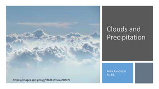
- 1. Clouds and Precipitation Kella Randolph M. Ed. https://images.app.goo.gl/zFbSFeThvau2DRLf9
- 2. Water vapor/humidity • Water vapor is the gaseous version of water. If we examine the amount of water vapor in the air, it is referred to as the HUMIDITY. If the air feels thick or moist, the humidity is high. Image: https://ak7.picdn.net/shutterstock/videos/14541817/thum b/1.jpg
- 3. Warm air rises. • Warm air RISES. The higher the air climbs the humidity also increases. Once the humidity reaches 100%, it develops into a CLOUD. https://c1.staticflickr.com/9/8485/8265072146_b216a812ae_b.jpghttp://alanbetts.com/image/1/1200/0/uploads/ocean-and-clouds-1276876479.jpg
- 4. Clouds and Precipitation • Clusters of water droplets (called cloud droplets) and crystallized frozen water (called ice crystals or snow crystals) form clouds. A cloud can contain both of these, depending on its temperature. For instance, a cloud's top may be cooler than the lower regions, creating a mix of liquid and frozen water. • Gravity causes all this water to fall as rain. The average size and volume of a cloud droplet is tiny, but, if a cloud droplet manages to attract enough water, the influence of gravity causes it to become a raindrop and fall. • Text: https://science.howstuffworks.com/nature/c limate-weather/atmospheric/cloud3.htm https://images.pexels.com/photos/1642660/pexels-photo- 1642660.jpeg?auto=compress&cs=tinysrgb&h=750&w=1260
- 5. Clouds • Clouds are essentially a collection of water vapor. Clouds can be made of ice crystals or tiny water droplets. If the water vapor becomes dense enough, PRECIPITATION happens. https://images.app.goo.gl/WrUu4vyeCKMFYT6x8 https://images.app.goo.gl/B8YuFmrc5yKyrJdv7
- 6. Our clouds fall into FOUR different types: cirrus, cumulus, stratus, and nimbus. CIRRUS clouds are composed of ICE crystals and appear very WISPY. They are found at higher ALTITUDES and can be seen ahead of a low-pressure system like a hurricane. CUMULOUS clouds look like FLUFFY cotton balls. They can be separate pieces and stretch vertical as much as they are horizontal. They are DENSE and have flat bottoms which designates the altitude where moisture begins to condense. STRATUS clouds are FLAT and broad clouds that form a layer, similar to a blanket. NIMBUS clouds are also known as rain clouds. These can be combined with the other three types such as CUMULONIMBUS.
- 7. CIRRUS clouds • CIRRUS clouds are composed of ICE crystals and appear very WISPY. They are found at higher ALTITUDES and can be seen ahead of a low-pressure system like a hurricane. https://upload.wikimedia.org/wikipedia/commons/3/36/Cirrus_sky_panorama.jpg
- 8. CUMULOUS clouds • CUMULOUS clouds look like FLUFFY cotton balls. They can be separate pieces and stretch vertical as much as they are horizontal. They are DENSE and have flat bottoms which designates the altitude where moisture begins to condense. Image: https://upload.wikimedia.org/wikipedia/commons/thumb/3/3c/GoldenMedows.jpg/1200px- GoldenMedows.jpg
- 9. STRATUS clouds • STRATUS clouds are FLAT and broad clouds that form a layer, similar to a blanket. • Image: https://scijinks.gov/clouds/
- 10. NIMBUS clouds • NIMBUS clouds are also known as rain clouds. They are usually large and have a dark grayish color. Nimbus cloud formations indicate that thunderstorms are building, and moving into an area. • These can be combined with the other three types such as CUMULONIMBUS. (Image of cumulonimbus cloud/lower right: https://images.app.goo.gl/FDQVnEXj6pb34oaG8) • Image of nimbus cloud: https://images.app.goo.gl/F8K3bqszbNXsZY2r8 Nimbus Cumulonimbus
- 13. Precipitation What happens when there is too much water vapor in the atmosphere? It begins to CONDENSE and fall back to the ground. That is the basis of all PRECIPITATION. Let’s look at it in a little more detail. https://images.app.goo.gl/DD2CFg3BNKsULKcL9
- 15. Rain • The air COOLS as it rises higher in the atmosphere. This cooling lowers the ENERGY in the water vapor and brings the particles closer together. The particles stick together when they collide and when they are big enough, form RAINDROPS. The raindrops fall to the ground when they are heavier than the updrafts can push back up. Image: https://images.app.goo.gl/e4ZAUPFpSKAchjo79
- 16. Snow • SNOW forms when the air is cold enough to freeze when the water vapor begins to condense high in the atmosphere. • Often it will melt as it falls through warmer air, but sometimes it is cold enough to stay a snowflake as it reaches the ground. https://images.app.goo.gl/GYQNtciryMutzHGN9 https://images.app.goo.gl/hHH3npAFmx7PkGm38 https://images.app.goo.gl/mmk 8EgrvPKnYF2hz6
- 17. Sleet • SLEET begins as snow - frozen water vapor. But as it falls, it melts back to a liquid. As it continues to fall, it FREEZES again into ice before it reaches the ground. https://images.app.goo.gl/1KyWhCdCoAxjmuwj6 https://images.app.goo.gl/dNHyoHams5xSMHki9
- 19. Freezing Rain • FREEZING RAIN forms similarly to sleet. The snow falls through warmer air and melts. This time it doesn’t melt until it reaches the ground. • Images: Left: https://images.app.goo.gl/2CRSGXLhv7sfyP9r8 • Center: https://images.app.goo.gl/LGVdsvQioixNwW9R8 • Right: https://blog.weatherops.com/how-does-freezing-rain-form
- 20. Hail • HAIL is often seen during THUNDERSTORMS or other severe weather events. It begins as FROZEN water and falls through the atmosphere. An UPDRAFT catches the ice and pushes it back up where it collects more water that freezes. The more times it goes up, the more layers are added and the larger the hail becomes. • Both Images: https://scijinks.gov/rain/